April 22 , 2025 .
Hawaii , Kilauea :
Monday, April 21, 2025, 8:49 AM HST (Monday, April 21, 2025, 18:49 UTC)
19°25’16 » N 155°17’13 » W,
Summit Elevation 4091 ft (1247 m)
Current Volcano Alert Level: WATCH
Current Aviation Color Code: ORANGE
Activity Summary:
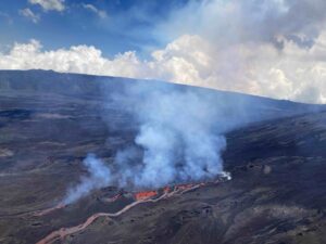
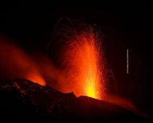
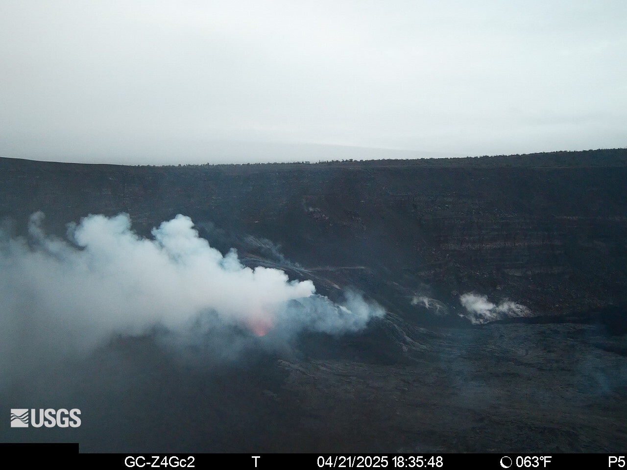
The ongoing Halemaʻumaʻu eruption is paused. On April 20, episode 18 resumed with lava flows erupting from the south vent starting at approximately 7:45 a.m. HST with 4 cycles of flows that ended around 12:44 p.m. HST. Glow continued to be observed from the vents overnight, but there was no noticeable spattering or vent overflows after the cycles ended. Tilt continues to show inflation, and a deflationary signal could accompany lava fountaining or more small lava flows could precede the fountaining phase.
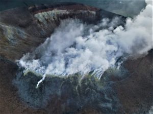
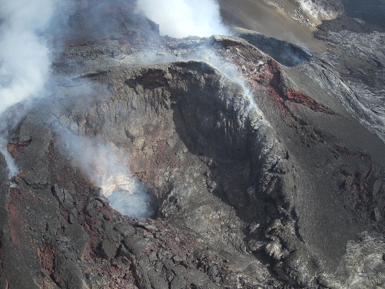
Kīlauea’s current eruption in Halemaʻumaʻu crater within Kaluapele (the summit caldera) began on December 23, 2024. There have now been 18 episodes separated by pauses in activity. All eruptive activity remains within Hawaiʻi Volcanoes National Park. No significant activity has been noted along Kīlauea’s East Rift Zone or Southwest Rift Zone. Current hazards include volcanic gas emissions and windblown volcanic glass (Pele’s hair) and tephra that have impacted Hawaiʻi Volcanoes National Park and nearby communities.
Summit Observations:
Episode 18 resumed at approximately 7:45 a.m. HST on April 20 with lava flows from the south vent being fed by a 6-10 foot (2-3 meter) high fountain. Eruptive activity paused from about 9:30 a.m. to 9:43 a.m. HST when flows resumed from the south vent. This was followed by another oscillation with the eruptive activity diminishing and stopping after 10:30 a.m. HST, which resumed at 10:50 a.m. HST with flows being fed by a 15 foot (5 meter) high dome fountain. Lava flows ceased just after 11:10 a.m. HST, ending the third cycle of activity. Lava flows resumed at 12:22 p.m. HST with low dome fountains and ended at 12:44 p.m. HST. Small gas pistoning events occurred every 3-5 minutes and are superimposed upon longer cycles of activity. Lava flows from the early cycles reached about a third of the way across the crater floor in a narrow band (about 1,500 feet or 500 meters in length). Tilt leveled and tremor increased slightly with the initial onset of eruptive activity. After eruptive activity paused tremor decreased and the summit began inflating again. Glow continued to be observed from the vents overnight, but there was no noticeable spattering or vent overflows after the cycles ended.
The UWD and SDH tiltmeters continue to show inflationary signals that have been persistent since the end of episode 17. As of this morning, UWD has measured approximately 17.5 microradians of inflationary tilt since 9:45 a.m. HST April 9; greater than the inflation at the start of episodes 16 and 17. High fountains as observed from previous episodes are expected when a strong deflationary signal is detected.
Volcanic gas emissions remain elevated and at heightened levels due to lava fountaining. The last sulfur dioxide (SO2) emission rate measured on April 10 was approximately 1,200 tonnes per day. Typical levels of Sulfur dioxide (SO2) emission have been about 1,000 tonnes per day during previous pauses. Sulfur dioxide (SO2) emission rates during earlier fountaining episodes have reached 50,000 tonnes per day. Plume remains a thick white color and continues to blow to the south and southwest. Strong degassing is currently occurring from both vents.
Source : HVO
Photos : USGS , USGS / M. Zoeller.
Costa Rica , Poas :
Latitude: 10.2
Longitude: -84.233
Altitude: 2,687 meters
Observed Activity:
Eruptive activity continues with ash emissions from Vent A and more intense eruptive pulses from Vent C. Weak eruptive activity was recorded this morning, but visibility of the crater was insufficient (due to cloud cover). Tremor intensity has decreased in recent days.
Observed Activity:
A strong explosive eruption was recorded at Poás Volcano, with no immediate precursor. The eruptive column reached a height of at least 2,000 meters above the crater.
Dense ash column. The plume is dispersing southwest.
Activity Level: Caution (3)
Volcán Poás erupted with significant force today, sending an ash and gas plume soaring over 2,000 meters above its crater, marking the most intense eruption of the year, according to the Observatorio Vulcanológico y Sismológico de Costa Rica (OVSICORI). The explosive event, described as a “fuerte erupción explosiva,” blanketed communities across Costa Rica’s Central Valley, prompting urgent health and safety measures.
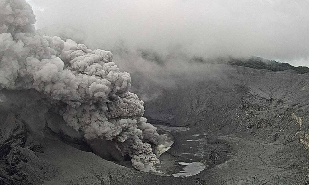
OVSICORI’s monitoring, detailed on ovsicori.una.ac.cr, recorded the plume reaching 4,708 meters above sea level. Ashfall affected Zarcero, Grecia, Alajuela, Heredia, and San José, with winds carrying particles southwest. The 10-minute eruption expelled ash, toxic gases, and incandescent materials, accompanied by heightened seismic activity and sulfur dioxide emissions exceeding 600 tons per day, signaling potential for further eruptions. OVSICORI volcanologist Geoffroy Avard warned of the volcano’s unpredictable behavior, driven by its acidic crater lake, Laguna Caliente.
Local reports and social media posts on X highlighted the eruption’s visibility, with residents sharing images of ash-covered homes, cars, and streets. OVSICORI urged the public to rely on official updates to counter misinformation spreading online, emphasizing the need for accurate information during such events.
The Comisión Nacional de Emergencias (CNE) maintained an orange alert for the national park, closed since March 28 due to prior volcanic activity, and issued a green alert for surrounding cantons. Authorities advised residents to wear N95 masks and limit outdoor exposure to protect against ash and toxic gas inhalation. The Ministerio de Ambiente y Energía (MINAE) reiterated warnings against illegal visits to restricted areas near the crater, citing dangers from unstable terrain and high gas concentrations.
Sources :Ovsicori , Tico times .
Photo : Ovsicori
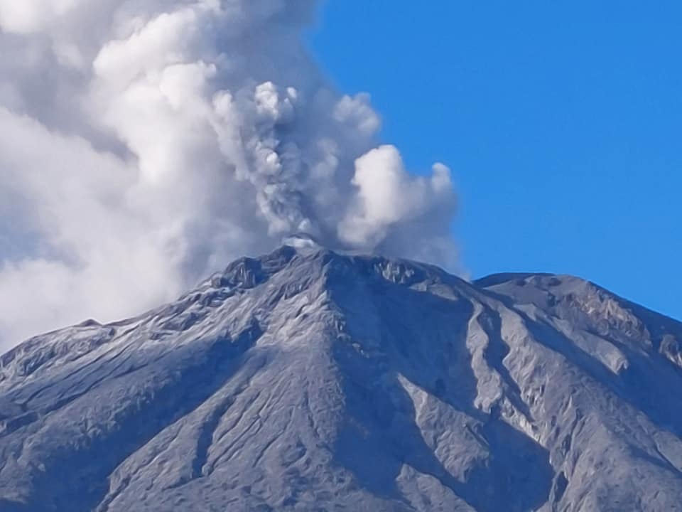
Philippines , Bulusan :
21 April 2025 , 10:00 PM
This is a notice of increased seismic activity at Bulusan Volcano.
A total of ninety-eight (98) volcanic earthquakes were recorded by Bulusan Volcano Network (BVN) since 3:00 AM of 12 April 2025. Of these, ninety-four (94) were weak and shallow volcano-tectonic (VT) earthquakes produced by rock fracturing and four (4) were low frequency volcanic earthquakes (LFVQ) produced by movement of fluids. The volcanic earthquakes were generated within 20 kilometers depth beneath the Bulusan edifice with nearly half being shallow events. In contrast, degassing activity at the summit crater and active vents has been very weak to moderate for the same period. The slight increase in volcanic earthquake activity could be caused by hydrothermal activity, which could lead to short-term pressurization of the edifice.
Alert Level 0 (Normal) is maintained over Bulusan Volcano but there are chances of steam-driven or phreatic eruptions from the crater and/or its active vents on the summit that could occur suddenly and without warning. Local government units and the public are thus advised to refrain from venturing into the 4-kilometer radius Permanent Danger Zone (PDZ), particularly near the vents on the south-southeastern slopes, due to the possible threat of sudden volcanic hazards such as rockfall, landslide, ballistic projectiles, small pyroclastic density currents or “uson” and others. Civil aviation authorities must also advise pilots to avoid flying close to the volcano’s summit as ash from any sudden phreatic eruption can be hazardous to aircraft.
DOST-PHIVOLCS is closely monitoring Bulusan Volcano’s condition and any new development will be relayed to all concerned.
Source : Phivolcs
Photo : Sorsogon news. ( 2022 )
Indonesia , Lewotobi Laki-laki :
Increased eruptive activity at Mount Lewotobi Laki-laki, April 21, 2025.
Visual and seismic observations of Mount Lewotobi Laki-laki, taken from April 14 to 21, 2025, are as follows:
The volcano is clearly visible, even though it is covered in fog. White smoke of thin, medium, to thick intensity was observed in the main crater, at an altitude of approximately 100 to 800 meters.
Types of earthquakes recorded between April 14 and 21, 2025:
87 eruption earthquakes,
206 emission earthquakes,
68 harmonic tremors,
11 low-frequency earthquakes,
29 deep volcanic earthquakes,
8 local tectonic earthquakes,
34 distant tectonic earthquakes,
3 flood tremors,
1 continuous tremor with a dominant amplitude of 7.4 mm.
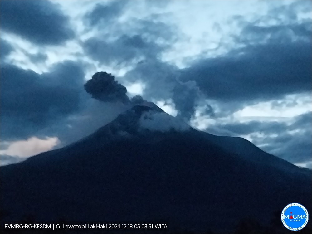
Visual observations between April 14 and 21, 2025, showed a significant increase in volcanic activity at Mount Lewotobi Laki-laki, with the average height of the eruptive column reaching 2,500 to 3,000 meters. The glow of the glow was still faintly visible around the summit, indicating the possible presence of incandescent material at shallow depths. Deposits of lava and lahar-forming material are found in the west-northwest and north-northeast areas of the crater of Mount Lewotobi Laki-laki.
During this period, the number of eruption earthquakes decreased. This indicates that the previously low internal pressure has transformed into a fairly strong surge. Consequently, while previously only ash eruptions occurred, eruptions are now more frequent.
Exhaled smoke is visible around the crater, with moderate to high pressure. Smoke is also visible from the northwest side of the summit, which resembles a fissure and tends to be thin, while in the solfatara fracture on the northeast side, the smoke appears thin to moderate. The appearance of crater smoke (solfatara) is due to the presence of an alteration zone (weak zone), so smoke escapes from this area. This area is susceptible to a directed explosion (direct eruption in a single direction) that may be directed towards the northwest, northeast, and southwest of Mount Lewotobi Laki-laki.
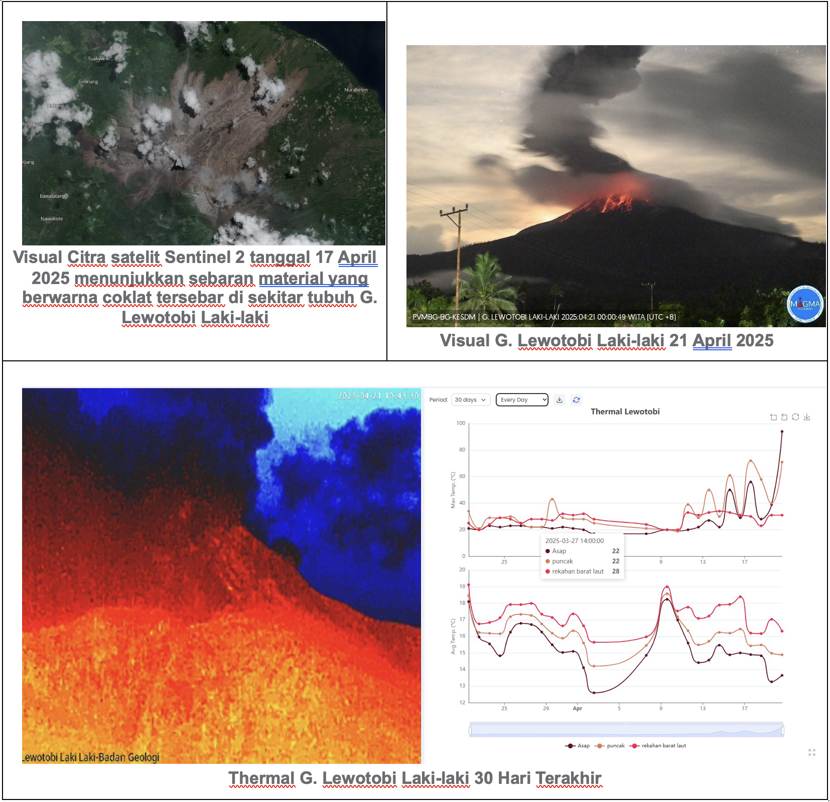
The length of the lava deposit to the northwest is still considered stable, approximately 3.8 km from the summit of Mount Lewotobi Laki-laki. Meanwhile, the lava flow to the northeast reaches a length of approximately 4.2 km. The influence of the slope in both directions allows the lava to continue moving.
The number of eruption earthquakes increased significantly during this period. This increase is due to the increased activity of deep volcanic earthquakes and low-frequency earthquakes, indicating an influx of magma from the previous period. The buildup of pressure then pushes the material out of the crater, triggering an eruption.
The number of harmonic tremors has decreased compared to the previous period. This indicates that vibrations due to the movement of fluids (magma, gas, or water vapor) beneath Mount Lewotobi Laki-laki are beginning to diminish. Fluid movement and gas release from magma filling the fissures continue to occur, but tend to weaken and are still occurring at shallow depths, moving toward the surface.
Low-frequency earthquakes have increased slightly, indicating an increased flow of magmatic fluid from the conduit to the surface, which is located at medium to shallow depths.
The number of deep volcanic earthquakes has increased, indicating increased intensity of magmatic activity in the magma chamber of Lewotobi Laki-laki volcano, at medium to deep depths.
The results of a comprehensive analysis and assessment of visual and instrumental monitoring show that visual and seismic activity on Mount Lewotobi Laki-laki remains relatively high, so the activity level of Mount Lewotobi Laki-laki remains at Level III (SIAGA).
Source et photos : PVMBG.
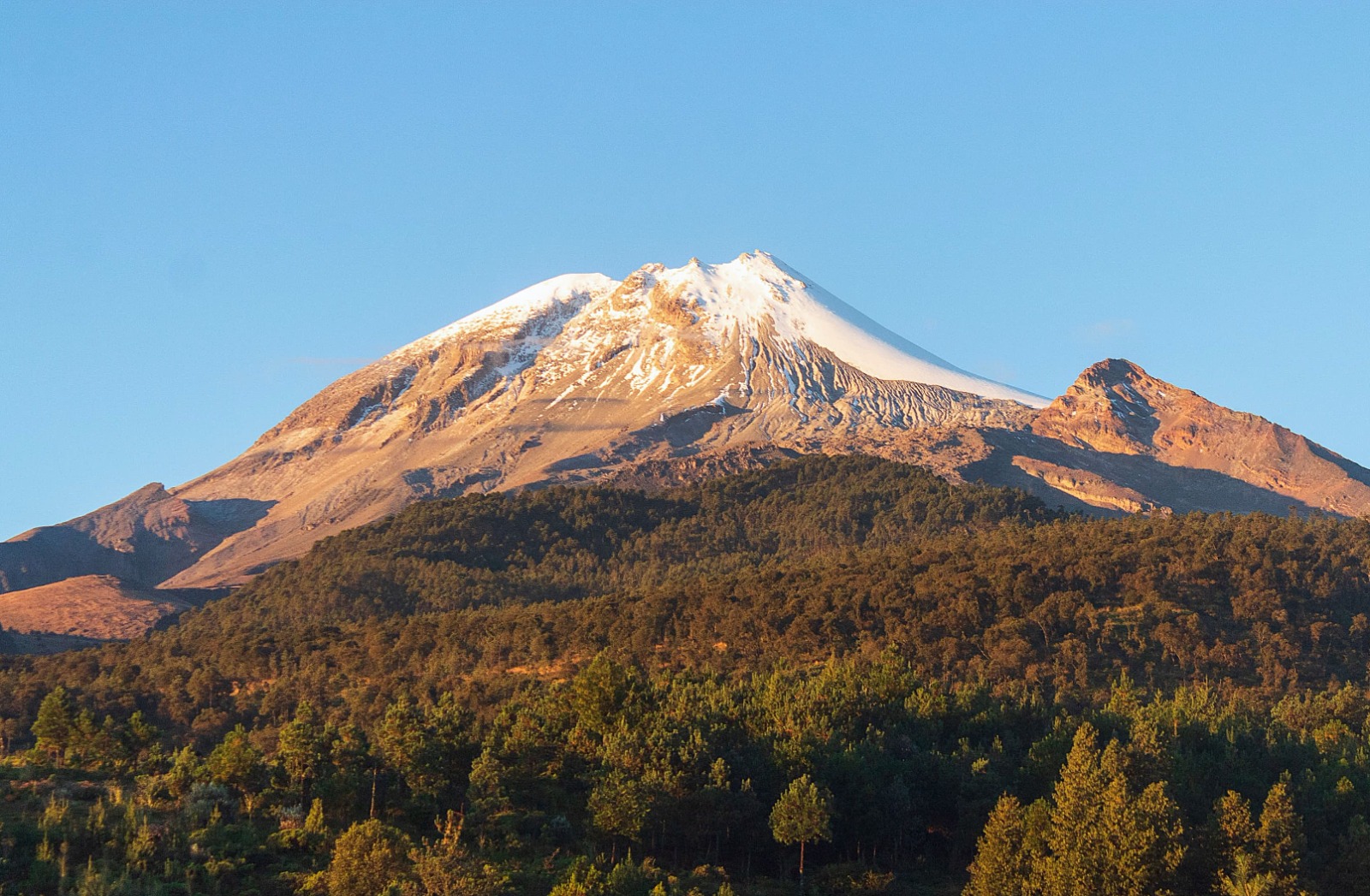
Mexico , Pico de Orizaba :
What’s happening with the Pico de Orizaba volcano?
In recent days, information has circulated regarding the activity of the Pico de Orizaba volcano, also known as Citlaltépetl. In response, the National Center for Disaster Prevention (Cenapred) informs you of the following:
Is Pico de Orizaba active?
Yes, Citlaltépetl is an active volcano; it is considered so because it has exhibited eruptive activity over the past 10,000 years. Its last major eruption occurred between 1864 and 1867, when fumaroles and ash emissions were observed.
Is it currently erupting?
No, the volcano is not currently erupting. The current activity is part of its baseline behavior, which has been constant and without significant change since 1998, the year Cenapred set up a monitoring system that it maintains to this day.
What type of activity is it currently experiencing?
Pico de Orizaba’s activity consists mainly of:
Volcano-tectonic earthquakes: These occur on average 10 times per month, but are not noticed by the population.
Hydrogeochemical variations in nearby springs: These have not shown significant changes over the past 25 years.
Flank or slope deformations: These have not shown substantial changes.
Fumarole emissions: This is normal for active volcanoes.
This type of activity is common on dormant active volcanoes and does not pose an immediate risk.
Who monitors the volcano?
Since 1998, Cenapred has maintained a permanent monitoring system in collaboration with the National Autonomous University of Mexico (UNAM) and the University of Veracruz (UV). This system includes:
Three seismic stations located on the volcano’s slopes
Continuous deformation measurement equipment using the Global Navigation Satellite System (GNSS)
Periodic hydrogeochemical and geodetic sampling campaigns
The data obtained are analyzed by specialists from the three institutions, allowing for the rapid identification of any changes in the volcano’s activity and notification to the relevant authorities for civil protection purposes.
What to do?
There is currently no cause for alarm. A volcano with these characteristics can remain in this state for a long time, even hundreds or thousands of years, decreasing or increasing its activity and exhibiting eruptive processes of varying magnitude.
It is important to stay informed through official sources such as Cenapred or the National Coordination of Civil Protection. The volcano is monitored 365 days a year, and any significant changes will be reported promptly.
Source et photo : Cenapred