March 15 , 2025 .
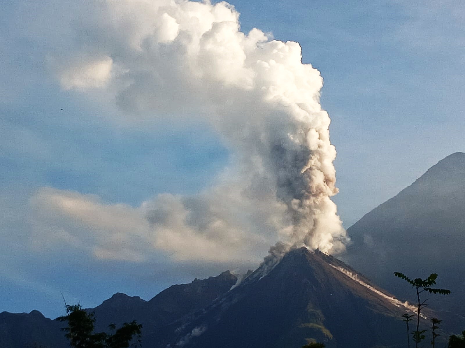
Alaska , Spurr :
Volcanic unrest continues at Mount Spurr volcano and is characterized by ongoing earthquake activity, surface deformation, and volcanic gas emissions. Seismicity remains elevated and increased slightly compared to last week. Over the past week, 145 earthquakes were located, most in the summit region and fewer near Crater Peak. No unusual activity was observed in satellite or webcam data, although minor steam emissions from the summit of the volcano were sometimes seen from nearby communities during periods of clear weather. Overflights on March 7 and 11 to measure volcanic gases found elevated levels of SO2 and CO2 being emitted from the summit of Mount Spurr and CO2 being emitted from Crater Peak. Reactivated gas vents were also observed within the crater at Crater Peak. AVO released an Information Statement earlier this week that discusses these observations and more. The Mount Spurr monitoring network is functioning well, although the web camera at station CKT remains obscured by snow and ice. .
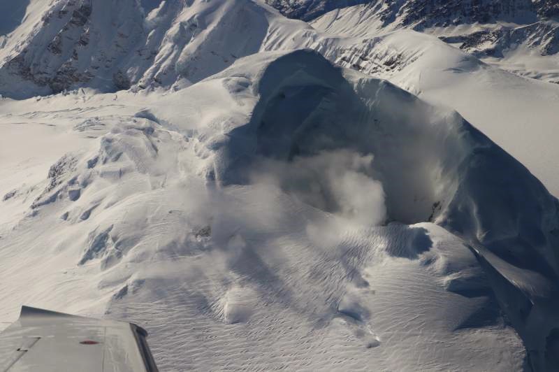
The south side of the summit crater at Mount Spurr during the 03/11/2025 overflight. Fumarole fields and steaming cracks around the flanks of the summit are visible to the lower left of the summit crater.
AVO continues monitoring activity at Mount Spurr for signals indicating that the volcano is moving closer to an eruption. Based on previous eruptions, changes from current activity in the earthquakes, ground deformation, summit lake conditions, and fumarolic activity would be expected if magma began to move closer to the surface. Therefore, if an eruption occurred, it would be preceded by additional signals allowing warning.
The volcano is monitored using local seismic, infrasound, web camera, and GNSS stations along with regional infrasound, lightning networks and satellite data.
Source : AVO
Photo : Kushner, Skye.
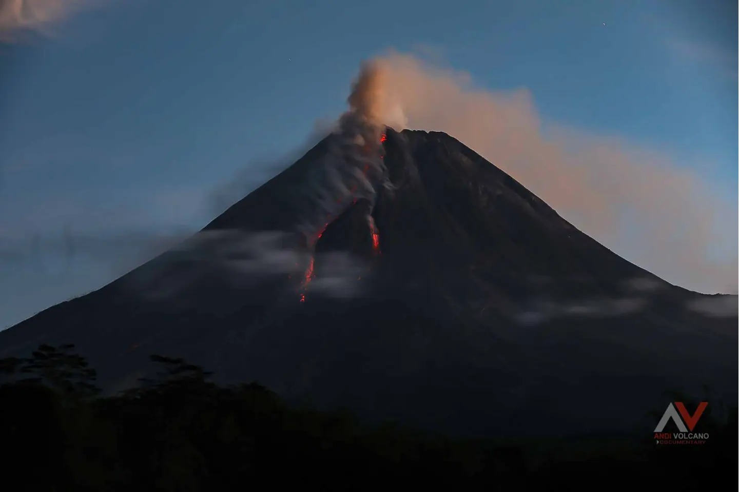
Indonesia , Merapi :
MOUNT MERAPI ACTIVITY REPORT, March 7-13, 2025
OBSERVATION RESULTS
Visual
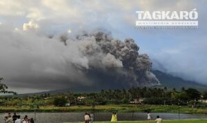
The weather around Mount Merapi is generally sunny in the morning and evening, while it is hazy during the day. White smoke, thin to thick, with low to moderate pressure, and a smoke height of 475 m was observed from the Mount Merapi observation post in Babadan on March 8, 2025, at 07:00 WIB. This week, lava avalanches were observed 54 times in the southwest (above Kali Bebeng) up to a maximum of 2000 m, 33 times up to Kali Krasak up to a maximum of 2000 m, and 31 times in the west (above Kali Sat/Putih) up to a maximum of 2000 m. The highest hot spot in the southwest dome was measured at 284.5 oC, higher than the previous measurement. The morphology of the southwest dome was observed to have changed due to lava flow activity. For the central dome, no significant morphological changes were observed. In the central dome, the measured hot spot was 228.5 oC, relatively identical to the previous measurement. According to aerial photo analysis, the southwest dome has experienced a volume increase to 3,626,200 m3. Meanwhile, the measured volume of the central dome remains at 2,368,800 m3.
Seismicity
This week, the seismicity of Mount Merapi recorded:
1 shallow volcanic earthquake (SV),
787 multi-phase earthquakes (MP),
1001 avalanche earthquakes (RF),
6 tectonic earthquakes (TT).
The intensity of the earthquakes this week remains quite high.
Deformation
The deformation of Mount Merapi monitored using EDM and GPS this week showed no significant changes.
Rainfall and Lahars
This week, it rained at the Mount Merapi observation post, with the highest rainfall intensity of 43 mm/hour for 32 minutes at the Kaliurang observation post on March 9, 2025, and there were no reports of increased discharge in the rivers flowing down from Mount Merapi.
Conclusion
Based on the results of visual and instrumental observations, it is concluded that:
Volcanic activity at Mount Merapi is still quite high in the form of effusive eruptions. The activity status is defined as « SIAGA » level.
Source: BPPTKG
Photo : Andi Volcanist .
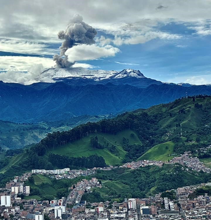
Colombia , Nevado del Ruiz :
Manizales, March 11, 2025, 5:30 p.m.
Monitoring the activity of the Nevado del Ruiz volcano, the Colombian Geological Survey (SGC), an entity affiliated with the Ministry of Mines and Energy, reports that:
During the week of March 4 to 11, 2025, the volcano continued to exhibit unstable behavior. Compared to the previous week, the main variations in the monitored parameters were:
– Seismic signals related to fluid dynamics in volcanic conduits increased in the number of recorded earthquakes and in the seismic energy released.
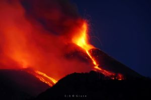
These signals exhibited low to moderate energy levels, and some of them were associated with continuous and pulsed ash emissions, which were confirmed by the cameras (conventional or thermographic) used to monitor the volcano. Changes in the apparent temperature of the emitted material were also observed in connection with these ash emissions. In this regard, it is worth noting the pulsatile emission of gas and ash recorded on March 11 at 1:00 a.m., which was associated with the largest temperature change of the week and one of the three highest estimated so far this year.
Similarly, surveillance cameras were able to observe an incandescence associated with this event.
– Seismic activity associated with rock fracturing processes within the volcanic edifice increased the number of recorded earthquakes and decreased the released seismic energy. Seismic activity was mainly located in the Arenas crater, at depths less than 2 km from the volcano’s summit, and on the northeast flank, at a distance of less than 5 km from the crater and at depths between 2 and 6 km. Less frequently, earthquakes were recorded on the volcano’s east, southeast, and southwest flanks.
In addition, low-energy seismic activity was recorded, linked to the activity of the lava dome (protuberance or mound) located at the crater floor.
– The emission of water vapor and gases, mainly sulfur dioxide (SO₂), into the atmosphere through the Arenas crater was variable. Estimated daily SO₂ outgassing values decreased compared to previous weeks, largely due to atmospheric conditions such as high cloud cover and wind direction, which were unfavorable for data collection. Satellite monitoring, which is being conducted to complement the assessment of this parameter, continues to show significant SO₂ releases.
– The vertical height of the gas column remained mainly below 900 m measured above the volcanic summit, with a maximum of 1100 m. In dispersion, the column reached a maximum value of 2200 m during the emission of gas and ash on March 5 at 8:50 a.m. The dispersion direction showed a predominant trend toward the west-southwest and southwest of the volcano throughout the week, with occasional variations toward the south-southwest.
– By monitoring thermal anomalies at the floor of Arenas Crater using satellite monitoring platforms, some anomaly reports with low to moderate energy levels have been obtained. The moderate anomaly report for today, March 11, stands out, with a value not seen since January 23 of this year.
Source : SGC
Photo : Alex Jimenez Matiz
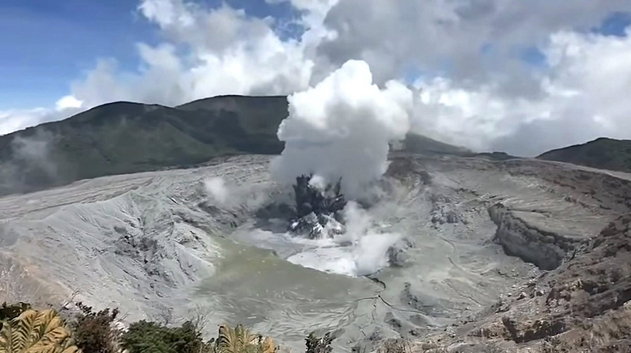
Costa Rica , Poas :
Latitude: 10.20°N;
Longitude: 84.23°W;
Altitude: 2687 m
Current activity level: Caution
On Sunday, March 9, the magnitude of the eruptions increased. Four major eruptions were observed, with eruptive columns (with solid material) up to 300 m and steam plumes up to 1 km above the eruptive focus, emitting ash that settled northeast of the crater. These were the largest eruptions of this eruptive period (January 5, 2025 to present). Eruptive activity ceased overnight.
On Thursday, March 13, another smaller eruption was observed, the height of which could not be determined due to the abundant and continuous plume of steam and gas. The eruptions on the 9th were the largest of this eruptive period, with infrasound magnitudes greater than 3.5. Before this sequence, a sustained increase in tremor amplitude was observed. On the 11th, in the early hours of the morning, two episodes of intense tremor were observed. On the 13th, an increase in tremor amplitude was observed again preceding the eruption of that day, which had an infrasound magnitude of 2.3. Following the eruptions on the 9th, an increase in volcano-tectonic seismicity was observed, particularly distally. The number of high-frequency events remains stable, while sporadic long-duration events are detected.
Geodetic monitoring continues to detect vertical uplift affecting the immediate crater area as well as the remaining GNSS stations located at the summit. This uplift is associated with volcanic extension.
The MultiGAS station recorded relatively stable gas ratios this week, with average SO2/CO2 values of 1.3 ± 0.4 and H2S/SO2 of 0.09 ± 0.04. SO2 concentrations of up to 18 ppm were recorded at the lookout this week. The SO2 flux did not change significantly this week compared to the previous week (368 ± 177 t/d). The OMI instruments on the SENTINEL satellite continue to detect atmospheric SO2 daily, with high values exceeding those of 2024, reaching 840 tons on March 13.
An increase in the lake level was observed due to the eruptions of March 9, which allowed the lakes to be connected, and a decrease after this eruptive activity, generating two distinct lagoons again centered on each of the mouths A and C.
Source : Ovsicori
Photo : Rod Cortes / FB
Guatemala , Santiaguito :
Weather Conditions: Clear.
Wind: Northeast.
Precipitation: 0.0 mm.
Activity:
The observatory reports activity in the Caliente Dome, with moderate to abundant degassing columns continuously dispersing in south, west, and southwest directions due to wind variability. Between 2 and 7 weak to moderate explosions per hour are recorded, accompanied by moderate block avalanches in south and southwest directions, as well as accumulation of hot material mainly toward the southwest flank in the upper part of the lava flow. At night, intermittent incandescence can be observed during moderate avalanches and sustained incandescence at the beginning of the lava flow.
Moderate to strong explosions lift columns of gas and ash to heights of up to 3,700 meters (12,140 feet) and trigger short-distance pyroclastic flows that propagate on all flanks and weak and/or strong avalanches that can be heard several kilometers from the volcano. Given the wind direction, ashfall is possible at Finca Santo Domingo, Montebello, La Tranquilidad, Rosario, and San Marcos Palajunoj, among other locations. The occurrence of moderate to strong block and ash flows, as well as possible long-distance pyroclastic flows in different directions, cannot be ruled out. Therefore, the recommendations of special bulletin BESAN-002-2025 should be followed.
Source : Insivumeh
Photo : Conred ( 10/2024).