June 10 , 2022.
Philippines , Bulusan :
This is a notice of an increase in seismic activity at Bulusan Volcano. Since 5:00 AM today until as of this release, a total of 45 volcanic earthquakes including two (2) low-frequency volcanic earthquakes have been recorded by the Bulusan Volcano Network. Most of these were weak and shallow events, but may indicate that a phreatic eruption could possibly occur within the next few hours.
The public is reminded that Alert Level 1 status prevails over Bulusan Volcano, which means that it is currently in an abnormal condition. Local government units and the public are reminded that entry into the 4-kilometer radius Permanent Danger Zone (PDZ) must be strictly prohibited and that vigilance in the 2-kilometer Extended Danger Zone (EDZ) on the southeast sector must be exercised due to the increased possibilities of sudden and hazardous phreatic eruptions. Civil aviation authorities must also advise pilots to avoid flying close to the volcano’s summit as ash from any sudden phreatic eruption can be hazardous to aircraft. Furthermore, people living within valleys and along river/stream channels especially on the southeast, southwest and northwest sector of the edifice should be vigilant against sediment-laden stream flows and lahars in the event of heavy and prolonged rainfall should phreatic eruption occur.
DOST-PHIVOLCS is closely monitoring Bulusan Volcano’s condition and any new development will be communicated to all concerned stakeholders.
Source et photo: Phivolcs.
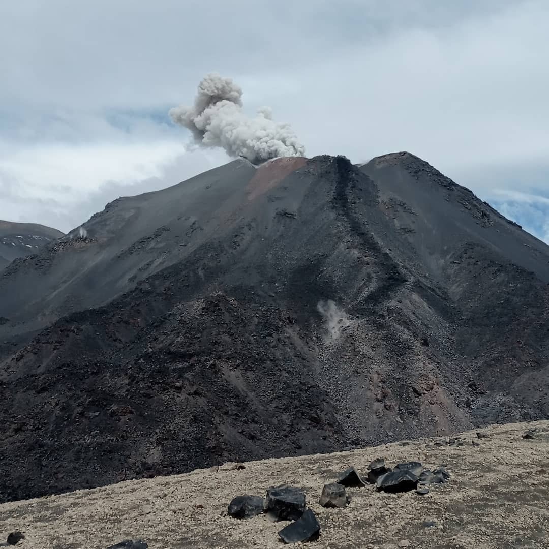
Chile , Nevados de Chillan :
Seismology
The volcano-tectonic (VT) type seismicity recorded a total of 42 events caused by brittle rupture processes; the most energetic event had a local magnitude (ML) equal to 4.5, whose source is located near the volcanic edifice, but due to technical problems obtained a location that made interpretation difficult of the current state of the volcanic system. This earthquake was considered the highest energy fracture event recorded in this eruptive process.
Long period (LP), explosion (EX) and tremor (TR) seismicity continued to be recorded, associated with fluid dynamics within the volcanic system. 758 LP-type earthquakes were classified, including 234 linked to surface explosions, confirmed by the presence of acoustic waves and/or gaseous emissions, often with particle input. The size of the largest LP earthquake estimated from the reduced displacement parameter (DR) reached a value equal to 362 cm2, causing an incandescent surface emission with crack deployment. Regarding TR type seismicity, 330 episodes were identified, the most important of which reached a DR of 111 cm2. Daily energy levels calculated for earthquakes associated with fluid movement remained within a range considered low compared to periods of greatest volcanic activity, with a significant presence of tremor-type seismicity.
Fluid Geochemistry
Data on sulfur dioxide (SO2) emissions obtained by optical differential absorption spectroscopy (DOAS) equipment, corresponding to the Philippi and Chillán stations, installed 1.5 km to the South-South-East (SSE) and 2.7 km east-southeast (ESE) of the active crater, respectively, showed an average value of 363 ± 58 t/d, with a maximum daily value of 569 t/d, recorded on 18 may. A decrease in SO2 emission rates has been observed, however, these still remain above baseline, which is consistent with the presence of Dome 4, located inside the active Nicanor crater.
No anomalies were reported in the emissions of sulfur dioxide (SO2) into the atmosphere in the area near the volcanic complex.
Satellite thermal anomalies
Four thermal alerts were recorded in the area associated with the volcanic complex during the period, with a maximum Volcanic Radiative Power (VRP) of 3 MW on May 21 and 27, a value considered moderate according to the data processed by the Observation Middle Infrared of Volcanic Activity (MIROVA, http://www.mirovaweb.it/).
At the same time, according to the analytical processing of satellite images (Sentinel 2-L2A in combination of false color bands), luminance anomalies were observed on May 18, 20, 25 and 28.
Satellite geomorphological analysis
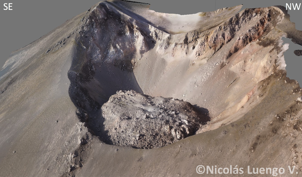
From analysis with Planet Scope OrthoTile, Sentinel 2 L2A and SkySat Collect satellite images, the permanence of a dome-like effusive body nestled in the Nicanor crater (Dome 4), with an area of 1687 m2, has observed, without significant variations compared to the area estimated in the previous Skysat image of May 9, 2022 (1626 m2), which shows its low growth rate.
On the other hand, the detailed analysis of the SkySat Collect high-resolution satellite image shows the permanence of the main cracks and emission centers located in an East-West line on Dome 4 and on its limits, from which came explosive activity. with low pyroclast content and mainly passive degassing. In addition, the development of an incipient morphology of 552 m2 associated with the accumulation of pyroclasts was identified immediately west of Dome 4 with a distinct emission center, from which it is inferred that the explosions with the highest pyroclast content of the evaluated period were generated.
On the other hand, Sentinel 2 L2A images in false colors indicate an area of anomalous thermal radiation, coinciding with Dome 4 without major variations in its spatial distribution.
Source : Sernageomin.
Photos : Sernageomin (archive), Nicolas Luengo ( Archive 2018).
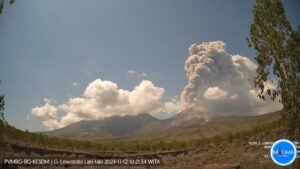
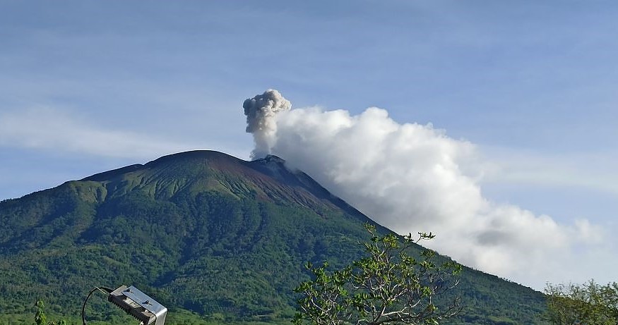
Indonesia , Ili Lewotolok :
VISUAL OBSERVATIONS
The volcano was clearly visible until it was covered in fog. White / gray colored smoke is observed from the main crater, with high intensity about 250-400 meters above the summit. The weather was clear to cloudy, the wind weak towards the West and the North-West.
SEISMICITY OBSERVATIONS
It was recorded:
1 eruption earthquake with an amplitude of 15 mm and an earthquake duration of 93 seconds.
39 emission earthquakes with an amplitude of 2.4 to 12.3 mm, and an earthquake duration of 12 to 170 seconds.
33 non-harmonic tremors with an amplitude of 2.1 to 8.9 mm and an earthquake duration of 24 to 397 seconds.
1 deep volcanic earthquake with an amplitude of 27.4 mm, an S-P of 0.45 seconds and an earthquake duration of 10.3 seconds.
1 continuous tremor with an amplitude of 0.5 mm, dominant by 0.5 mm.
RECOMMENDATIONS
[1] Based on the results of a thorough analysis and assessment, on June 8, 2022, the activity level of the Ili Lewotolok volcano is still at level III (SIAGA) with new recommendations adjusted to the latest potential threats .

[2] In Level III (SIAGA) activity, people around G. Ili Lewotolok as well as visitors/mountaineers/tourists are recommended not to engage within 3 km of the summit/ G. Ili Lewotolok crater, a radius of 3.5 km for the South-East sector, a radius of 4 km for the East and North-East sectors. Residents of Lamawolo Village, Lamatokan Village and Jontona Village should always be aware of the potential threat of incandescent lava avalanches and hot clouds from the eastern part of G. Ili Lewotolok summit/crater
[3] Since volcanic ash has so far fallen in several areas around G. Ili Lewotolok, people living around the rivers flowing from the summit of G. Ili Lewotolok should be aware of the potential threat dangers of lahars, especially during the rainy season.
Source et photos : Magma Indonésie.
Hawaii , Kilauea :
19°25’16 » N 155°17’13 » W,
Summit Elevation 4091 ft (1247 m)
Current Volcano Alert Level: WATCH
Current Aviation Color Code: ORANGE
Activity Summary:
The summit eruption of Kīlauea Volcano, within Halemaʻumaʻu crater, continued over the past 24 hours. All recent lava activity has been confined to the crater, and current data indicate that this scenario is likely to continue. No significant changes have been noted at summit or in the East Rift Zone.
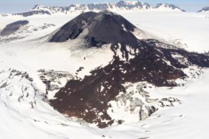
Halemaʻumaʻu crater Lava Lake Observations:
Eruption of lava from the Halemaʻumaʻu crater western vent into the active lava lake and ooze-outs onto the crater floor have continued over the past 24 hours. The active lava lake has shown continuous surface activity with lava lake levels stable over the last 24 hours, remaining below overflow. Minor lava ooze-out activity occurred along the edges of the crater floor. Overflight measurements on May 10, 2022 indicated that the crater floor had seen a total rise of about 106 meters (348 feet) .
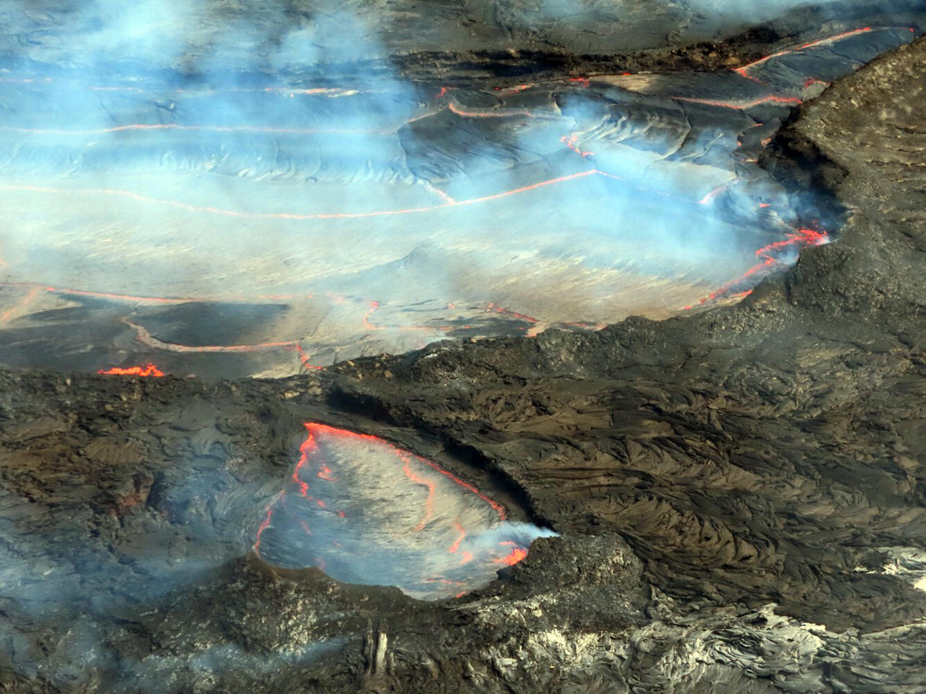
In this telephoto image taken from the south rim of Halema‘uma‘u, spattering and crustal foundering is visible in the east end of the active lava lake within the crater at Kīlauea’s summit. Slabs of thin silvery crust are visible covering most of the lava lake surface; this crust was moving in a west-to-east motion the morning of June 8.
Summit Observations:
Summit tiltmeters recorded deflation over the past 24 hours. A sulfur dioxide (SO2) emission rate of approximately 1,900 tonnes per day (t/d) was measured on June 8, 2022.
Source : HVO.
Photo : USGS/ J. Schmith.
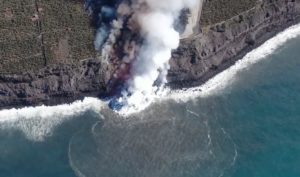
Guatemala , Fuego :
Type of activity: Vulcanian
Morphology: Stratovolcano composite
Geographical location: 14°28’54˝ Latitude N. 90°52’54˝ Longitude W.
Altitude: 3,763 meters.
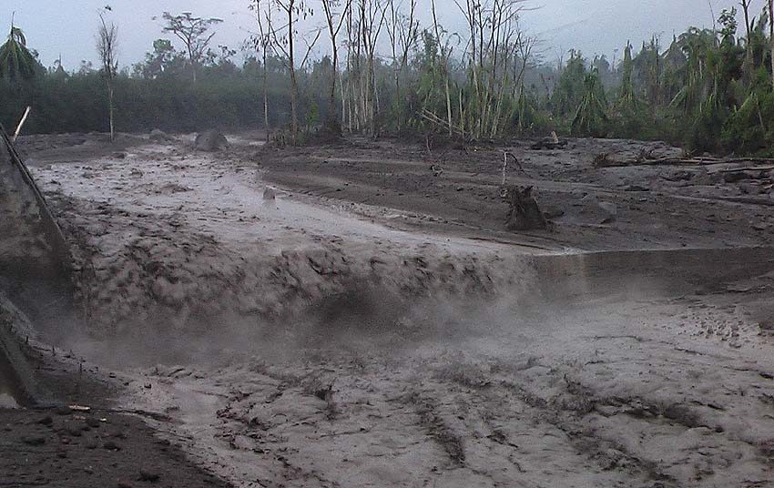
LAHARES IN THE BARRANCAS SECA, MINERAL AND TANILUYÁ, TRIBUTARIES OF THE PANTALEON RIVER.
The persistent rain on the Fuego volcano currently produces the descent of lahars with weak characteristics in the Barrancas Seca, Mineral and Taniluyá, tributaries of the Pantaleón River, on the southwestern flank of the volcano. Given the heavy rains in the area, it is possible that these lahars will intensify to moderate or strong levels, dragging branches and trunks of trees, fine sediments and boulders of sizes between a few tens of centimeters up to 1 or 2 meters. If these rains continue, it is expected that more lahars will continue to be generated overnight and early in the morning.
Source : Insivumeh
Photo : Caroline Sarrazin .