June 06 , 2022.
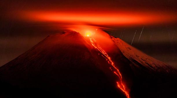
Philippines , Bulusan :
BULUSAN VOLCANO UPDATE , 05 June 2022 , 08:00 P.M. .
The 10:37 AM eruption from Bulusan Volcano’s summit crater produced a sluggish gray ash plume that rose more than a kilometer and dispersed wet ash to the west coincident with rainfall over the edifice. Thin fine ashfall fell on the general northwestern sector of the edifice and affected the barangays of Puting Sapa, Añog, Guruyan, Catanusan, Buraburan, Bacolod, and Sangkayon in Juban and Bolos in Irosin, Sorsogon Province. Rumbling sound and sulfurous odor were also observed by residents of Brgys. Añog, Guruyan, and Catanusan. After the eruption, degassing was observed from the crater and, for the first time this year, from the northwest summit vent. A total of 27 weak volcanic earthquakes were recorded until 4:00 PM today by the Bulusan Volcano Network.
Fine ashfall can cause irritation and breathing problems especially among the vulnerable population – the elderly, children, expecting mothers and those with respiratory disorders – and can be particularly dangerous when inhaled in copious amounts. In addition, ashfall even when thin but having high amounts of sulfur can also cause irritation. Affected populations are advised to protect their mouths and noses using N95 grade facemasks or wet cloth or towel. Motorists are advised to drive with extreme caution as ash can cause poor visibility and, when wet, can make roads slippery.
Alert Level 1 status remains in effect over Bulusan Volcano, which means that it is currently in an abnormal condition. Local government units and the public are reminded that entry into the 4-kilometer radius Permanent Danger Zone (PDZ) must be strictly prohibited and that vigilance in the 2-kilometer Extended Danger Zone (EDZ) on the southeast sector must be exercised due to the increased possibilities of sudden and hazardous phreatic eruptions that can occur without warning. Civil aviation authorities must also advise pilots to avoid flying close to the volcano’s summit as ash from any sudden phreatic eruption can be hazardous to aircraft. Furthermore, people living within valleys and along river/stream channels especially on the southeast, southwest and northwest sector of the edifice should be vigilant against sediment-laden stream flows and lahars in the event of heavy and prolonged rainfall should phreatic eruption occur. DOST-PHIVOLCS is closely monitoring Bulusan Volcano’s condition and any new development will be communicated to all concerned stakeholders.
Source : Phivolcs.
Photo : Phivolcs via vulkane.net
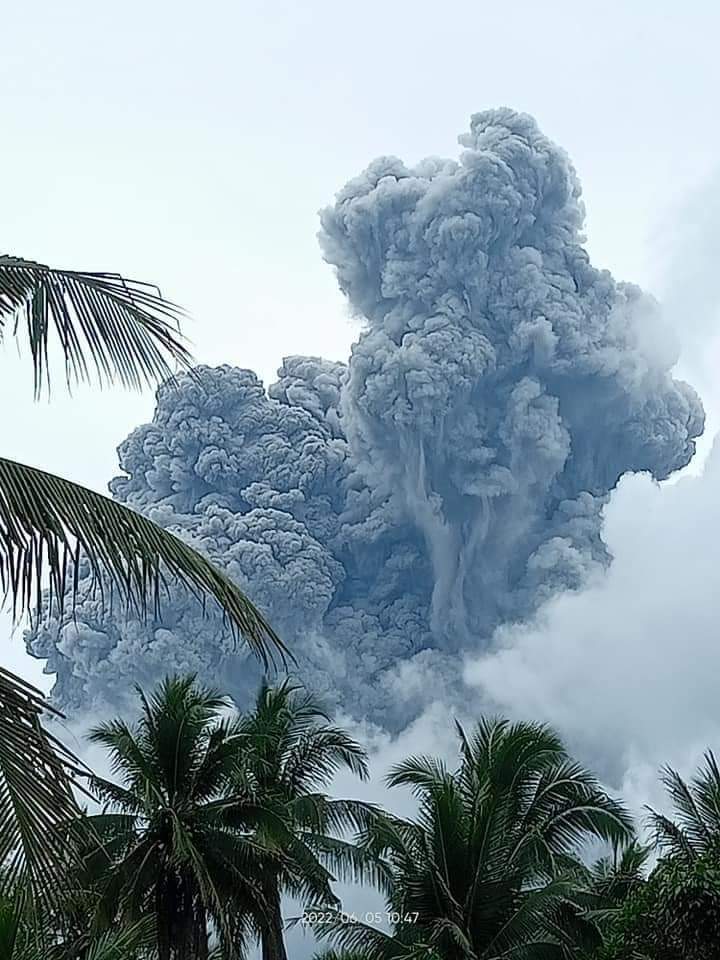
Indonesia , Semeru :
VOLCANO OBSERVATORY NOTICE FOR AVIATION – VONA
Issued : June 06 , 2022
Volcano : Semeru (263300)
Current Aviation Colour Code : ORANGE
Previous Aviation Colour Code : orange
Source : Semeru Volcano Observatory
Notice Number : 2022SMR150
Volcano Location : S 08 deg 06 min 29 sec E 112 deg 55 min 12 sec
Area : East java, Indonesia
Summit Elevation : 11763 FT (3676 M)
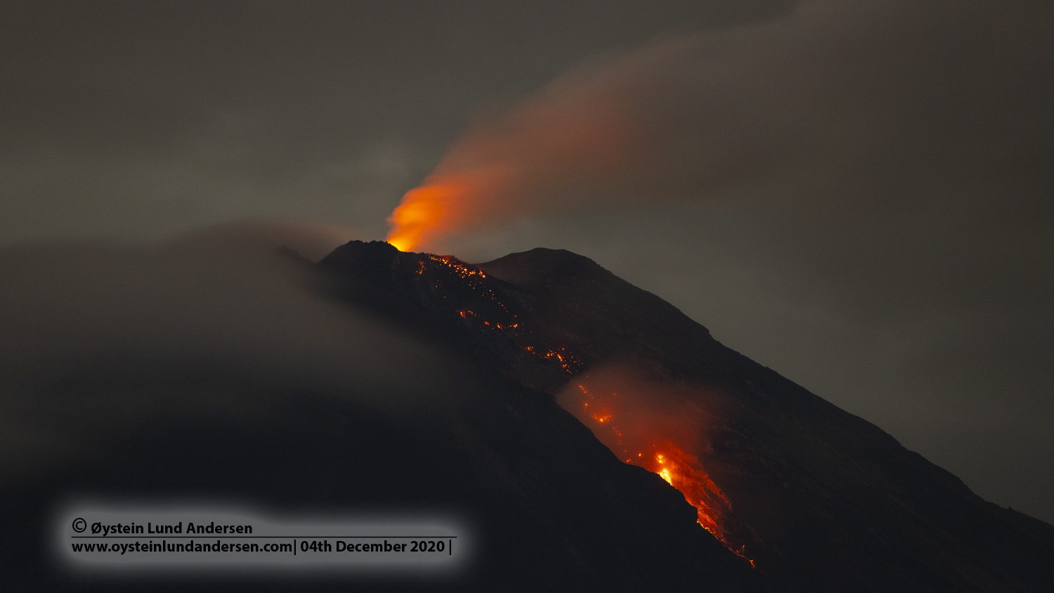
Volcanic Activity Summary :
Eruption with volcanic ash cloud at 06h06 UTC (13h06 local).
Volcanic Cloud Height :
Best estimate of ash-cloud top is around 13363 FT (4176 M) above sea level, may be higher than what can be observed clearly. Source of height data: ground observer.
Other Volcanic Cloud Information :
Ash-cloud moving to southwest.
Source : Magma Indonésie .
Photo : Oystein lund Andersen .
Ecuador , Sangay :
DAILY REPORT OF THE STATE OF SANGAY VOLCANO, Sunday June 05, 2022.
Information Geophysical Institute – EPN.
Surface Activity Level: High, Surface Trend: No change.
Internal activity level: High, Internal trend: No change.
Seismicity: From June 04, 2022, 11:00 a.m. to June 05, 2022, 11:00 a.m.:
Explosion (EXP) 25
Long Periods (LP) 169
Emission tremor (TREMI): 17
Rains / Lahars:
During the afternoon of yesterday, there were rains in the region, the same that generated lahars. **In the event of heavy rains, they could remobilize the accumulated materials, generating mudslides and debris that would descend on the flanks of the volcano and flow into the adjacent rivers.**
Emission / ash column:
Today’s morning cleared up for a moment and an emission of steam and gas from a height of less than 500 meters and heading west was observed. The Washington VAAC published 5 ash emission reports with heights of 570 to 1170 meters above crater level in a west and southwest direction.
Other Monitoring Parameters:
Firms and Mirova systems are not reporting thermal alerts in the last 24 hours.
Observation:
Most of the time, the volcano remains cloudy.
Alert level: Orange.
Source : IGEPN.
Photo : EFE.
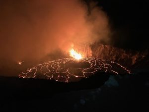
Hawaii , Kilauea :
19°25’16 » N 155°17’13 » W,
Summit Elevation 4091 ft (1247 m)
Current Volcano Alert Level: WATCH
Current Aviation Color Code: ORANGE
Activity Summary:
The summit eruption of Kīlauea Volcano, within Halemaʻumaʻu crater, continued over the past 24 hours. All recent lava activity has been confined to the crater, and current data indicate that this scenario is likely to continue. No significant changes have been noted at summit or in the East Rift Zone.
Halemaʻumaʻu crater Lava Lake Observations:
Eruption of lava from the Halemaʻumaʻu crater western vent into the active lava lake and ooze-outs onto the crater floor have continued over the past 24 hours. The active lava lake has shown continuous surface activity, and while the active lava lake remains below overflow, the active lake level rose 6 meters (20 feet) over the past 24 hours. Minor lava ooze-out activity occurred along the northeastern edge of the crater floor. Overflight measurements on May 10, 2022 indicated that the crater floor had seen a total rise of about 106 meters (348 feet)
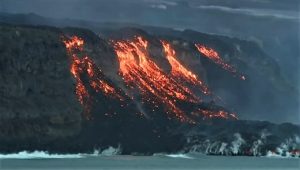
.
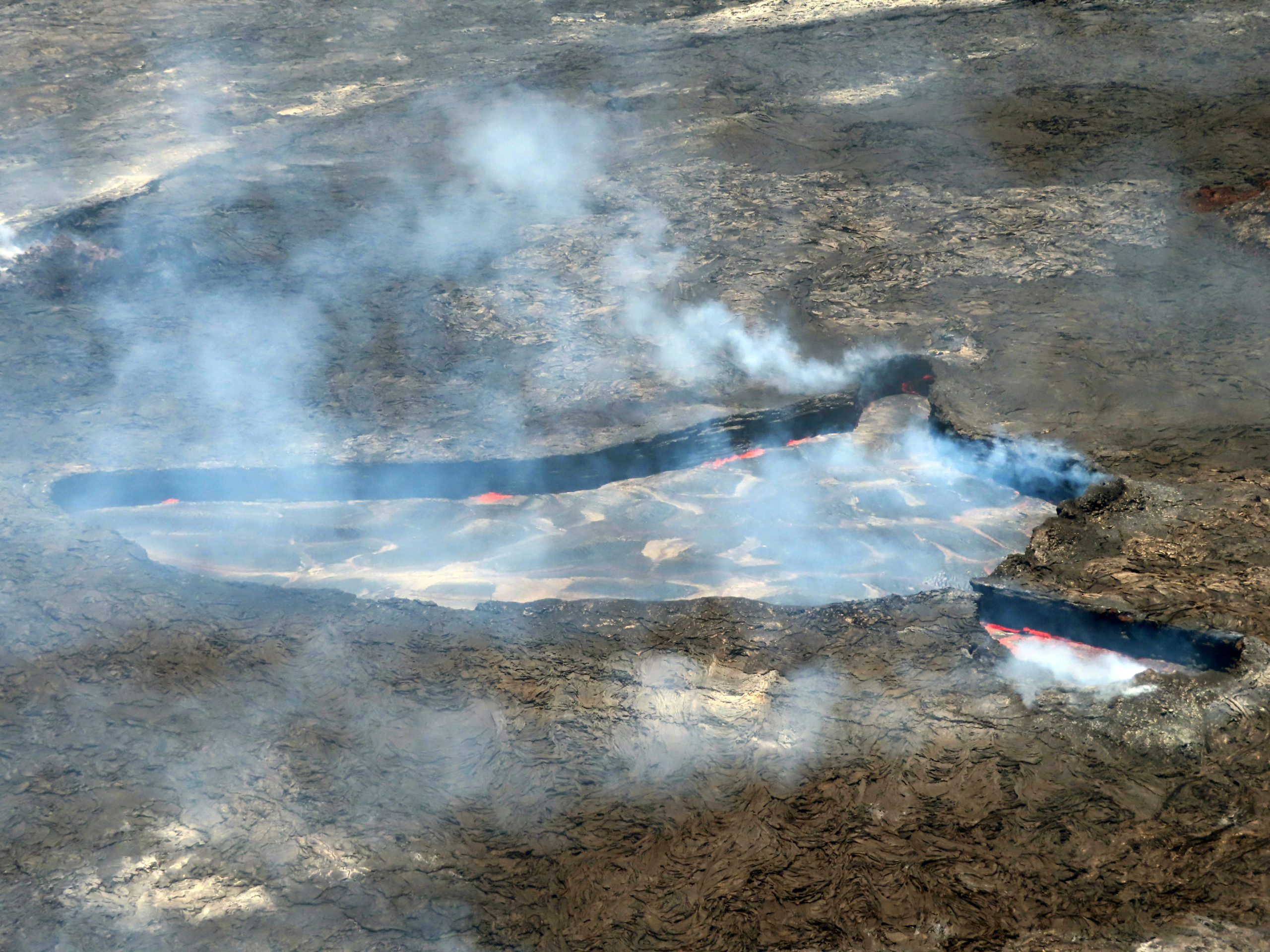
View looking north of the active lava lake within Halema‘uma‘u Crater, at the summit of Kīlauea, during a volcano monitoring field shift on June 2, 2022. Spattering of lava occurred intermittently along the edges of the active lava lake basin, as shown by the orange areas on the north side of the basin. In the southeast lobe (lower right of photo), lava moved rapidly southeastward from the pinched area, through the lobe, and under the hardened crust to the southeast. Occasionally, solidified pieces of crust got stuck in the pinched zone, causing lava to slow. Once the solidified crust dislodged, the speed of the lava increased again.
Summit Observations:
Summit tiltmeters recorded inflation over the past 24 hours. A sulfur dioxide (SO2) emission rate of approximately 2,500 tonnes per day (t/d) was measured on June 2, 2022.
Source : HVO.
Photo : USGS / J.M. Chang.
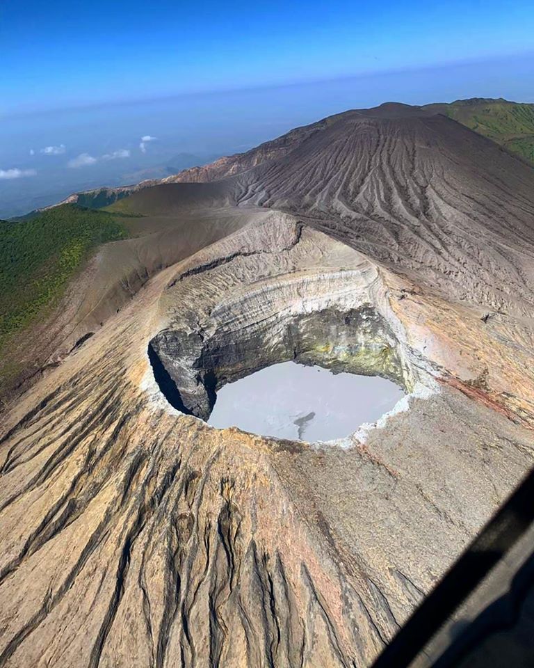
Costa Rica , Rincon de la Vieja :
No eruption was reported.
Seismic activity is similar, compared to yesterday.
At the time of this report, the winds are blowing to the northeast.
A low amplitude probable exhalation signal was recorded at 11:36 p.m. without direct observation due to the night. The tremor became continuous yesterday until this last hour when it started to fragment again.
Source : Ovsicori.
Photo : Christopher Allen