April 28 , 2022.
Indonesia , Anak Krakatau :
PVMBG reported that the eruption at Anak Krakatau had intensified. Dense white, gray, and black ash plumes rose as high as 1 km above the summit and drifted SW during 17-19 April. Strombolian activity was first observed on 17 April; that same day that sulfur dioxide emissions increased to 181.1 tons per days from 28.4-68.4 tons per day recorded during 14-15 April. A dense gray-black ash plume rose around 800 m above the summit at 0621 on 21 April and drifted E. At 0049, 0145, 0237, and 1730 on 22 April dense gray-to-black ash plumes rose 500-1,500 m above the summit and drifted SW.
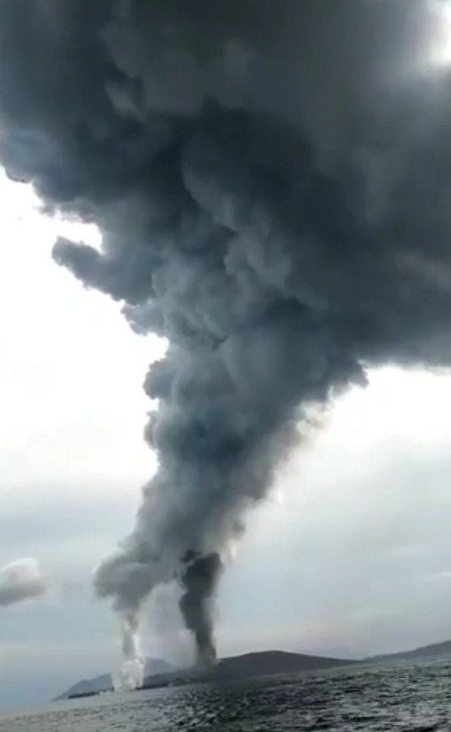
Incandescent material was occasionally ejected above the vent. Sulfur dioxide emissions notably increased to 9,219 tons per day on 23 April. That same day, at around 1219, lava flowed into the sea and produced a white steam plume at the entry point. Ash plumes were taller on 23 April, rising to 3 km above the summit at 0608, 1200, and 2020, with SSW, S, and SE drifts. The plumes continued to be characterized as dense, and white, gray, and black in color. On 24 April PVMBG raised the Alert Level to 3 (on a scale of 1-4), and the public was warned to stay at least 5 km away from the crater.
Source : GVP,
Photo : Pasek Made.
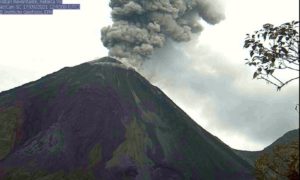
Kamchatka , Karymsky :
VOLCANO OBSERVATORY NOTICE FOR AVIATION (VONA)
Issued: April 28 , 2022.
Volcano: Karymsky (CAVW #300130)
Current aviation colour code: ORANGE
Previous aviation colour code: red
Source: KVERT
Notice Number: 2022-30
Volcano Location: N 54 deg 2 min E 159 deg 26 min
Area: Kamchatka, Russia
Summit Elevation: 1486 m (4874.08 ft)
Volcanic Activity Summary:
The emission of ash from the volcano has ended, but the ash cloud 28×34 km in size on the height 9 km a.s.l. continues to move to the west-northwest of the volcano; at 03:50 UTC the ash cloud was 289 km from the volcano.
A moderate activity of the volcano continues. Ash explosions up to 12 km (39,400 ft) a.s.l. could occur at any time. Ongoing activity could affect international and low-flying aircraft.
Volcanic cloud height:
NO ASH CLOUD PRODUSED
Other volcanic cloud information:
NO ASH CLOUD PRODUSED
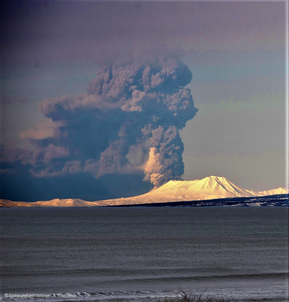
KVERT reported that a thermal anomaly over Karymsky was visible in satellite images during 15-22 April. Explosions during 17-19 and 21 April generated ash plumes that rose as high as 7.5 km (24,600 ft) a.s.l. and drifted 500 km NE. SE, and E. A powerful explosion at 0805 on 20 April (local time) generated ash plumes that rose as high as 11 km (36,100 ft) a.s.l. and drifted more than 2,000 km NE. KVERT raised the Aviation Color Code to Red (the highest level on a four-color scale). Ashfall was reported in the territory of the Kronotsky Reserve (Semyachinsky, Valley of Geysers), 50 km NE, and at Cape Nalychevo, 100 km S. Explosions continued through the day; ash plumes rising to 5 km (16,400 ft) a.s.l. were visible in satellite images at 1500, local time. The previous ash plume was about 505 x 130 km and drifted NE, S, and SE at an altitude of 8.7 km (28,500 ft) a.s.l. The Aviation Color Code was lowered to Orange by 1544, local time, on 20 April.
28/04 : the Karymsky volcano threw up a column of ash 10 kilometers high. As a result, an ash cloud measuring 5 by 7 kilometers was formed, which is moving across the Sea of Okhotsk to the north of the Khabarovsk Territory.
Source : Kvert , GVP. eastrussia.ru
Photo : A. Eliseeva, Kronotsky Reserve ( 19/04/2022)
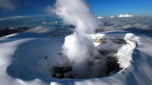
Hawaii , Kilauea :
19°25’16 » N 155°17’13 » W,
Summit Elevation 4091 ft (1247 m)
Current Volcano Alert Level: WATCH
Current Aviation Color Code: ORANGE
Activity Summary:
The summit eruption of Kīlauea Volcano, within Halemaʻumaʻu crater, continued over the past 24 hours. All recent activity has been confined to the crater and current data indicate that this scenario is likely to continue. No significant changes have been noted in the summit or East Rift Zone.
Halemaʻumaʻu crater Lava Lake Observations:
Eruption of lava from the western vent into the active lava lake and onto the crater floor continued over the past 24 hours. The active part of the lava lake showed continuous surface activity. The lake level fluctuated slightly throughout the day, with increased roiling and spattering in the southeast portion of the lake starting yesterday morning. Sporadic breakouts also continue along the margins of the crater, particularly to the east during the past 24 hours. Since the beginning of this eruption on September 29, 2021, the crater floor has seen a total rise of about 99 meters (325 feet). The volume of lava effused since the beginning of this eruption was approximately 66 million cubic meters (18 billion gallons) as measured on April 6, 2022.
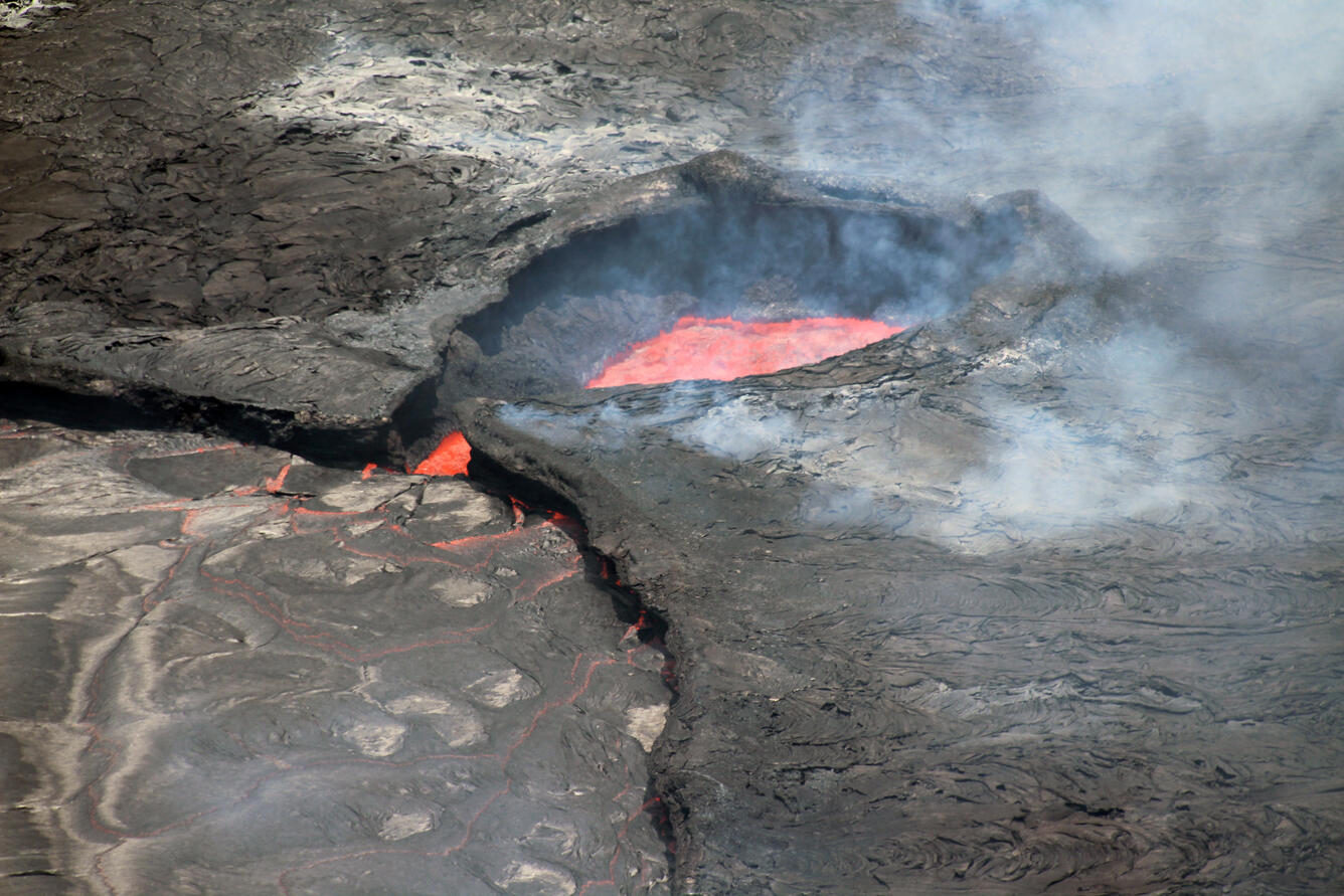
Telephoto view looking east of the southeast embayment of the active lava lake within Halema‘uma‘u, Kīlauea, on April 26 2022. In this photo, lava from the active lava lake (silvery grey surface in lower left quadrant of photo) cascades into the southeast embayment (red surface). As the lava surface within the southeast embayment was constant during the several hour observation period, it appears that from the southeast embayment lava is plunging underneath the crater floor, contributing to the gradual rise of the crater floor surface.
Summit Observations:
Summit tiltmeters have continued to be steady over the past day. Volcanic tremor remains above background levels. A sulfur dioxide (SO2) emission rate of approximately 2,800 tonnes per day (t/d) was measured on April 25, 2022.
Source : HVO.
Photo : USGS / N. Deligne.
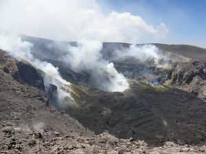
Japan , Sakurajima :
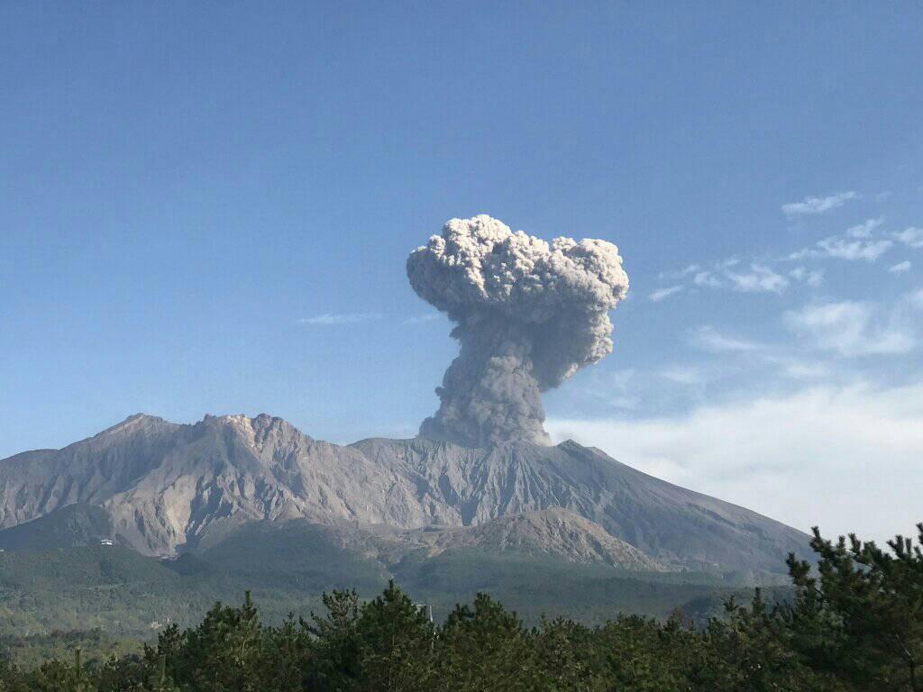
JMA reported that very small eruptive events at Minamidake Crater (at Aira Caldera’s Sakurajima volcano) were recorded during 18-25 April. Crater incandescence was periodically visible at night. The sulfur dioxide emissions were slightly high at 1,300 tons per day on 19 April but then dropped to 500 tons per day on 22 April. The Alert Level remained at 3 (on a 5-level scale), and residents were warned to stay 2 km away from the crater.
The Aira caldera in the northern half of Kagoshima Bay contains the post-caldera Sakurajima volcano, one of Japan’s most active. Eruption of the voluminous Ito pyroclastic flow accompanied formation of the 17 x 23 km caldera about 22,000 years ago. The smaller Wakamiko caldera was formed during the early Holocene in the NE corner of the Aira caldera, along with several post-caldera cones. The construction of Sakurajima began about 13,000 years ago on the southern rim of Aira caldera and built an island that was finally joined to the Osumi Peninsula during the major explosive and effusive eruption of 1914. Activity at the Kitadake summit cone ended about 4850 years ago, after which eruptions took place at Minamidake. Frequent historical eruptions, recorded since the 8th century, have deposited ash on Kagoshima, one of Kyushu’s largest cities, located across Kagoshima Bay only 8 km from the summit. The largest historical eruption took place during 1471-76.
Source : GVP.
Photo : Rizal M. (archive).
Vanuatu , Ambrym :
AMBRYM VOLCANO ALERT BULLETIN N05 was issued by the Vanuatu Meteorology and Geohazards Department on 28th April 2022 at 11:52 am:
Ambrym volcano has now moved from the major unrest state to the minor unrest state. The Volcanic Alert Level is lowered from Level 2 to Level 1.
The volcano activity on Ambrym has substantially decreased after the significant increase on its activity on Benbow crater at the end of January 2022. Since early February 2022, the lava glow has disappeared on Benbow crater and the volcano seismicity has decreased and is now stable .
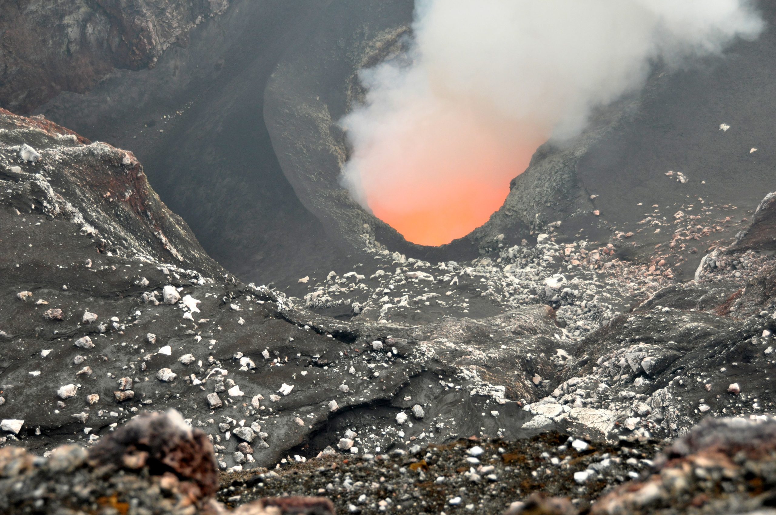
Latest observations and daily analysis of the Ambrym seismic data from the volcano monitoring system confirm that the Ambrym volcano especially Benbow crater is no longer emitting gas and/or ash plumes since early February of this year 2022.
The volcanic hazards still present on Ambrym, specifically at the summit and eastern part of the Island. These are related to the presence of cracked areas. In addition to the summit hazards, the presence of active rifts and faults (major ground cracking) at the South-East area of Ambrym are also hazardous, they will continue to be eroded and affected by earthquake activity.
Source : Geohazard.
Photo : G Vitton. ( Bembow , 2011)