December 31 , 2021.
La Réunion Island , Piton de la Fournaise :
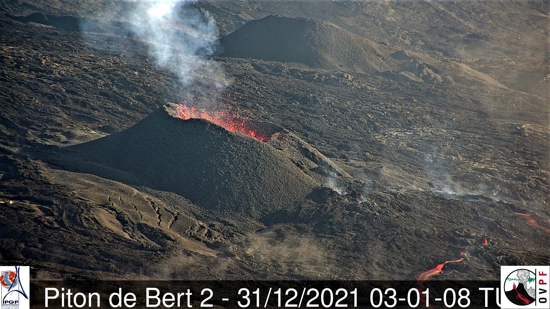
Press release of December 31, 2021 – 11:30 a.m.
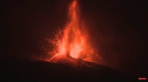
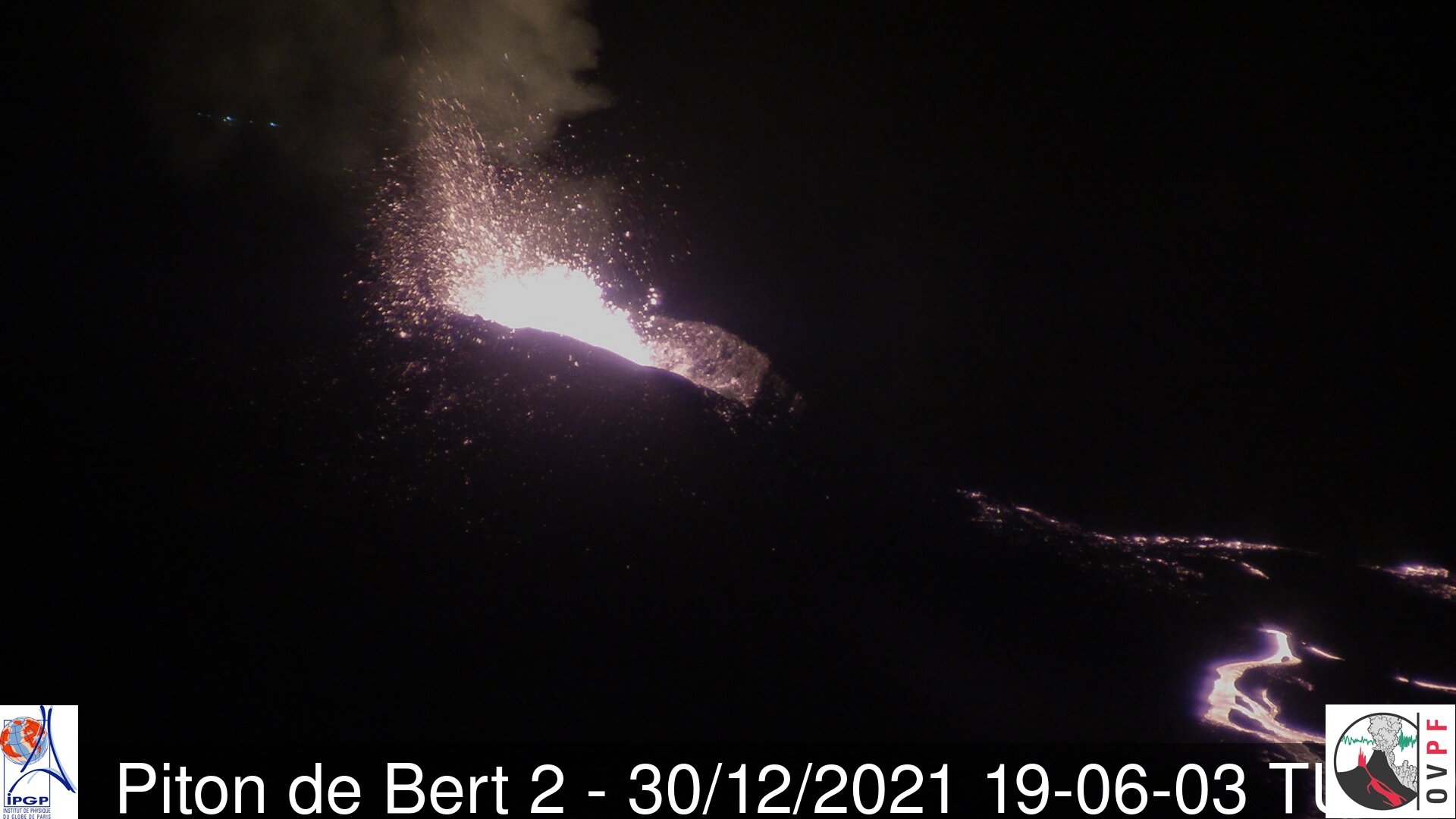
The eruption that began on December 22, 2021 at around 3:30 a.m. local time continues. Over the last 24 hours the amplitude of the eruptive tremor (indicator of an emission of lava on the surface) still shows fluctuations. The fluctuations observed can be linked either to:
– the cone under construction which undergoes construction and dismantling phases, thus influencing the speed of the lava flows at the level of the vent;
– or to punctual releases of pockets of gas trapped in the supply ducts which can be released suddenly leading to an increase in the tremor.
The average amplitude of the tremor is this morning at about 50% of its initial amplitude.
The bad weather conditions on the volcano still make it difficult to observe the eruption. However, thanks to the clearings at the end of the day yesterday and at the beginning of
Today morning observations could be made. These latest observations still show lava fountain activity within the cone that has built up since the start of the eruption. Videos from the OVPF-IPGP-IRT webcams last night show slightly more intense activity than the past few days with lava fountains exceeding the height of the cone. Numerous resurgences of lava flows were visible on the roof of the lava tunnel that developed downstream from the cone.
Over the last 24 hours:
– A single volcano-tectonic earthquake of low magnitude (<0.5) was recorded under the summit.
– The surface deformations show a slight deflation at the level of the summit zone, linked to the emptying of the magma reservoir located under the summit (at about 2-2.5 km deep) and
feeding the eruptive site.
– The CO2 concentrations in the soil in the Gîte du volcan sector have been increasing for several days. This parameter will be monitored over the next few days as it may be linked to the arrival
new magma, coming from deeper areas, at the level of the shallow reservoir.
– Thanks to more favorable weather conditions last night at the eruptive site, lava flows were estimated by satellite method with the HOTVOLC platform (OPGC –
Clermont Auvergne University). They were between 2.3 and 9 m3 / sec last night. These variations are explained by the method, which is based on the infrared radiation of the casting, whose
Satellite perception can be greatly influenced by the weather conditions above the lava flows.
Due to the poor weather conditions at the site this morning, no assessment of the position of the flow front could be made.
Alert level: Alert 2-1 (eruption in the Enclos )
Source et photos : OVPF / IPGP .
Alaska , Davidof :
VOLCANO OBSERVATORY NOTICE FOR AVIATION (VONA)
Issued: December 29 , 2021.
Volcano: Davidof (VNUM #311040)
Current Color Code: UNASSIGNED
Previous Color Code: YELLOW
Source: Alaska Volcano Observatory
Notice Number: 2021/A1184
Volcano Location: N 51 deg 57 min E 178 deg 19 min
Area: Aleutians
Summit Elevation: 1076 ft (328 m)
Volcanic Activity Summary:
The swarm of earthquakes that occurred in the vicinity of Davidof volcano beginning in early December has subsided. Thus, the Aviation Color Code and Alert Level is being decreased to UNASSIGNED/UNASSIGNED. AVO only assigns color code and alert level values to volcanoes that are sufficiently instrumented to allow us to understand the background state of activity. The closest seismometers to Davidof are approximately 15 km to the east of the volcano on Little Sitkin Island, and are insufficient to allow us to assign specific alert levels. Thus, UNASSIGNED is used.
Davidof and Segula islands viewed from the west side of Little Sitkin.
Volcanic cloud height: n/a
Other volcanic cloud information: Unknown
Remarks:
Davidof volcano is a mostly submerged stratovolcano in the Rat Islands group in the western Aleutian Islands, about 350 km west of Adak. The subaerial part of the volcano comprises Davidof, Khvostof, Pyramid, and Lopy islands, which encircle Crater Bay, a 2.5 km diameter caldera. The islands are built up from interbedded lava flows and explosive deposits. The volcano has been sparsely studied, but visits by Alaska Volcano Observatory geologists in 2021 documented thick sequences of rhyolite to dacite pyroclastic flow and fall deposits that represent the most recent explosive eruptions. The age of these deposits is unknown, but they appear older than Holocene deposits from nearby Segula and Little Sitkin. There are no known historical eruptions from Davidof.
Source : AVO.
Photo : Loewen, Matt / Alaska Volcano Observatory / U.S. Geological Survey
Hawaii , Kilauea :
19°25’16 » N 155°17’13 » W,
Summit Elevation 4091 ft (1247 m)
Current Volcano Alert Level: WATCH
Current Aviation Color Code: ORANGE
Activity Summary:
Kīlauea Volcano is erupting, but at a diminished rate, from a single vent near the western wall of Halemaʻumaʻu crater, in the volcano’s summit region and within Hawai‘i Volcanoes National Park. All recent lava activity has been confined to the crater, and there are no indications of activity migrating elsewhere on Kīlauea.
Summit Observations:
Summit tiltmeters have been tracking rapid deflation since 3 AM this morning. Volcanic tremor associated with the eruption—as recorded by nearby seismometers—began to decrease around 6 AM and is continuing at low levels. Earthquake activity in the summit region remains below background level. A sulfur dioxide (SO2) emission rate of approximately 5,000 tonnes per day was measured yesterday in the summit region while the lava lake was very active.
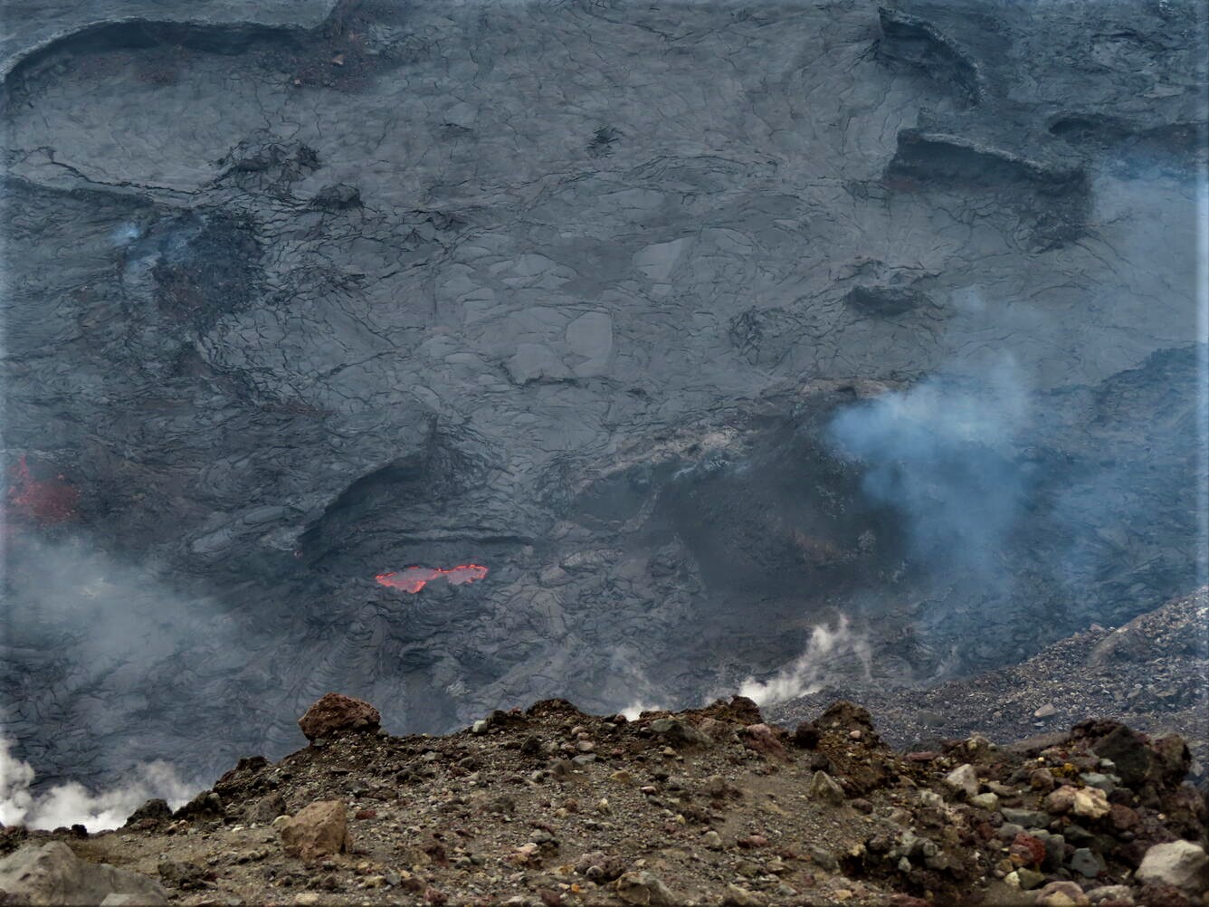
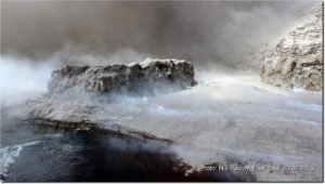
On the afternoon of December 27, 2021, the summit eruption of Kīlauea was paused and showed only intermittent and weak crustal foundering in the formerly active west side of the lava lake in Halema‘uma‘u. This photo, looking down and toward the east, shows the topography of the formerly active pond of lava during the eruption pause. The pond surface is approximately 12 meters (39 feet) lower than the high ledges surrounding it.
Halemaʻumaʻu Lava Lake Observations:
Diminished effusion of lava from the western vent in Halemaʻumaʻu into the active lava lake is indicated by formation of cooler crust on the outer half of the lake and decreasing lava velocities measured on the thermal camera. No overflows from the active lake have been observed in the past 24 hours, but there have been several lava ooze-outs along the margins of the crusted-over northern and eastern portion of the lake, including one onto the lowermost down-dropped block from the 2018 caldera collapse. These ooze-outs provide evidence of continued supply of molten lava below the stagnant lake crust in this area. The lake has seen a total rise of about 70 meters (230 feet) since lava emerged on September 29. Measurements from a helicopter overflight on December 21 indicated that the total lava volume effused since the beginning of the eruption was approximately 38 million cubic meters (10.0 billion gallons) at that time.
Source : HVO.
Photo : USGS / K. Lynn .
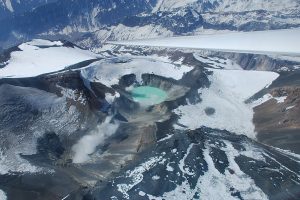
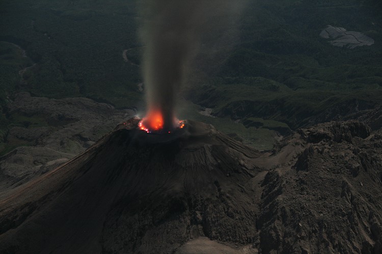
Kamchatka , Sheveluch :
56.64 N, 161.32 E;
Elevation 3283 m (10768 ft), the dome elevation ~2500 m (8200 ft)
Aviation Colour Code is ORANGE
The extrusive eruption of the volcano continues. Ash explosions up to 10-15 km (32,800-49,200 ft) a.s.l. could occur at any time. Ongoing activity could affect international and low-flying aircraft.
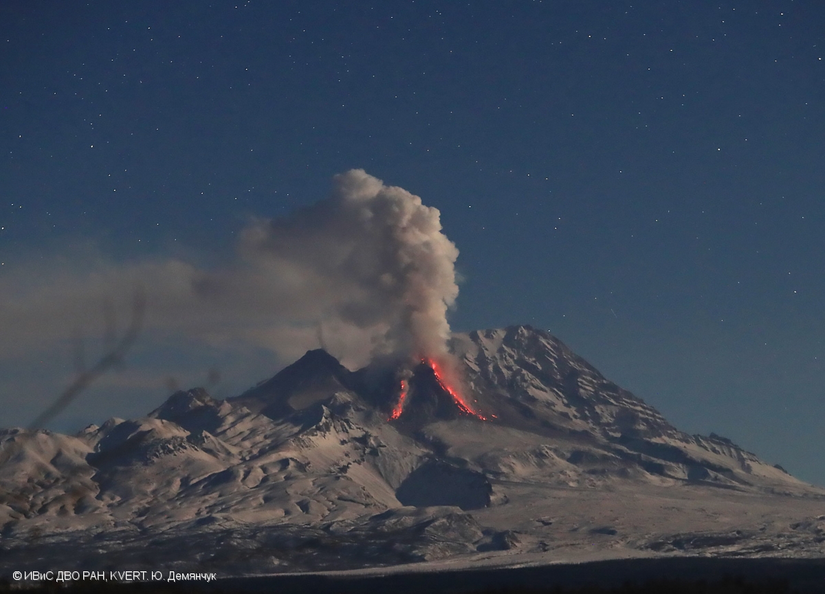
A growth of the lava dome continues, a strong fumarolic activity, and an incandescence of the lava dome, and hot avalanches accompanies this process. Satellite data by KVERT showed: along with powerful gas-steam activity, ash removal up to 4.5 km a.s.l. was noted on 24-25, 27, and 30 December, such plumes extended for 110 km in the northwestern and northeastern directions from the volcano; a thermal anomaly over the volcano was noted all week.
Source : Kvert.
Photo : Yu. Demyanchuk. IVS FEB RAS, KVERT ( archive 2019).
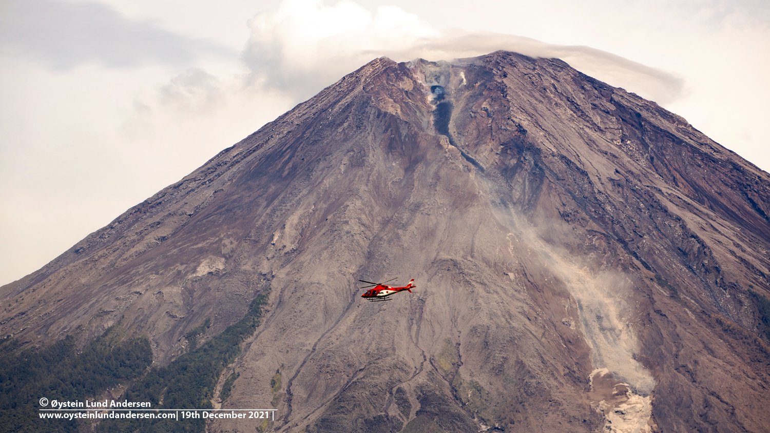
Indonesia , Semeru :
VOLCANO OBSERVATORY NOTICE FOR AVIATION – VONA
Issued : December 30 , 2021
Volcano : Semeru (263300)
Current Aviation Colour Code : ORANGE
Previous Aviation Colour Code : orange
Source : Semeru Volcano Observatory
Notice Number : 2021SMR92
Volcano Location : S 08 deg 06 min 29 sec E 112 deg 55 min 12 sec
Area : East java, Indonesia
Summit Elevation : 11763 FT (3676 M)
Volcanic Activity Summary :
Pyroclastic flow occured from the edge of lava deposit at 21h31 UTC ( 04h31 local )
Volcanic Cloud Height :
Best estimate of ash-cloud top is around 18163 FT (5676 M) above sea level, may be higher than what can be observed clearly. Source of height data: ground observer.
Other Volcanic Cloud Information :
Ash-cloud moving to north
Remarks :
Lava flow is observed through the North direction of the Semeru summit crater.
Source : Magma Indonesia .
Photo : Oystein Lund Andersen .
Guatemala , Santiaguito :
Activity:
The observatory of the Santiaguito volcano OVSAN reports a white and gray degassing 500 meters above the crater which disperses in a West and South-West direction. Weak and moderate explosions were recorded which emit white and gray columns at a height of up to 3,400 meters above sea level (11,155 feet). ) which are scattered in a west and south-west direction. At night and early in the morning, a permanent incandescence was observed on the Caliente dome.
It continues to generate constant, moderate to strong avalanches of boulders and ash on the flanks: West, Southwest and South mainly and others weak to moderate in the Northeast and Southeast direction, several of between them reaching the base of the Caliente Dome. Some explosions and avalanches leave fine ash suspended in the volcanic perimeter with probabilities of ash fall in communities to the west and southwest of the volcano. The volcano maintains high activity due to the extrusion of blocky lava from the Caliente Dome in a West-South-West direction. Materials are unstable in the crater and there is the likelihood of moderate to strong pyroclastic flows. You should therefore not stay near or in the river beds near the slopes of the volcano.
Source : Insivumeh.
Photo : Marcszeglat , 2009 , wikimedia