December 26 , 2021.
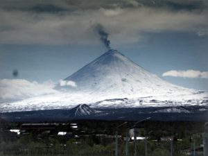
La Réunion , Piton de la Fournaise :
Press release of December 26,2021 – 11:45 a.m.
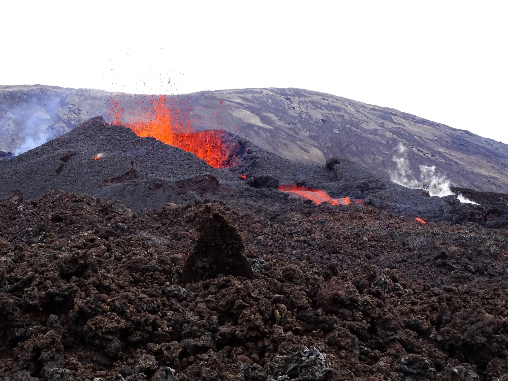
The eruption that began on 12/22/2021 at around 3:30 a.m. local time continues. Over the last 24 hours the amplitude of the eruptive tremor (indicator of an emission of lava on the surface) shows fluctuations. These fluctuations can be linked either to:
– the cone under construction which undergoes construction and dismantling phases, thus influencing the speed of the lava flows at the level of the vent;
– or to punctual releases of pockets of gas trapped in the supply ducts which can be released suddenly leading to an increase in the tremor.
The amplitude of the tremor is this morning (on average over the last half-day) at about 30% of its initial amplitude.
The lava tunnels which had been set up at the foot of the cone from 12/23/2021 thanks to the closure of the cone, broke at the end of the night, and the flow can again be observed at the foot of the eruptive cone.
No on-site observations could be made today.
Over the last 24 hours:
– No volcano-tectonic earthquake was recorded.
– The surface deformations show a slight deflation at the level of the summit zone, linked to the emptying of the magma reservoir located under the summit (at about 2-2.5 km deep) feeding the eruptive site.
– The lava flow estimates, established by satellite method with the HOTVOLC platform (OPGC – Clermont Auvergne University), are between 2 and 27 m3 / sec, with an average of 5 m3 / sec.
As a reminder, this method is based on the infrared radiation of the flow, the perception of which by the satellites, perhaps largely influenced by the atmospheric conditions above the flows.
– The front of the flow, in graton, currently on a relatively flat area, moves only very slowly.
Alert level: Alert 2-1 (eruption in the Enclos )
Source et photo : OVPF.
Spain / La Palma , Cumbre Vieja :
December 25, 2021 3:00 p.m. UTC. The eruption of Cumbre Vieja ended on December 13, 2021.
The observations, both direct on the surface and from the surveillance systems, corroborate the exhaustion of the eruptive process which began on September 19, 2021 at 2:11 p.m. UTC, ending on December 13, 2021 at 10:21 p.m. UTC, thus lasting 85 days and 8 hours. Its typology was a Strombolian fissure eruption with phreato-magmatic impulses. The end of the eruption should not imply the end of certain dangers linked to the volcanic phenomenon, nor necessarily the end of the magmatic reactivation of Cumbre Vieja.
Seismicity, which is of low magnitude, is at very low levels at all depths. Despite the current level of seismicity, the occurrence of felt earthquakes is not excluded. There is no presence of volcanic tremor in the seismic signals.
Concerning the deformations, they remain without tendency in all the stations of the network.
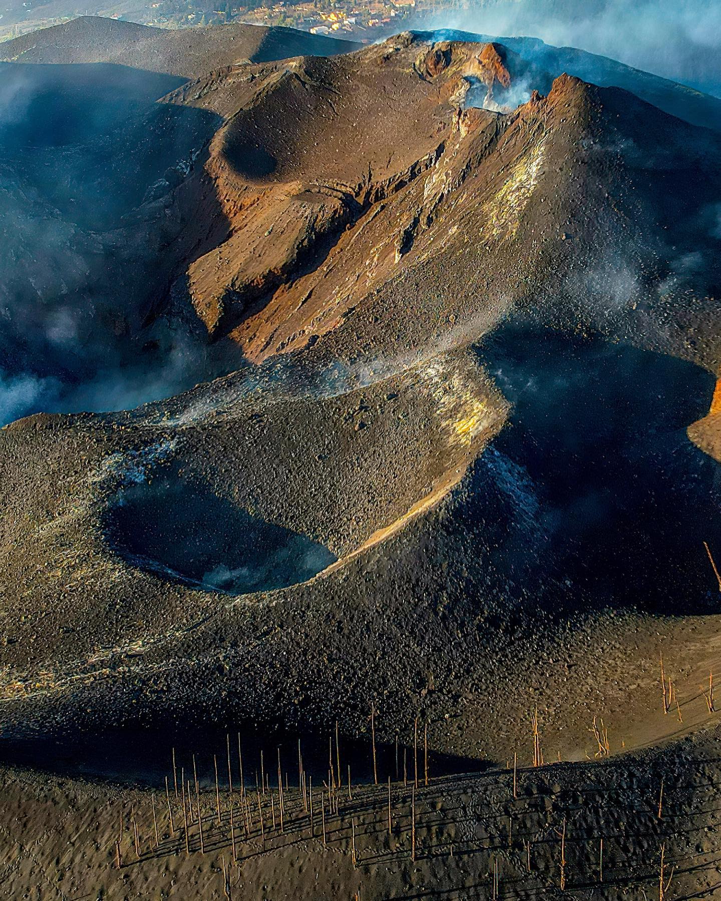
During this eruption a volcanic cone was built, the highest point of which is located at an altitude of 1,121 m above sea level, rising to about 200 m above the pre-eruptive topography. The estimated volume of the eruptive cone built is 34 Mm3 and the estimate of the total volume of volcanic material emitted exceeds 200 Mm3.
The maximum height of the eruptive column was reached on December 13, which measured 8,500 meters above sea level.
9,090 earthquakes were located, 5.1 mbLg being the maximum magnitude recorded and IV-V the highest intensity reached on the EMS scale. The seismic energy released accumulated during the process is 6.3 * 1013 Joules. The maximum deformation recorded at the Earth’s surface was recorded on October 24 at station LP03 and was 33 cm vertically..
Source : IGN es.
Photo : I love the world.
Hawaii , Kilauea :
19°25’16 » N 155°17’13 » W,
Summit Elevation 4091 ft (1247 m)
Current Volcano Alert Level: WATCH
Current Aviation Color Code: ORANGE
Activity Summary:
Kīlauea Volcano is erupting from a single vent near the western wall of Halemaʻumaʻu crater, in the volcano’s summit region and within Hawai‘i Volcanoes National Park. The vent is supplying an active lava lake in the western portion of Halemaʻumaʻu. All recent lava activity has been confined to the crater, and there are no indications of activity migrating elsewhere on Kīlauea.
Summit Observations:
Summit tiltmeters have been tracking deflation since the resumption of the eruption in the evening of December 22, although the rate of deflation has been slowing over the past 24 hours. Volcanic tremor associated with the eruption—as recorded by nearby seismometers—remains stable, and earthquake activity in the summit region remains below background level. A sulfur dioxide (SO2) emission rate of approximately 130 tonnes per day was measured on December 21 during the most recent eruptive pause. In comparison, the measured rate when eruptive activity was more vigorous was about 1,400 tonnes per day on December 16.
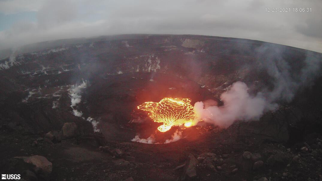
Halemaʻumaʻu Lava Lake Observations:
Lava continues effusing from the western vent in Halemaʻumaʻu into the active lava lake that occupies the western portion of the crater. Throughout the day yesterday, lava overflowed onto inactive, crusted portions of the lake several times, but this activity ceased around midnight and no substantial overflows have been recorded in webcam views since then. The lake has seen a total rise of about 69 meters (226 feet) since lava emerged on September 29. Measurements from a helicopter overflight on December 21 indicated that the total lava volume effused since the beginning of the eruption was approximately 38 million cubic meters (10.0 billion gallons) at that time.
The U.S. Geological Survey’s Hawaiian Volcano Observatory (HVO) recorded a magnitude-4.9 earthquake located on Kamaʻehuakanaloa (Lō‘ihi) volcano, south of the Island of Hawai‘i on Friday, December 24, at 01:32 a.m. HST. The earthquake was centered about 42 km (26 miles) southeast of Nā‘ālehu, at a depth of 12 km (7.5 miles).
Source et photo : HVO
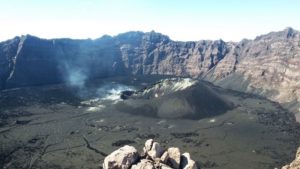
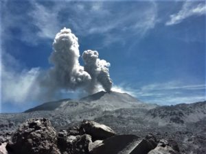
Chile , Nevados de Chillan :
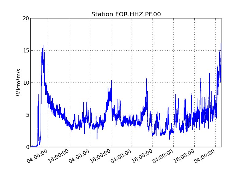
The seismicity parameters associated with the fracturing processes of rigid materials (type VT) recorded a marked decrease in the number of events and a slight decrease in their associated energy, while the events associated with fluid dynamics (types LP and VLP ) also saw a decrease in the number of events maintaining energy levels similar to the previous period. In turn, a decrease in tremor pulses (TR) was observed, while the number of explosive events (EX) was maintained for the period.
The highest energy VT-type event, with a local magnitude (ML) of 2.6, was located 1.7 km east-southeast (ESE) of the active crater and at a depth of 3 km.
From the analysis of the images provided by the surveillance cameras belonging to OVDAS as well as the satellite images, only an advance was observed for the « L7 » flow in its central channel and its second lobe. However, as of December 13 and to this day, no advance of flows has been observed, as well as no radiation on them.
The explosive activity exhibited during the period evaluated a higher surface energy during the first days of the month, which decreased with the days. The explosions were characterized by columns with moderate pyroclastic content in their initial phase and greater water vapor richness in their final phase. 60% of the recorded explosions occurred with heights less than 300 m, while the maximum estimated height was 1,660 m above the level of the crater.
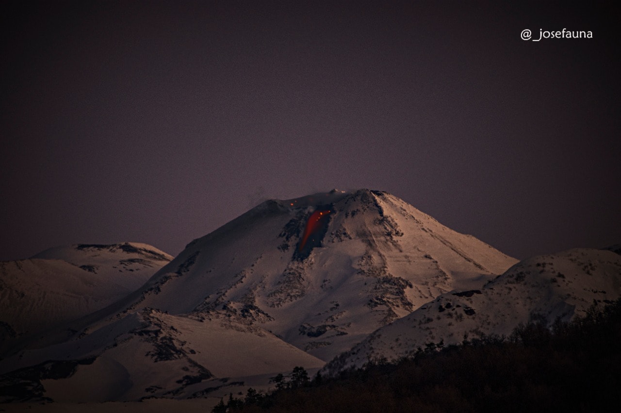
Episodes of greater nocturnal incandescence occurred on December 7 and 11, which caused the detachment of fragments with a radial distribution not exceeding 600 m from the emission center.
According to the data obtained by the network of GNSS stations installed on the volcano, we observe the passage from a phase of inflation to deflation, with stations recording a shortening of -0.7 cm / month, while vertical components record maximum slump rates of -0.6 cm / month.
Fifteen (15) thermal alerts were recorded in the area with a maximum value of 98 MW on December 11, a value considered high for this volcano.
DOAS gas measurement equipment recorded a maximum sulfur dioxide (SO2) emission value of 473 t / d corresponding to December 2, while the recorded average emission was 236 t / d, proof of a continuous decrease in gas emissions compared to the previous period, probably linked to a partial obstruction of the emission ducts.
Source : Segemar.
Photo : josefauna
Alaska , Pavlof :
55°25’2″ N 161°53’37 » W,
Summit Elevation 8261 ft (2518 m)
Current Volcano Alert Level: WATCH
Current Aviation Color Code: ORANGE
The eruption of Pavlof Volcano continues. Strongly elevated surface temperatures corresponding to the lava flow on the eastern flank were observed in satellite data throughout the week. Low-level ash emissions were observed in web camera views of the volcano on two days last week. Elevated seismicity, consisting of periods of sustained tremor and discrete low-frequency events, was detected throughout the past week. Small explosions were detected in seismic and infrasound data on most days.
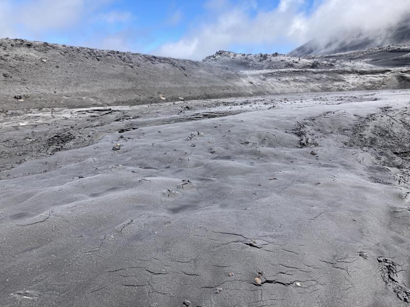
A thin lahar deposit on top of a snow field on the southwest flank of Mount Cerberus. Gray ash covers the nearby lava flows from North Cerberus.
Periods of lava fountaining from the vent on the volcano’s upper southeast flank have been occurring since mid-November. This activity has built a small cone and sent flows down the flank that melt the snow and ice and can produce variable amounts of meltwater. The meltwater typically incorporates loose debris on the flank of the volcano and forms lahars. The lahar deposits observed so far appear relatively thin (<2 m thick) and were likely emplaced by water-rich flows. The lahar deposits extend down the east-southeast flank for several kilometers, not quite to the base of the volcano.
Previous eruptions of Pavlof indicate that the level of unrest can change quickly and the progression to more significant eruptive activity can occur with little or no warning.
Pavlof is monitored by local seismic and infrasound sensors, satellite data, web cameras, and remote infrasound and lightning networks.

Pavlof Volcano is a snow- and ice-covered stratovolcano located on the southwestern end of the Alaska Peninsula about 953 km (592 mi) southwest of Anchorage. The volcano is about 7 km (4.4 mi) in diameter and has active vents on the north and east sides close to the summit. With over 40 historic eruptions, it is one of the most consistently active volcanoes in the Aleutian arc. Eruptive activity is generally characterized by sporadic Strombolian lava fountaining continuing for a several-month period. Ash plumes as high as 49,000 ft above sea level have been generated by past eruptions of Pavlof, and during the March 2016 eruption, ash plumes as high as 40,000 ft above sea level were generated and the ash was tracked in satellite data as distant as eastern Canada. The nearest community, King Cove, is located 48 km (30 miles) to the southwest of Pavlof.
Source : AVO
Photos : Dietterich, Hannah / Alaska Volcano Observatory / U.S. Geological Survey , Loewen, Matt / Alaska Volcano Observatory / U.S. Geological Survey.