December 25 , 2021.
Iceland , Reykjanes Peninsula :
Strong earthquake activity in Fagradalsfjall mountain, Krýsuvík-Trölladyngja volcano
There is now a constant earthquake swarm activity in Fagradalsfjall mountain, part of the Krýsuvík-Trölladyngja volcano system. More than a dozen of earthquakes have been larger than magnitude 4,0 and it doesn’t look like this earthquake activity is doing to stop soon. Largest earthquakes in last few hours had a magnitude of Mw4,8 and Mw4,5. The earthquake north of Grindavík town appears to be a tension breaking earthquakes because of magma inflation in Fagradalsfjall mountain.
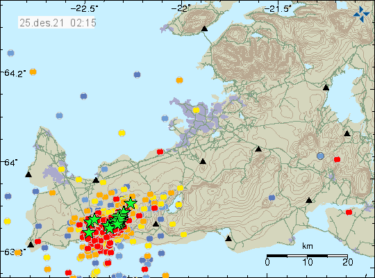
A lot of earthquakes on Reykjanes peninsula, more than a dozen green stars, hundres of red dots showing smaller earthquakes

This earthquake swarm is close to Grindavík town, this is a similar situation that happened earlier in the year 2021. Just before the eruption in Fagradalsfjall mountain. This earthquake activity is going to continue to grow until an eruption starts. This earthquake activity also happens in a wave, resulting in it lower earthquake activity between powerful earthquake activity. I am expecting more strong earthquakes in next few days, unless an eruption starts in Fagradalsfjall mountain or nearby area.
At 7:25 an M4.2 earthquake occurred a km S of Fagradalsfjall and it was felt widely in SW-part of ICeland. Around 1200 earthquakes have occurred so far today but 3600 were detected yesterday, thereof seven M4.0 or larger. No signs of volcanic tremor.
The 21st of December an earthquake swarm started by Fagradalsfjall volcano, since then around 12000 earthquakes have been automatically detected, thereof 14 larger than M4.0. The largest earthquake was a M4.9 the morning of 22nd of December and was felt in SW Iceland.
Source : icelandgeology.net , vedur is
Photos : Icelandic Met Office.
La Réunion , Piton de la Fournaise :
Press release of December 25, 2021 – 9.45 a.m.
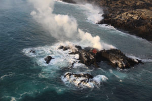
The eruption that began on 12/22/2021 at around 3:30 a.m. local time continues. Over the last 24 hours the amplitude of the eruptive tremor (indicator of an emission of lava on the surface) shows fluctuations. These fluctuations can be linked either to:
– the cone under construction which undergoes construction and dismantling phases, thus influencing the speed of the lava flows at the level of the vent;
– or to punctual releases of pockets of gas trapped in the supply ducts which can be released suddenly, resulting in an increase in the tremor with a certain
periodicity.
The amplitude of the tremor is this morning at about 20% of its initial amplitude.
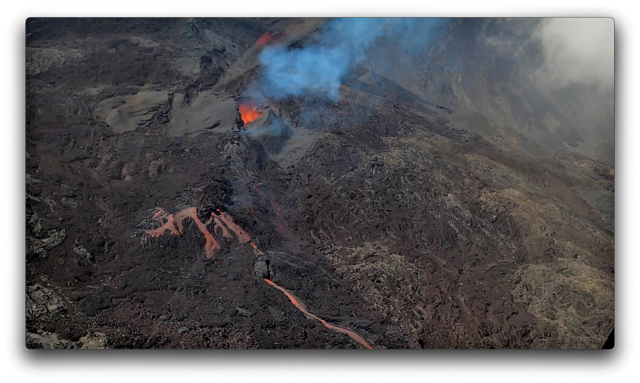
Since the evening of December 23, 2021, thanks to the closure of the eruptive cone, activity in lava tunnels has taken place at the foot of the cone. These tunnels extend over a hundred meters in length before the flow emerges into a single channel further downstream.
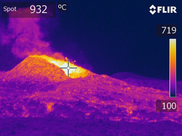
A field mission carried out yesterday afternoon by a team from the OVPF-IPGP made it possible to carry out new samples of the lava flow and to carry out thermal images
on the site . Field observations show that the lava fountain regime within the cone, although still active, is weak and the lava fountains exceed the height of the cone (<15 m) only intermittently.
Over the last 24 hours:
– A single superficial earthquake, of low magnitude (<0.5), was recorded directly above the summit.
– The surface deformations show a slight deflation at the level of the summit area, linked to the emptying of the magma reservoir located under the summit (at about 2-2.5 km depth)
feeding the eruptive site.
– The lava flow estimates, established by satellite method with the HOTVOLC platform (OPGC – Clermont Auvergne University), are between 2 and 12 m3 / sec, with an average of 5
m3 / sec.
– The front of the flow, in graton, currently on a relatively flat area, moves only very slowly, between December 23 and 24 the front had progressed by less than 100 m and was located around 7.6 km from the national road 2.
Alert level: Alert 2-1 (eruption in the Enclos )
Source et photos : OVPF.
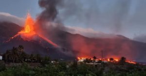
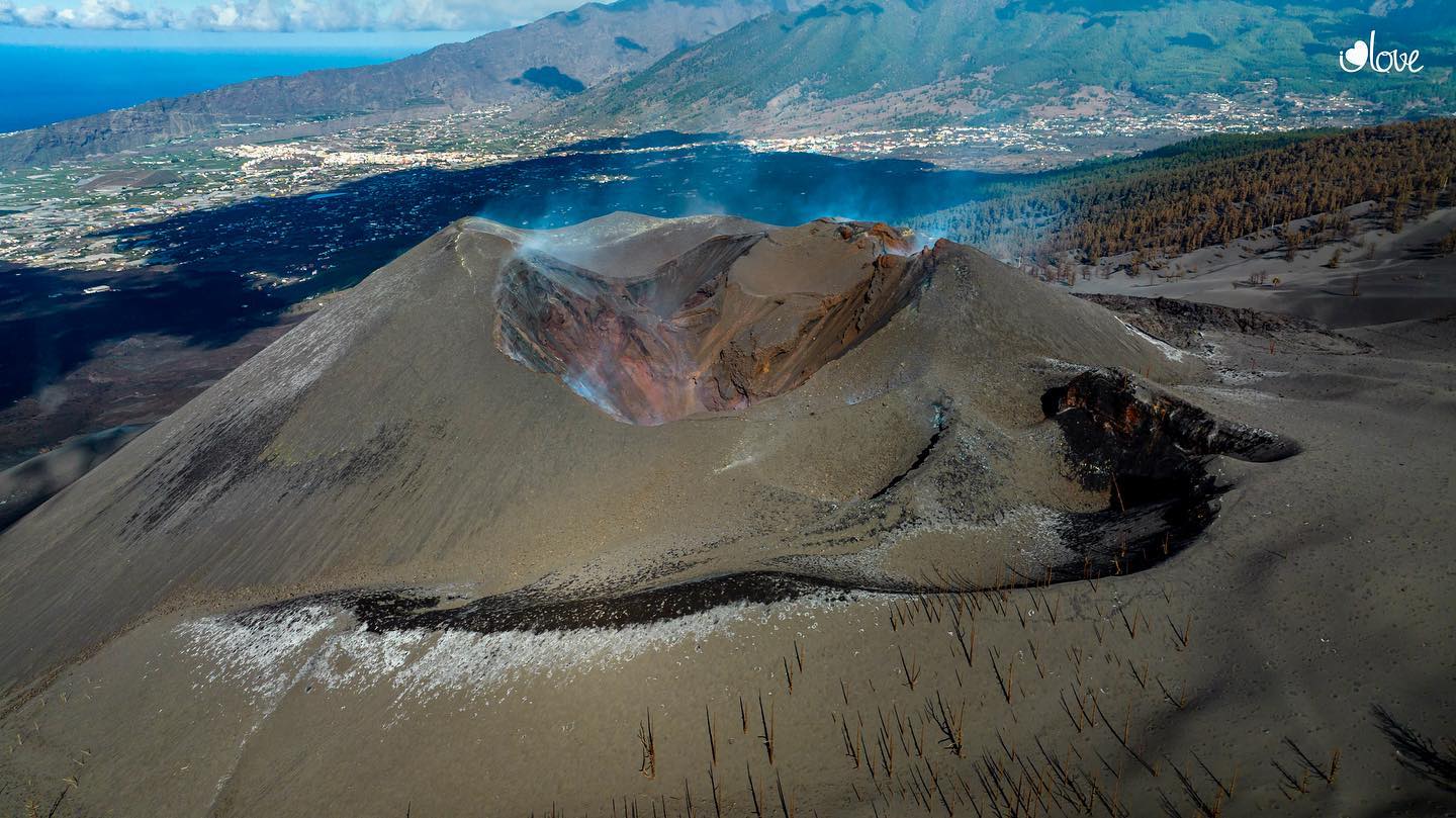
Spain / La Palma , Cumbre Vieja :
December 24, 2021 09:00 UTC. Volcanic monitoring continues on La Palma.
Since the last declaration, 13 earthquakes have been located on the island of La Palma, none of them have been felt by the population.
The magnitudes are between 1.4 and 2.5 (mbLg). The localization of hypocenters continues under the central area of Cumbre Vieja in the same areas as the previous days. 11 earthquakes were located at depths between 8 and 21 km and 2 at depths of about 35 km. No earthquake was located at a depth of less than 8 km.
There is still no volcanic tremor observed, the seismic noise remains at levels close to the pre-eruptive period.
The island’s network of permanent GNSS stations shows a complete reversal of the elevation recorded on December 19 at station LP03, which is closest to the eruptive centers. In the rest of the stations, there are no significant deformations that could be associated with volcanic activity.
As in the previous days, no type of emission is appreciated and the height of the cone is measured, obtaining a value of 1,122 m on sea level.
Sulfur dioxide (SO2) emission into the atmosphere from the current eruptive process at Cumbre Vieja was low yesterday. The low to very low emission rates are not related to the ascent of the magma, but to a process of solidification of the surface magma existing in the conduits of the eruptive center. In the case of non-visible volcanic gas emanations, the diffuse emission of carbon dioxide (CO2), associated with the 220 km2 of the volcanic system of Cumbre Vieja, continues to reflect an emission above the average value of background levels and yesterday , this diffuse emission was 7.3 times higher than the average for background levels.
Source : IGNes
Photo : I love the world.
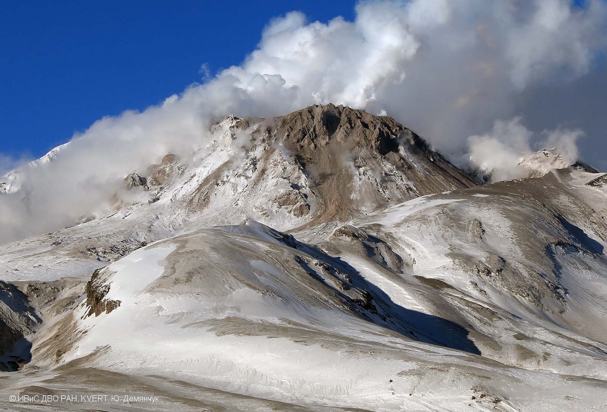
Kamchatka , Sheveluch :
VOLCANO OBSERVATORY NOTICE FOR AVIATION (VONA)
Issued: December 24 , 2021
Volcano: Sheveluch (CAVW #300270)
Current aviation colour code: ORANGE
Previous aviation colour code: orange
Source: KVERT
Notice Number: 2021-156
Volcano Location: N 56 deg 38 min E 161 deg 18 min
Area: Kamchatka, Russia
Summit Elevation: 3283 m (10768.24 ft), the dome elevation ~2500 m (8200 ft)
Volcanic Activity Summary:
A growth of the lava dome continues, a strong fumarolic activity, and an incandescence of the lava dome and hot avalanches accompanies this process. Video and satellite data by KVERT showed a strong fumarolic activity of the volcano. Sometimes gas-steam plumes containe some amount of ash, these plumes move to the northeast of the volcano.
The extrusive eruption of the volcano continues. Ash explosions up to 10-15 km (32,800-49,200 ft) a.s.l. could occur at any time. Ongoing activity could affect international and low-flying aircraft.
Volcanic cloud height:
3500 m (11480 ft) AMSL Time and method of ash plume/cloud height determination: 20211224/0219Z – Video data
Other volcanic cloud information:
Distance of ash plume/cloud of the volcano: 80 km (50 mi)
Direction of drift of ash plume/cloud of the volcano: NE / azimuth 48 deg
Time and method of ash plume/cloud determination: 20211224/0150Z – Himawari-8
Start time of explosion and how determined: 20211224/0030Z – Satellite data
Source : Kvert.
Photo : Yu. Demyanchuk, IVS FEB RAS, KVERT ( Archive 2020).