December 19 , 2021.
Spain , Tenerife :
SISMO-VOLCANIC ACTIVITY IN TWO ZONES OF THE CENTER OF TENERIFE, IN THE CALDERA AND ON ITS WEST SIDE IN THE REGION OF ADEJE AND GUIA DE ISORA.
These days, it was almost a monograph of La Palma. But Tenerife for several days shows seismic activity at around 6-8 km in the Adeje area and around 8-11 km in the Caldera and Guia de Isora area. The IGN, located around 11 in the region in 15 days. But when we remove this swarm, it turns out that in 14 days there were 59 located by Involcan in the same areas.
This is not new, it is an activity that started 5 years ago There had already been stronger swarms in this area, in October 2016, November 2017, November 2018, July 2019, December 2020 and more … we arrive at 2004. Seismicity has been located in the area since the 1980s.
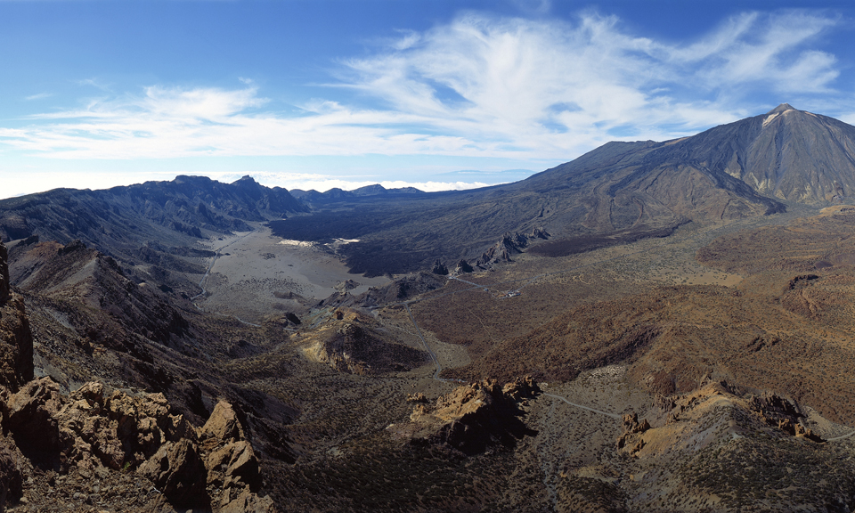
The large triangular island of Tenerife is composed of a complex of overlapping Miocene-to-Quaternary stratovolcanoes that have remained active into historical time. The NE-trending Cordillera Dorsal volcanic massif joins the Las Cañadas volcano on the SW side of Tenerife with older volcanoes, creating the largest volcanic complex of the Canary Islands. Controversy surrounds the formation of the dramatic 10 x 17 km Las Cañadas caldera, which is partially filled by Teide stratovolcano, the highest peak in the Atlantic Ocean. The origin of the caldera has been variably considered to be due to collapse following multiple major explosive eruptions or as a result of a massive landslide (in a manner similar to the earlier formation of the massive La Orotava and Guimar valleys), or a combination of the two processes. The most recent stage of activity beginning in the late Pleistocene included the construction of the Pico Viejo and Teide edifices. Tenerife was perhaps observed in eruption by Christopher Columbus, and several flank vents on the Canary Island’s most active volcano have been active during historical time.
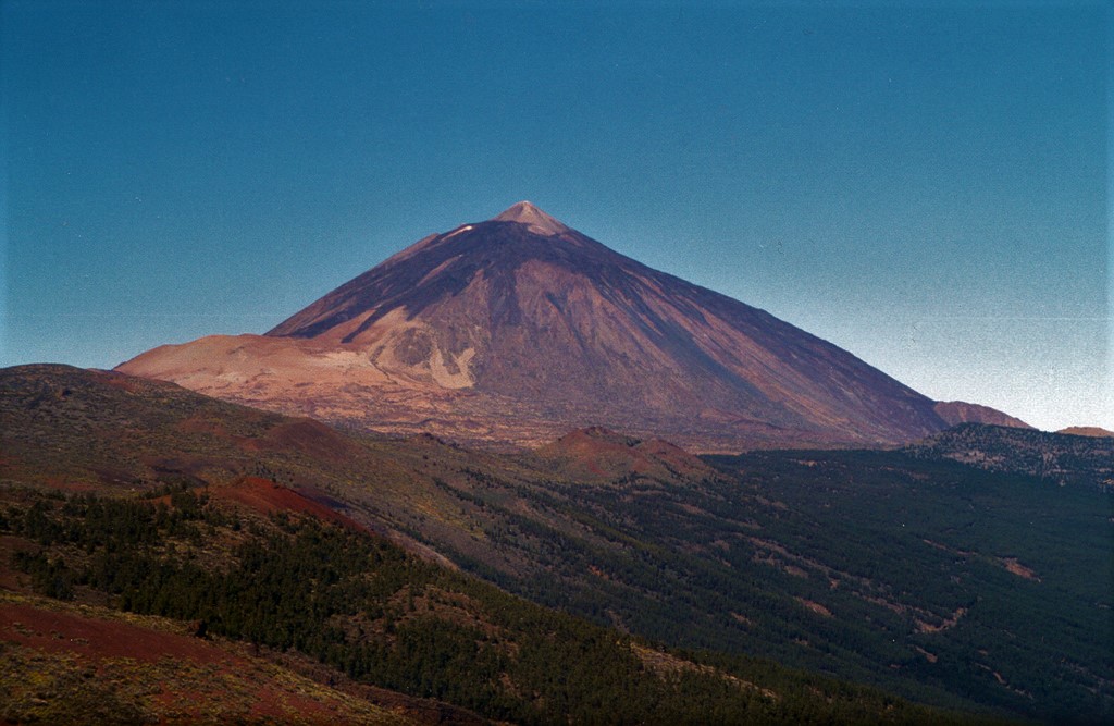
Teide volcano, the highest point on the island of Tenerife, towers above the scarp of the massive Orotava landslide, which occurred about 600,000 years ago. The light-colored area on the eastern foot of the volcano (left) is covered by tephra deposits from the Plinian Montana Blanca eruption about 2,000 years ago. Teide was constructed within the 10 x 16 km wide Las Cañadas caldera on the SW side of Tenerife. The large triangular island is composed of a complex of overlapping stratovolcanoes that have remained active into historical time.
It turns out that the central volcano of Tenerife is very large, the third largest on the planet by volume. While the Teide-Pico Viejo volcanic complex also erupts, these are not always basaltic eruptions. , the majority in this area are phonolitic, much more explosive and of course more powerful than that experienced in La Palma.
And let’s not forget, it is active too and where the phonolitic reservoir is located under the caldera, could indicate deep contributions.
Sources : GVP , Volcanes y Ciencia Hoy .
Photo : volcanoteide.com , Alexander Belousov, 2001 (Institute of Volcanology, Kamchatka, Russia).
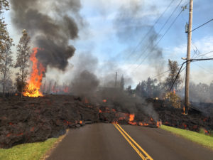
Spain / La Palma , Cumbre Vieja :
December 18, 2021 09:00 UTC Volcanic monitoring continues in La Palma.
Since the last declaration a total of 40 earthquakes have been located on the island of La Palma, none of these earthquakes have been felt by the population.
The maximum recorded magnitude is 2.8 (mbLg), corresponding to yesterday’s earthquakes at 11:31 and 14:54 UTC, at a depth of 33 and 14 km, respectively. The minimum magnitude of localized seismicity was 0.9 mbLg.
Localized seismicity continues below the central area of Cumbre Vieja in the same areas as the previous days. The earthquakes mainly fall into two groups, 22 of the earthquakes are between 7 and 16 km deep and 15 earthquakes at depths greater than 30 km. Likewise, 3 shallow earthquakes were located in the area, with a depth of less than 4 km.
During the past 24 hours, no volcanic tremor has been observed in the records, keeping the seismic noise at levels close to the pre-eruptive period.
Since the cessation of the volcanic tremor signal on December 13 at 10:20 p.m., events of the low frequency (LP) type have continued to be detected in addition to localized volcano-tectonic earthquakes.
The island’s network of permanent GNSS stations does not show significant deformations that could be associated with volcanic activity.
In view of the image calibrated at 08:45 UTC, no type of emission is visible.
The height of the cone is measured by obtaining a value of 1122 m at sea level.
The eruptive process continues to show signs of exhaustion and the visible emission of volcanic gases is punctual and sporadic and is concentrated in the eruptive centers and offshoots of the volcanic tubes.

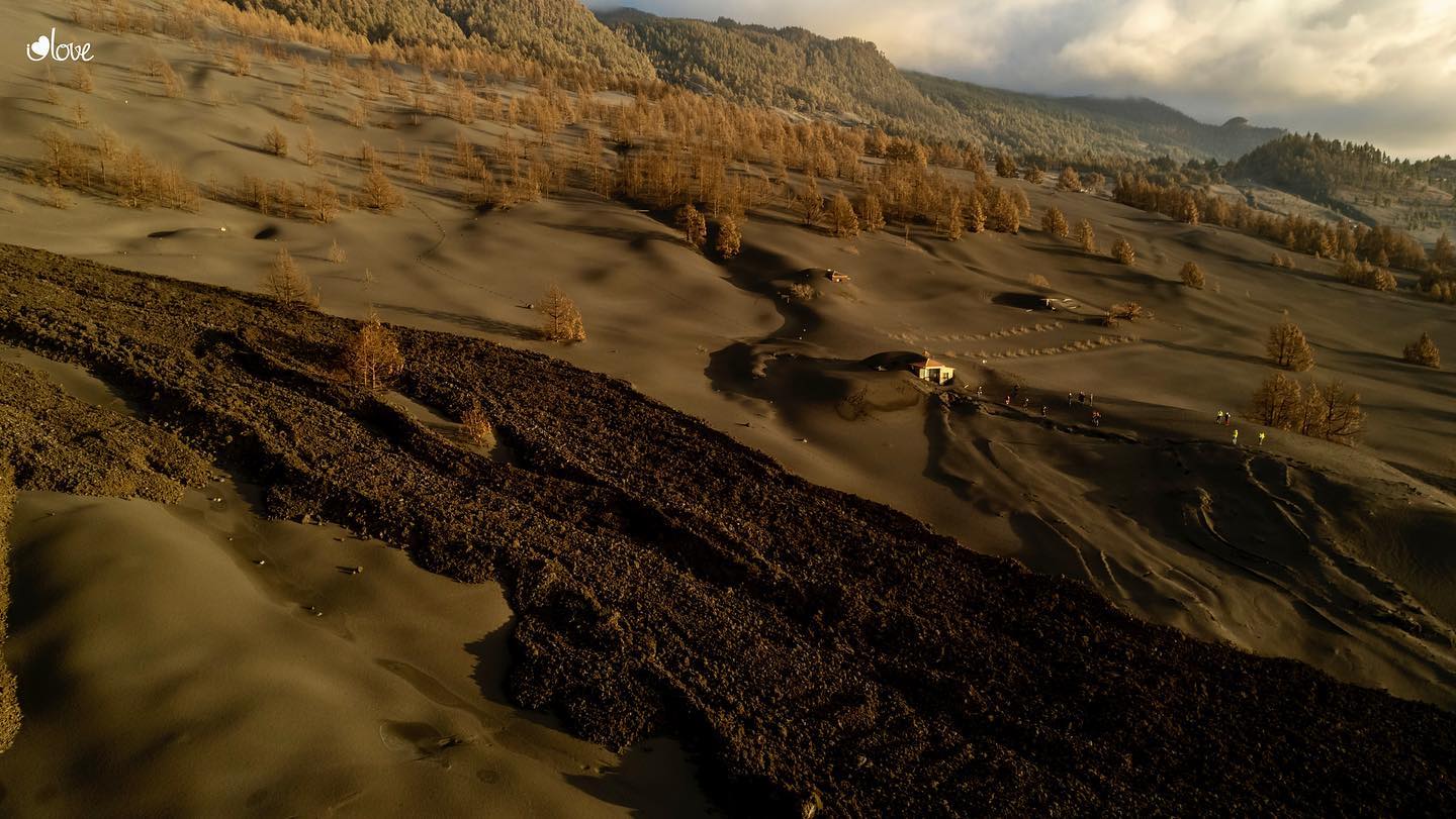
The scientific committee monitoring the eruption in Cumbre Vieja, La Palma, on Friday detected « a small flow » of lava on the surface on the flows that fall in the area of the cliff of Las Hoyas, although the « signs of depletion ”of the volcano persist. Its spokesperson, María José Blanco, indicated this Saturday after the meeting of the Volcanic Emergency Plan of the Canary Islands (Pevolca) that this « small lava flow » corresponds to « a vestige » which comes from a still volcanic tube active.
However, he stressed that in the absence of observable phenomena on the surface and those of the surveillance system « the signs of exhaustion are corroborated », without ruling out a rebound in Strombolian activity and the emission of flows.
Sources : IGN es , El Pais .
Photo : I love the world . Involcan .
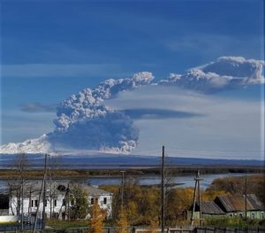
Indonesia , Semeru :
VOLCANO OBSERVATORY NOTICE FOR AVIATION – VONA.
Issued : Décember 18 , 2021
Volcano : Semeru (263300)
Current Aviation Colour Code : ORANGE
Previous Aviation Colour Code : orange
Source : Semeru Volcano Observatory
Notice Number : 2021SMR85
Volcano Location : S 08 deg 06 min 29 sec E 112 deg 55 min 12 sec
Area : East java, Indonesia
Summit Elevation : 11763 FT (3676 M)
Volcanic Activity Summary :
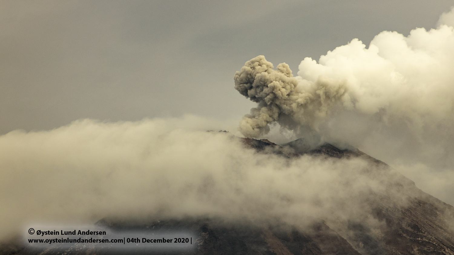
Pyroclastic flow occured from the edge of lava deposit at 22h31 UTC ( 05h31 local )
Volcanic Cloud Height :
Ash-cloud is not visible
Other Volcanic Cloud Information :
Ash-cloud moving to South West
Remarks :
Lava flow is observed through the Southeast direction of the Semeru summit crater.
Clear to misty volcano. No smoke from the crater was observed.
It was observed 2 hot cloud avalanches with a sliding distance of 500 meters in the direction of Besuk Kobokan, as well as an emission of gray / white smoke with a height of 200 meters above the summit in a southwest direction. .
Seismicity is linked to the activity of magma as well as to tectonic activity.
– 2 hot cloud avalanches
– 5 avalanche earthquakes
– 12 earthquakes of emissions
– 3 deep volcanic earthquakes
– 8 distant tectonic earthquakes
Sources : Magma Indonésie , PVMBG.
Photo : Oystein Lund Andersen.
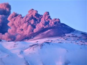
Chile , Villarica :
Special Report on Volcanic Activity (REAV), La Araucanía region, Villarrica volcano, December 17, 2020, 5:50 p.m. local time (Continental Chile)
The National Service of Geology and Mining of Chile (Sernageomin), on the basis of information obtained through the monitoring equipment of the National Volcanic Monitoring Network (RNVV), processed and analyzed in the Volcanic Observatory of the Southern Andes (Ovdas), and in relation to the activity of the Villarrica volcano, reports the following:
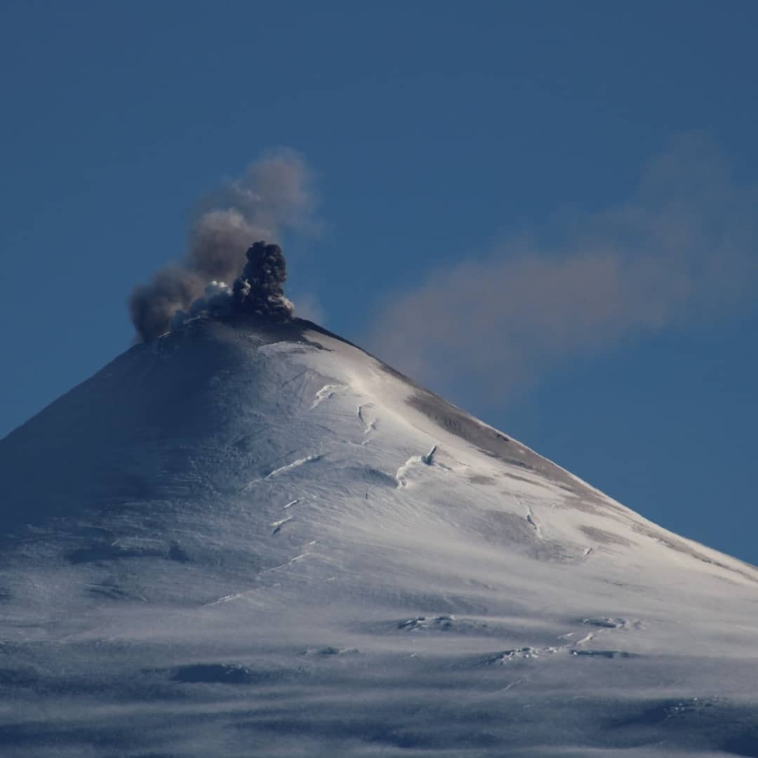
On Thursday, December 17, at 5:16 p.m. local time (8:16 p.m. UTC), IP cameras installed near the volcano recorded a pulse of particulate matter, associated with a long-period (LP) type earthquake.
The data obtained are as follows:
MAXIMUM HEIGHT OF THE COLUMN: 720 m with particle emission.
DISPERSAL DIRECTION: East-South-East (ESE)
REDUCED DISPLACEMENT: 7.7 cm2
Remarks :
At the time of publication of this report, the monitoring parameters do not show significant variations.
The volcanic alert remains at the level: Yellow.
Source : Sernageomin.
Photo : Volcanologia en Chile ( archive).
Costa Rica , Turrialba / Poas :
Turrialba volcano:
No eruption is reported.
Seismic activity is higher than yesterday.
At the time of this report, the winds are blowing from the southwest.
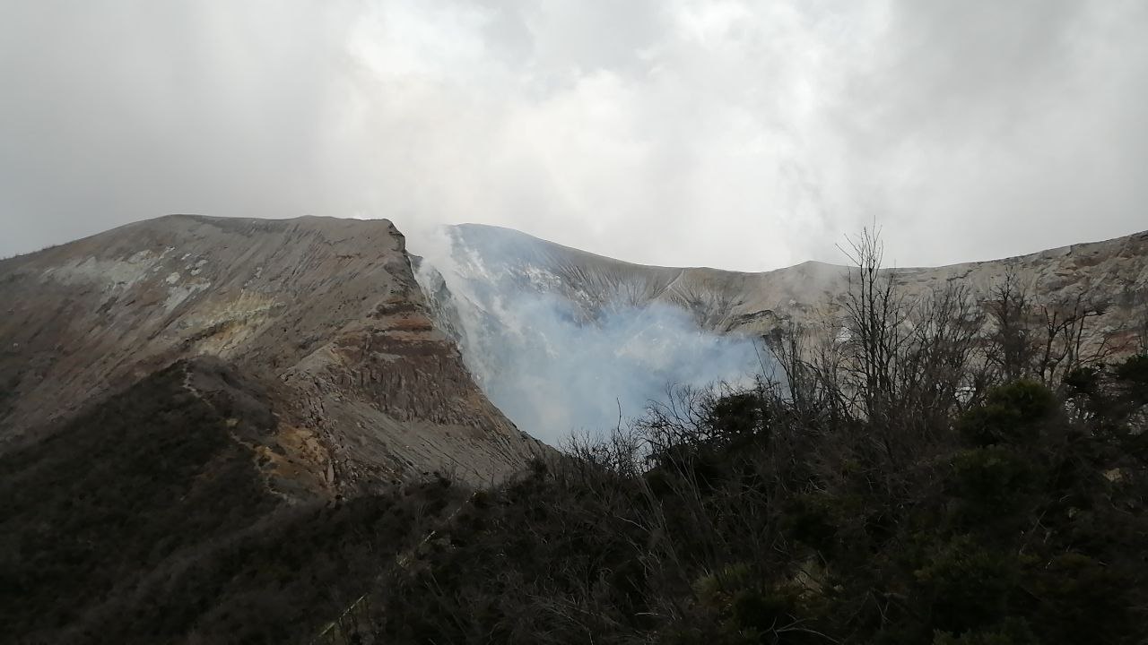
Significant degassing is observed in the main crater. The CO2 / SO2, H2S / SO2 gas ratios and the SO2 concentration are relatively stable: 19.9; 0.85 and 6.47 ppm, respectively. The volcanic deformation of the building is not significant.
Poas volcano:
No eruption is reported.
Seismic activity is similar, compared to yesterday.
At the time of this report, the winds are blowing from the southwest.
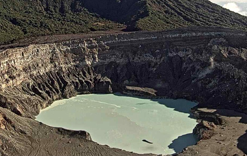
Due to the high cloud cover, it is not possible to make observations in the main crater. Both the H2S / SO2 ratio and the SO2 concentration remain relatively stable: 0.75 and 1.59 ppm; respectively. The SO2 concentration at the watchtower this morning was less than 1 ppm. There is no significant deformation of the volcanic building.
Source : Ovsicori.
Photos : Jean Paul Calvo /RSN , Ovsicori.
La Martinique , Montagne Pelée :
Weekly report on the activity of Mount Pelée for the period from December 10 to 17, 2021.
Between December 10, 2021 at 4 p.m. (UTC) and December 17, 2021 at 4 p.m. (UTC), the OVSM recorded at least 27 volcano-tectonic earthquakes of magnitude less than or equal to 0.9 and located at l inside the volcanic edifice between 2.5 and 0.5 km deep below the surface. This volcano-tectonic-type superficial seismicity is associated with the formation of micro-fractures in the volcanic edifice. None of these earthquakes were felt by the population.
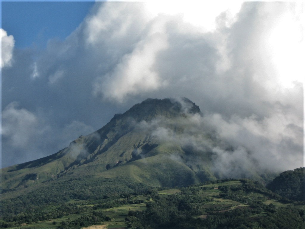
The shallow sea degassing zone between St Pierre and le Prêcheur is still observed. The IGP took fluid samples in order to understand the origin of this degassing and to assess its possible relationship with the hydrothermal system of Mount Pelée.
The vegetation grows back at the level of the main zone of degraded vegetation which is observed on the southwest flank of Mount Pelée, between the upper Claire river and the Chaude river. However, new areas of deteriorated and dead vegetation were detected by analysis of satellite images in the upper Claire River and near the hot springs.
The alert level remains YELLOW: vigilance.
Source : Direction de l’OVSM IPGP.
Photo : Jmp48 / Wikipedia