December 11 , 2021.
Alaska / Aleutians , Davidof :
Alaska Volcano Observatory Activity Notice . Ven 10/12/2021 22:57
Current Volcano Alert Level: ADVISORY
Current Aviation Color Code: YELLOW
Issued: Friday, December 10, 2021, 12:38 PM AKST
Source: Alaska Volcano Observatory
Notice Number: 2021/A1108
Location: N 51 deg 57 min E 178 deg 19 min
Elevation: 1076 ft (328 m)
Area: Aleutians
Volcanic Activity Summary:
Over the past three days a swarm of earthquakes has occurred in the vicinity of Davidof volcano. The largest earthquake to date happened this morning at about 19:45 UTC (10:45 am AKST) and had a magnitude of 4.2. This swarm may be associated with volcanic unrest or it could also be due to regional tectonic activity. Due to the possibility of escalating volcanic unrest, AVO is raising the Aviation Color Code and Volcano Alert Level for Davidof to YELLOW/ADVISORY. AVO is continuing to monitor the situation with seismometers deployed on nearby islands since there is no real-time seismic monitoring network at Davidof volcano. The closest seismometers to Davidof are approximately 15 km to the east of the volcano on Little Sitkin Island.
Recent Observations:
[Volcanic cloud height] no cloud present
[Other volcanic cloud information] no cloud present
Remarks:
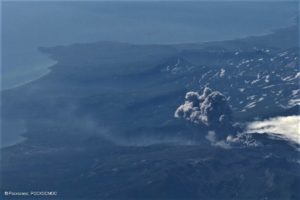
Davidof volcano is a mostly submerged stratovolcano in the Rat Islands group in the western Aleutian Islands, about 350 km west of Adak. The subaerial part of the volcano comprises Davidof, Khvostof, Pyramid, and Lopy islands, which encircle Crater Bay, a 2.5 km diameter caldera. The islands are built up from interbedded lava flows and explosive deposits. The volcano has been sparsely studied, but visits by Alaska Volcano Observatory geologists in 2021 documented thick sequences of rhyolite to dacite pyroclastic flow and fall deposits that represent the most recent explosive eruptions. The age of these deposits is unknown, but they appear older than Holocene deposits from nearby Segula and Little Sitkin. There are no known historical eruptions from Davidof.
Source : AVO.
Photo : Neal, C. A.; Larsen, J. F. Alaska Volcano Observatory / U.S. Geological Survey / University of Alaska Fairbanks Geophysical Institute
Indonesia , Merapi :
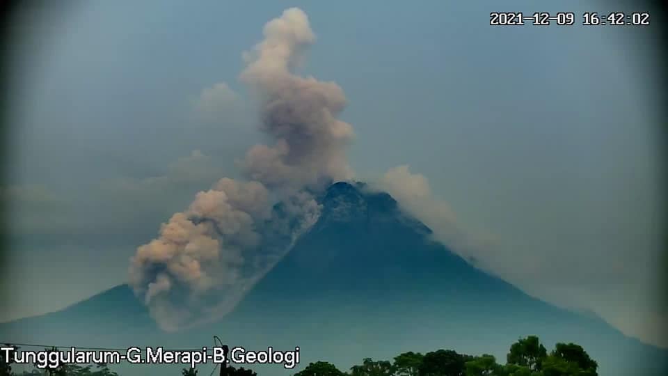
Mont Merapi activity report, from December 3 to 9, 2021.
– The weather around Mount Merapi is generally sunny in the morning and evening, while the afternoon is foggy.
– This week, 4 hot cloud avalanches were observed descending in the Bebeng River with a maximum slide distance of 2200 m. Lava avalanches have been observed up to 190 times southwestward down to Sungai Bebeng with a maximum slide distance of 2,000 m.

– The southwest lava dome as well as the central dome, observed, continue to grow. The volume of the southwest lava dome is 1.629,000 m3 and the central dome is 3.007,000 m3.
– The intensity of the seismicity this week is still relatively high. The deformation of Mount Merapi, which was monitored using EDM this week, showed a distance shortening rate of 0.5 cm / day.
– The maximum rainfall intensity was 53 mm / hour for 80 minutes at Pos Babadan on December 9, 2021. An increase in flow and lahars was reported in the Gendol, Boyong and Pabelan rivers.
Conclusion:
– The volcanic activity of G. Merapi is still quite high as an effusive eruption activity. The activity status is determined at the « SIAGA » level.
– The potential dangers are lava avalanches and hot cloud avalanches in the South-East / South-West sector up to a maximum of 3 km towards the Woro river, and up to 5 km towards the Gendol, Kuning rivers , Boyong, Bedog, Krasak, Bebeng and Putih. The ejection of volcanic material during an explosive eruption can reach a radius of 3 km from the summit.
Volcanic earthquakes linked to hot cloud avalanches, lava avalanches, crater smoke emissions, lava domed growth and tectonic activity
– 1 hot cloud avalanches
– 125 avalanche earthquakes
– 4 earthquakes of emissions
– 1 multi-phase earthquake
– 3 distant tectonic earthquakes
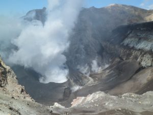
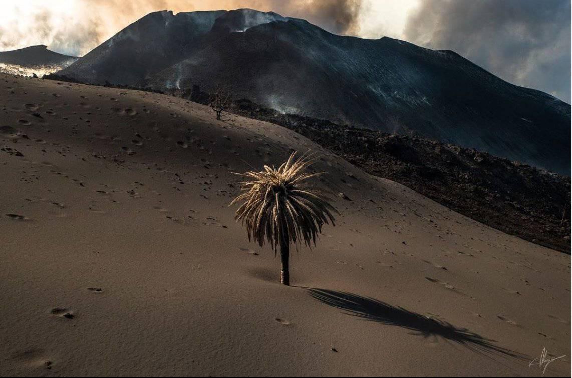
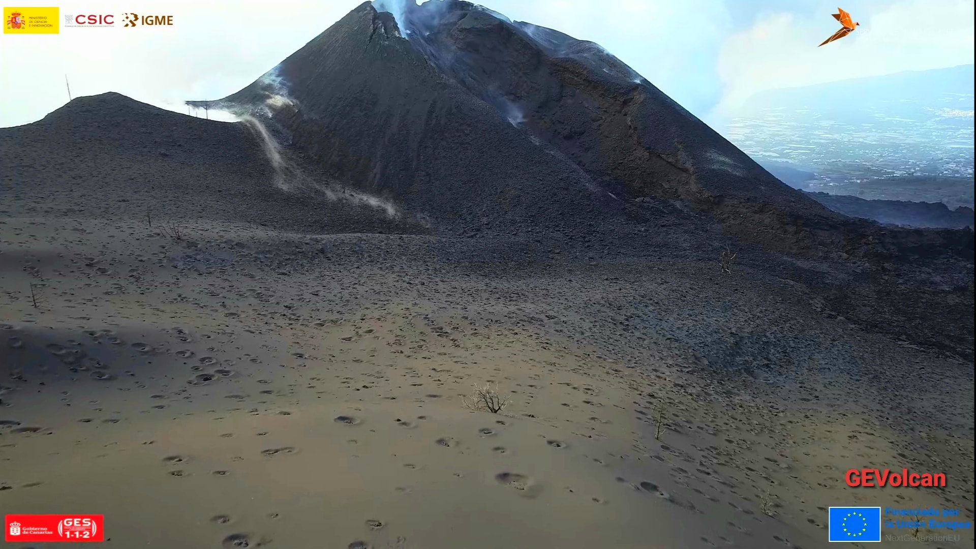
Spain / La Palma , Cumbre Vieja :
December 10, 2021, 09:00 UTC. Eruptive activity continues on La Palma.
Since the last declaration, a total of 15 earthquakes have been located on the island of La Palma, none of them have been felt by the population.
The maximum recorded magnitude is 3.4 (mbLg), corresponding to today’s earthquake at 07:04 UTC, at a depth of 39 km.
The seismicity continues under the central area of Cumbre Vieja in the same areas of the previous days, most of the earthquakes (13) are located at depths between 9 and 15 km, the rest (3) were located at depths included between 29 and 39 km. No earthquake was located at depths less than 9 km.
The amplitude of the tremor signal remains at low levels, with a slight increase in the last hours.
As in previous days, the island’s network of permanent GNSS stations does not show a clear trend in the deformation of the stations closest to the eruptive centers.
In the rest of the stations, the slight deflation possibly linked to the deep seismicity has stabilized, except in LP01 which continues to record it.
In view of the image calibrated at 08:45 UTC, an ash cloud height of 1,200 m is estimated, with a direction of dispersion towards the South-South-West.
The height of the cone is measured by obtaining a value of 1,123 m at sea level.
Diffuse CO2 flux measurements were carried out on the eastern slope of the main building in order to determine the most appropriate point from which to take a fumarolic gas sample.
.
Sources : IGN es , El Pais .
Photos : Javi Rodriguez , GEVolcan .
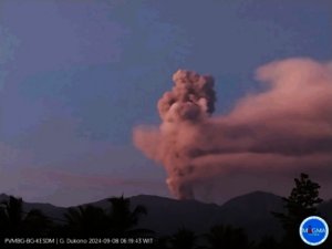
Ecuador , Sangay :
DAILY REPORT ON THE STATE OF SANGAY VOLCANO. December 10, 2021.
Surface activity level: High, Surface trend: Ascending.
Internal activity level: High, Internal trend: Ascending.
Seismicity: From December 09, 2021, 11:00 a.m. to December 10, 2021, 11:00 a.m .:
Long Periods (LP) type events 33
Explosions (EXP) 10
Emission Tremors (TREMI) 7
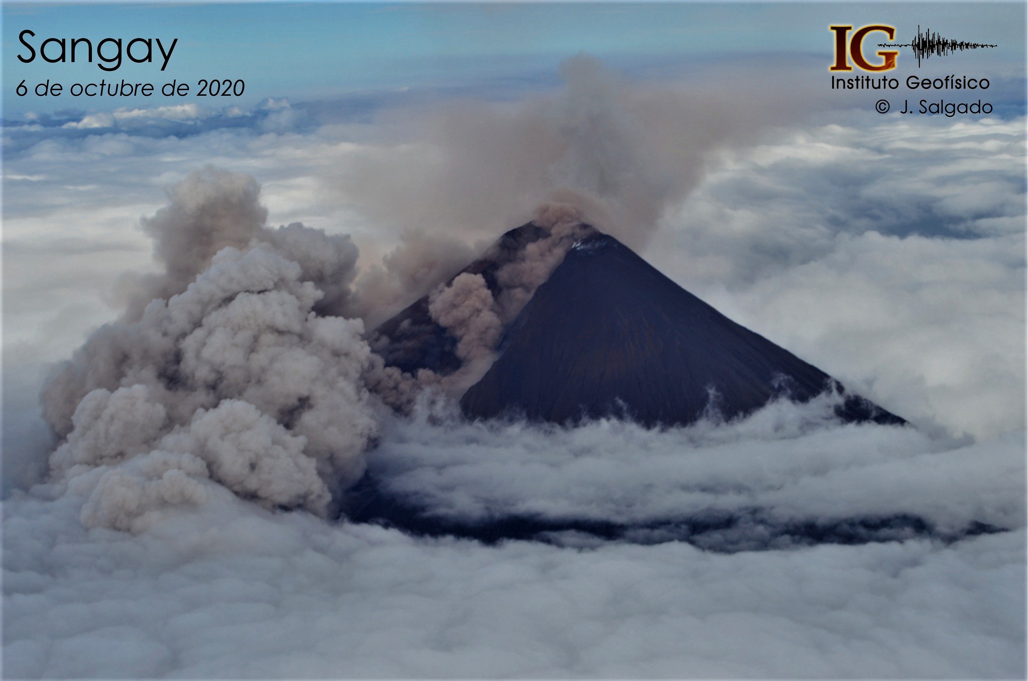
The Sangay volcano is today one of two erupting volcanoes in Ecuador, along with El Reventador. This photograph of October 6, 2020 shows us the generation of pyroclastic currents which descend through the gully formed on the south-eastern flank and whose ashes are dispersed.
Rains / Lahars:
Rains were recorded in the area of the volcano.
Emission column / ash:
Yesterday afternoon a transmission of 1000 meters was observed with a southwest direction, moreover the VAAC of Washington reported 4 emissions, the first of 570 meters with a southwest direction, the second of 870 meters with a direction Northwest and following were 1170 meters in a southwest and west direction.
Other monitoring parameters:
FIRMS records 38 thermal alerts and MIROVA records 1 high thermal alert (463 MW) on the Sangay during the last 24 hours
Observation:
In the morning hours, the area was clear. Right now the area is completely cloudy.
Alert level: yellow.
Source et photo : IGEPN.
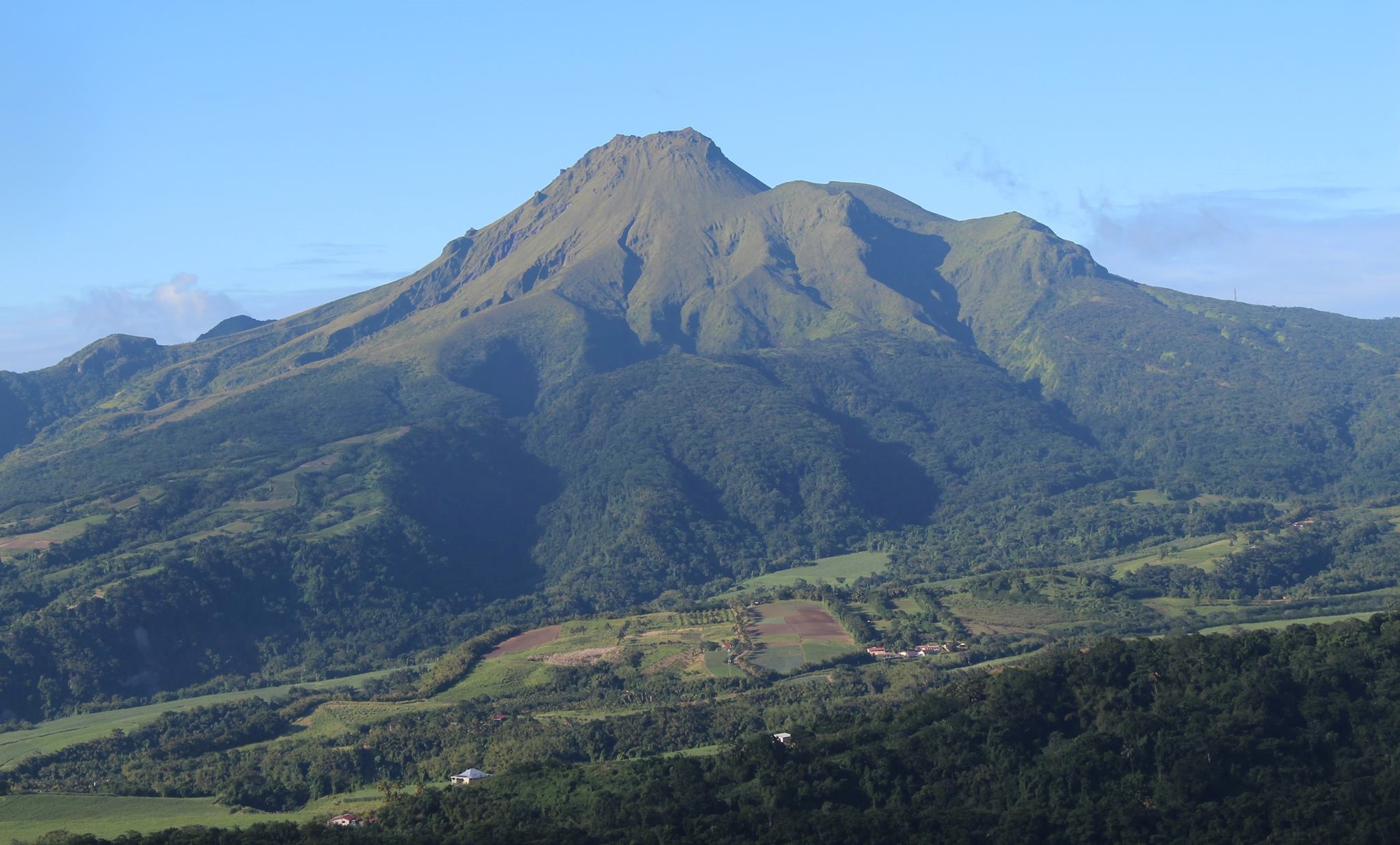
La Martinique , Montagne Pelée :
Weekly report on the activity of Mount Pelée for the period from December 3 to 10, 2021.
Between December 3, 2021 at 4 p.m. (UTC) and December 10, 2021 at 4 p.m. (UTC), the OVSM recorded at least 7 volcano-tectonic earthquakes including:
5 earthquakes of magnitude less than or equal to 0.1 and located inside the volcanic structure between 0.7 and 1.2 km below sea level. This volcano-tectonic type surface seismicity is associated with the formation of micro-fractures in the volcanic edifice.
2 earthquakes of magnitude less than or equal to 1.2 located west-southwest of Grand Rivière, at 6.2 and 8.4 km depth below the surface. The observation of earthquakes of intermediate depth is a new change observed in the level of the activity of the volcano, which could be associated with a change in pressure and fracturing in and near the volcanic edifice. None of these earthquakes were felt by the population.
The shallow sea degassing zone between St Pierre and le Prêcheur is still observed. The IGP took fluid samples in order to understand the origin of this degassing and to assess its possible relationship with the hydrothermal system of Mount Pelée.
The vegetation grows back at the level of the main zone of degraded vegetation which is observed on the southwest flank of Mount Pelée, between the upper Claire river and the Chaude river. However, new areas of deteriorated and dead vegetation were detected by analysis of satellite images in the upper Claire River and near the hot springs.
The alert level remains YELLOW: vigilance.
Source : Direction de l’OVSM IPGP.
Photo : OVSM IPGP