November 10 , 2021.
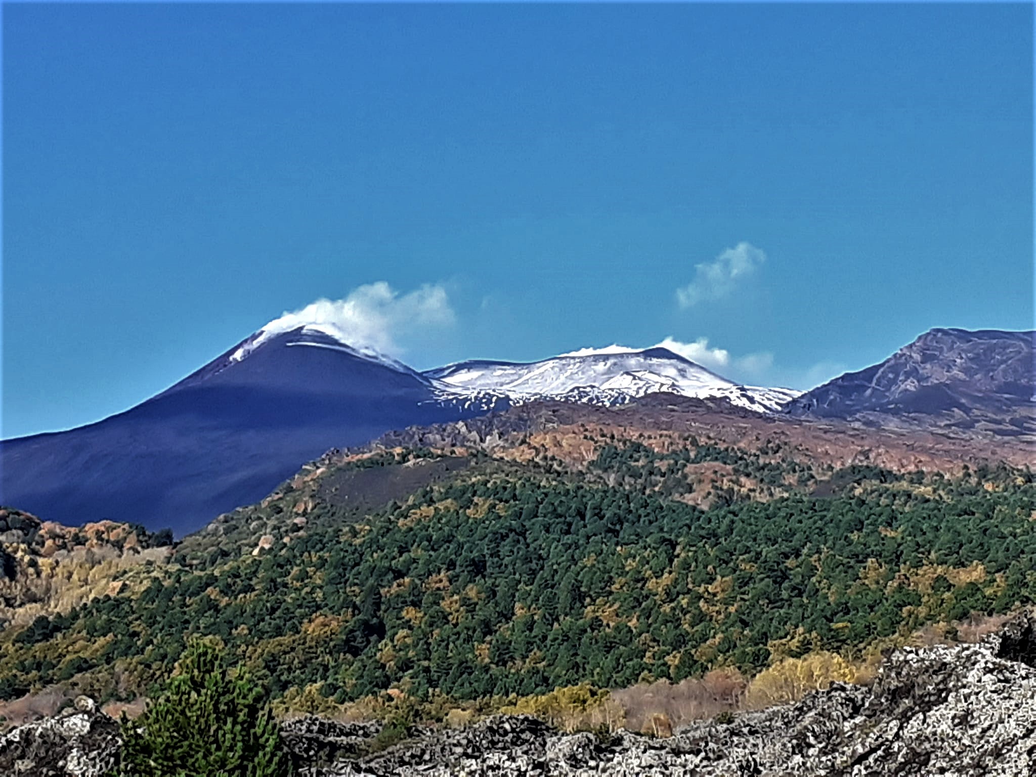
Italy / Sicily , Etna :
Weekly Bulletin from November 01, 2021 to November 07, 2021 (Issue date November 09, 2021)
SUMMARY STATEMENT OF ACTIVITY
In view of the monitoring data, it is highlighted:
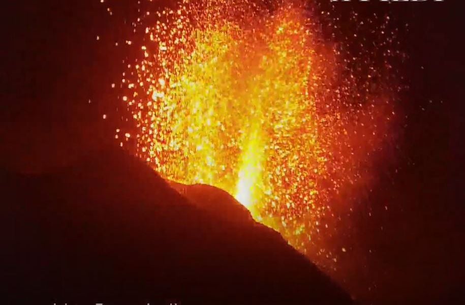
1) VOLCANOLOGICAL OBSERVATIONS: Degassing activity of summit craters; sporadic and modest ash emissions from the Southeast Crater.
2) SEISMOLOGY: Weak seismic activity of fracturing; average amplitude of the volcanic tremor in the average level.
3) INFRASONO: Low infrasound activity
4) DEFORMATIONS: During the last week, the GNSS and inclinometric networks did not show any significant changes.
5) GEOCHEMISTRY: The flow of SO2 is placed at an average level.
The flux of CO2 emitted by soils is characterized last week by values that fluctuate from high to very high, with a peak at 09 m.c.
The partial pressure of CO2 dissolved in water shows no significant change.
The helium isotope ratio appears on average to high values (latest data from 10/20/2021) with a slight decrease.
There are no updates for the C / S report.
6) SATELLITE OBSERVATIONS: The thermal activity in the summit area was at a low level.
VOLCANOLOGICAL OBSERVATIONS.
During the week, the monitoring of the volcanic activity of Etna was carried out by analyzing the images of the surveillance cameras of the INGV, Osservatorio Etneo (INGV-OE).
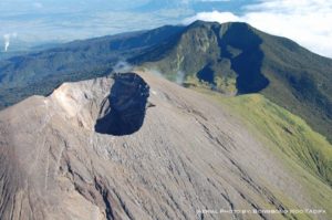
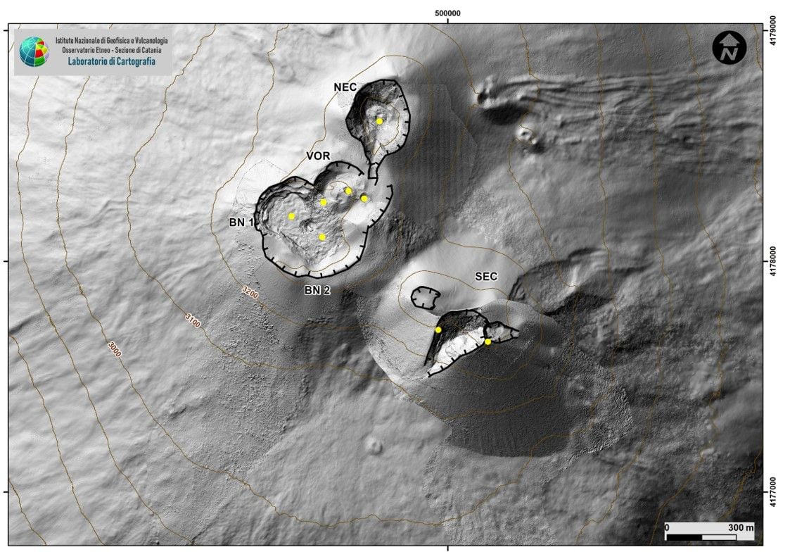
Overall, the state of activity of the summit craters showed no change from what had been observed the previous week. In particular, the degassing activity of the summit craters was mainly carried out by the collapse craters located in the North-West sector of the Bocca Nuova (BN-1 in Fig. 3.1), and by the North-East Crater (Fig.3.2). The Voragine craters and the Southeast Crater, on the other hand, showed extensive degassing linked to the fumarole systems present along the edges of the crater.
Volcanic tremor:
The mean amplitude of the volcanic tremor remained mostly in the mid-range range, with a slight tendency to increase during the last two days of the week. The locations of the centroids of the volcanic tremor sources implied a small volume in correspondence with the crater of Bocca Nuova, at an altitude of about 3000 meters above mean sea level.
Source : INGV.
Photos : INGV , Catherine Lemercier
Spain / La Palma , Cumbre Vieja :
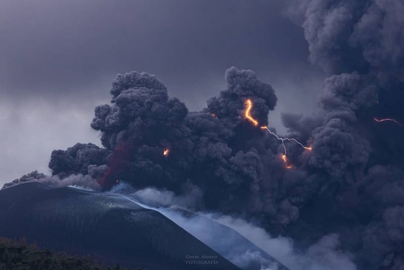
November 09, 2021, 09:00 UTC. Eruptive activity continues on La Palma.
Since the last declaration, 80 earthquakes have been located in the area affected by the volcanic reactivation of Cumbre Vieja, 7 of these earthquakes were felt by the population, having reached in the epicentral zone the maximum intensity of III- IV (EMS98).
The largest earthquake is the one that occurred at 6:55 a.m. (UTC) today, with a magnitude of 3.8 mbLg at a depth of 38 km and felt with intensity II on the island of La Palma.
In the period considered, 4 earthquakes were located at a depth of about 30 km, the rest of the hypocenters of the period are located at a shallower depth, around 12 km.
The amplitude of the volcanic tremor signal continues at lower average levels with intensification peaks.
The island’s network of permanent GNSS stations shows that after reversing the inflation on days 4 and 5 at station LP03, which is closest to the eruptive centers, it remains at a lower level than previously established. On the other hand, the southwest deformation recorded in the station is still continuing.
In the rest of the stations, a slight deflation is maintained, perhaps linked to deep seismicity.
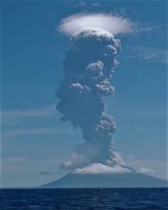
In view of the calibrated image, an ash cloud altitude of 2,700 m is estimated at 08:45 UTC with a southwest direction. The altitude of the cone is measured by obtaining a value of 1,131 m. on sea level.
Lava from the Cumbre Vieja volcano, in La Palma, arrived on Tuesday at Los Guirres beach, next to the lava delta previously created by the main flow, after several days of no progress. A « small overflow » of magma had previously been reported between the two fronts approaching the coast south of La Laguna Mountain.
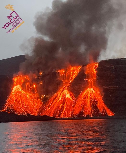
Sulfur dioxide emissions reach values between 9,000 and 13,000 tonnes per day. These levels remain high, but the evolution over time reflects a downward trend.
The La Palma volcano returns in a “more stable” phase. This is how the director in the Canaries of the National Geographical Institute (IGN), María José Blanco, admitted this Tuesday. This stability should be maintained « for a certain time » and even decrease « gradually and maintained » in all parameters: seismicity, deformation, tremor and gas emission, detailed the spokesperson for the scientific committee following the eruption.
Sources : IGN es , El Pais .
Photos : Omar Alonso , Involcan
Italy , Stromboli :
Weekly Bulletin from November 01, 2021 to November 07, 2021 (Issue date November 09, 2021)
SUMMARY STATEMENT OF ACTIVITY
In view of the monitoring data, it is highlighted:
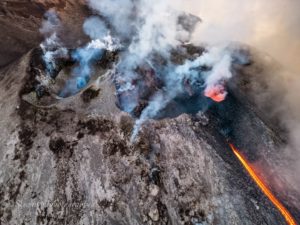
1) VOLCANOLOGICAL OBSERVATIONS: During this period a normal explosive activity of strombolian type with a splashing activity was observed. The total hourly frequency of explosions fluctuated between medium-high and high values (19-25 events / h). The intensity of the explosions varied from low to medium in the North crater area and low in the Center-South area.
2) SEISMOLOGY: The seismological parameters monitored do not show significant variations.
3) DEFORMATIONS: The island’s soil deformation monitoring networks did not show any significant changes to report for the period under review
4) GEOCHEMISTRY: the flow of SO2 at a medium-high level
There is no update of the values of the CO2 flux emitted by the ground on the Pizzo compared to the previous bulletin, in which the values were at medium-high levels.
There are no updated values of the C / S ratio from the previous bulletin, in which the values were at average levels.
There is no update of the isotopic ratio of Helium dissolved in the Stromboli thermal aquifer, where the values were at high levels.
5) SATELLITE OBSERVATIONS: The thermal activity in the summit area is at a low level.
VOLCANOLOGICAL OBSERVATIONS.
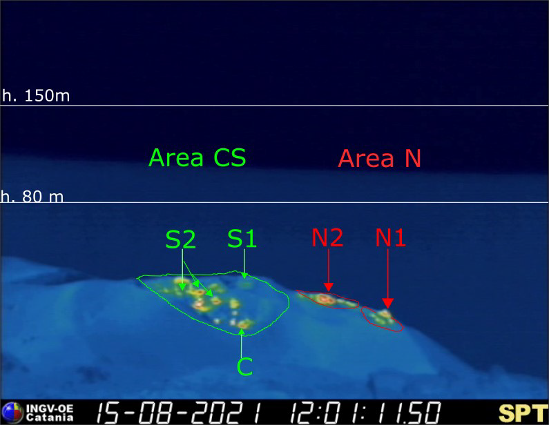
Sector N1, with two emission points, located in the area of the North crater produced explosions of mainly medium-low intensity (sometimes the products of the explosions exceeded 80 m in height) emitting coarse materials (lapilli and bombs) . Sector N2, with three emission points, showed low intensity explosive activity (less than 80 m in height) emitting coarse materials with sometimes intense projection activity on November 3, 5, 6 and 7. The average frequency of explosions varied from 11 to 15 events / h.
In the Center-South zone, sector S1 showed a few sporadic explosions emitting coarse material with low intensity, while the two openings of sector S2 produced explosions, even simultaneously, of low intensity emitting coarse material. It is necessary to underline an intense activity of projection, observed over short periods, in sector S2. Sector C showed sporadically explosive activity emitting coarse materials with low intensity. The frequency of the explosions varied from 5 to 10 events / h
Source : INGV.
Photos : INGV , webcam via Alicja Szojer
Chile , Nevados de Chillán :
– During this period, 101 earthquakes classified as volcano-tectonic (VT) were recorded, associated with fragile rupture processes in volcanic systems; the most energetic earthquake had a local magnitude (ML) equal to 2.4 and it was located 3.4 km east-south-east from the active crater, with a depth of 4.1 km.
– Long period (LP), tremor (TR) and very long period (VLP) seismicity continued to be recorded, associated with fluid dynamics within the volcanic system. 1291 LP-type earthquakes were classified, of which 956 were associated with explosions (EX) due to the presence of acoustic waves and / or frequent gas emissions with input of particles. The size of the largest LP earthquake estimated from the reduced displacement parameter (DR), reaches a value equal to 671 cm2
. In addition, 9 VLP-type earthquakes were detected, the largest of them with a DR equal to 12 cm2
. Regarding the tremor type seismicity, 670 episodes were identified, the most important of which reached a DR value equal to 186 cm2.
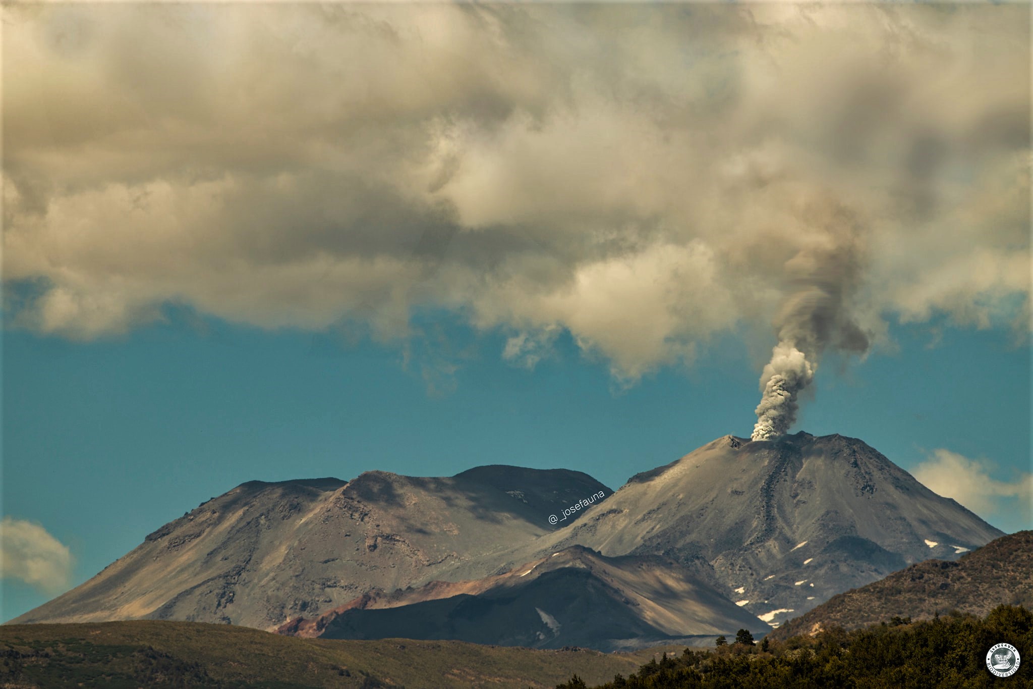
During the second half of October, thanks to surveillance cameras, explosive events were observed from the Nicanor crater, characterized by a certain cyclicity which gave rise to grayish columns, with a moderate content of pyroclasts, and d others of a whitish color rich in water vapor. Compared to the estimated heights, they decreased throughout the fortnight, registering the maximum on October 18 with 1580 m (21:29 UTC).
– On occasion, the energy of the explosions generated fragments of incandescent material on the northern slope, as well as higher energy events which caused the emission of pyroclastic flows in a northeast direction.
Compared to the active effusive bodies descending the northeast slope of the volcano, they continued their development at a slower rate of progress than during the first half of October. The lava flow « L7 », located in the depression located between the inactive lava flows « L5 » and « L6 », reached on October 29 a length of 942 m from its center of emission, with a forward speed of 0.1 m / h. Its second lobe in an east-northeast direction, named « L7B » has not shown any progress since October 14th. The second active stream, called « L8 », reached 382 m in length from its emission center with a speed of 0.02 m / h.

22 thermal alerts were recorded in the area associated with the volcanic complex during the period, with a maximum Volcanic Radiative Power (VRP) of 25 MW on October 22, a value considered moderate according to data processed by the Medium Infrared Observation of MIROVA Volcanic Activity Since October 23, there has been a decrease in the power of thermal anomalies, with values not exceeding 10 MW, until the end of the month. At the same time, analysis of Sentinel 2-L2A images showed radiance anomalies on October 17, 20, 22, 25, 27 and 30, associated with current effusive activity.
Source : Sernageomin.
Read the full article : http://sitiohistorico.sernageomin.cl/reportesVolcanes/20211110013006984RAV_N%CC%83uble_octubre_2021_N%C2%B020.pdf
Photos : Josefauna.
Philippines , Taal :
TAAL VOLCANO BULLETIN 10 November 2021 8:00 AM
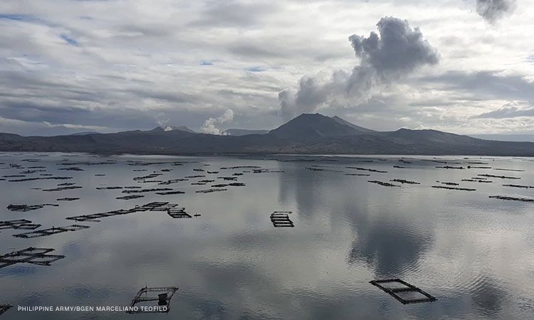
In the past 24-hour period, the Taal Volcano Network recorded one hundred forty-five (145) volcanic earthquakes, including seventy (70) volcanic tremor events having durations of one (1) to two (2) minutes, seventy-two (72) low-frequency volcanic earthquakes, three (3) hybrid events, and low-level background tremor that has persisted since 7 July 2021. Activity at the Main Crater was dominated by upwelling of hot volcanic fluids in its lake which generated plume 1500 meters tall that drifted southwest. Sulfur dioxide (SO2) emission averaged 9,491 tonnes/day on 09 November 2021. Based on ground deformation parameters from electronic tilt, continuous GPS and InSAR monitoring, Taal Volcano Island has begun inflating in August 2021 while the Taal region continues to undergo very slow extension since 2020.
Alert Level 2 (Increased Unrest) prevails over Taal Volcano. DOST-PHIVOLCS reminds the public that at Alert Level 2, sudden steam- or gas-driven explosions, volcanic earthquakes, minor ashfall, and lethal accumulations or expulsions of volcanic gas can occur and threaten areas within and around TVI.
Source : Phivolcs
Photo : CNNPH , Marceliano Teofilo