November 1 , 2021 .
Spain / La Palma , Cumbre Vieja :
October 31, 2021 09:00 UTC. Eruptive activity continues on La Palma.
Since the last press release, 83 earthquakes have been located in the area affected by the volcanic reactivation of Cumbre Vieja. The biggest earthquake was the one located at 1:39 p.m. on the 30th, with a magnitude of 3.5 mbLg and a depth of 13 km.
Four earthquakes were located at depths of about 30 km, the rest of the hypocenters of the period are located at a shallower depth, about 12 km.
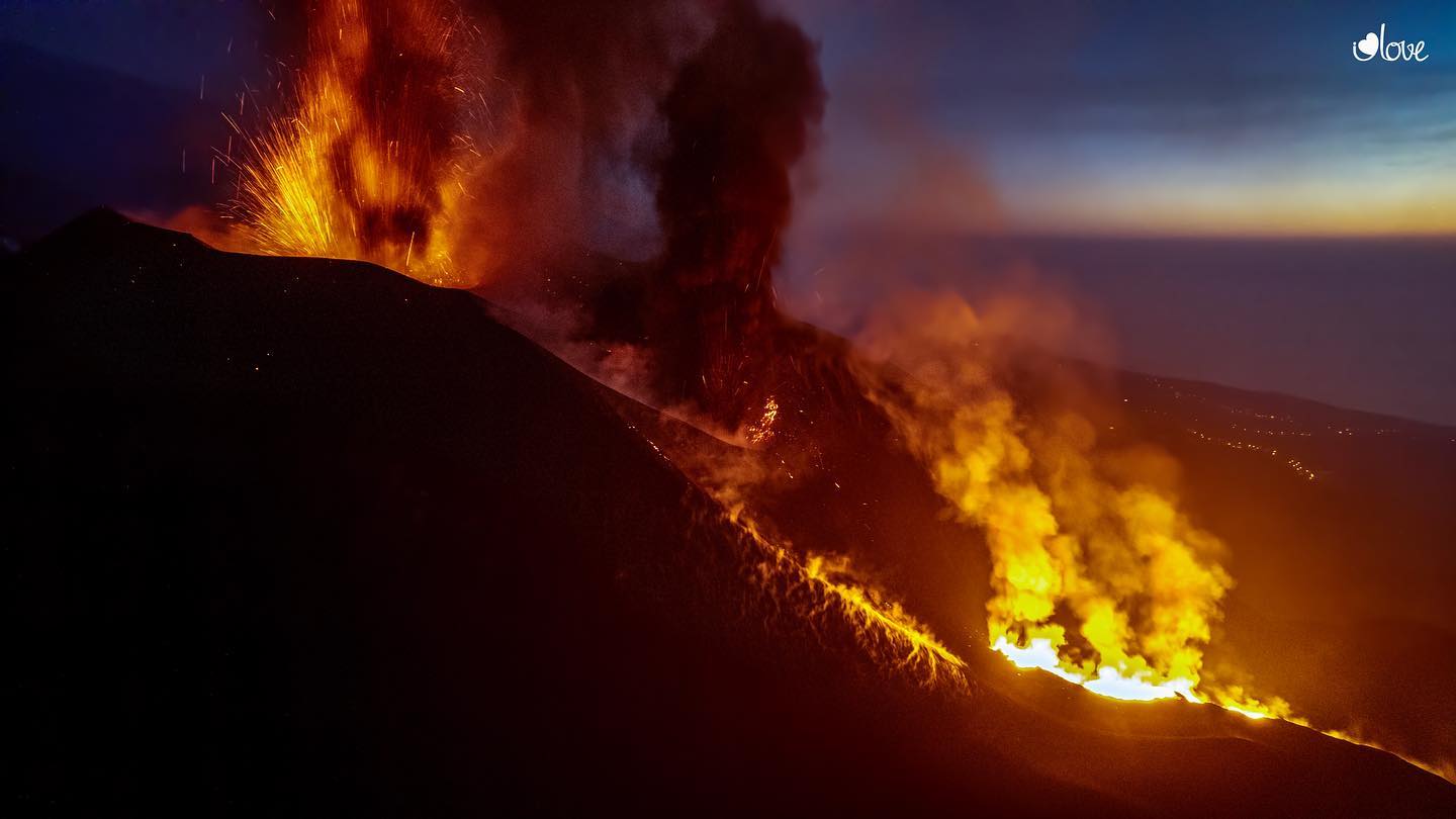
The amplitude of the volcanic tremor signal was maintained at high average levels, with intensifying pulses.
The island’s network of permanent GNSS stations shows a slight deformation to the southwest at station LP03, which is closest to the eruptive centers.
At the most remote stations, a slight deflation persisted, possibly linked to deep seismicity.
In view of the calibrated image, an emission cloud of 4,500 m is estimated at 9:30 UTC.
Image taken from the Cabeza de Vaca runway at 8:00 UTC where the ash column can be seen.
Yesterday October 30 at 19:05 UTC, due to the increase in the height of the volcanic ash cloud, the IGN issued a new VONA message (Volcano Observatory Notice for Aviation) communicating that the said height reached 5,000 m above the sea level.
A second magnitude 5 earthquake was located in La Palma on Sunday, a day when air quality deteriorated in Los Llanos de Aridane, in the southwest of the island. The earthquake recorded this Sunday occurred at 5:52 p.m., with intensity IV, and 38 kilometers deep under the municipality of Villa de Mazo, the same in which on Saturday the National Geographic Institute (IGN) located at 7:24 am a first tremor of magnitude 5, with an intensity IV-V and 35 kilometers of depth.

This new movement came shortly after the scientific committee of the Canary Islands Volcanic Emergency Plan (Pevolca) commented that the volcano gave the impression that the number and magnitude of earthquakes were decreasing.
Sulfur dioxide emissions decline for the sixth day in a row. It is estimated that during the last day approximately 7,700 tonnes were emitted.
Flow number 3, the most active so far, reached Las Hoyas on Saturday, where it came to a stop without advancing towards the sea. 2,162 buildings were destroyed and 146 in danger, according to the European Copernicus satellite system. 280 hectares of crops have been affected, more than half of which are banana plantations. The rest was dedicated to the vines and avocados.
Source : IGN es, El Pais .
Photos : I love the world.
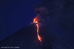
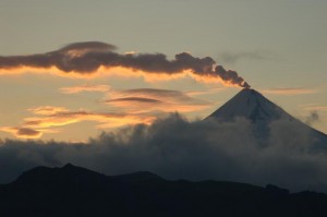
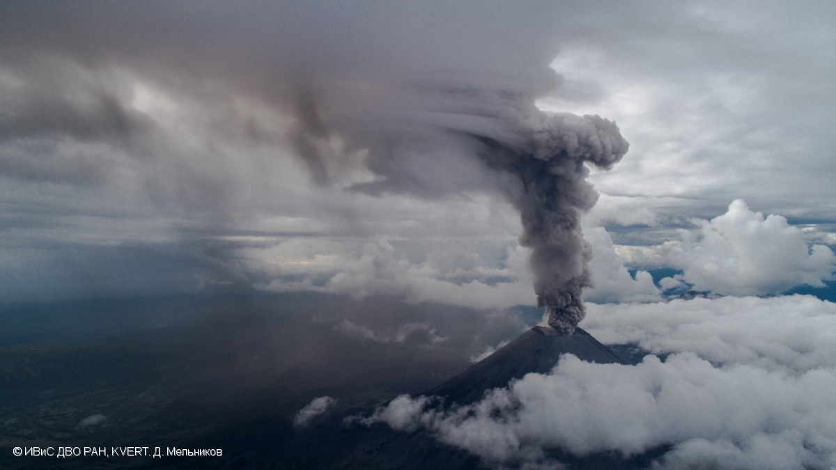
Kamchatka , Karymsky :
VOLCANO OBSERVATORY NOTICE FOR AVIATION (VONA)
Issued: November 01 , 2021.
Volcano: Karymsky (CAVW #300130)
Current aviation colour code: ORANGE
Previous aviation colour code: orange
Source: KVERT
Notice Number: 2021-134
Volcano Location: N 54 deg 2 min E 159 deg 26 min
Area: Kamchatka, Russia
Summit Elevation: 1486 m (4874.08 ft)
Volcanic Activity Summary:
A moderate eruptive activity of the volcano continues. Satellite data by KVERT showed: explosions sent ash up to 3.5 km a.s.l., and ash plume is extending for 50 km to the eastsoutheast of the volcano
This activity of the volcano continues. Ash explosions up to 7-8 km (23,000-26,200 ft) a.s.l. could occur at any time. Ongoing activity could affect international and low-flying aircrafts.
Volcanic cloud height:
3500 m (11480 ft) AMSL Time and method of ash plume/cloud height determination: 20211101/0330Z – Himawari-8
Other volcanic cloud information:
Distance of ash plume/cloud of the volcano: 50 km (31 mi)
Direction of drift of ash plume/cloud of the volcano: ESE / azimuth 120 deg
Time and method of ash plume/cloud determination: 20211101/0330Z – Himawari-8.
Source : Kvert.
Photo : D. Melnikov, IVS FEB RAS, KVERT.
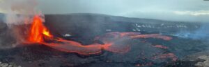
Hawaii , Kilauea :
19°25’16 » N 155°17’13 » W,
Summit Elevation 4091 ft (1247 m)
Current Volcano Alert Level: WATCH
Current Aviation Color Code: ORANGE
Activity Summary:
Kīlauea volcano is erupting. As of this morning, October 31, 2021, lava continues to erupt from a single vent in the western wall of Halemaʻumaʻu crater. All lava activity is confined within Halemaʻumaʻu crater in Hawai‘i Volcanoes National Park. Seismic activity and volcanic gas emission rates remain elevated.
Summit Observations:
Sulfur dioxide (SO2) emission rates remain high, with a preliminary emission rate for October 28, 2021, of at least 3,600 tonnes per day. No significant changes seen in summit tilt or GPS observations. Earthquake activity remains below background and volcanic tremor remains elevated since the beginning of the eruption.
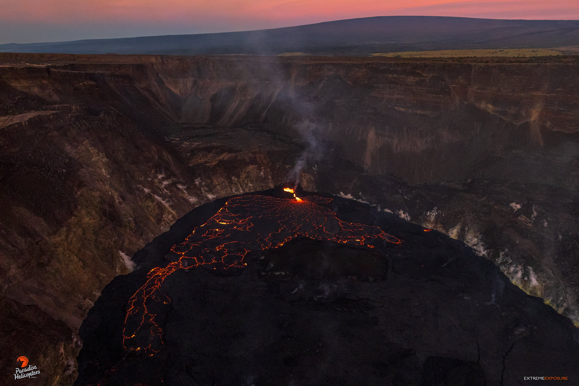
Halemaʻumaʻu Lava Lake Observations:
Lava continues to erupt from a single vent in the western wall of Halemaʻumaʻu crater. The western end of the lake showed a maximum elevation of approximately 795 meters (2608 ft) above sea level by HVO’s permanent laser rangefinder on October 31, 2021, which is about the same as yesterday, and a total increase of about 51 meters (167 ft) since lava emerged on September 29. The total erupted volume since the beginning of the eruption was estimated to be about 19.9 million cubic meters (5.3 billion gallons) on October 15. Lava fountaining has been replaced by low roiling and spatter bursting at the western vent as observed by field crews on October 29, 2021. The lava lake is not level across its surface due to the location of the vent in the western end. There is about 8 meters (26 feet) elevation difference between the active west and stagnant east part of the lake as measured by field crews on October 27, 2021.
Source : HVO
Photos : Bruce Omori / Paradise helicopters .
Costa Rica : Rincon de la Vieja / Turrialba / Poas / Tenorio / Barva :
Volcanic Watch Program Weekly Bulletin
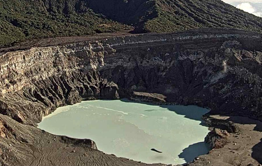
Rincón de la Vieja volcano
Lat: 10.83 ° N; Long: 85.324 ° W;
Height: 1895 m
Current activity level: 3 (erupting volcano)
Potentially associated hazards: Lahars, gas, phreatic eruptions, Proximal ballistic projections, ash fall, acid rain.
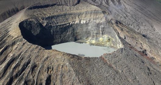
The last phreatic eruption was recorded on October 14. A slight increase was observed in the weekly number of LP-type earthquakes (around 30 events). The other seismic parameters such as the number of « tornillos » type events (6 events) and VTs type earthquakes (6 events) remain stable. Some VT type events could be located near Las Pailas, southwest of the crater. GPS geodetic monitoring shows a slight tendency for the base of the volcano to contract.
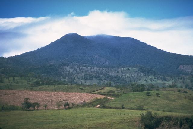
Turrialba volcano
Lat: 10.025 ° N; Long: 83.767 ° W;
Height: 3340 m
Current activity level: 2 (active volcano)
Potentially associated hazards: gas, ash emission, Proximal ballistic projections, acid rain.
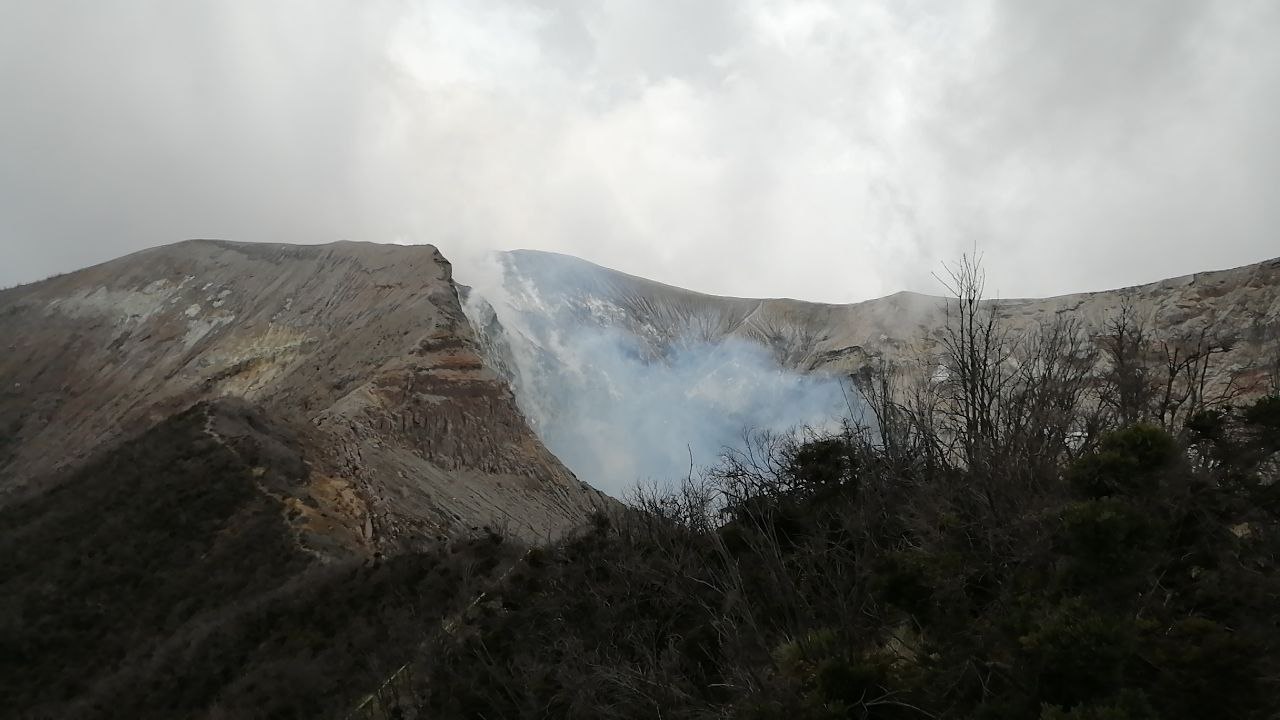
The number of proximal VT-type events increased (10 events) last week without being a significant change. The other seismic parameters are stable (100 low frequency type events). Geodetic monitoring shows a contraction in the region comprising the Irazú-Turrialba massif over the last 4 months, centered under the Irazú volcano. The CO2 / SO2 and H2S / SO2 gas ratios remain similar to the previous week (CO2 / SO2 = 18.9 +/- 1.5, H2S / SO2 = 0.26 +/- 0.04). The flow of SO2 has increased compared to the previous week but still remains at a low level (88 +/- 88 t / d). Air quality monitoring carried out through the OVSICORI-UNA aerosol and volcanic gas monitoring station located in San Isidro de Coronado, shows a very low concentration of SO2, almost undetectable (0.2 ppb) on 24 and October 25.
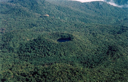
Poas volcano
Lat: 10.2 ° N; Long: 84.233 ° W;
Height: 2780 m.s.n.m.
Current activity level: 2 (active volcano)
Potentially associated hazards: gas, phreatic eruptions, Proximal ballistic projections, acid rain.
No phreatic eruption was observed. The seismic activity (weekly number of events of type LPs 1200, VTs and short tremor) remains stable, under normal variations. A few proximal VT-type events (4 events) were recorded in October, and distal seismicity in the region including the Porvenir-Poás-Barva volcanoes. The frequency of the appearance of bubbles in the hyperacid lake markedly decreased, the manifestation was observed just 1-2 times a day. The geodetic monitoring again shows a slight tendency to extend at the top of the volcano. A slight increase in the gas concentration was recorded in the multiGAS station, allowing the calculation of the ratios, which remain stable (SO2 / CO2 = 0.41 +/- 0.13, H2S / SO2 = 0.02 +/- 0.02). The SO2 flow remains very low, with only 29 +/- 17 t / d being calculated. The concentration of SO2 in the fumaroles detected by the EXPOGAS alarm system had a maximum of 1.7 ppm on October 22. The level of the hyperacid lake remained stable during the week, as did the rate of evaporation / infiltration. Fumaroles in the eastern sector of the active crater continue to show low water vapor flow and low temperature.
Tenorio volcano
Lat: 10.673 ° N; Long: 85.015 ° W;
Altitude: 1916 m
Current activity level: 0 (dormant volcano)
Potentially associated risks: earthquakes.
A few proximal VT-type events were recorded (3 events).
Barva volcano
Lat: 10135 ° N; Long: 84.1 ° W;
Altitude: 2906 m
Current activity level: 0 (dormant volcano)
Potentially associated risks: earthquakes.
Some proximal and distal TV-type events have been recorded, in particular between the Barva volcano and the Poás volcano (6 events)
Source : Ovsicori.
Photos : Chris Allen / Sunquest Helitours , Jean Paul Calvo/ RSN , Ovsicori , Wikipedia , Wikiloc / evega.
Guatemala , Fuego :
Activity:
The Fuego volcano observatory reports 6 to 10 weak, moderate or strong explosions per hour, which raise columns of gray ash to heights of 4,500 to 4,700 m above sea level (14,764 to 15,420 feet), which disperse southwest and south up to 15 kilometers away. Ash falls are noted on Panimaché I and II, Morelia, Santa Sofía, El Porvenir, La Rochela and other communities in these directions. The explosions produced moderate avalanches towards the ravines of Ceniza, Taniluyá, Santa Teresa and Las Lajas, some reaching the edge of the vegetation.

During the night and early in the morning, the explosions raised incandescent materials to heights of up to 400 meters above the crater. These explosions are accompanied by weak, moderate to strong rumblings with shock waves that vibrate the roofs and windows of the houses of the communities near the volcano. Faint degassing sounds were heard for periods of 2-4 minutes.
Source : Insivumeh
Photo : @davidrojasgtfoto