October 23 , 2021 .
Spain / La Palma , Cumbre Vieja :
October 22, 2021 08:00 UTC. Eruptive activity continues on La Palma.
Since the last declaration, 135 earthquakes have been located in the area affected by the volcanic reactivation of Cumbre Vieja, 14 of these earthquakes were felt by the population, the maximum intensity being in the epicentral zone IV (EMS98) , in the earthquakes that occurred at 22:54 UTC on the 21st, with a magnitude of 4.4 mbLg and at 6:54 a.m. today, with a magnitude of 4.2 mbLg and depths of 33 and 38 km respectively.
The earthquake of 22:54 on the 21st (4.4 mbLg) is the largest earthquake of the period considered.
Only two earthquakes were located at a depth of about 30 km, the rest of the hypocenters of the period are located at a shallower depth, about 12 km.
The volcanic tremor signal maintains a high average amplitude, without intensification pulses.
The height of the emission column measured at 08:00 UTC is estimated at 2,800 m.
The island’s network of permanent GNSS stations still does not show a clear tendency to warp from stations closest to eruptive centers, while at more distant stations a slight deflation is maintained, possibly related to deep seismicity. .
The eruption of the volcano La Palma continues to be Strombolian in character and is in an effusive phase, at a value of 2 on a scale of 8 at most, as explained by Carmen López, responsible for the Volcanic Monitoring of the Institute. national geographic (IGN). Here are the most notable data on the evolution of the rash:
· The cone emission centers continue to be active with the expulsion of pyroclasts intermittently and with less explosiveness. Lava emissions have less flow. The advance of the flows has decreased, but their thickness has increased.
· The appearance of new emission points is not excluded.
· The height of the column of ash and gas reached 2,800 meters on Friday. The ash cloud and sulfur dioxide are expected to move west over the next morning.
· Earthquakes may reach an intensity of 6 and cause landslides in sloping areas.
· Sulfur dioxide emission has been calculated at 28,475 tonnes per day.
Source : IGN es , El Pais .
Photos : Instituto Geológico y Minero de España / El Pais
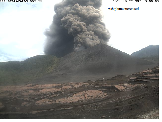
Vanuatu Archipelago , Yasur :
19°32’0”S 169°26’30”E
Summit 1184ft (361m)
Current Vanuatu Volcano Alert Level: Level 2
Yasur volcano activity has intensified in the Level of major unrest state. The Volcanic Alert Level remains at Level 2.
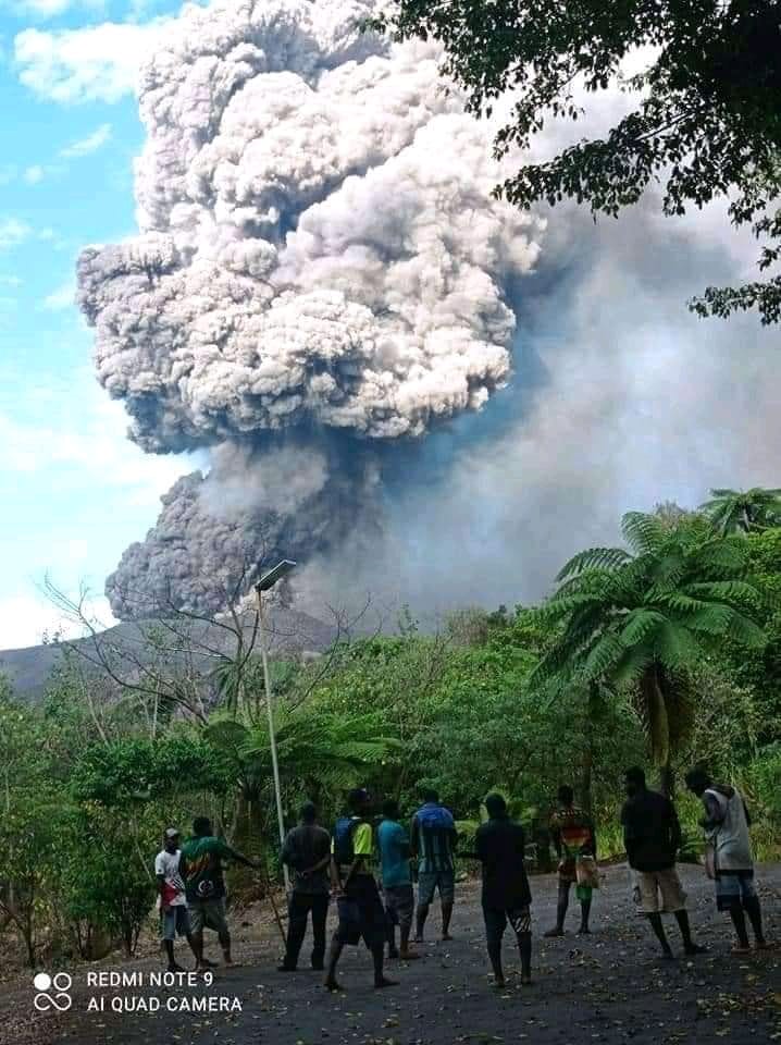
New observations on the ground indicate that the Yasur volcanic has emitted massive plumes of volcanic gases and ash that was observed at 2:30 pm on the 22nd of October 2021. With the emission of massive volcanic gases and ash, the danger zone is increased to 1 KM around the volcano cone. The danger zone for life safety is moved to Danger Zone B (See Yasur caldera safety map below).
Latest Analysis of the Yasur seismic data from the volcano monitoring system confirms that Yasur volcano activity has intensified, however volcanic alert level remains at level 2. The activity consists of ongoing massive emissions of volcanic gas and ash plumes. Some explosions remain intensified and volcanic projectiles or bombs may fall in and around the summit crater.
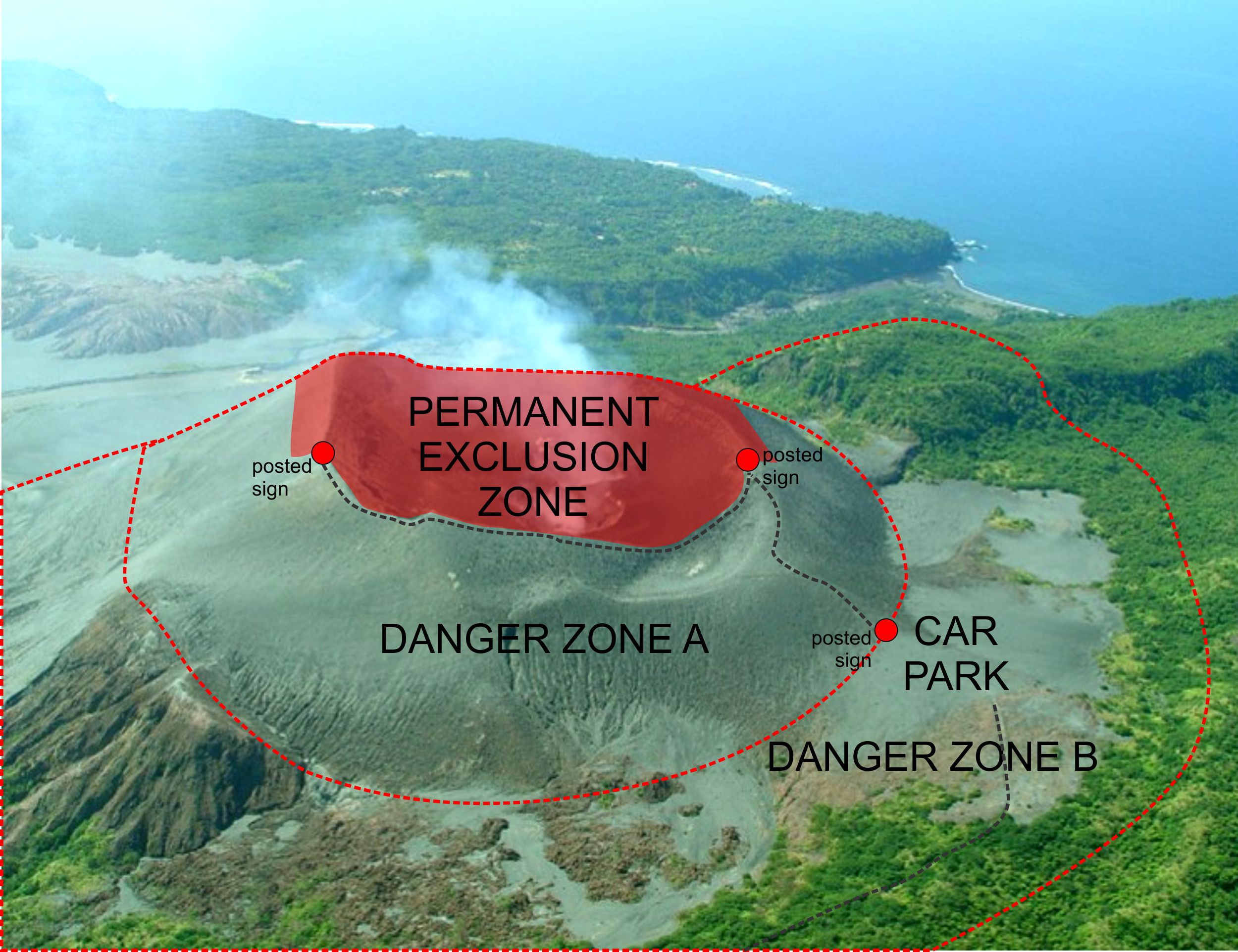
The Yasur Volcanic Alert Level (VAL) has remained in Level 2 since the 18th October 2016. The current observations are consistent with the activity of the Volcanic Alert Level 2. Level 2 indicates ‘Major level of unrest; Danger zone has increased to 1 Km around the volcanic cone. With this current volcanic activity, it is a useful reminder that eruptions can occur with little or no warning.
Advice to all tourism agencies, visitors, local authorities, people from Tanna Island and general public that with this current activity and massive emissions of volcanic gases and ash plumes around the crater and following the wind direction, the danger zone (Danger Zone has increased to 1 km around the volcano cone. The level of risk for visitors accessing areas from the crater rim to the parking area (Danger Zone A) remains high. With this current level of activity, villages located close to the volcano may continue to expect volcanic gases and/or ash falls impacts, especially those exposed to the wind direction.
Source : Geohazard Vanuatu.
Photos : Haos Blong Volkeno via Sherine France , Geohazard Vanuatu. Vanuatu Meteorology and Geo-hazards Department
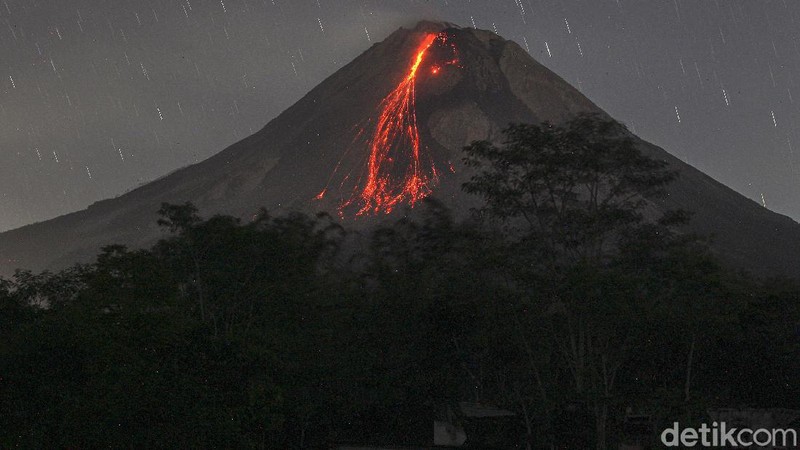
Indonesia , Merapi :
Mount Merapi Activity Report, October 15-21, 2021
OBSERVATION / RESULT
Visual
The weather around Mount Merapi is generally sunny in the morning and evening, while it is foggy in the afternoon. White, weak to thick, low pressure, 700m high fumes were observed from the Mount Merapi de Selo observation post on October 19, 2021 at 07:30 WIB.
This week, there were 2 hot avalanches with an estimated maximum slide distance of 2,500 m to the southwest. It was reported that there was light ash rains in the Selo district area. Lava avalanches have been observed 60 times to the southwest with a maximum slide distance of 2,000 m.
No significant morphological change was observed in either the southwest dome or the central dome. The volume of the southwest lava dome is 1,609,000 m3 and the central dome is 2,927,000 m3.
Seismicity
This week, the seismicity of Mount Merapi showed
2 hot cloud avalanches (APG),
4 shallow volcanic earthquakes (VTB),
22 low frequency (LF) earthquakes,
583 multi-phase earthquakes (MP),
1363 Avalanche earthquakes (RF),
110 emission earthquakes (DG),
7 tectonic earthquakes (TT).
The intensity of this week’s seismicity is still quite high.
Deformation
The deformation of Mount Merapi which was monitored using EDM and GPS this week showed no significant changes.
Rain and lahars
This week, it rained at the Mount Merapi observation post with an intensity of 39 mm / hour for 95 minutes at Kaliurang post on October 19, 2021, an increase in flow was reported in the Gendol, Boyong and Bebeng rivers. .
Conclusion
Based on the results of visual and instrumental observations, it is concluded that:
The volcanic activity of Mount Merapi is still quite high in the form of effusive eruption activity. The status of the activity is defined in the “SIAGA” level.
Source : BPPTKG
Photo : detik .com
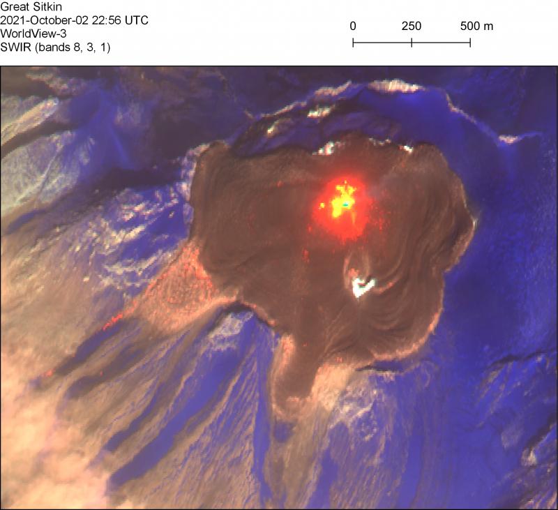
Alaska , Great Sitkin :
52°4’35 » N 176°6’39 » W,
Summit Elevation 5709 ft (1740 m)
Current Volcano Alert Level: WATCH
Current Aviation Color Code: ORANGE
Lava effusion continued this week at Great Sitkin, and lava fills more than half of the summit crater. Satellite imagery through October 20 showed that two lobes of lava, flowing over low points on the crater rim, extend downslope ~500 m (1,600 feet) to the south and west. Lava has also reached the crater rim on its northern periphery. In a few areas, the lava has advanced over snow and is advancing into the glacial ice to the east, but no significant steaming or ponding of water has been observed. This indicates that melt rates are probably low and there are no indications of any imminent hydrologic hazards.
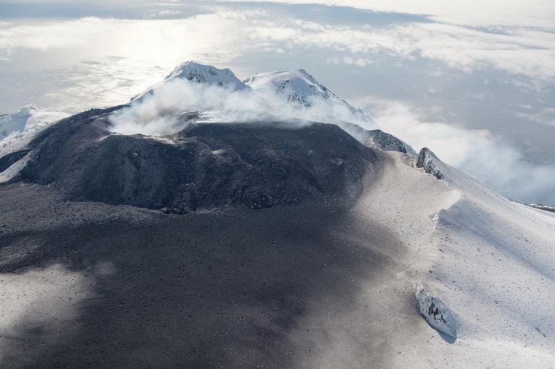
The lava lobes that have overtopped the summit crater rim are flowing into small valleys developed on the volcanic edifice. The terrain is steep in these areas, and blocks of lava and lava rubble could detach from the terminus of the flow lobes without warning and form small rock avalanches in these valleys. Such avalanches may liberate ash and gas and could travel several hundred meters beyond the lava flows; they would be hazardous to anyone in those areas. Satellite imagery shows such a blocky deposit extending downslope beyond the terminus of the west flow lobe.
Local geophysical and web camera data have been unavailable since October 16 due to a power outage in Adak, Alaska, that has not yet been resolved. No explosive activity or ash emissions have been detected in regional seismic, infrasound, or satellite data.
There is no indication of how long lava effusion will continue during the current eruption, and it is possible that explosive activity could occur with little or no warning.
Great Sitkin Volcano is monitored by local seismic and infrasound sensors, satellite data, web cameras, and remote infrasound and lightning networks.
Source : AVO.
Photos : Loewen, Matt ( June 2021) , Loewen, Matt ( WorldView-3 SWIR on October 2, 2021.)
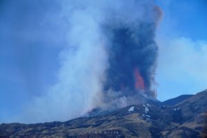
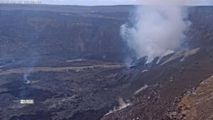
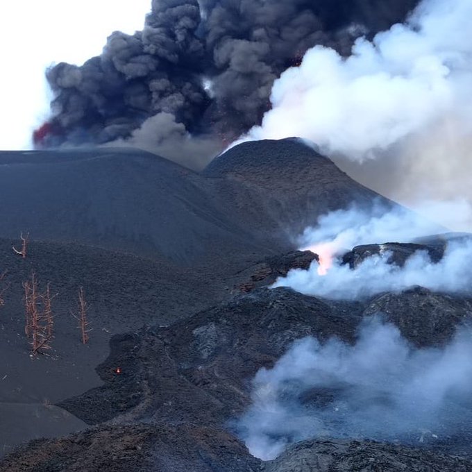
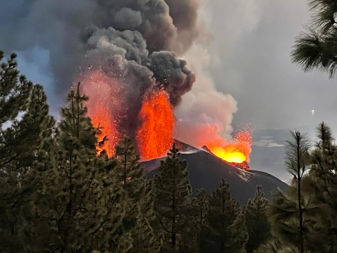
Italy / Sicily , Etna :
Communication on ETNA activity, 22 October 2021, 23:50 (21:50 UTC).
The National Institute of Geophysics and Volcanology, Osservatorio Etneo, announces that the average amplitude of the volcanic tremor continues the gradual upward trend, currently settling in the range of medium-high values. The sources of the tremor are located under the Southeast Crater at a depth of about 2900 m above sea level. At the same time, infrasound activity increases with sources located mainly in the Southeast Crater .
Currently, the unfavorable weather conditions allow an extremely discontinuous and partial display of the phenomenon in progress. In particular, from the visible camera of Montagnola and sometimes that of Monte Cagliato, one can glimpse frequent intermittent lightning, compatible with a probable Strombolian activity.
Soil deformation monitoring networks do not show significant variations.

Communication on ETNA activity, 23 October 2021, 08:23 (06:23 UTC).
The National Institute of Geophysics and Volcanology, Etneo Observatory, reports that at 05.40 UTC the amplitude of the volcanic tremor is high.
The last location of the tremor, at 04.45 UTC, is in the vicinity of the Southeast Crater at a depth of about 3.0 km s.l.m.
The number of infrasonic events in the last 10 minutes, at 05.38 UTC, is very high.
The last infrasonic event is located near the Southeast Crater.
The cloud cover allows for an extremely discontinuous and partial view of the summit area. During the night it was still possible to observe the glows described in the previous press release. On the basis of the forecast model, the ash emitted by the ongoing activity is dispersed in the East / North-East direction.
Soil deformation monitoring networks show no significant variations. Only the Cratere del Piano clinometric station shows a slight trend variation.
Further updates will be communicated shortly.
Source : INGV.
Photo : Gio Giusa.