October 11 , 2021.
Spain / La Palma , Cumbre Vieja :
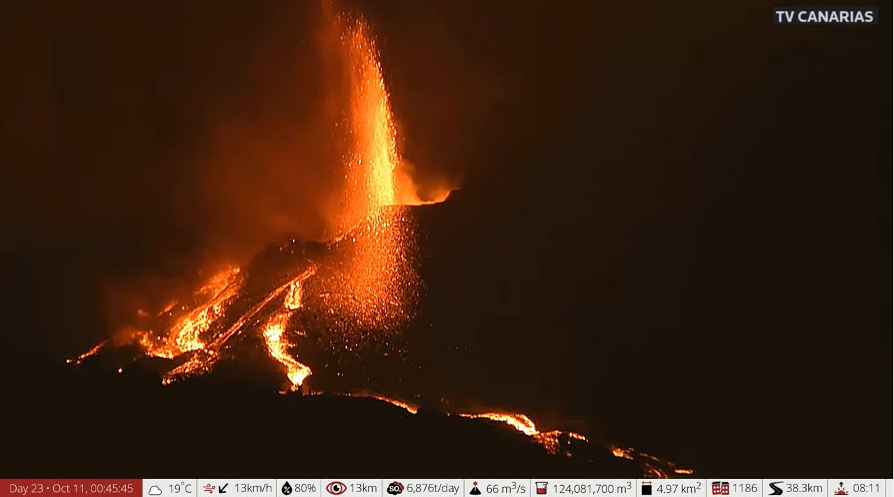
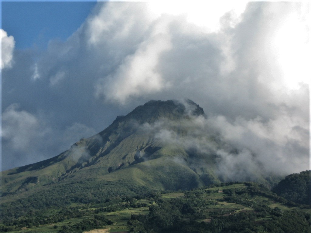
October 10, 2021 12:00 UTC, Eruptive activity continues on La Palma.
Since the last declaration, 214 earthquakes have been located in the area affected by the volcanic reactivation of Cumbre Vieja, 19 of these earthquakes were felt by the population, the maximum intensity being in the epicentral zone IV (EMS98) , with an earthquake that occurred at 20:54 UTC on the 9th, with a magnitude of 3.6 (mbLg) at a depth of 11 km.
The highest magnitude earthquake occurred at 11:55 p.m. on the 8th, with a value of 4.2 mbLg at a depth of 38 km
Of the earthquakes located since the last report, 39 are at depths greater than 30 km, the rest of the hypocenters are located at a shallower depth, around 12 km.
The average amplitude of the volcanic tremor remains stable within a range of average values compared to the observations measured during this eruption. No intensification pulse has been recorded since the last report.
The height of the column measured at 6.30 UTC is 3,500 m, showing a slight decrease in the eruptive cloud.
The island’s network of permanent GNSS stations shows stability in the deformations of stations close to eruptive centers.
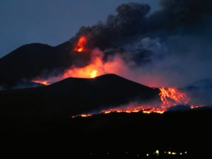
Cone break expands La Palma volcano’s destructive power
The volcano of La Palma once again shows its destructive power. The rupture of the cone in its northern part, which occurred this Saturday, caused a « significant increase » in expelled flows, accompanied by « large blocks », announced Sunday the spokespersons of the steering and scientific committee of the Plan d volcanic emergency in the Canaries (Pevolca), Miguel Angel Morcuende and Maria José Banco. As a main consequence, the eruption resumed in front of the dwellings, advancing on the industrial zone of El Callejón de la Gata (Los Llanos de Aridane) and destroying the few buildings that remained north of Todoque, one of the localities that has almost completely disappeared, as the Canary Islands Volcanological Institute (Involcan) reported on Sunday.
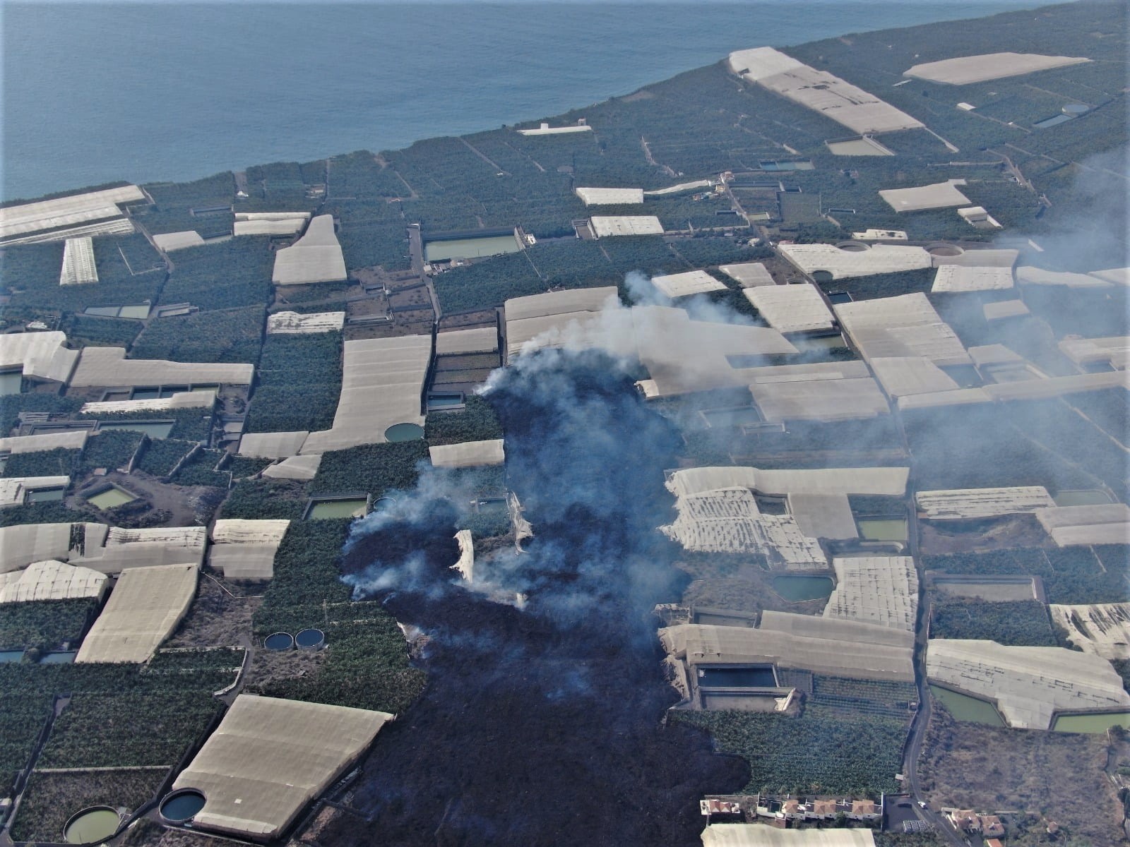
The flow that worries scientists the most at the moment is the one located south of the cone, having been close to the main one, because it is a large mass of lava, explains the Department of Homeland Security in its latest update. The collapse of the northern flank of the Cumbre Vieja volcano caused the release of large blocks of material and the appearance of new flows that pass through areas already evacuated. The lava reached the Camino de la Gata industrial zone and reached new buildings, affecting an area of 497 hectares, 20.9 more than yesterday. The lava delta is still expanding in a North-South direction and already covers an area of 34 hectares. Air quality is improving from previous days and is expected to continue this Sunday.
Sources : IGN , El Pais.
Photos : TV Canarias , Rainer Tietel .
Hawaii , Kilauea :
19°25’16 » N 155°17’13 » W,
Summit Elevation 4091 ft (1247 m)
Current Volcano Alert Level: WATCH
Current Aviation Color Code: ORANGE
Activity Summary:
Kīlauea volcano is erupting. As of this morning, October 10, 2021, lava continues to erupt from a single vent in the western wall of Halemaʻumaʻu crater. All lava activity is confined within Halemaʻumaʻu crater in Hawai‘i Volcanoes National Park. Seismicity and volcanic gas emission rates remain elevated.
Summit Observations:
Sulfur dioxide (SO2) emission rates remain high, with a measured emission rate of approximately 5,300 tonnes per day on October 8, 2021, similar to the measurements of the last few days. Seismicity remains elevated but stable. Summit tiltmeters continue to record deflationary tilt.
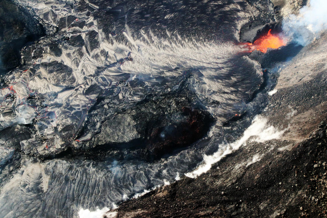
In this overflight photo of the Halema‘uma‘u lava lake, captured on October 8, 2021 and looking from the northeast, two western fissures are visible: one inactive from the December 2020–May 2021 Kīlauea summit eruption (center), and another actively feeding lava into the lake at this time (upper-right). The older fissure is is being partially overlapped by short lava flows, but it has not been completely drowned because field measurements show that it is floating within the lake. The presently erupting fissure has formed a horseshoe-shaped spatter cone around its source.
Halemaʻumaʻu Lava Lake Observations:
Lava continues to erupt from a single vent in the western wall of Halemaʻumaʻu crater. The western end of the lake shows a maximum elevation of approximately 780 meters (2559 ft) above sea level as measured by field crews on October 9, which is a 1 meter (3ft) increase over the past day and a total increase of about 37 meters (121 ft) since lava emerged on September 29. The total erupted volume is estimated to be about 15.9 million cubic meters since the beginning of the eruption. The western vent continues to have sustained lava fountain heights of about 15 meters (49 ft) and the fountain has built a spatter cone with an approximately 10 meter (33 ft) wide opening facing east towards the lake.
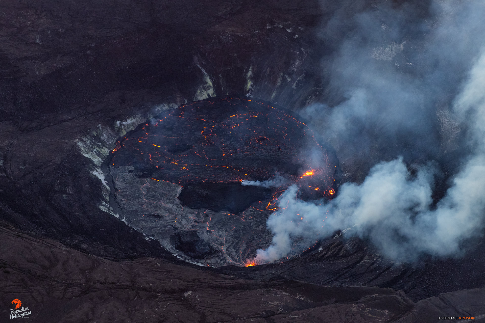
Lava is feeding into the lake from a flow out of the spatter cone opening. The central island and several of the smaller eastern islets from the 2020 lava lake are still above the lake surface along with an island of the 2020 western vent rampart in the northwest part of the lake. The lava lake is not level across its surface due to the location of the vent in the western end. Areas closer to the vent are about 1-2 meters (3-7 ft) higher in elevation compared to the north and south part of the lake and 8 meters (26 ft) higher than the east end of the lava lake. Crustal foundering is mainly focused on the western part of the lava lake with lava flowing north and south around the central island through narrow cascades to reach parts of the eastern end of the lake.
Source : HVO
Photo : USGS
Indonesia , Semeru :
VOLCANO OBSERVATORY NOTICE FOR AVIATION – VONA
Issued : October 10 , 2021
Volcano : Semeru (263300)
Current Aviation Colour Code : ORANGE
Previous Aviation Colour Code : orange
Source : Semeru Volcano Observatory
Notice Number : 2021SMR58
Volcano Location : S 08 deg 06 min 29 sec E 112 deg 55 min 12 sec
Area : East java, Indonesia
Summit Elevation : 11763 FT (3676 M)
Volcanic Activity Summary :
Eruption with volcanic ash cloud at 23h02 UTC (06h02 local). Eruption and ash emission is continuing.
Volcanic Cloud Height :
Best estimate of ash-cloud top is around 12723 FT (3976 M) above sea level, may be higher than what can be observed clearly. Source of height data: ground observer.
Other Volcanic Cloud Information :
Ash-cloud moving to southwest
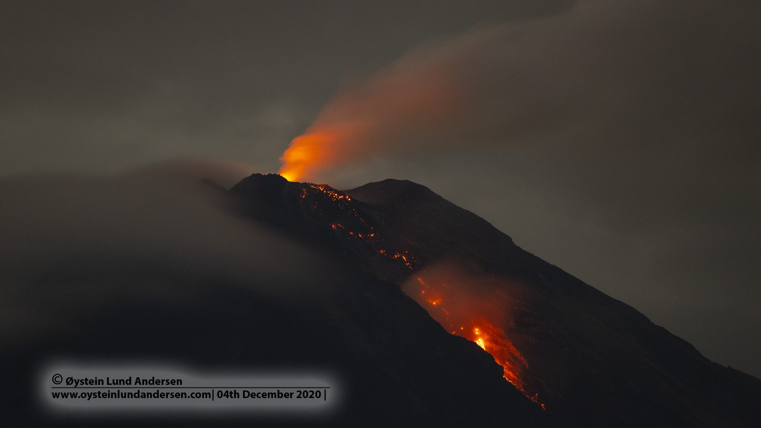
Level of activity at level II (WASPADA) since May 2, 2012. The Semeru volcano (3676 m above sea level) erupts intermittently. There are explosive and effusive eruptions, producing lava flows towards the southern and southeastern slopes, as well as projections of incandescent rocks around the summit crater.
The volcano is covered in fog. No smoke from the crater was observed. The weather is cloudy, the wind is weak in the West. The air temperature is around 20-27 ° C. The rash always occurs without the rash column being observed.
According to the seismographs of October 10, 2021, it was recorded:
61 eruption earthquakes / explosions
15 earthquakes of emissions
Sources : Magma Indonésie , PVMBG.
Photo : Oystein lund Andersen .
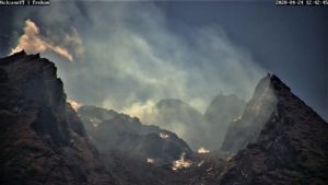
La Martinique , Montagne Pelée :
Weekly report on the activity of Mount Pelée for the period from 01 to 08 October 2021.
Between October 01, 2021 at 4 p.m. (UTC) and October 08, 2021 at 4 p.m. (UTC), OVSM recorded at least 7 volcano-tectonic earthquakes of magnitude less than or equal to 0.1. These earthquakes were located inside the volcanic edifice between 0.1 and 0.9 km below sea level. None of these earthquakes were felt by the population. This volcano-tectonic-type superficial seismicity is associated with the formation of micro-fractures in the volcanic edifice.
A degassing zone at sea was detected at shallow depth (between St Pierre and le Prêcheur). The IGP is currently setting up experiments to map this gas emanation zone, carry out physicochemical measurements of the fluids and samples of these fluids in order to understand the origin of this degassing and to assess its possible relationship. with the hydrothermal system of Mount Pelée. This kind of manifestation is frequent on active or not active underwater volcanic sites. The analyzes underway by the OVSM-IPGP will make it possible to determine the possible relationship of this underwater degassing with the activity of Mount Pelée recorded by the OVSM since 2019.
A main area of heavily degraded vegetation is still observed on the southwest flank of Mount Pelée, between the upper Claire River and the Chaude River.
The alert level remains YELLOW: vigilance.
Source : Direction of l’OVSM IPGP.
Photo : Jmp48 / Wikipedia
Iceland , Reykjanes Péninsula :
About 200 earthquakes in the last 24 hours
About 200 earthquakes have been detected since midnight southwest of Keilir. It is a similar process to that of the last few days. No major earthquakes have been detected near Askja since yesterday. In yesterday’s news it was said that the earthquake, which measured M3, was the largest on Askja at least since the turn of the century. The truth is that such earthquakes have not been detected northwest of Askja yet. It is to the east and south of Askja that such earthquakes have been detected.

Yesterday, a magnitude 3 earthquake was measured about 7 kilometers northwest of Öskjuvatn at 8:23 am. The earthquake occurred at a depth of about 2.6 kilometers.
Sources : RUV , IMO