July 16 , 2021.
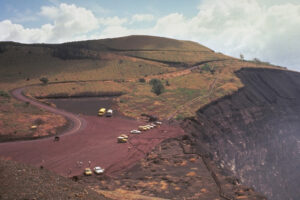
Italy / Sicily , Etna :
PRESS RELEASE ON THE ACTIVITY OF ETNA, July 14, 2021, 11:52 (09:52 UTC).
The National Institute of Geophysics and Volcanology, Osservatorio Etneo, announces that from approximately 09:05 UTC this July 14, we observe the resumption of Strombolian activity at the level of the Southeast Crater. According to the forecast model, the volcanic ash produced by the current activity is dispersed in the northeast direction.
From approximately 07:50 UTC, an increase in the average amplitude of the volcanic tremor is observed, the values of which are currently in the medium-high level. The sources of the tremor are located in the Southeast Crater at a depth of about 2900 m above sea level. The rate of occurrence of infrasonic events is low.
Etna’s GPS and inclinometric networks do not show significant variations.
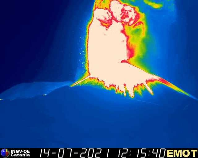
PRESS RELEASE ON THE ACTIVITY OF ETNA, July 14, 2021, 13:01 (11:01 UTC).
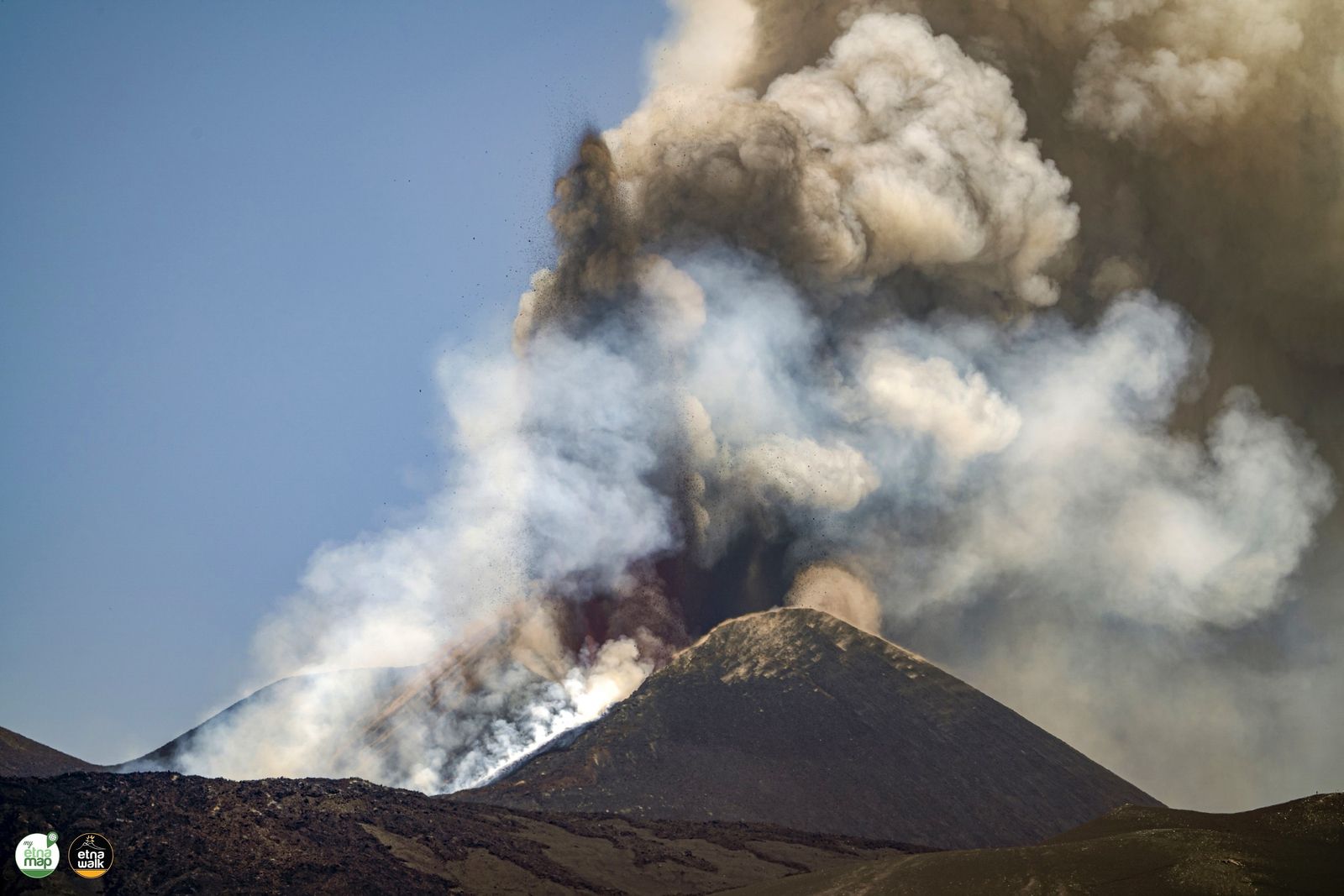
The National Institute of Geophysics and Volcanology, Osservatorio Etneo, reports that the gradual passage of Strombolian activity to the lava fountain stage from the Southeast Crater is observed. The eruptive cloud reaches a height of about 5500 m above sea level. According to the forecast model, the eruptive cloud produced by the current activity disperses in the northeast direction.
The trend of increasing the average amplitude of volcanic tremor continues in the high value range. The infrasonic activity also intensified in both the rate of occurrence and the energy of infrasonic events. The sources of volcanic tremor and infrasound events are located at the Southeast Crater.
Soil deformation networks do not show significant variations.
An overflow of lava directed towards the South-West from the South-East Crater is observed by the staff of INGV present on the ground.
PRESS RELEASE ON THE ACTIVITY OF ETNA, July 14, 2021, 2:30 pm (12:30 UTC).
The National Institute of Geophysics and Volcanology, Osservatorio Etneo, reports that analysis of CCTV images and satellite cameras shows that the eruptive cloud, from around 11:40 UTC, reached a height of over 9,000 m and heads northeast. INGV field staff also reported the fallout from large bombs on the southern flank of the Bocca Nuova crater.
The tendency to increase the mean amplitude of the volcanic tremor continues with very high values. The centroid of volcanic tremor sources is located in the Southeast Crater region at an altitude of about 2900-3000 m.
The infrasound activity shows a high frequency of occurrence of events, which are located in correspondence with the Southeast Crater and show slightly increasing average amplitude values.
Coinciding with the lava fountains episode, modest inclinometric variations are recorded, with a maximum of around 1 microradian recorded by the Cratere del Piano station (ECP).

From 12:30 UTC, the lava fountain of the Southeast Crater ceased. From the analysis of satellite images, it is observed that the volcanic cloud moved northeast and reached the Calabrian coast from 12:20 UTC. INGV staff present in the field reported abundant fallout of lapilli and ash (thickness greater than 1 cm) in the district of Rocca Campana. There are reports of volcanic ash and lapilli fallout at Rifugio Citelli and Presa and volcanic ash at Taormina. A weak Strombolian activity remains at the level of the Southeast Crater. In addition, the lava flow in the southwest sector remains fed.
Source : INGV.
Photos : INGV, Etna Walk / Giuseppe Distefano / Marco Restivo , Alessandra Pozzana .
Italy , Stromboli :
PRESS RELEASE ON THE ACTIVITY OF STROMBOLI, July 14, 2021,16:23, (14:23 UTC).
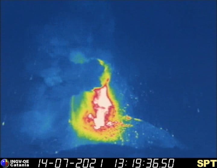
The National Institute of Geophysics and Volcanology, Osservatorio Etneo, announces that at 13:19 UTC there is an explosion energetically more intense than usual in the South Center area. The products fell along the Sciara del Fuoco and also reached the Pizzo area. Seismically, the explosive event at 13:19 UTC is clearly visible from all seismic stations in Stromboli. Regarding the amplitude of the volcanic tremor, an increase was observed from 12:30 UTC with a maximum peak on medium-high values around 13:00 UTC. Currently, the amplitude of the tremor has returned to medium-low values. The signals from the GPS network and the inclinometric network of Stromboli, referring to the last 24 hours, do not show significant variations.
14 July 2021, 18:22 (16:22 UTC):
The National Institute of Geophysics and Volcanology, Osservatorio Etneo, announces that the monitoring networks recorded the return of parameters to normal activity at 6:22 p.m. (4:22 p.m. UTC).
Further updates will be communicated shortly.
Source et photo : INGV.
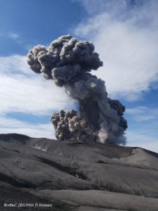
Kamchatka , Karymsky :
VOLCANO OBSERVATORY NOTICE FOR AVIATION (VONA)
Issued: July 15 , 2021
Volcano: Karymsky (CAVW #300130)
Current aviation colour code: ORANGE
Previous aviation colour code: orange
Source: KVERT
Notice Number: 2021-70
Volcano Location: N 54 deg 2 min E 159 deg 26 min
Area: Kamchatka, Russia
Summit Elevation: 1486 m (4874.08 ft)
Volcanic Activity Summary:
A moderate eruptive activity of the volcano continues. According to satellite data by KVERT, an ash plume is extending for 42 km to the southeast of the volcano.
A moderate eruptive activity of the volcano continues. Ash explosions up to 19,700-23,000 ft (6-7 km) a.s.l. could occur at any time. Ongoing activity could affect low-flying aircrafts.
Volcanic cloud height:
2000 m (6560 ft) AMSL Time and method of ash plume/cloud height determination: 20210715/0139Z – NPP (4m5)
Other volcanic cloud information:
Distance of ash plume/cloud of the volcano: 42 km (26 mi)
Direction of drift of ash plume/cloud of the volcano: ESE / azimuth 102 deg.
Source : Kvert.
Photo : RIA Novosti Alexandre Piragis
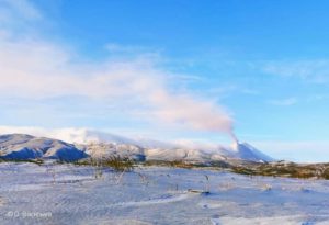
New Zealand , White Island :
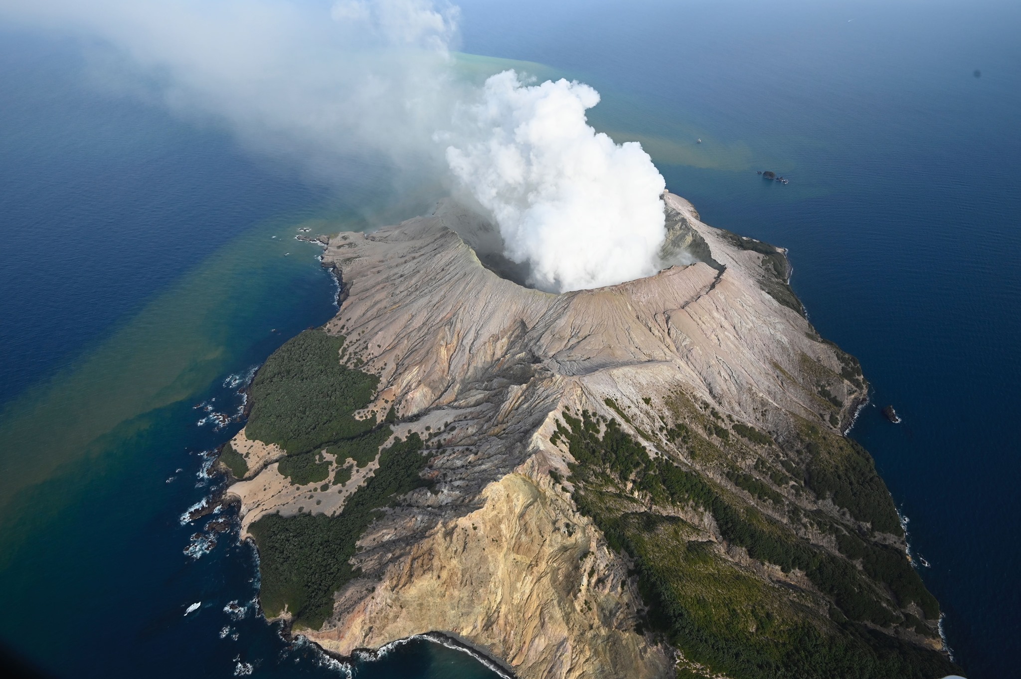
Interesting sights from Whakaari/White Island , Published: Fri Jul 16 2021 9:30 AM
Residents in the Bay of Plenty, and visitors to our volcano cameras page may have spotted some large plumes from Whakaari/White Island recently, as well as a strange glow on the night cameras. We take a look into the cause of these volcanic sights.
The cause of the large volcanic plume
With ideal weather conditions during the last couple of weeks, the residents of Bay of Plenty were able to view large steam and gas plumes from Whakaari/White Island. These were also visible via the web camera watching the volcano from Whakatane. The steam and gas plume originates from several active vents on the island and are clustered in and around the craters formed in December 2019.
Several factors contribute to how the steam and gas plumes appear above the volcano. These include heat flow, gas output, and the presence of ground water, lakelets or crater lakes. Humidity, dew point, air temperature and windspeed can also play a role. Line all of these up like we did over the last couple of weeks and you can have large spectacular steam and gas plumes over the volcano.
Gas is formed from subduction and magmatic processes at depth and is discharged at volcanoes and geothermal areas. The gas leaks from the rising geothermal fluids and molten rock (magma). Steam-water vapour (H2O) is the most common volcanic gas constituent. However, there are several other gas species present. After steam, in order of abundance they are carbon dioxide (CO2) sulphur dioxide (SO2) and hydrogen sulphide (H2S). GeoNet measures the amount of these present during regular gas flights.
What is the Night Glow?
Since 30 June we have seen a night glow return to the island, visible from our Crater Rim camera at night. Our Volcanic cameras have both daylight and low light cameras installed, allowing pictures to be taken at night when there is enough ambient light (such as from a full moon). The low light cameras are also able to see the hot steam and gas vents, and these appear as a ‘glow’ on our cameras on the island. This usually requires moderate-strong and hot emissions from the vents on the volcano for this to occur. Observations from a flight on 15 July confirmed temperatures of 500-600 °C are now present.
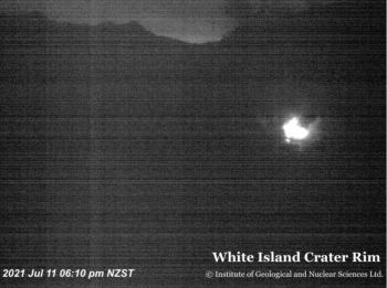
You can clearly see the night glow in the image below, with the daytime view for comparison. This ‘glow’ is only visible in the near infra-red with our webcam and unlikely to be visible with the naked eye.
Source et vidéo : Geonet
Photos : George Novak , Geonet.
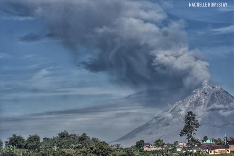
Indonesia , Sinabung :
Level of activity at level III (SIAGA) since May 20, 2019 at 10:00 a.m. WIB. The Sinabung volcano (2,460 m above sea level) has been erupting since 2013.
The volcano is clearly visible until it is covered in fog. No smoke from the crater was observed. The weather is sunny to cloudy, the wind is weak to moderate in the east and southeast.
According to the seismographs of July 15, 2021, it was recorded:
4 emissions earthquakes
31 hybrid / multi-phase earthquakes
VOLCANO OBSERVATORY NOTICE FOR AVIATION – VONA
Issued : July 13 , 2021
Volcano : Sinabung (261080)
Current Aviation Colour Code : ORANGE
Previous Aviation Colour Code : orange
Source : Sinabung Volcano Observatory
Notice Number : 2021SIN77
Volcano Location : N 03 deg 10 min 12 sec E 98 deg 23 min 31 sec
Area : North Sumatra, Indonesia
Summit Elevation : 7872 FT (2460 M)
Volcanic Activity Summary :
Eruption with ash clouds at 02h25 UTC (09h25 local time). The eruption lasted for 463 seconds.
Volcanic Cloud Height :
Best estimate of ash-cloud top is around 9472 FT (2960 M) above sea level, may be higher than what can be observed clearly. Source of height data: ground observer.
Other Volcanic Cloud Information :
Ash-cloud moving to E-SE.
Remarks :
Deep seismic activity is characterized by volcanic earthquake, Low Frequency Earthquake, and Hybrid Earthquake.
Source : PVMBG , Magma Indonésie .
Photo : Nachelle Homestay. (10/05)