July 08 , 2021.
Italy / Sicily , Etna :
Weekly Bulletin from July 28, 2021 to July 04, 21 (issue date July 06, 2021)
SUMMARY STATEMENT OF ACTIVITY
In view of the monitoring data, it is highlighted:
1) VOLCANOLOGICAL OBSERVATIONS: Strombolian activity, lava fountains and formation of eruptive columns at the Southeast Crater; occasional ash emission at the Northeast Crater; pulsed degassing with low ash emissions at the Bocca Nuova Crater; ordinary degassing at the Voragine Crater.
2) SEISMOLOGY: Weak seismic activity of fracturing, high values of tremor during lava fountains.
3) INFRASON: Low infrasound activity except for the eruptive events at the Southeast Crater.
4) DEFORMATIONS: During the last week, the inclinometric network recorded significant changes in correspondence with the events of lava fountains.
Analysis of the GNSS data acquired at high frequency did not show any significant changes.
5) GEOCHEMISTRY: The flow of SO2 at an average level, with high values during the eruptive phases. HCl flux: Data not available, the latest measurements are at an average level. The flux of CO2 from the soil decreases, the most recent values have gone from high to medium.
The partial pressure of dissolved CO2 does not show significant changes.
There are no updates for the C / S report.
The isotopic ratio of helium remains stable on average values (last update of 06/21/2021).
6) SATELLITE OBSERVATIONS: The thermal activity in the summit area was high to very high in correspondence with the lava fountains.

VOLCANOLOGICAL REMARKS
During the week, the monitoring of the volcanic activity of Etna was carried out by analyzing the images of the network of surveillance cameras of the INGV section of Catania, Osservatorio Etneo (INGV-OE), and by the staff of the INGV in the field.
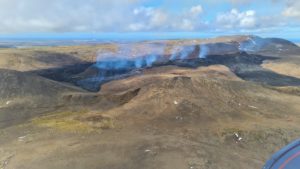
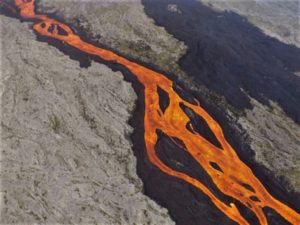
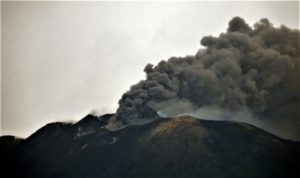
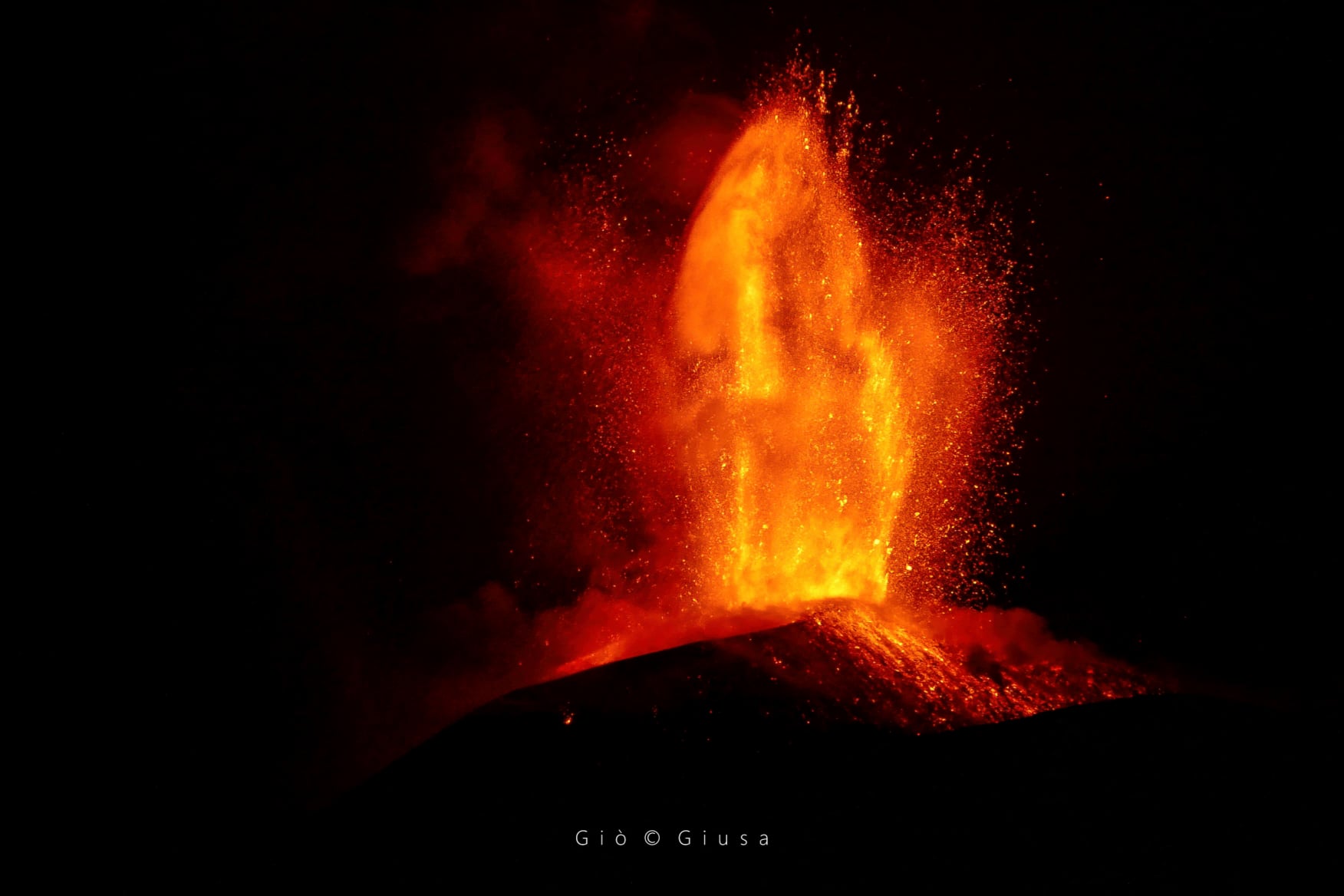
During the week, there were 3 episodes of lava fountains in the Southeast Crater (SEC), with the formation of eruptive columns, which reached varying heights from a minimum of 5 km to a maximum of 10 km above sea level. All lava fountains were mainly accompanied by lava overflows to the southwest (Fig. 1).
The fallout from products on the ground mainly affected the eastern and south-eastern sectors of the volcano. The episode of July 4 was characterized by the emission of pulsed ash which lasted approximately 2 hours after the end of the lava fountain.
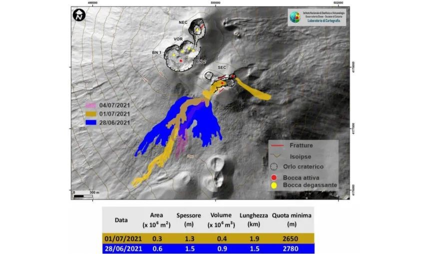
Map of Etna flows from June 28 to July 1 on a shaded model of the terrain. BN: Bocca Nuova, VOR: Voragine; NEC: northeast crater; SEC: south-eastern crater. The topographic reference base on which the morphological updates have been superimposed is the DEM 2014 developed by the Aerogeophysical Laboratory-Section Rome 2.
COMMUNICATION ON THE ACTIVITY OF ETNA 07 July 2021, 00:15 (22:15 UTC).
The National Institute of Geophysics and Volcanology, Osservatorio Etneo, reports that as of approximately 22:00 UTC, intense explosive activity is underway from the Southeast Crater. Based on the forecast model, the volcanic cloud dispersed to the southeast. The increase in the amplitude of the tremor continues, reaching high values. The frequency and amplitude of infrasonic events increase. Data from the inclinometric network show little variation at the Cratere del Piano station (ECP). GNSS network data does not show significant changes.
01:02 (23:02 UTC). From 22:30 UTC, we observe the gradual passage of Strombolian activity in the form of a lava fountain in the Southeast Crater. According to the forecast model, the eruptive cloud produced by the current activity disperses in a southerly direction, reaching a height of about 5000 m above sea level. Observations made by INGV personnel present in the field show an abundant fallout of coarse material that covers the flanks of the cone of the Southeast Crater up to the area of the old Torre del Filosofo. A relapse of Lapilli is reported in Tremestieri (south side).
COMMUNICATION ON THE ACTIVITY OF ETNA 07 July 2021, 02:19 (00:19 UTC).
The National Institute of Geophysics and Volcanology, Osservatorio Etneo, reports that the Southeast Crater lava fountain is complete, while weak Strombolian activity with ash emission continues. The eruptive activity produced a small lava flow from the southern flank of the cone of the Southeast Crater. The flow, which was heading towards the southwest, is currently fed and is located at an altitude of about 2800 m.
Reports have been received on the fallout of volcanic materials on the town of Nicolosi (south side).
The amplitude of the tremor decreases markedly, although still in the high range. The sources of the tremor are located in the area of the Southeast Crater at a level of 2800-3000 m s.l.m. Residual infrasound activity is noted. The stations in the inclinometric network recorded modest variations, with the exception of the Cratere del Piano (CPN) and Pizzi Deneri (PDN) stations, which showed variations of the order of 3 microradians and 1 microradians respectively. No significant change is observed in the signals acquired by the GNSS network.
23:29 (21:29 UTC):
From around 20:35 UTC, we observe the resumption of Strombolian activity at the Southeast Crater associated with a weak emission of ash which disperses in the summit area. For the moment (21:20 UTC) the amplitude of the tremor is stationary in the low range. The signal sources are located in the area of the central craters at a level between 2880 and 3000 m above sea level. The infrasound activity is low. The data from the inclinometric network and the GNSS network do not show any significant changes.
Further updates will be communicated shortly.
Source : INGV.
Photos : Guide Alpine Vulcanologiche Etna , Ingv , Gio Giusa.
Philippines , Taal :
TAAL VOLCANO BULLETIN 07 July 2021 8:00 AM
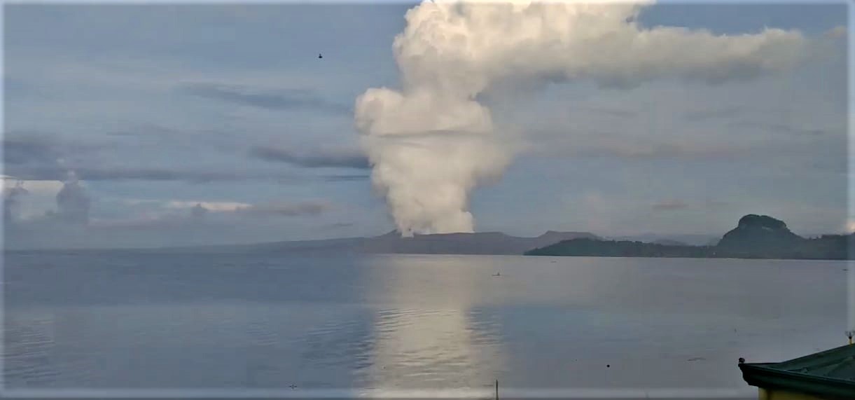
At 5:18 AM today, a short-lived phreatomagmatic eruption occurred at Main Crater and generated a grayish plume that rose 300 meters before drifting southeast.
In the past 24-hour period, the Taal Volcano Network recorded fifty-five (55) volcanic earthquakes, including one (1) explosion-type earthquake, forty-four (44) low frequency volcanic earthquakes, five (5) volcanic tremor events having durations of two (2) to five (5) minutes, five (5) hybrid earthquakes and low-level background tremor that has persisted since 08 April 2021. High levels of volcanic sulfur dioxide or SO2 gas emissions and steam-rich plumes that rose one thousand five hundred (1,500) meters before drifting southwest was generated from the Taal Main Crater. Sulfur dioxide (SO2) emission averaged 7,560 tonnes/day on 06 July 2021. Based on ground deformation parameters from electronic tilt, continuous GPS and InSAR monitoring, Taal Volcano Island has begun deflating in April 2021 while the Taal region continues to undergo very slow extension since 2020.
TAAL VOLCANO BULLETIN 08 July 2021 8:00 AM
A series of five (5) short phreatomagmatic bursts occurred at 08:47 AM, 09:15 AM, 09:26 AM, 11:56 AM, and 09:41 PM yesterday and produced short jetted plumes that rose up to 700 meters above the Main Crater Lake.
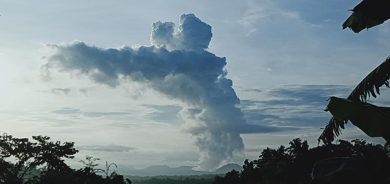
In the past 24-hour period, the Taal Volcano Network recorded sixty-one (60) volcanic earthquakes, including five (5) explosion-type earthquakes, twenty-four (24) low frequency volcanic earthquakes, twenty-one (21) volcanic tremor events having durations of two (2) to four (4) minutes, ten (10) hybrid earthquakes, and low-level background tremor that ended yesterday at 06:21 PM but resumed at 09:52 PM. High levels of volcanic sulfur dioxide or SO2 gas emissions and steam-rich plumes that rose one thousand five hundred (1,500) meters before drifting southwest was generated from the Taal Main Crater. Sulfur dioxide (SO2) emission averaged 11,397 tonnes/day on 07 July 2021.
Source : Phivolcs.
Photos : Stefan Wagner , JhuLia Mendoza
Kamchatka , Karymsky :
VOLCANO OBSERVATORY NOTICE FOR AVIATION (VONA)
Issued: July 08 , 2021
Volcano: Karymsky (CAVW #300130)
Current aviation colour code: ORANGE
Previous aviation colour code: orange
Source: KVERT
Notice Number: 2021-65
Volcano Location: N 54 deg 2 min E 159 deg 26 min
Area: Kamchatka, Russia
Summit Elevation: 1486 m (4874.08 ft)
Volcanic Activity Summary:
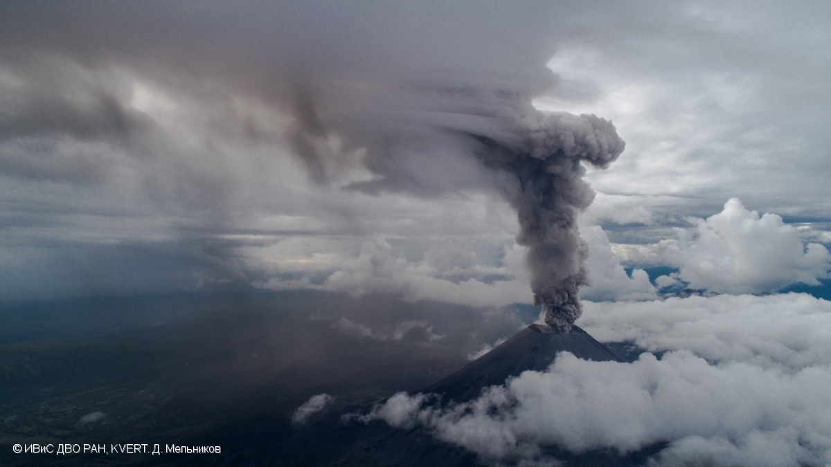
A moderate eruptive activity of the volcano continues. According to satellite data by KVERT, ash plume extended for 60 km to the west of the volcano.
This activity continues. Ash explosions up to 19,700-23,000 ft (6-7 km) a.s.l. could occur at any time. Ongoing activity could affect low-flying aircrafts.
Volcanic cloud height:
2500 m (8200 ft) AMSL Time and method of ash plume/cloud height determination: 20210708/0011Z – NOAA 18 (4m5)
Other volcanic cloud information:
Distance of ash plume/cloud of the volcano: 60 km (37 mi)
Direction of drift of ash plume/cloud of the volcano: W / azimuth 277 deg
Source : Kvert .
Photo : D. Melnikov, IVS FEB RAS, KVERT
Peru , Sabancaya :
Analysis period: June 28, 2021 to July 04, 2021, Arequipa, July 05, 2021.
Alert level: ORANGE
The Geophysical Institute of Peru (IGP) reports that the eruptive activity of the Sabancaya volcano remains at moderate levels, that is to say with the recording of an average of 91 daily explosions, with columns of ash and of gas up to an altitude of 3.0 km above the summit of the volcano and their consequent dispersion. Therefore, for the following days, no significant change is expected in eruptive activity.
The IGP recorded and analyzed the occurrence of 1,103 earthquakes of volcanic origin, associated with the circulation of magmatic fluids within the Sabancaya volcano. An average of 91 explosions was recorded daily. During this period, Volcano-Tectonic (VT) earthquakes associated with rock fractures were located mainly in the North-East and North-West of Sabancaya and presented magnitudes between M1.9 and M3.6.

The monitoring of the deformation of the volcanic structure using GNSS techniques (processed with fast orbits) does not present any significant anomalies. However, in general, an inflation process was observed in the northern sector (around the Hualca Hualca volcano). Visual surveillance made it possible to identify columns of gas and ash up to 3.0 km altitude above the summit of the volcano, which were scattered towards the southwest, south, west and northeast sectors of the volcano. Sabancaya. Satellite recordings identified the presence of 11 thermal anomalies (maximum value of 56 MW) associated with the presence of a lava body on the surface of the volcano’s crater.
RECOMMENDATIONS
• Keep the volcanic alert level in orange.
• Do not approach within a radius of 12 km from the crater.
Source : IGP.
Photo : ingemmet.
Italy , Stromboli :
Weekly Bulletin from July 28, 2021 to July 04, 21 (issue date July 06, 2021)
SUMMARY STATEMENT OF ACTIVITY
In view of the monitoring data, it is highlighted:
1) VOLCANOLOGICAL OBSERVATIONS: Normal explosive volcanic activity of Strombolian type accompanied by splashing activity sometimes intense in zone N2. The total frequency of events showed values between medium-low and medium-high levels (9-18 events / h).
The intensity of the explosions varied from low to medium in the North crater area and from low to high in the Center-South area.
2) SEISMOLOGY: The seismological parameters monitored do not show significant variations.
3) DEFORMATIONS: The island’s soil deformation monitoring networks did not show any significant changes during the period under review.
4) GEOCHEMISTRY: SO2 flux at an average level.
The average weekly value of the C / S ratio (4.5), updated on 07/04/2021, remains at average values.
The isotopic ratio of Helium dissolved in the thermal aquifer (sample from 06/21/2021) remains at average values.
5) SATELLITE OBSERVATIONS: The thermal activity in the summit area is moderate to low.
VOLCANOLOGICAL REMARKS
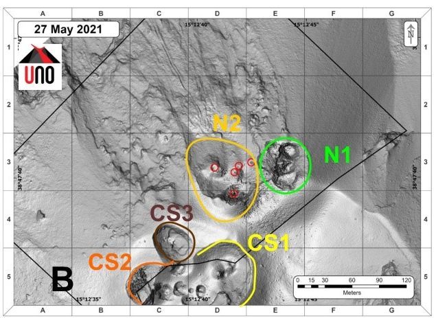
In the observation period, the eruptive activity of Stromboli was characterized by the analysis of the images recorded by the surveillance cameras INGV-OE located at 190 m, in Punta Corvi, at 400 m and on the Pizzo sopra la Fossa . The explosive activity was mainly produced by 3 (three) eruptive chimneys located in the North crater area and 4 (four) eruptive chimneys located in the Center-South crater area. All the vents are located inside the depression which occupies the terrace of the crater.
Description of the eruptive activity recorded by surveillance cameras.
In the area of the North crater, the N1 crater produced explosions of varying intensity, from low to medium-high (sometimes the products exceeded 150 m in height), emitting coarse materials (lapilli and bombs) sometimes mixed with materials fine (ash). The N2 vent, with two emission points, showed low intensity explosive activity (the products did not reach 80 m in height) emitting coarse materials with intense projection activity which was observed until June 28 . The average frequency of explosions varied from 4 to 10 events / h.
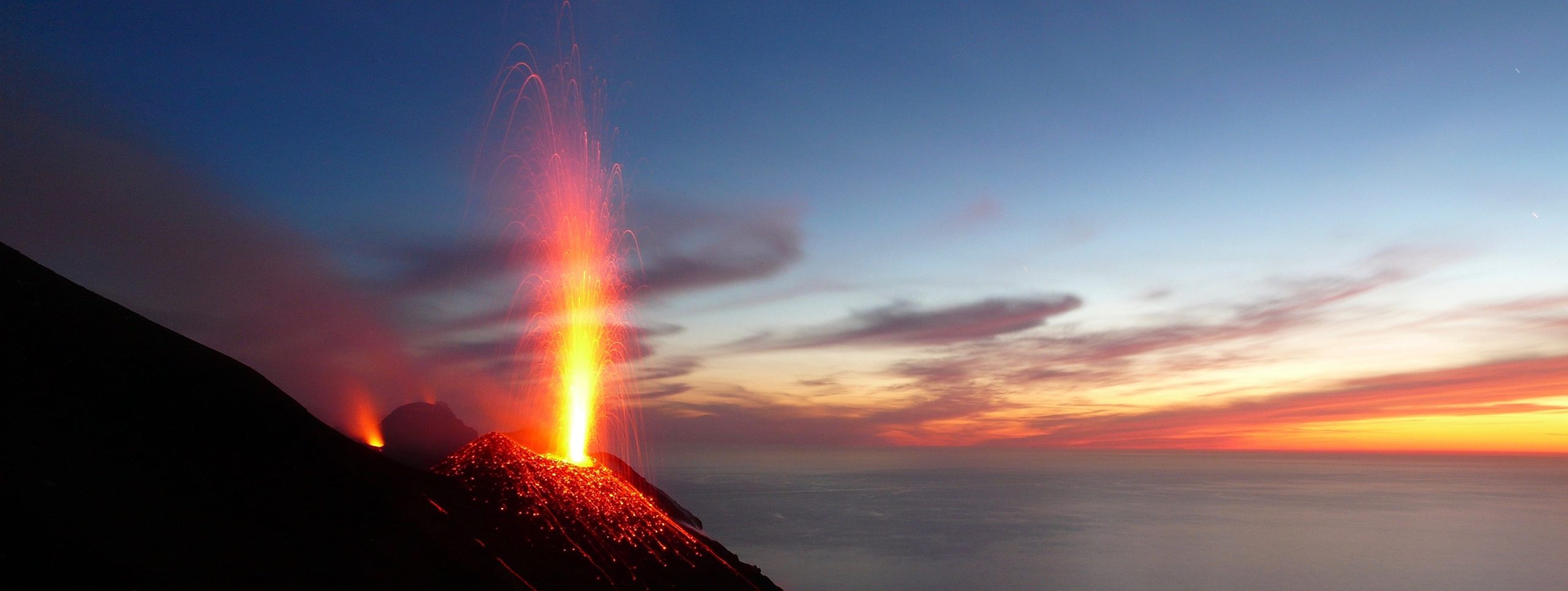
In the Center-South crater area, the dominant explosive activity was observed at the S2 vent, with two emission points that also produced simultaneous activity, with explosions emitting mostly coarse materials mixed with ash, with medium-high intensity (in many explosions the products exceeded 150 m in height). The explosive activity showed average hourly frequency values ranging from 5 to 8 events / h.
Source : INGV.
Photos : INGV , Stromboli Adventures.