June 02 , 2021.
Italy / Sicily , Etna :
Weekly bulletin from May 24, 2021 to May 30, 2021, (issue date June 01, 2021)
SUMMARY OF THE STATE OF ACTIVITY
In the light of surveillance data, it is highlighted:
1) VOLCANOLOGICAL OBSERVATIONS: Eruptive episodes at the Southeast Crater; degassing activity of other summit craters.
2) SEISMOLOGY: Weak seismic activity of fracturing; the amplitude of the tremor varied from medium-low levels to high levels recorded during paroxysmal events
3) INFRASOUND: High infrasound activity concomitantly with lava fountain episodes at the Southeast Crater, low in the remaining period.
4) DEFORMATIONS: The GNSS network showed a weak tendency for deflation during the week. The inclinometric network showed simultaneous variations with the lava fountain events.
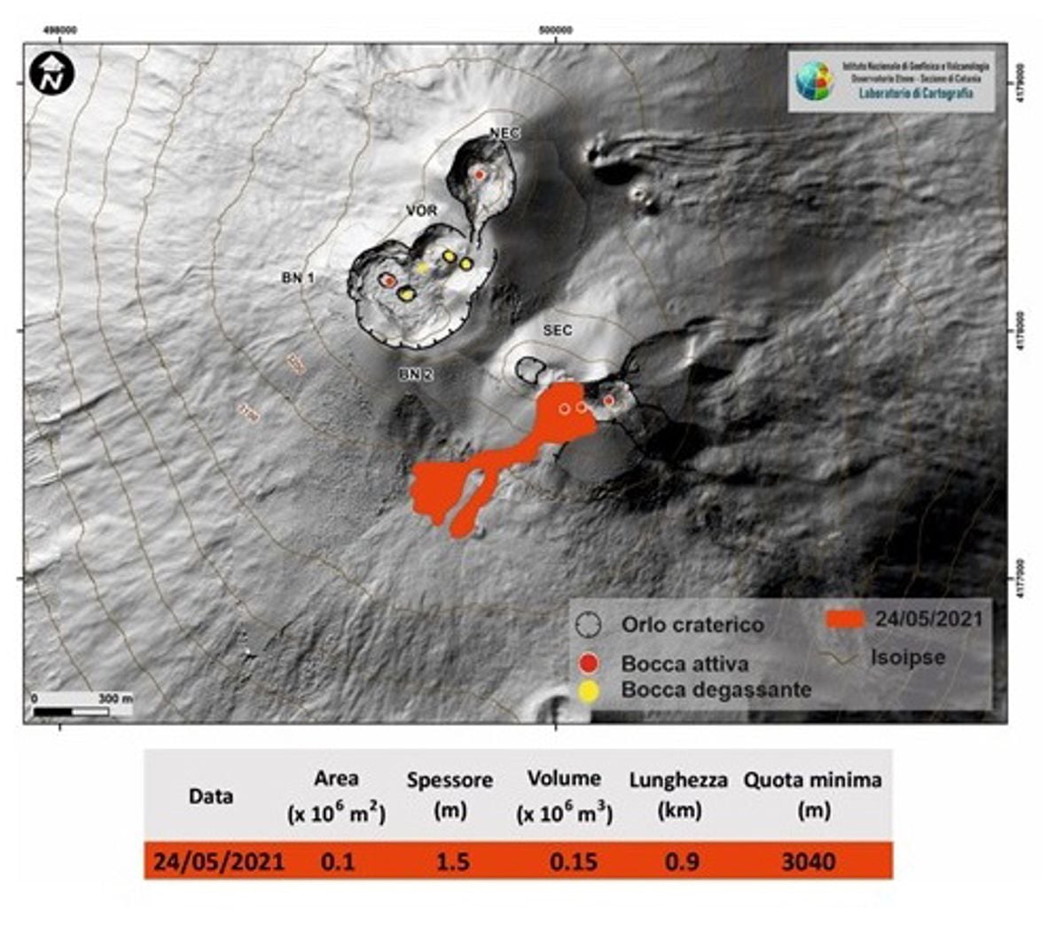
Map of the summit craters of Etna. BN: Bocca Nuova, VOR: Voragine; NEC: northeast crater; SEC: south-eastern crater. The topographic reference frame on which the morphological updates have been superimposed concerns the 2014 DEM developed by the Aerogeophysical Laboratory-Section Rome 2; map of the flow from 05/24/2021.
5) GEOCHEMISTRY: SO2 flux at an average level, with intra-daily values at a high level
The CO2 flux from the soil shows average values.
The partial pressure of dissolved CO2 in groundwater reaches background values.
No new data from the C / S ratio is available.
The helium isotope ratio shows a downward trend, remaining on average values (sampling of 05/14/2021).
6) SATELLITE OBSERVATIONS: The thermal activity in the summit area is high to very high level.
VOLCANOLOGICAL OBSERVATIONS
During the week, the monitoring of the volcanic activity of Etna was carried out by analyzing the images of the surveillance cameras of the INGV, Osservatorio Etneo (INGV-OE) and thanks to various inspections carried out by the staff of the INGV-OE, one of them (May 26) in the summit area.
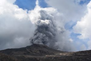
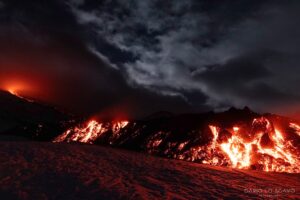
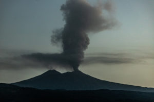
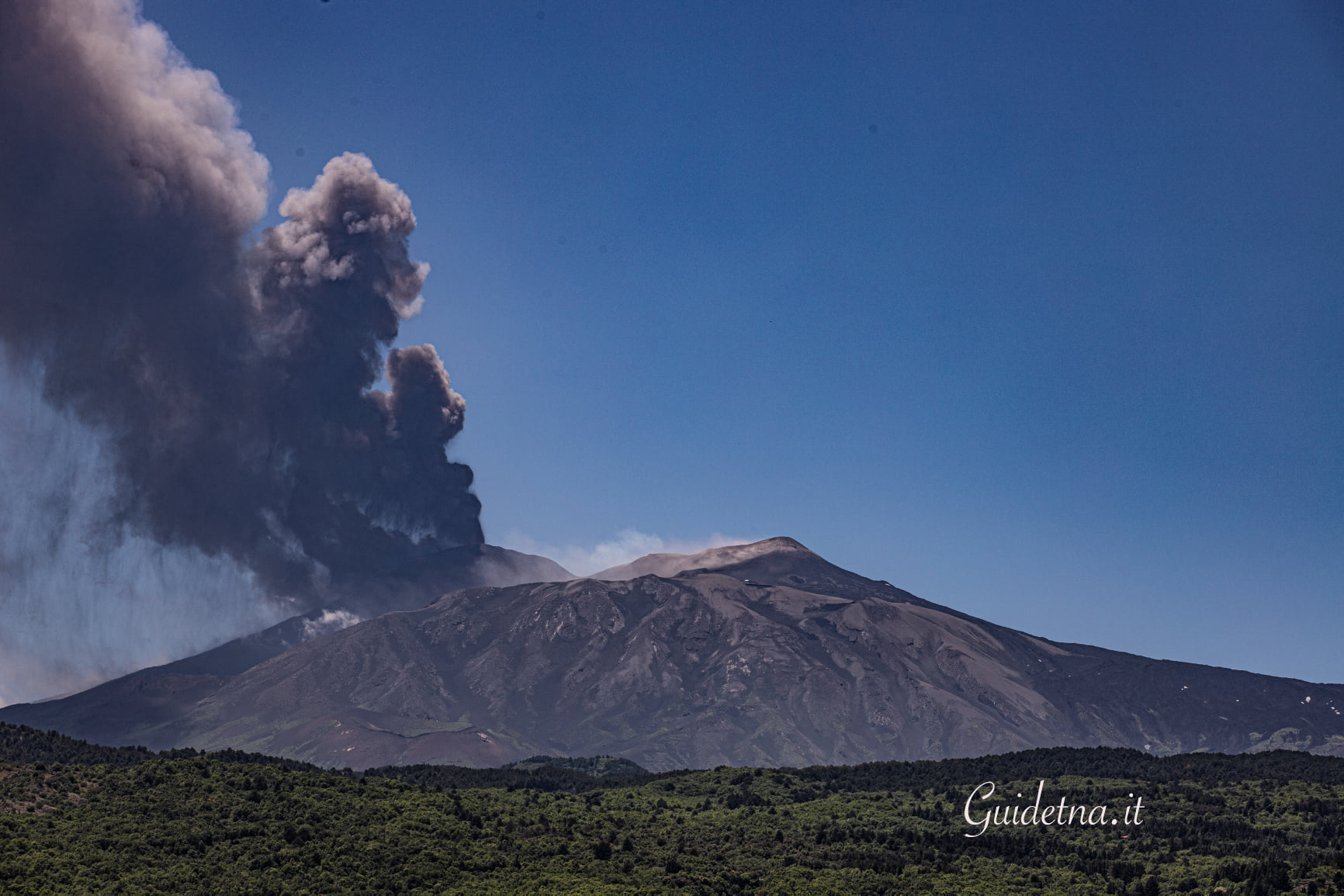
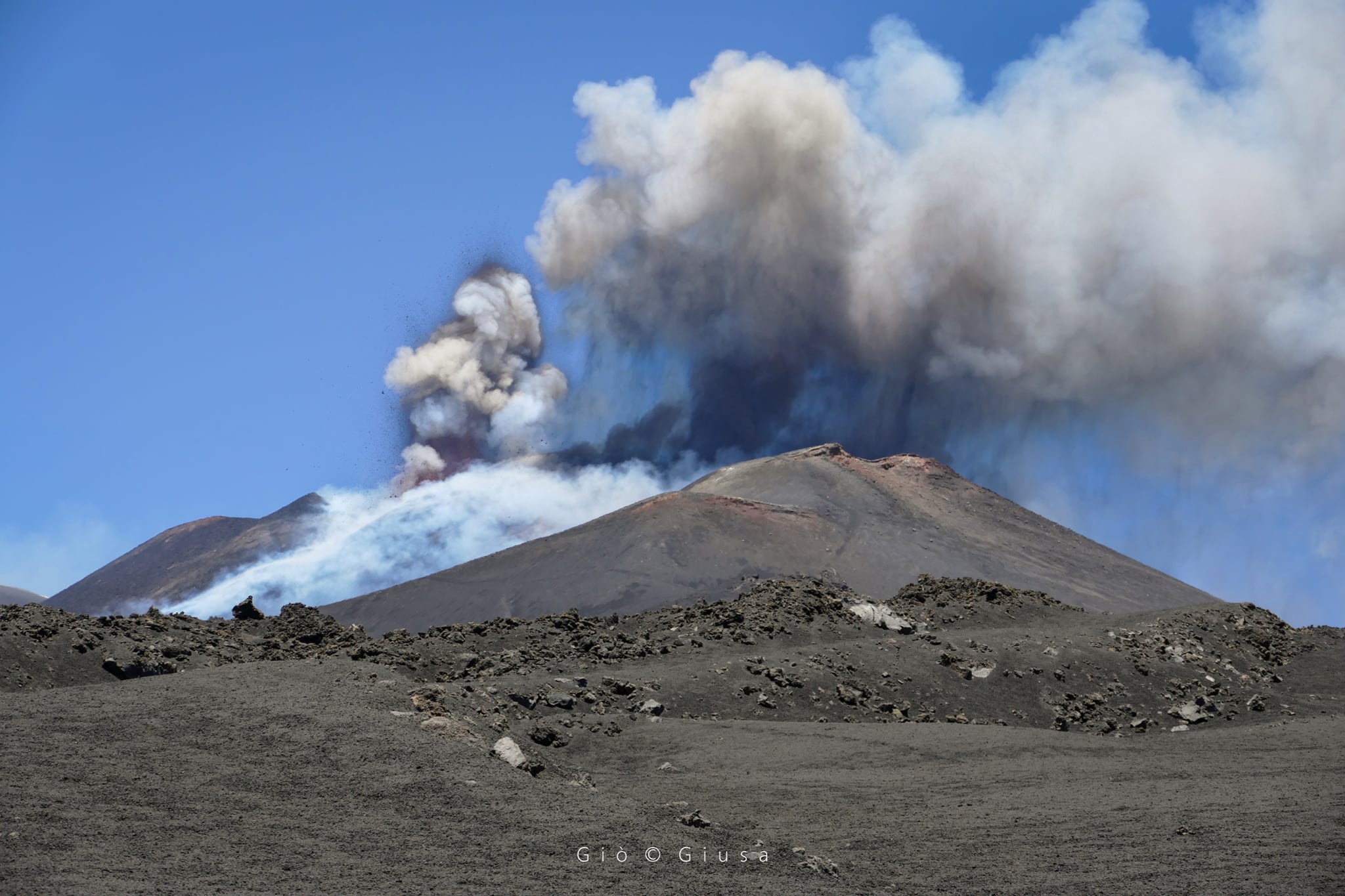
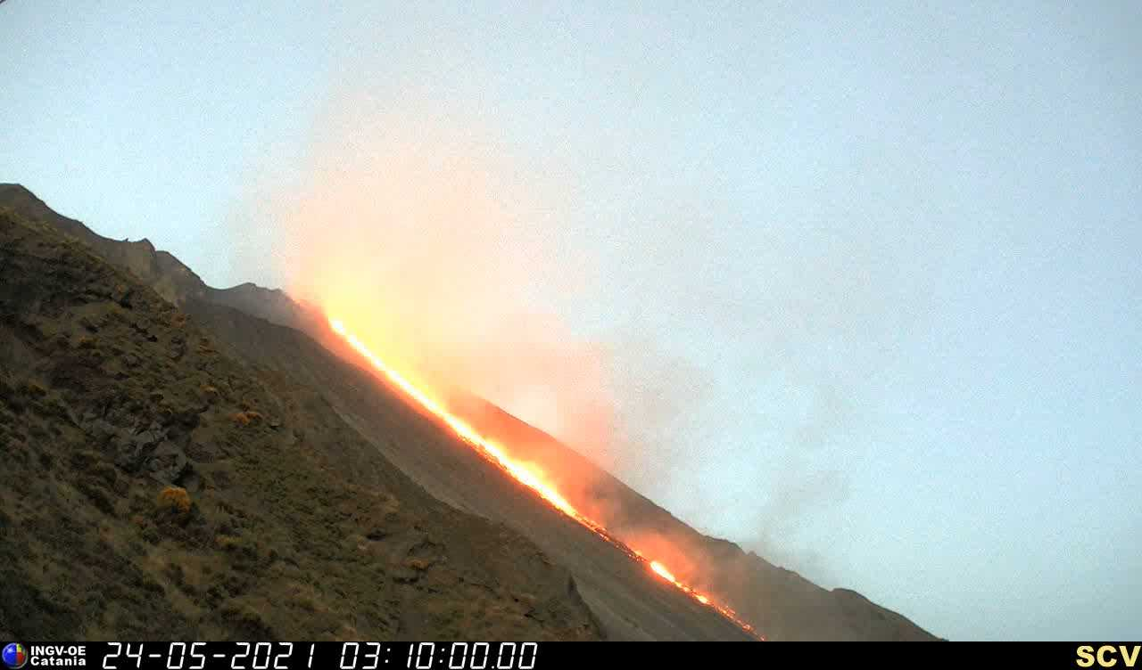
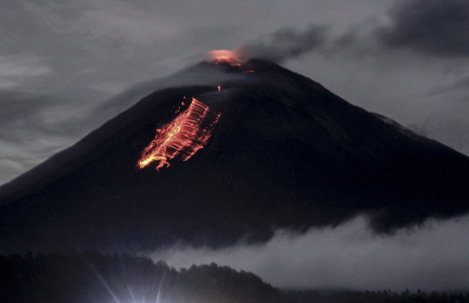
During the week, there were several eruptive episodes at the Southeast Crater (SEC), which occurred on May 24, 25, 26, 27, 28 and 30, respectively. Most of these events consisted of the resumption of Strombolian activity at the Southeast Crater (SEC) followed by a gradual intensification of the eruptive phenomenon until, in some cases, the stage of a sustained lava fountain. This activity was also accompanied by lava overflows heading southwest, always remaining in the summit area. Due to adverse weather conditions, there is insufficient data to perform a correct flow mapping. Finally, degassing activity was observed at the level of the other summit craters.
The first eruptive episode of the week from the Southeast Crater (SEC) occurred on May 24 from 19:00 UTC. The most intense phase was reached between 20:35 UTC and 21:45 UTC.
The activity ended around 10:10 a.m. UTC. On the morning of May 25, around 08:20 UTC, ash was observed near the Southeast Crater (SEC). This activity formed a light eruptive cloud about 4000 m high, dispersed towards the East-North-East. Explosive activity resumed in the afternoon at around 4:20 p.m. UTC and it was only after half an hour that an increase in Strombolian activity at the Southeast Crater (SEC) was recorded. The most intense phase took place between 18:25 and 19:00 UTC. The activity ended around 8:15 p.m. UTC.
Two more eruptive episodes occurred on May 26 and reached the phase of greatest intensity at around 1:50 a.m. and 11:00 a.m. UTC, respectively. On May 27, the Southeast Crater (SEC) was the
protagonist of a new eruptive episode, which intensified around 12:50 UTC. Due to bad weather conditions, it was not possible to observe the eruptive phenomenon from the INGV-OE surveillance cameras. During this event, a fall of pyroclastic material was reported in Giarre, Milo and Fornazzo. Three other eruptive episodes occurred on May 28, in the morning, late afternoon and evening. During the morning, the activity, which started around 06:30 UTC, peaked at around 07:00 UTC and then ended at 07:30 UTC. For this event, a fall of volcanic ash in Giarre was reported by INGV-OE personnel in the field. This activity anticipated two other very close episodes, the first, very mild and short, started at 3:40 p.m. UTC and was already finished by 4:15 p.m., the second, more powerful, started around 7:15 p.m. UTC and finished at 9:05 p.m. UTC. Finally, the last episode of the week of May 30, which started around 3:45 a.m. UTC, lasted about two hours.
The information on the height of the eruptive cloud was obtained from the analysis of data, when available, satellite images and the ECV calibrated camera.
The maximum height measured during all of these events is 7000 m above sea level. In general, the deposits consist mainly of fine material. Taking into account all the eruptive episodes, the sector of the volcano most affected by the fallout of ash and lapilli was that of the east. Finally, most of these episodes produced lava overflows that spread southwest along the sides of the Southeast Crater. During the same inspection, the INGV-OE confirmed the absence of eruptive activity at Voragine, Bocca Nuova and at the Northeast Crater.
Source : INGV
Photos : Guide Alpine Vulcanologiche Etna ( 26 /05) , Gio Giusa ( 26 /05) .
United States , Yellowstone :
44°25’48 » N 110°40’12 » W,
Summit Elevation 9203 ft (2805 m)
Current Volcano Alert Level: NORMAL
Current Aviation Color Code: GREEN
Recent work and news
In the past month there were two major water eruptions of Steamboat Geyser, on May 5 and 31. This brings the total number of eruptions for the year to 12.
During the month of May, Yellowstone Volcano Observatory scientists installed 15 semi-permanent GPS stations in and around Yellowstone National Park. These stations are deployed every spring and recovered in the fall, operating during the period of largely snow-free conditions, and they serve to augment the network of continuous GPS stations, which operate year-round. Scientists also performed maintenance on the temperature monitoring network at Norris Geyser Basin, replacing batteries and damaged equipment as needed. June will see additional work, including the deployment of nodal seismic stations in the Norris Geyser Basin, especially in the area of Steamboat Geyser and Cistern Spring. The goal of the seismic experiment is to better image the hydrothermal plumbing system that feeds individual thermal features at Norris Geyser Basin.
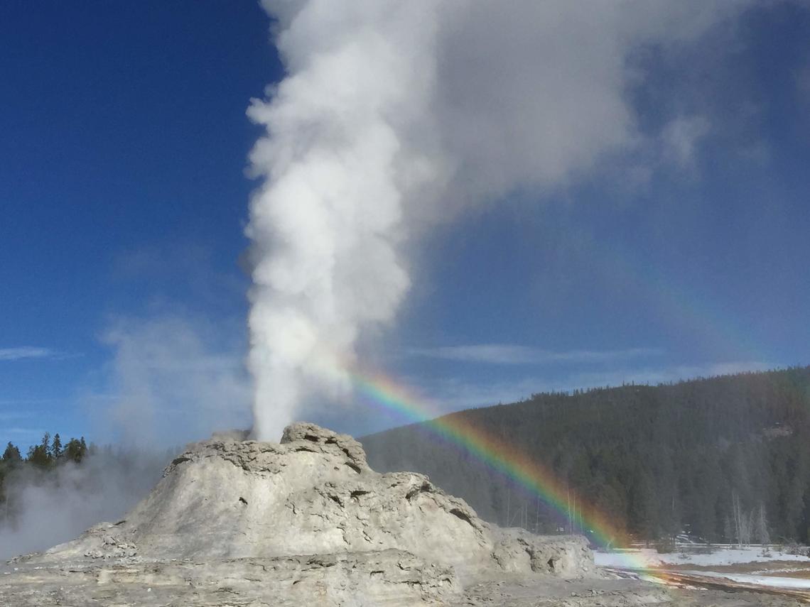
View of Castle Geyser, near Old Faithful, in eruption, taken from the boardwalk, November 5, 2019.
Seismicity
During May 2021, the University of Utah Seismograph Stations, responsible for the operation and analysis of the Yellowstone Seismic Network, located 72 earthquakes in the Yellowstone National Park region. The largest event was a microearthquake of magnitude 2.5 located 7 miles south of West Thumb, Yellowstone National Park, on May 23 at 5:53 AM MDT.
No swarm activity was observed in April.
Yellowstone earthquake activity remains at background levels.
Ground deformation
Deformation rates and styles at Yellowstone, as recorded by continuous GPS stations, have been steady over the past year. Subsidence of Yellowstone Caldera, which has been ongoing since 2015, continued at an average rate of 2–3 cm (about 1 in) per year. In the area of Norris Geyser Basin, no significant uplift or subsidence has been detected by a nearby GPS station since the start of 2020.
Source : YVO.
Photo : Shaul Hurwitz /USGS .
Saint Vincent , Soufrière Saint Vincent :
La Soufriere Volcano – SCIENTIFIC UPDATE 31/05/21 6:00PM
– Seismic activity at La Soufrière, St Vincent has remained low since the tremor associated with the explosion and ash venting on 22 April.
– From 5:40am on 30 May to 8:00am (local time) on 31 May, there has been no recorded seismicity associated with La Soufrière.
– Persistent steaming is observable from the observatory once the cloud cover is high enough.
– Thermal anomalies continue to be detected by the NASA FIRMS alert system.

This image taken on 29May shows the new look of La Soufriere, Saint Vincent from the Leeward (western) side. Professor Robertson has labelled the photo so we can notice the 1812 crater with tis lake, the 1979 crater rim, the 2021 explosion crater and the lowest point along the rim: the Larakai Gap. One can note that a lake is still present in the same location prior to this eruption. The alert is still at Orange and access to the volcano is still prohibited at this time.
– Thermal anomalies do not indicate an explosive event is imminent but that there is a source of heat, most likely from a small body of magma left over, close to the floor of the Summit Crater.
– The volcano continues to be in a state of unrest. Escalation in activity can still take place with little or no warning.
– The volcano is at alert level ORANGE
Source : UWI.
Photo : Francesco Gomez & Sandra Montabard, Martinique.
Italy , Stromboli :
Weekly bulletin from May 24, 2021 to May 30, 2021, (issue date June 01, 2021)
SUMMARY OF THE STATE OF ACTIVITY
In the light of surveillance data, it is highlighted:
1) VOLCANOLOGICAL OBSERVATIONS: Ordinary explosive volcanic activity of Strombolian type accompanied by splashing activity sometimes intense in zone N2. The total frequency of events showed values ranging from medium-low to medium (8-14 events / h). The intensity of the explosions varied from low to medium in the North crater area and medium-high in the Center-South area.
2) SEISMOLOGY: The seismological parameters monitored do not show significant changes, except for the increase in the amplitude of the tremor on May 24-25.
3) DEFORMATIONS: A weak transient deformation is noted in the inclinometric signal of Timpone del Fuoco in the morning of Saturday, May 29, 2021.
4) GEOCHEMISTRY: SO2 flux at an average level
The C / S ratio in the plume is at average values.
The isotopic ratio of He dissolved in the thermal aquifer remains at an average level.
5) SATELLITE OBSERVATIONS: The thermal activity in the summit area is moderate to low.
VOLCANOLOGICAL OBSERVATIONS
In the observation period, the eruptive activity of Stromboli was characterized by analyzing the images recorded by the surveillance cameras INGV-OE located at an altitude of 190 m, in Punta Corvi and at an altitude of 400 m.
Ground observations made on May 26 by INGV staff confirmed the absence of power to the flow observed by satellite already on May 24. In addition, observations indicated the presence at crater N2 of at least 6 active vents characterized by splashing, at least 4 of which are aligned and simultaneously produce eruptive activity. In addition, it was observed that the slag cone which occupied the central zone of the Center-North zone until May 16 is partially destroyed and without explosive activity. Behind him was formed a great depression. Finally, during the inspection of Pizzo on May 26, no product associated with the collapse of May 19 was found.
The splash activity at the mouth of the N2 crater was almost completely absent or very modest on May 27, when ash emissions and gas jets resumed in both the North area and the Center-South area. from the crater.
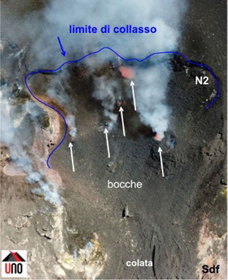
N2 crater area, white arrows indicate active vents, blue line the collapse limit, SdF = Sciara del Fuoco.
As part of the activities of the UNO / INGV-DPC Project, a DSM of the North area of the crater terrace was developed through the analysis of data collected on May 27, in order to estimate by subtraction with the DSM of 7 May, the volume of material involved in the event on May 19. The results of the analyzes indicated that the collapse involved both the area of the northern crater and the upper part of the nearby Sciara del Fuoco. The thickness of the lost material varies between 22 and 2 m while the material accumulated under the crater terrace has on the contrary a variable thickness between 2 and 12 m. There is a significant increase of 12 meters in the southern sector of the N2 crater from May 7 which highlights an increase in Strombolian activity in the period preceding the landslide.
Overall, the volume of material involved in the collapse, expressed as lost volume, amounts to 79,000 ± 7,000 m3. However, part of the collapsed area has already been filled in by flow and splash activity and, as mentioned above, crater N2 was likely larger than the May 7 relief. It follows that the missing volume must necessarily be greater. The volume accumulated in the investigated sector is equal to 13,600 ± 4,500 m3. The threshold value for detectable height differences is ± 0.5 m.
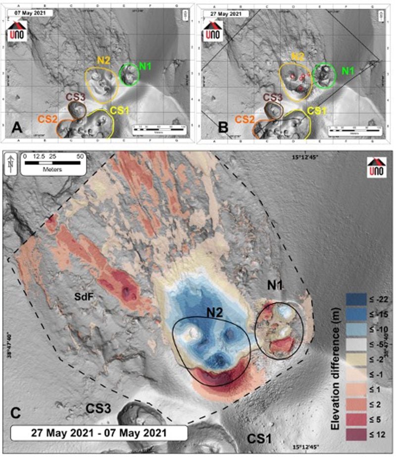
Shaded diagram of the crater area of May 7 and 27, 2021, respectively (A and B); in (C) difference expressed in m between the DSM of 27 and 07 May 2021, the color scale from red to blue indicates the thicknesses in m of the accumulated material and the lost material respectively. The lines of different colors delimit the areas of the crater, in (B) the red circles indicate the active mouths and SdF = Sciara del Fuoco.
In the area of the North crater, the N1 crater, with two emission points, produced explosions of varying intensity from low to medium (sometimes the products reached 150 m in height) emitting coarse materials (lapilli and bombs) . The N2 mouthpiece, with four emission points, showed explosive activity of varying intensity from low to medium-high (sometimes the products reached 250 m in height) emitting mainly coarse material with splash activity that was intense for short intervals. The average frequency of explosions varied from 6 to 13 events / h.
In the Center-South zone at least two emission points were detected with explosions emitting mainly fine materials with medium and sometimes high intensity (the products exceeded 250 m in height). The explosive activity showed average hourly frequency values between less than 1 and 4 events / h.
Source : INGV.
Photos : INGV.
Indonesia , Semeru :
VOLCANO OBSERVATORY NOTICE FOR AVIATION – VONA.
Issued : June 01 , 2021
Volcano : Semeru (263300)
Current Aviation Colour Code : ORANGE
Previous Aviation Colour Code : orange
Source : Semeru Volcano Observatory
Notice Number : 2021SMR31
Volcano Location : S 08 deg 06 min 29 sec E 112 deg 55 min 12 sec
Area : East java, Indonesia
Summit Elevation : 11763 FT (3676 M)
Volcanic Activity Summary :
Eruption with volcanic ash cloud at 23h16 UTC (06h16 local). Eruption and ash emission is continuing
Volcanic Cloud Height :
Best estimate of ash-cloud top is around 13683 FT (4276 M) above sea level, may be higher than what can be observed clearly. Source of height data: ground observer.
Other Volcanic Cloud Information :
Ash-cloud moving to southeast
Source : Magma Indonésie .
Photo : Umarul Faruq