April 25 , 2021.
Indonesia , Merapi :
Mount Merapi Activity Report, April 16-22, 2021
I. OBSERVATION RESULTS
Visual
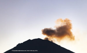
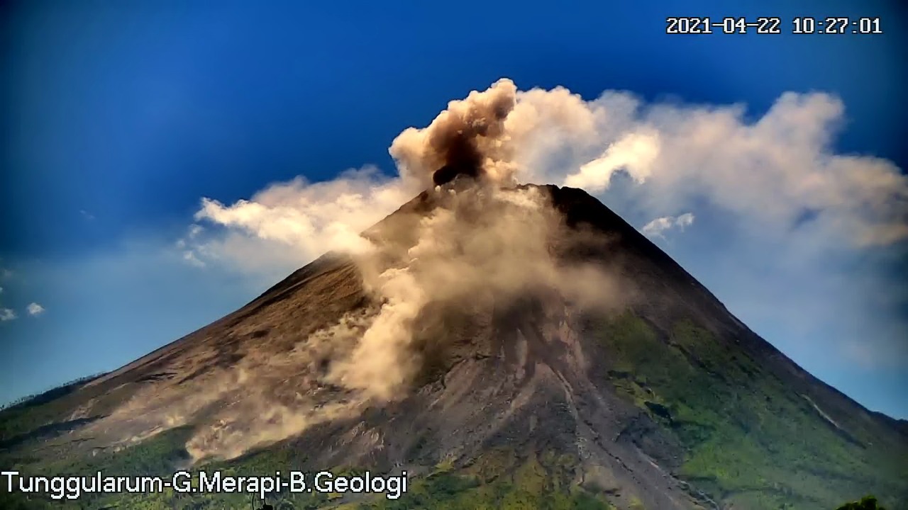
The weather around Mount Merapi is generally sunny in the morning and at night, while the afternoon until evening is foggy. There is white smoke, thin to thick with low pressure. A maximum smoke height of 250 m is observed from the Mount Merapi observation post in Jrakah on April 18, 2021 at 5:40 a.m. WIB.
Hot cloud avalanches occurred 9 times with an observed sliding distance of 1,800 m to the southwest and recorded on a seismogram with a maximum amplitude of 60 mm and a duration of 138 seconds. Lava avalanches were observed 144 times with a maximum slide distance of 1600 meters to the southwest and twice to the southeast with a slide distance of 400 m.
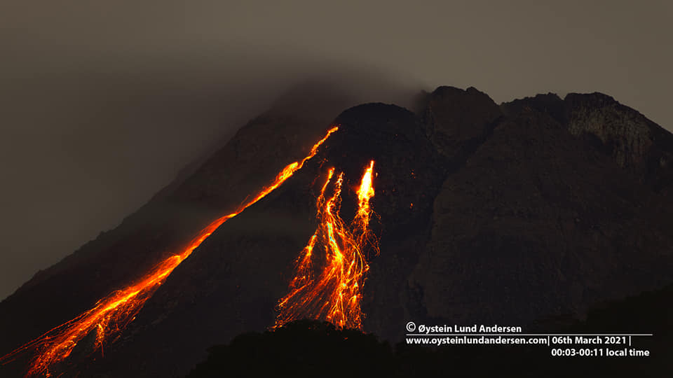
Morphological analysis of the summit area, based on photos of the southwest sector from April 15 to April 21, 2021 showed a change in the morphology of the area due to the excretion activity and the growth of the dome. The volume of the lava dome in the southwest sector is 1,069,600 m3 with a growth rate of 11,900 m3 / day. Morphological analysis based on photos of the Southeast sector from April 14 to April 22, 2021 shows the volume of the central dome of 1,794,000 m3.
Seismicity
This week, the seismicity of Mount Merapi recorded:
9 hot cloud avalanches (AP),
12 shallow volcanic earthquakes (VTB),
156 multi-phase earthquakes (MP),
924 avalanche earthquakes (RF),
14 emission earthquakes (DG)
4 tectonic earthquakes (TT).
The seismic intensity this week is higher than last week.
Deformation
The deformation of Mount Merapi which was monitored using EDM and GPS this week showed no significant changes.
Rain and lahars
This week there was rain at the Mount Merapi observation post with the highest rainfall intensity of 24mm / hour for 35 minutes at Ngepos post on April 18, 2021. There was no rain. lahars or additional flows in the rivers that descend from Mount Merapi.
Conclusion
Based on the results of visual and instrumental observations, it is concluded that:
The volcanic activity of Mount Merapi is still quite high in the form of effusive eruption activity. The activity status is defined at the « SIAGA » level.
Source : BPPTKG.
Photos : Oystein Lund Andersen , BPPTKG.
Alaska , Semisopochnoi :
51°55’44 » N 179°35’52 » E,
Summit Elevation 2625 ft (800 m)
Current Volcano Alert Level: WATCH
Current Aviation Color Code: ORANGE
Eruptive activity continues at Semisopochnoi volcano. Satellite views of the summit were mostly obscured by high-level clouds, but occasional clear views showed possible minor ash emissions. This eruptive activity was observed in a regional infrasound array. Small eruptions producing minor ash deposits within the vicinity of the volcano and ash clouds under 10,000 ft above sea level are typical of activity at this volcano.
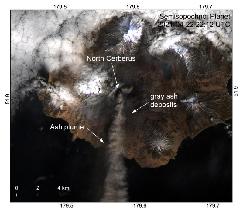
An ash plume extends from the north crater of Mount Cerberus to the south in a Planet image from April 22, 2021. Gray ash deposits are visible on the island, particularly on the south flank of Mount Cerberus, from frequent ash emissions over the past week.
Semisopochnoi is monitored by satellite data, regional infrasound, and lightning detection instruments. An infrasound array on Adak Island may detect explosive emissions from Semisopochnoi with a slight delay (approximately 13 minutes) if atmospheric conditions permit.
Source : AVO.
Photo : Dietterich, Hannah.
La Réunion Island , Piton de la Fournaise :
Press release of April 24, 2021 – 1:30 p.m.
The eruption that started on 04/09/2021 at 7 p.m. (appearance of the tremor) continues. The intensity of the volcanic tremor (indicator of a surface lava emission) over the last 24 hours has remained relatively stable and comparable to that observed the previous days.
– No direct observation of the eruptive site could be made today given the very bad weather conditions on the volcano.
– Over the last 24 hours, 8 superficial volcano-tectonic earthquakes (between sea level and the surface) have been recorded under the summit craters.
– CO2 fluxes in the soil are still increasing both in the far field (Plaine des Cafres and Plaine des Palmistes) and in the near field (Gîte du volcan).

– Averaged over the past few days, no significant trend can be seen in the deformations of the building (neither in deflation nor in inflation). It could suggest a flow of magma
deep entering the superficial magmatic reservoir equivalent to the outlet flow of the reservoir which feeds the eruptive site.
– The SO2 fluxes measured by the DOAS « NOVAC » network make it possible to estimate lava flows. Considering a partially degassed magma during the first days of the eruption, the maximum lava flow probably did not exceed 20 m3 / sec on April 9 and 10; the proportions of less degassed magma then probably increased over time, making it possible to estimate an average flow rate of around 24 m3 / sec for the day of 03/13 (with peaks of up to 59 m3 / sec). Since a lower average flow, between 1.2 and 8.3 m3 / sec, is estimated for the period from 16 to 23/04. It should be noted that bad weather conditions can affect the accuracy of the measurements.
– The surface flows estimated from satellite data via the HOTVOLC platform (OPGC – Clermont Auvergne University) could not be estimated with precision in recent days given the bad weather conditions on the eruptive site.
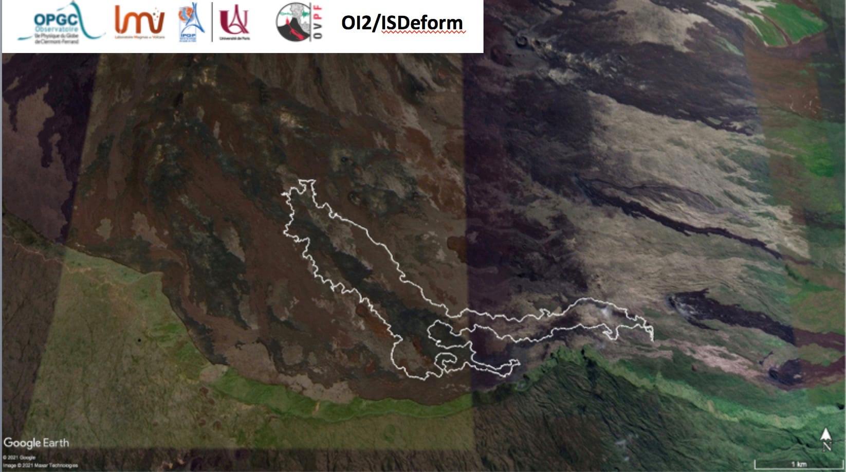
Trace of the lava flow dated April 23, 2021 evening deduced from satellite data (INSAR consistency data) (© LMV-OPGC-OVPF-IPGP-OI2 / ISDeform).
Satellite data made it possible to trace the precise outline of the lava flow on 04/23/2021. This card confirms that:. the flow front remains frozen in the Grandes Pentes about a hundred meters upstream from the Bonnet crater, and that the lava field now extends laterally, and by thickening at the level of the network of lava tunnels which has developed in place on the plate downstream of the cones.
The total length of the flow was still in the order of 3.5 km.
Source : OVPF.
Read the article : https://www.ipgp.fr/sites/default/files/ovpf_20210424_13h15_communique_eruption_1.pdf
Photos : Vincent Tunneldelave Réunion ( Vincent Cheville / https://rando-volcan.com ) , OVPF.
Indonesia , Semeru :
VOLCANO OBSERVATORY NOTICE FOR AVIATION – VONA .
Issued : April 24 , 2021
Volcano : Semeru (263300)
Current Aviation Colour Code : ORANGE
Previous Aviation Colour Code : orange
Source : Semeru Volcano Observatory
Notice Number : 2021SMR15
Volcano Location : S 08 deg 06 min 29 sec E 112 deg 55 min 12 sec
Area : East java, Indonesia
Summit Elevation : 11763 FT (3676 M)
Volcanic Activity Summary :
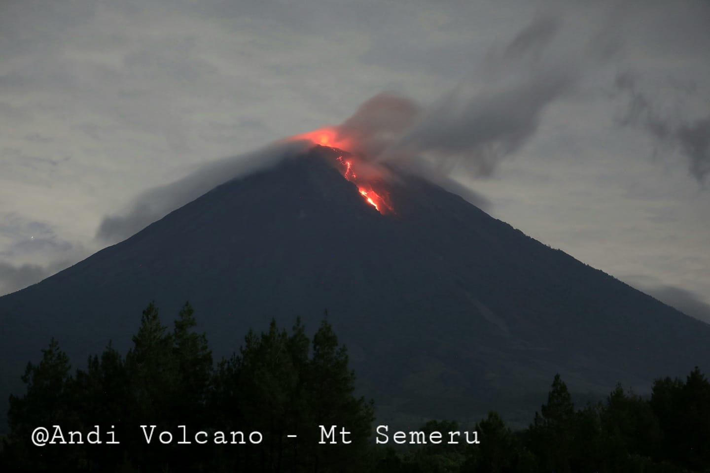
Eruption with volcanic ash cloud at 23h22 UTC (06h22 local). Eruption and ash emission is continuing.
Volcanic Cloud Height :
Best estimate of ash-cloud top is around 13363 FT (4176 M) above sea level, may be higher than what can be observed clearly. Source of height data: ground observer.
Other Volcanic Cloud Information :
Ash-cloud moving to southeast.
Level of activity at level II (WASPADA). The Semeru volcano (3676 m above sea level) is continuously erupting. Explosive and effusive eruptions are recorded, leading to lava flows towards the southern and south-eastern slopes, as well as explosions of incandescent rocks around the summit crater.
The volcano was clearly visible until it was covered in fog. Smoke from the crater was not observed. The weather is sunny to cloudy, the winds weak to the north, northeast and east.
According to the seismographs of April 24, 2021, it was recorded:
44 eruption / explosion earthquakes
8 emission earthquake
1 Harmonic tremor
1 distant tectonic earthquake
Source : Magma Indonésie , PVMBG.
Photo : Andi volcanist.