October 09 , 2021.
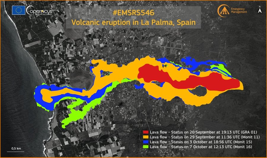
Spain / La Palma , Cumbre Vieja :
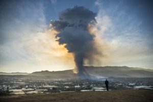
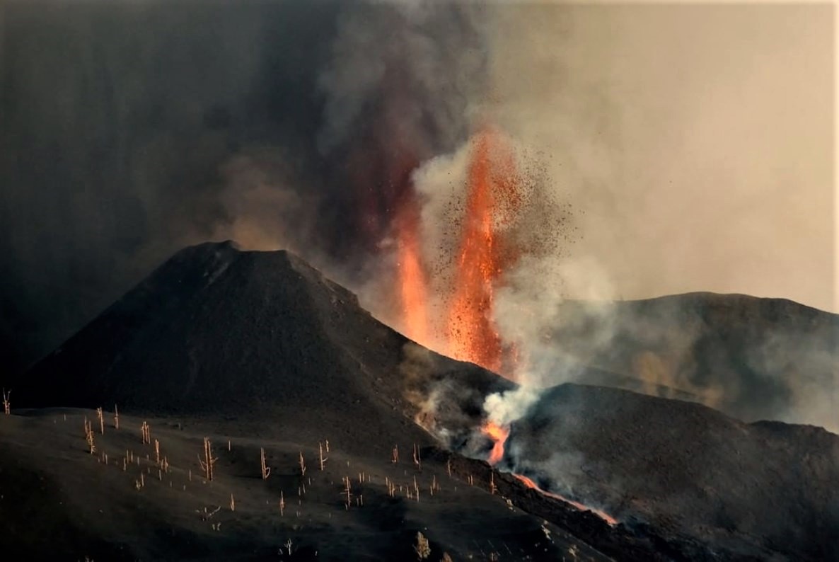
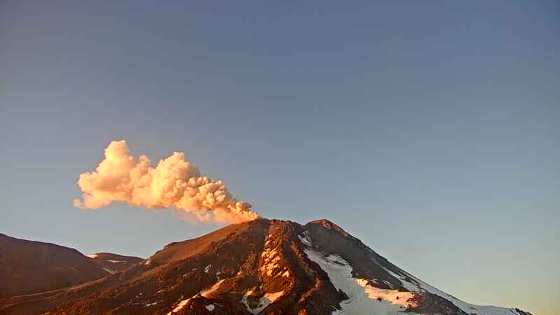
08 October 2021, 14:00 UTC, Eruptive activity continues on La Palma.
Since the last declaration, 180 earthquakes have been located in the area affected by the volcanic reactivation of Cumbre Vieja, 56 of these earthquakes were felt by the population, the maximum intensity being in the epicentral zone III-IV ( EMS98), with an earthquake that occurred at 22:42 UTC on the 6th, with a magnitude of 3.9 (mbLg) at a depth of 13 km.
The largest localized earthquake occurred yesterday at 11:17 am, with a value of 4.3 mbLg at a depth of 35 km. 14 of the earthquakes located since the last report are at depths greater than 30 km, the rest of the hypocenters are located at a shallower depth, around 10 km.
The average amplitude of the volcanic tremor remains stable within a range of average values compared to the observations measured during this eruption. No intensification pulse has been recorded since the last report.
The height of the eruptive column measured at 7:30 UTC is 2200 m and the scattering cloud is about 3500 m to the east.
The lava delta could collapse and generate gas, explosions and waves
Experts warned on Friday that if the advance of lava to greater depths continues into the sea, a collapse of the delta front generated by the volcanic eruption could occur that would be accompanied by a sudden release of gas. , with hydro-magmatic explosions and waves. The director of the National Geographical Institute of the Canaries, Maria José Blanco, indicated at a press conference this Friday that this situation could occur because « the platform has reached the limit of the island floor » and therefore « it It is foreseeable that its progression will continue ”.
For his part, the technical director of the Canary Islands Volcanic Emergency Plan (Pevolca), Miguel Angel Morcuende, clarified that the recorded seismicity occurs at a great depth, usually between 10 and 15 kilometers, so that no new center no rash should emerge. “The largest earthquake that has occurred at a magnitude of 4.3 was felt with less intensity, it was recorded 35 kilometers below the surface. There is no depth less than five kilometers that allows us to advise on other consequences that could compel further civil protection actions. We are not in this situation, ”he said. He added: “To date, the deformation would in any case be near the main eruptive center. The probability of another emitting center appearing outside the vicinity of the main cone is very low, if not zero.
Source : IGN, El Pais .
Photos : Copernicus , La Palma Ahora.com.
Hawaii , Kilauea :
19°25’16 » N 155°17’13 » W,
Summit Elevation 4091 ft (1247 m)
Current Volcano Alert Level: WATCH
Current Aviation Color Code: ORANGE
Activity Summary:
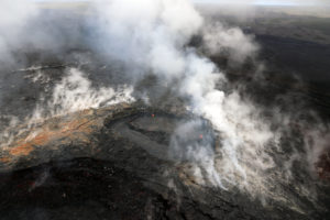
Kīlauea volcano is erupting. As of this morning, October 8, 2021, lava continues to erupt from a single vent in the western wall of Halemaʻumaʻu crater. All lava activity is confined within Halemaʻumaʻu crater in Hawai‘i Volcanoes National Park. Seismicity and volcanic gas emission rates remain elevated.
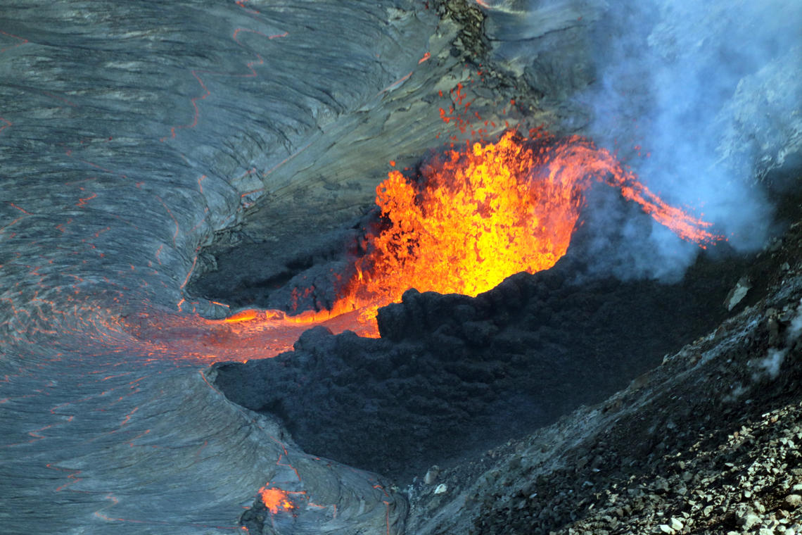
This photo was taken from the northwest caldera rim, providing a good view inside the cone, as well as a view of the small spillway supplying lava into the lake.
Summit Observations:
Sulfur dioxide (SO2) emission rates remain high, with a measured emission rate of approximately 4,700 tonnes per day on October 7, 2021-down from 7,000 tonnes per day yesterday. Seismicity remains elevated but stable. Summit tiltmeters continue to record deflationary tilt.
Halemaʻumaʻu Lava Lake Observations:
Lava continues to erupt from a single vent in the western wall of Halemaʻumaʻu crater and lava fountains from the vent have sustained heights of about 12 meters (39 ft). The western end of the lake shows a maximum elevation of approximately 777 meters (2549 ft) above sea level, which is an increase of about 2 meters (7 ft) over the past 24 hours and a total increase of about 34 meters (112 ft) since lava emerged on September 29. The lava lake is above the base of the vent and the fountain has built a spatter rampart around with an opening to the east.
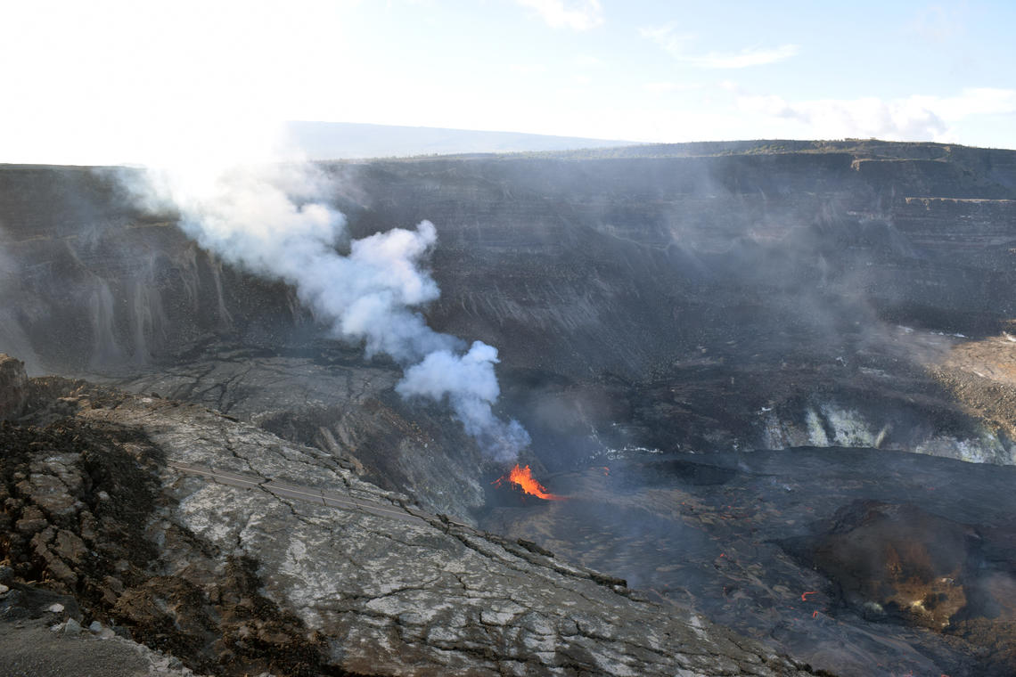
This view from the southern crater rim shows the west vent fountains (center) supplying lava into the western portion of the lava lake. SO2 gas emission rates remain elevated, and were measured at 4,700 tonnes per day on October 7.
The fountain is feeding lava to the lake by a flow through the rampart opening. The previously active vent in the south part of the lake is no longer visible. The central island and several of the smaller eastern islets from the 2020 lava lake are still above the lake surface along with an island of the 2020 western vent rampart in the northwest part of the lake. The lava lake is not level across its surface due to the location of the vent in the western end. Areas closer to the vent are about 1-2 meters (3-7 ft) higher in elevation compared to the north and south part of the lake and 7 meters (23 ft) higher than the east end of the lava lake. Active lava and crustal foundering is now mainly focused on the western part of the lava lake.
Source : HVO.
Photos : USGS / M. Patrick. USGS / L. DeSmither .
Alaska , Great Sitkin :
52°4’35 » N 176°6’39 » W,
Summit Elevation 5709 ft (1740 m)
Current Volcano Alert Level: WATCH
Current Aviation Color Code: ORANGE
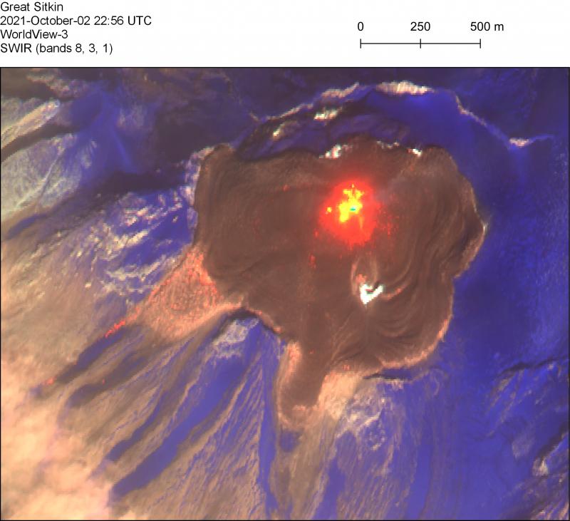
Lava effusion in the summit crater of Great Sitkin continued this week. A clear, high-resolution satellite image of the volcano summit from October 2, 2021 showed an active lava flow field with an area of about 970,000 square meters (240 acres) and an estimated volume of about 24 million cubic meters (32 million cubic yards). Two lobes of lava have flowed nearly 300 m (985 feet) beyond the crater rim on the west and southwest sides of the crater and lava has reached the crater rim on its northern periphery. The total area of the summit crater is about 1.7 million square meters (433 acres) and the extent of the lava flows as of October 2 indicates that lava now fills more than half of the summit crater. In a few areas, the lava has advanced over snow and ice but we have not observed any anomalous melting, steaming, or ponding of water indicating that melt rates are probably low and there are no indications of any imminent hydrologic hazards.
The lava lobes that have breached the summit crater are flowing into small valleys developed on the volcanic edifice. The terrain is steep in these areas and it may be possible for blocks of lava and lava rubble to detach from the terminus of the lava flows and form small rock avalanches in these valleys. Such avalanches may liberate ash and gas and could travel several hundred meters beyond the lava flows; they would be hazardous to anyone in those areas.
The level of seismicity was slightly elevated throughout the past week and there were persistent small earthquakes likely associated with the ongoing lava effusion. Elevated surface temperatures were observed in satellite data over the past week when views of the volcano were not obscured by clouds. No explosive activity or ash emissions have been detected in seismic, infrasound, satellite, or web camera data.
There is no indication of how long lava effusion will continue during the current eruption, and it is possible that explosive activity could occur with little or no warning.
Great Sitkin Volcano is monitored by local seismic and infrasound sensors, satellite data, web cameras, and remote infrasound and lightning networks.
Source : AVO
Photos : Loewen, Matt.
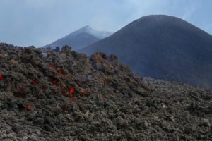
Chile , Nevados de Chillan :
Special Report on Volcanic Activity (REAV), Ñuble region, Nevados de Chillán volcanic complex, October 08, 2021, 3:25 p.m. local time (Continental Chile).
The National Service of Geology and Mines of Chile (Sernageomin) publishes the following PRELIMINARY information, obtained thanks to the monitoring equipment of the National Volcanic Monitoring Network (RNVV), processed and analyzed at the Volcanological Observatory of the Southern Andes ( Ovdas):
On Friday 08 October 2021, at 15:02 local time (18:02 UTC), the monitoring stations installed near the Nevados de Chillán volcanic complex recorded an earthquake associated with fluid dynamics (long period type) in the volcanic system.
The characteristics of earthquakes after their analysis are as follows:
TIME OF ORIGIN: 3:02 p.m. local time (18:02 UTC)
LATITUDE: 36.854 ° S
LONGITUDE: 71.372 ° W
DEPTH: 1.4 km
REDUCED DISPLACEMENT: 503.07 (cm2)
ACOUSTIC SIGNAL: 4.41 pascals (Pa) reduced to 1 km
The characteristics of the surface activity are as follows:
MAXIMUM HEIGHT OF THE COLUMN: 340 meters above the point of emission
DIRECTION OF DISPERSAL: South-West.
OBSERVATIONS:
The volcanic technical alert remains at the Yellow level.
Source : Sernageomin.
Photo : Cegemar.
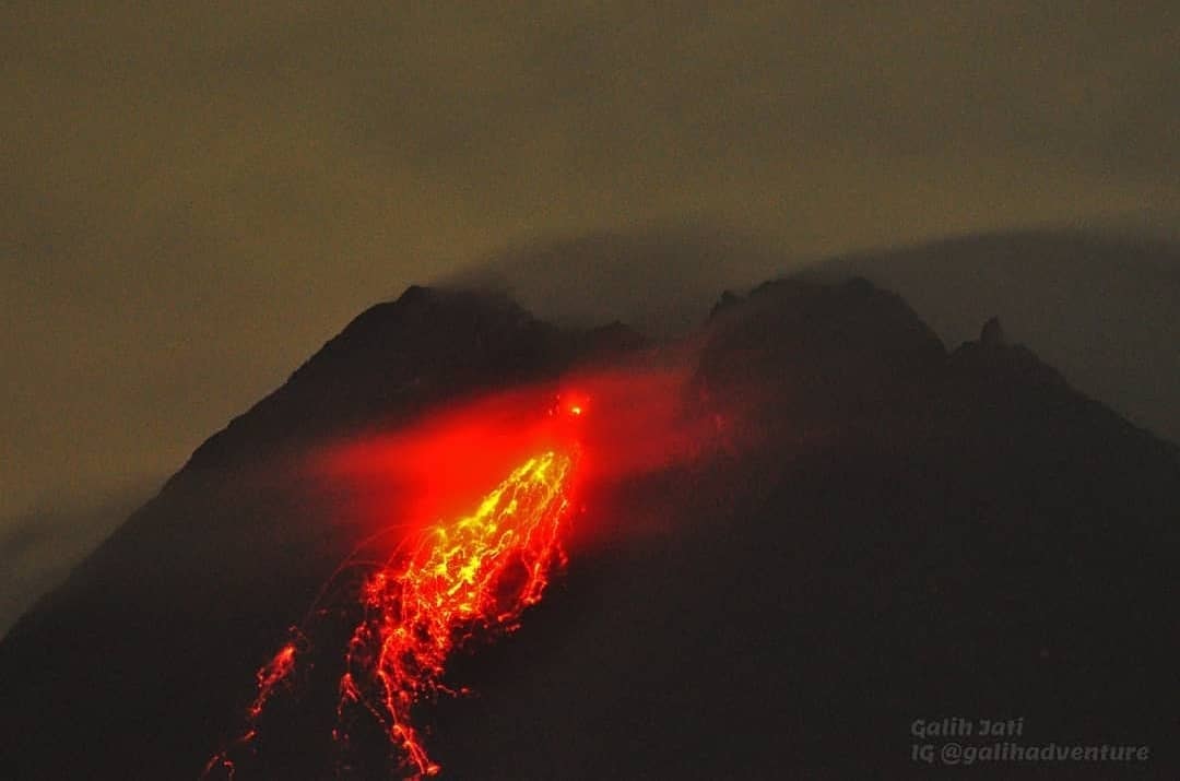
Indonesia , Merapi :
Mount Merapi Activity Report, October 1-7, 2021
OBSERVATION RESULTS
Visual
The weather around Mount Merapi is generally sunny in the morning and evening, while it is foggy in the afternoon. White, weak to thick, low pressure, 200m high smoke was observed from the Mount Merapi observation post in Kaliurang on October 4, 2021 at 07:00 WIB. Lava avalanches were observed 76 times southwest with a maximum slide distance of 2000 m.
An increase in the height of the southwest lava dome of about ± 3 m was observed. The volume of the southwest lava dome is 1,679,000 m3 and the central dome is 2,854,000 m3.
Seismicity.
This week, the seismicity of Mount Merapi showed:
1 shallow volcanic earthquake (VTB),
70 low frequency earthquakes (LF),
902 multi-phase earthquakes (MP),
1068 avalanche earthquakes (RF),
127 emission earthquakes (DG),
5 tectonic earthquakes (TT).
This week’s seismicity was lower than last week, but still of high intensity.
Deformation.
The deformation of Mount Merapi which was monitored using EDM and GPS this week showed no significant changes.
Rain and lahars.
This week, it rained at the Mount Merapi observation post with an intensity of 12 mm / hour for 50 minutes at Kaliurang post on October 6, 2021. There were no reports of lahars or additional flow in the mountains. rivers that originate from Mount Merapi.
Conclusion.
Based on the results of visual and instrumental observations, it is concluded that:
The volcanic activity of Mount Merapi is still quite high in the form of effusive eruption activity. The status of the activity is defined in the “SIAGA” level.
Source : BPPTKG.
Photo : galih jati