February 19 , 2021 .
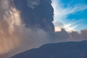
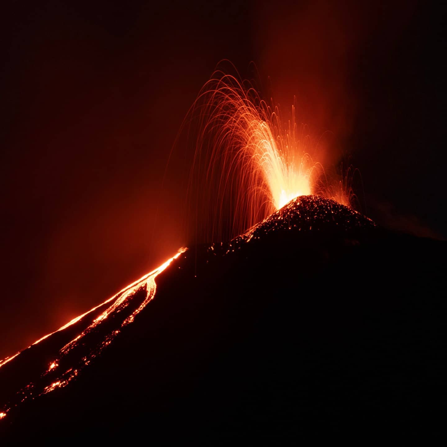
Italy / Sicily , Etna :
COMMUNICATION ON THE ACTIVITY OF ETNA [UPDATE n. 139]
The National Institute of Geophysics and Volcanology, Osservatorio Etneo, announces that with the help of surveillance cameras a new lava overflow from the Southeast Crater is observed
, which started just before 07:55 UTC. The lava flow descends the eastern slope of the cone, heading towards the Valle del Bove. The amplitude of the tremor increases.
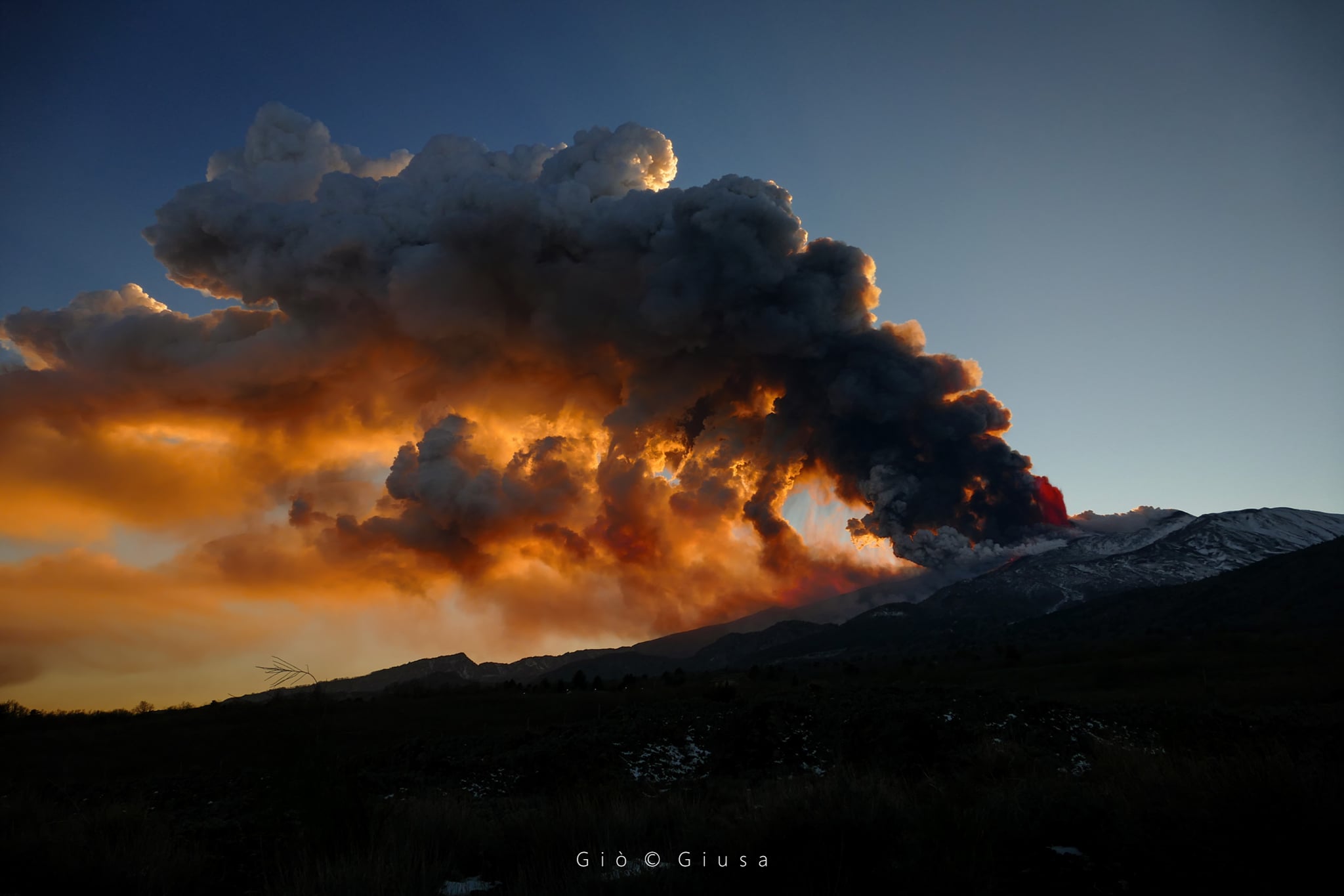
COMMUNICATION ON THE ACTIVITY OF ETNA [UPDATE n. 140]
The National Institute of Geophysics and Volcanology, Osservatorio Etneo reports that after the initial lava overflow on the eastern flank of the Southeast Crater, there is a rapid increase in Strombolian activity from the same crater and from the feeding the lava flow. In addition, an intense gas plume is forming, currently without a significant amount of ash. The average amplitude of the volcanic tremor shows high values with an increasing trend.
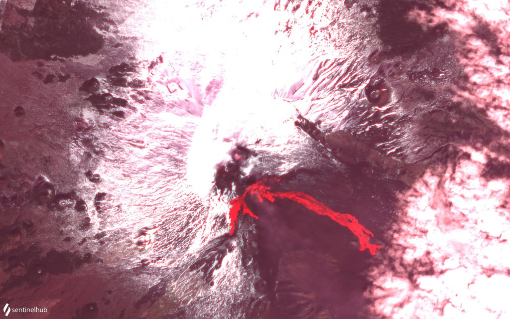
Image acquired by the ESA Sentinel2 satellite on February 18, on visible spectrum RGB + infrared (SWIR – 2190 nm). We can see the flows produced by the paroxysm of February 18, towards the Bove Valley (the longest), the M. Frumento Supino (towards the South-South-West) and the Valle del Leone (the smallest towards the Northeast ).
The source of the tremor is located under the Southeast Crater, at a depth of about 2700 m above sea level.
The infrasonic activity also shows high values of the rate of occurrence and the energy of infrasonic transients, with a tendency to increase.
Further updates will be communicated shortly.
Source : INGV.
Photos : Gio Giusa , INGV.
Kamchatka , Ebeko :
VOLCANO OBSERVATORY NOTICE FOR AVIATION (VONA).
Issued: February 19 , 2021
Volcano: Ebeko (CAVW #290380)
Current aviation colour code: ORANGE
Previous aviation colour code: orange
Source: KVERT
Notice Number: 2021-27
Volcano Location: N 50 deg 41 min E 156 deg 0 min
Area: Northern Kuriles, Russia
Summit Elevation: 1156 m (3791.68 ft)
Volcanic Activity Summary:
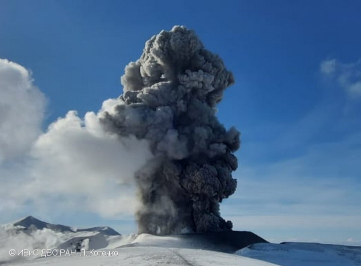
A moderate eruptive activity of the volcano continues. According to visual data by volcanologists from Severo-Kurilsk, explosion sent ash up to 3.1 km a.s.l., an ash cloud is drifting to the southeast of the volcano.
This activity continues. Ash explosions up to 6 km (19,700 ft) a.s.l. could occur at any time. Ongoing activity could affect low-flying aircraft and airport of Severo-Kurilsk.
Volcanic cloud height:
3100 m (10168 ft) AMSL Time and method of ash plume/cloud height determination: 20210219/0542Z – Visual data
Other volcanic cloud information:
Distance of ash plume/cloud of the volcano: 3 km (2 mi)
Direction of drift of ash plume/cloud of the volcano: SE
Time and method of ash plume/cloud determination: 20210219/0542Z – Visual data
Source : Kvert .
Photo : L. Kotenko. IVS FEB RAS.
New Zealand , White Island :
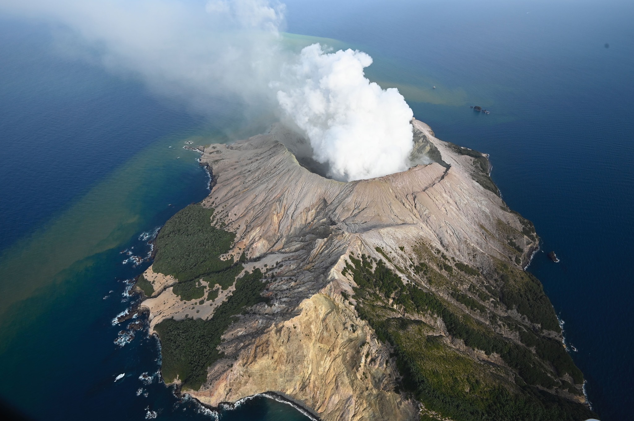
Minor steam explosions at Whakaari/White Island , Published: Fri Feb 19 2021 11:30 AM
A series of short-lived, low-energy steam explosions occurred on 19 February 2021 at Whakaari / White Island following a small increase in volcanic tremor levels. These explosions took place over about 100 minutes. These small events do not appear to have produced any traces of ash locally. Since the event, activity has returned to low-level. The Volcanic Alert Level remains at 1.
Starting at around 2.20 am today (19 February) our seismic and acoustic (air pressure) sensors at Whakaari/White Island detected a series of small steam explosions. No observations were available from the island’s webcams as it was still dark. The overall series of pulses lasted for about 100 minutes and were of a similar size to those recorded on 29 December 2020. Volcanic tremor levels started to rise around 9 pm on 18 February and stopped around 5.50am today coincident with the end of the explosions.
Sudden, small steam explosions can occur with little or no warning. Small explosions like those this morning and on 29 December 2020 can be recorded on our seismic (ground vibrations) and acoustic (pressure wave in the atmosphere) monitoring network.
A gas flight was completed yesterday (18 February) showed no changes in gas flux or crater conditions from a month earlier. The level of seismic tremor had been slightly above background in the two days preceding the explosions but has since returned to background levels. As a result, the Volcanic Alert Level remains at 1 and the Aviation Colour Code remains at Green.
GNS Science and the National Geohazards Monitoring Centre continue to closely monitor Whakaari for further changes in unrest. .
Source : Geonet .
Photo : George Novak
Chile , Villarica :
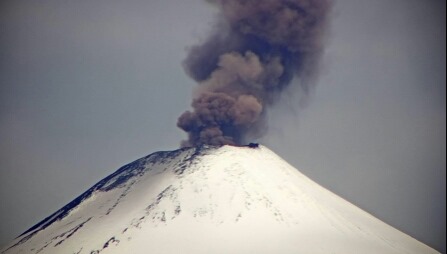
Special Report on Volcanic Activity (REAV), La Araucanía region, December 17, 2020, 5:50 p.m. local time (Continental Chile).
The National Geological and Mining Service of Chile (Sernageomin), on the basis of information obtained through the monitoring equipment of the National Volcanic Monitoring Network (RNVV), processed and analyzed at the Volcanological Observatory of the Southern Andes (Ovdas ), and in relation to the activity of the Villarrica volcano, reports the following:
On Thursday, December 17, at 5:16 p.m. local time (8:16 p.m. UTC), IP cameras installed near the volcano recorded a pulse of particulate matter, associated with a long-period earthquake (LP).
The data obtained are as follows:
MAXIMUM COLUMN HEIGHT: 720 m with particle emission.
DISPERSAL DIRECTION: East-South-East (ESE)
REDUCED DISPLACEMENT: 7.7 cm2
Observations:
At the time of publication of this report, the monitoring parameters do not show significant variations.
The volcanic alert remains at the Yellow level.
Source et photo : Sernageomin .
Guatemala , Pacaya :
SPECIAL VOLCANOLOGICAL BULLETIN.
VOLCANIC ACTIVITY UPDATE
As an extension of the special bulletin BEPAC 011-2021 and BEPAC 026-2021, the seismic monitoring parameters reflect a new boost from 9:00 a.m. (local time) today, which confirms that volcanic activity continues at high levels. In the Mackenney crater, incandescent materials continue to be generated and expelled at a height of 200 meters with explosions of low to moderate characteristics continuously. The column of ash and gas rises to a height of 3000 m above sea level (9842 feet), dispersed in the direction of the wind over the Pacaya volcano, which is variable, mainly north-easterly and southerly winds. A sound similar to that of a train locomotive is constantly reported, indicating high dynamics inside the volcano.
In the area in front of the plateau there are areas with high temperatures. The lava flow on the southern flank is still active and has a length of about 1,100 meters, in front of the flow, blocks are released with high temperatures.
It is not excluded that the volcanic activity generates new impulses of increase in the coming hours or days. It is important to remember that the direction of the wind is variable, thus dispersing the ash in several directions. The INSIVUMEH ensures permanent visual and instrumental monitoring, through seismic stations and OVPAC observers.
Source : Insivumeh .
Photo : @diegorizzophoto