December 08 , 2020.
La Réunion , Piton de la Fournaise :
Activity bulletin for Monday December 7 at 15:50 (local time)
Alert level: 2-2
The eruption that started on 12/07/2020 around 4:40 am (appearance of the volcanic tremor) continues. The intensity of the volcanic tremor (indicator of the intensity of the eruption) after an increase phase at the start of the eruption, has been falling since 6 a.m. (local time, 2 a.m. UT time), even if this decrease has been decreasing since 9:15 a.m. (local time, 5:15 am UT; Figure 1).
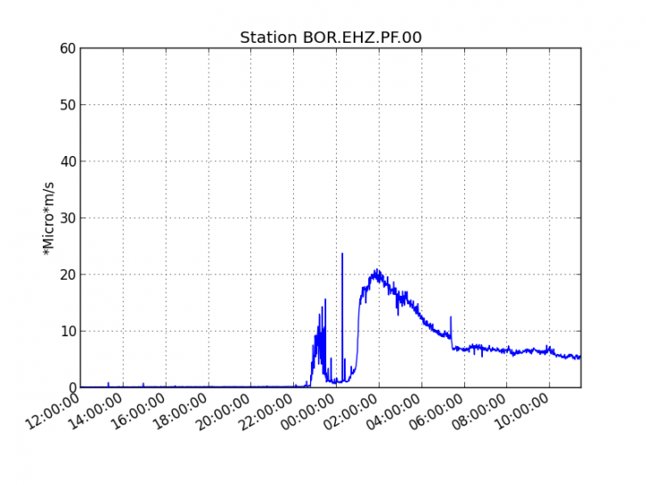
Figure 1: Evolution of the RSAM (indicator of the volcanic tremor and the intensity of the eruption) since 12/06/2020 4 p.m. local time (12 p.m. UT) on the BOR seismological station located to the south-west of the Bory crater (© OVPF / IPGP).
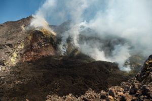
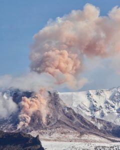
At 3 p.m. local time, the highest crack in altitude was the most active with the formation of 5 small eruptive vents (Figure 2). The two lower cracks showed a noticeable drop in activity. OVPF-IPGP field teams were able to sample the gas and volcanic bombs.
Figure 2: Shots of the eruptive site on 12/7/2020 around 2:15 p.m. local time (© OVPF / IPGP).
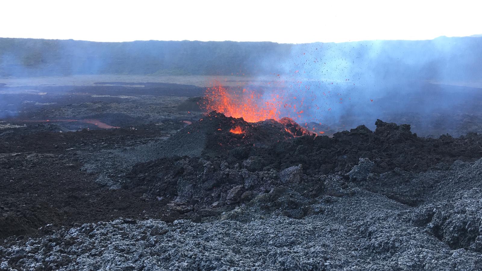
Figure 2: Shots of the eruptive site on 12/7/2020 around 2:15 p.m. local time (© OVPF / IPGP).
The estimated surface flows, from satellite data via the HOTVOLC platform (OPGC – University of Auvergne), show flows for the day of 7/12/2020 of between 5 and 30 m3 / s.
Activity bulletin for Tuesday, December 8 at 8:00 a.m. (local time)
Recommended alert level: Backup
The eruption which started on 12/07/2020 around 4:40 a.m. (appearance of the volcanic tremor) stopped today, on 12/08/2020 around 7:15 a.m. local time (3:15 a.m. UT; Figure 1), following a gradual decrease in the tremor and a 3 hour phase of « gas piston » at the eruptive site (gas puff or intermittent tremor) which are generally observed when the quantity of gas available is exhausted, and often synonymous with a decrease surface activity.
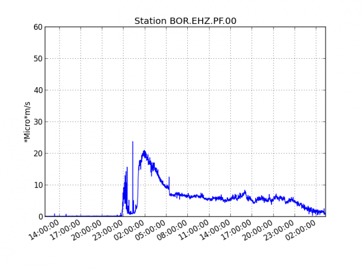
Figure 1: Evolution of the RSAM (indicator of the volcanic tremor and the intensity of the eruption) since 12/06/2020 4 p.m. local time (12 p.m. UT) on the BOR seismological station located to the south-west of the Bory crater (© OVPF / IPGP).
No more surface activity is observed but no hypothesis is ruled out as to the evolution of the future situation (permanent shutdown, resumption of activity on the same site, resumption of activity elsewhere), seismicity still being recorded under the summit of the volcano.
Source : OVPF.
Read the article : http://www.ipgp.fr/fr/ovpf/bulletin-dactivite-lundi-7-decembre-a-1550-heure-locale
Photos : OVPF.
Russia / Kuril Islands , Ebeko :
VOLCANO OBSERVATORY NOTICE FOR AVIATION (VONA).
Issued: December 08 , 2020
Volcano: Ebeko (CAVW #290380)
Current aviation colour code: ORANGE
Previous aviation colour code: orange
Source: KVERT
Notice Number: 2020-233
Volcano Location: N 50 deg 41 min E 156 deg 0 min
Area: Northern Kuriles, Russia
Summit Elevation: 3791.68 ft (1156 m)

Volcanic Activity Summary:
A moderate eruptive activity of the volcano continues. According to visual data by volcanologists from Severo-Kurilsk, explosion sent ash up to 3.5 km a.s.l., an ash cloud is drifting to the northeast of the volcano.
This activity continues. Ash explosions up to 19,700 ft (6 km) a.s.l. could occur at any time. Ongoing activity could affect low-flying aircraft and airport of Severo-Kurilsk.
Volcanic cloud height:
9840-11480 ft (3000-3500 m) AMSL Time and method of ash plume/cloud height determination: 20201208/0128Z – Visual data
Other volcanic cloud information:
Distance of ash plume/cloud of the volcano: 2 mi (3 km)
Direction of drift of ash plume/cloud of the volcano: NE
Time and method of ash plume/cloud determination: 20201208/0128Z – Visual data
Source : Kvert .
Photo : S. Lakomov , 26/9/2020.
Peru , Sabancaya :
Analysis period: from November 30 to December 06, 2020, Arequipa, December 07, 2020.
Alert level: ORANGE
The Geophysical Institute of Peru (IGP) reports that the eruptive activity of the Sabancaya volcano remains at moderate levels, that is, with the continuous recording of explosions with columns of ash and gas up to 2 km altitude above the summit of the volcano and their consecutive dispersion. It has been reported the presence of a second lava dome, visible in the crater of the volcano. Therefore, for the following days, no significant change is expected regarding the eruptive activity.

The IGP recorded and analyzed the occurrence of 1450 earthquakes of volcanic origin, associated with the circulation of magmatic fluids inside the Sabancaya volcano. An average of 26 explosions were recorded daily of low to medium intensity. During this period, Volcano-Tectonic (VT) earthquakes were located mainly in the North-East of Sabancaya and presented magnitudes between M1.4 and M2.8. The most representative earthquake (M2.8) was recorded on December 5 at 3.39 a.m., 18 km northeast of Sabancaya and 11 km deep.
The monitoring of the deformation of the volcanic structure using GNSS techniques (processed with fast orbits) does not present any significant anomalies. However, in general, an inflation process has been observed in the south-eastern sector of Sabancaya and the north sector (Hualca Hualca volcano). Visual surveillance made it possible to identify columns of gas and ash up to 2 km altitude above the summit of the volcano, which were scattered towards the North-East, West and South-East sectors of Sabancaya. Satellite monitoring has identified the presence of 7 thermal anomalies with values between 1 MW and 23 MW, associated with the presence of a new lava dome on the surface of the volcano crater, formed in November 2020.
RECOMMENDATIONS
• Keep the volcanic alert level in orange.
• Do not approach within a radius of less than 12 km from the crater.
Source : IGP.
Photo : Zintia Roxana Fernández Licla.
Mexico , Popocatepetl :
December 07, 11:00 a.m. (December 07, 5:00 p.m. GMT)
During the last 24 hours, according to the monitoring systems of the Popocatépetl volcano, 93 exhalations and 448 minutes of tremor have been identified, accompanied by emissions of volcanic gases and, on occasion, ash. In addition, two volcano-tectonic-type earthquakes were recorded yesterday at 12:22 p.m. and today at 7:52 a.m., with a calculated magnitude of 2.1 and 2.0, respectively.
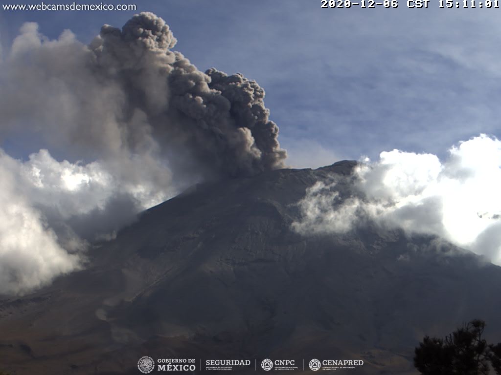
Since this morning and at the time of this report, we observe a continuous emission of volcanic gases and sometimes ash, which disperse in a north-easterly direction.
CENAPRED urges NOT TO APPROACH the volcano and especially the crater, because of the danger posed by the fall of ballistic fragments and, in the event of heavy rains, to stay away from the bottom of the ravines because of the danger of lava flows. mud and debris.
The Popocatépetl volcanic alert semaphore is in YELLOW PHASE 2.
Source and photo : Cenapred.