July 04 , 2020 .
Ecuador , Sangay :
Thanks to the management provided by the National Risk and Emergency Management Service (SNGRE), the staff of the Geophysical Institute of the National Polytechnic School (IG EPN) was able to count on the logistical support of the Army Aviation Group n ° 45 Pichincha, to carry out a surveillance overflight of the Sangay volcano (Fig. 1) on June 24, 2020. Several objectives have been planned, among which we can cite: control of surface activity, evaluation of morphological changes , thermography and measurement of volcanic gases. Thanks to this work, valuable data has been obtained which helps to study the activity of the volcano.

Figure 1. Aerial photograph of the Sangay volcano taken from the Southeast, to the right of the photo, you can see the Chimborazo volcano. The flow formed by continuous erosive processes is observed, as well as a column of ashes resulting from a small explosion which occurred in the central crater. The column reached 500 m above the summit and headed west. Photo: M Almeida, IG EPN.
Flight path and conditions:
The overflight took place on the morning of June 24 from the Army Air Group runway at Río Amazonas airport located in the Shell parish of Cantón Mera, province of Pastaza. It was carried out in variable climatic conditions, with the presence of low clouds which covered the base of the volcano. The presence of scattered ash in the environment limited the overflight to the North, East and South areas of the volcano (Fig. 2). For this reason, the scheduled maintenance could not be carried out at the SAGA station, located on its SW flank. The overflight lasted approximately two hours.

Aerial surveillance.
Surface activity:
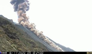
During the overflight, it was observed that the surface activity of the volcano was characterized by the generation of small explosions and pyroclastic flows. The explosions produced small columns of gas with a high ash content, which did not exceed 500 meters above the summit and were dispersed to the west (Fig. 1 and Fig. 3 on the left). The displacement and deposition of pyroclastic flows were limited to the internal part of the ravine on the south-eastern flank, while its ashes were quickly displaced in the form of columns which reached about 200 meters above the surface of the ravine and, due to the action of the winds were dispersed from the southern flank to the west, surrounding the volcano (Fig. 3 Der.). Together, the emissions and columns derived from pyroclastic flows contribute to a large amount of ash in the environment. Transported by the winds, these ashes reached populations located in its path.
Thermal anomalies:
According to the acquisition and analysis of thermal or infrared images, it was possible to observe the presence of different anomalies (areas with a temperature higher than the environment) on the southeast flank of the volcano ( Fig. 4). Thanks to the construction of thermal image mosaics, these anomalies are represented from different angles in Figure 4 (below). In its relief, it is obvious that in the upper part of the ravine there are two very marked thermal anomalies; while the third is scattered and heterogeneous towards the base of the ravine, the edge of which is represented by the solid black line (Fig. 4, above). Analysis showed that Anomaly 1 had a temperature of 125 ° C, which was associated with explosive activity, during the overflight. Anomaly 2 could be linked to effusive activity, with the potential presence of a small lava flow whose maximum temperature reached 147 ° C. Finally, the third anomaly corresponds to the accumulation of hot deposits of pyroclastic flows in the lower part of the Southeast ravine with temperature values of 165 ° C.
It should be mentioned that the amount of ash and gas covering these deposits at the time of image capture considerably reduces the measured temperature values, which can indeed be higher for each anomaly.
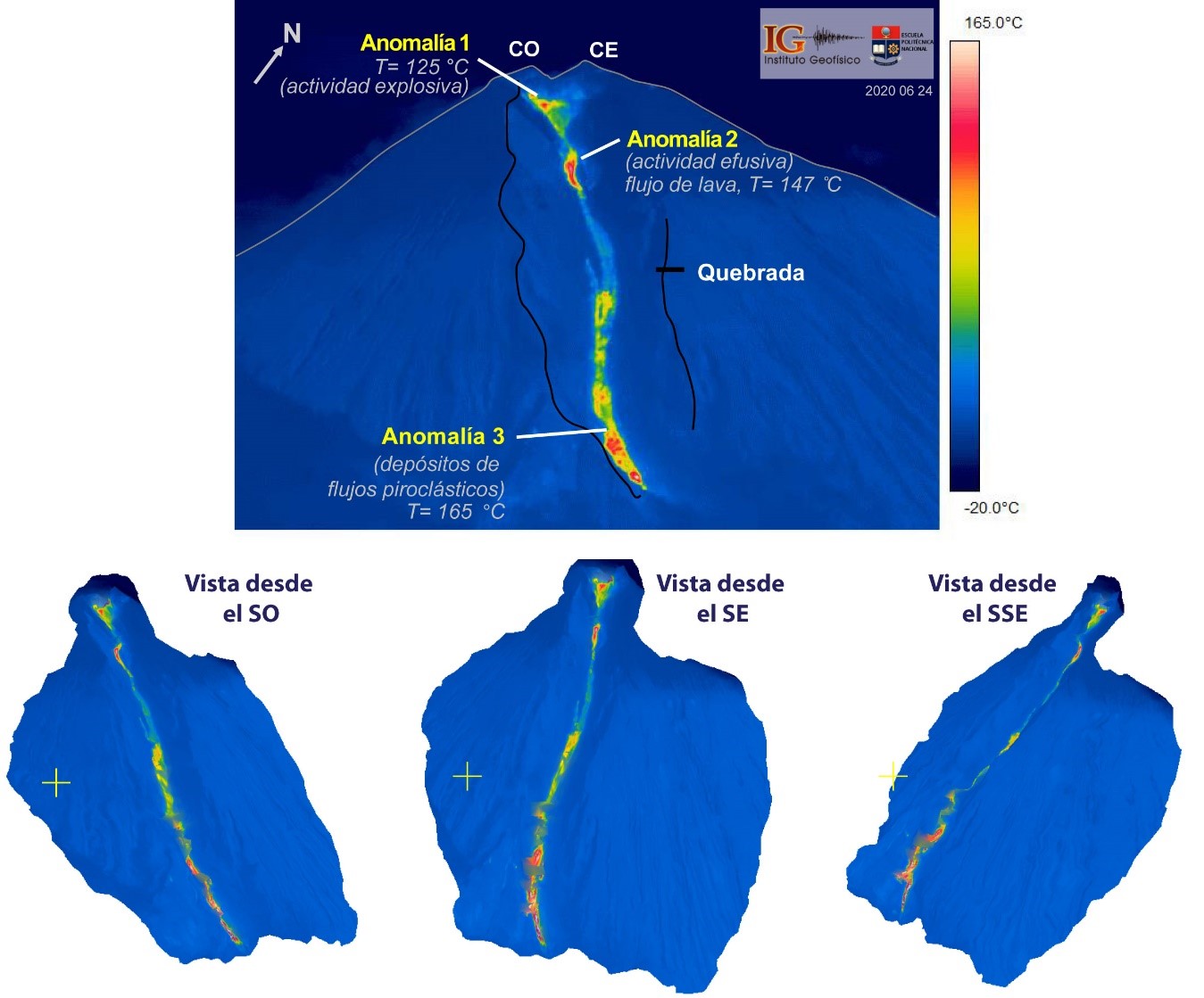
Figure 4. Above: thermal image of the southeast flank of the Sangay volcano, the highest temperature zones: yellow-red-white and the lowest temperature zone: dark blue. The escarpment of the ravine formed in this eruptive phase (black line) is shown, which shelters thermal anomalies linked to explosive activity, effusion and deposits of pyroclastic flows. Bottom: thermal image mosaics of the gorge on the Southeast flank with three views, from left to right: Southwest, Southeast and East-Southeast. Thermal image and mosaics: S Vallejo Vargas, IG EPN.
Morphology:
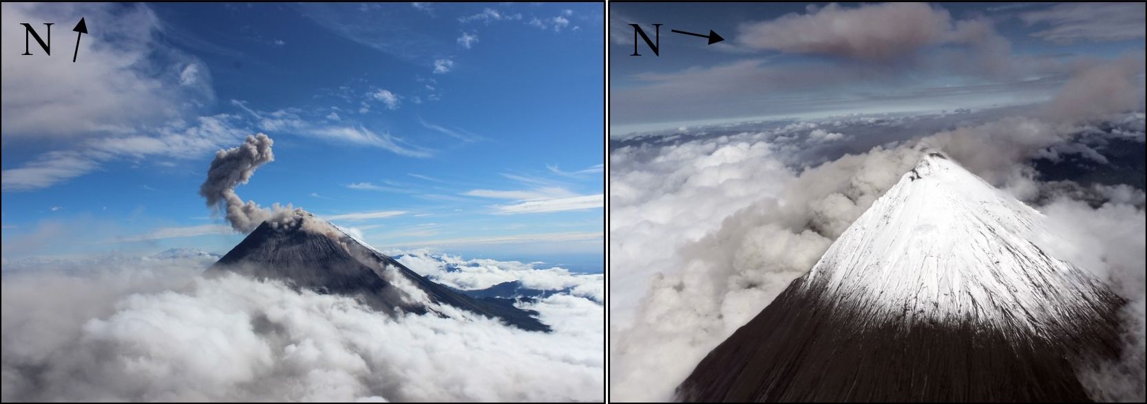
The morphology of the volcano has changed dramatically and continuously in this last eruptive phase which started in May 2019. These changes have shown that the summit of the volcano now has at least two maximum elevations, separated by a relatively small saddle of about 181 meters wide, possibly formed by the erosion of the northwest wall of the crater. Figure 5 shows the estimate of the width of the Southeast gorge in its upper part, with about 397 m.

Figure 5. Left: processed amplitude image, which was used to contrast certain measurement estimates in the most relevant morphological characteristics (amplitude image http://www.mounts-project.com/volcano/352090, Track Ascending June 30, 2020). Right: approach to the summit of the Sangay volcano, accompanied by an illustration which highlights its new morphological characteristics. Photo: M Almeida, IG EPN.
In the photographic sequence of Figure 6, we can synthetically observe the change that the volcano has undergone since May 2019. This sequence includes two photographs and a thermal image, which were captured in the same direction (N100 °) and altitude (5644 m / 18517 ft), May 17, 2019 and June 24, 2020, respectively. The area of fumaroles aligned in the vicinity of the summit of the volcano was used as a clear reference for the superimposition of said images (see Ref. Fumerole aligned in Fig. 5 and Fig. 6). Thanks to this, it was possible to confirm that the top of the volcano was eroded, showing a complete change, compared to the configuration of May 2019, when the current eruptive phase had just started. Apparently, the height of the volcano could have changed, however, to confirm, this will require the development of digital terrain models, with the appropriate conditions in terms of climate and absence of ash in the environment.
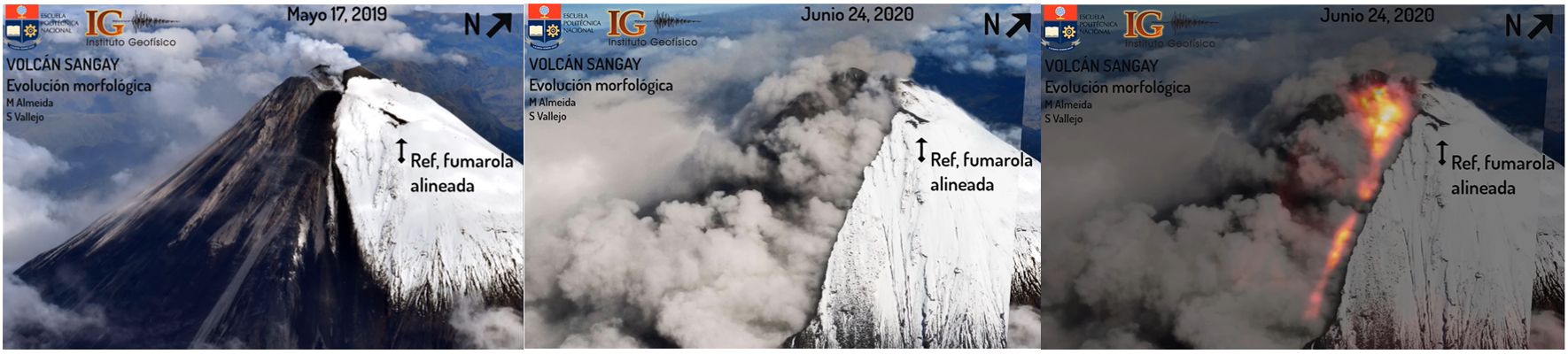
Figure 6. Aerial and thermal photographic sequence of the southern flank of the Sangay volcano for the dates of May 17, 2019 (left: visible image) and June 24, 2020 (middle: visible image, right: visible-thermal overlay) where is shown morphological changes on this flank, associated with the formation of a ravine on the southeast flank and the modification of the summit. Photos / Thermal image: M Almeida, IG EPN.
Here is the video of the animation of the sequence:
Gas:
During the overflight, it was possible to transport equipment to measure the concentration of volcanic gases (MultiGAS), this equipment has a data processor, a laptop and a special hose system which is located at outside, under the helicopter. The main considerations are as follows: prevent gases escaping from the aircraft from entering the equipment, which affects potential measurements (Fig. 7).
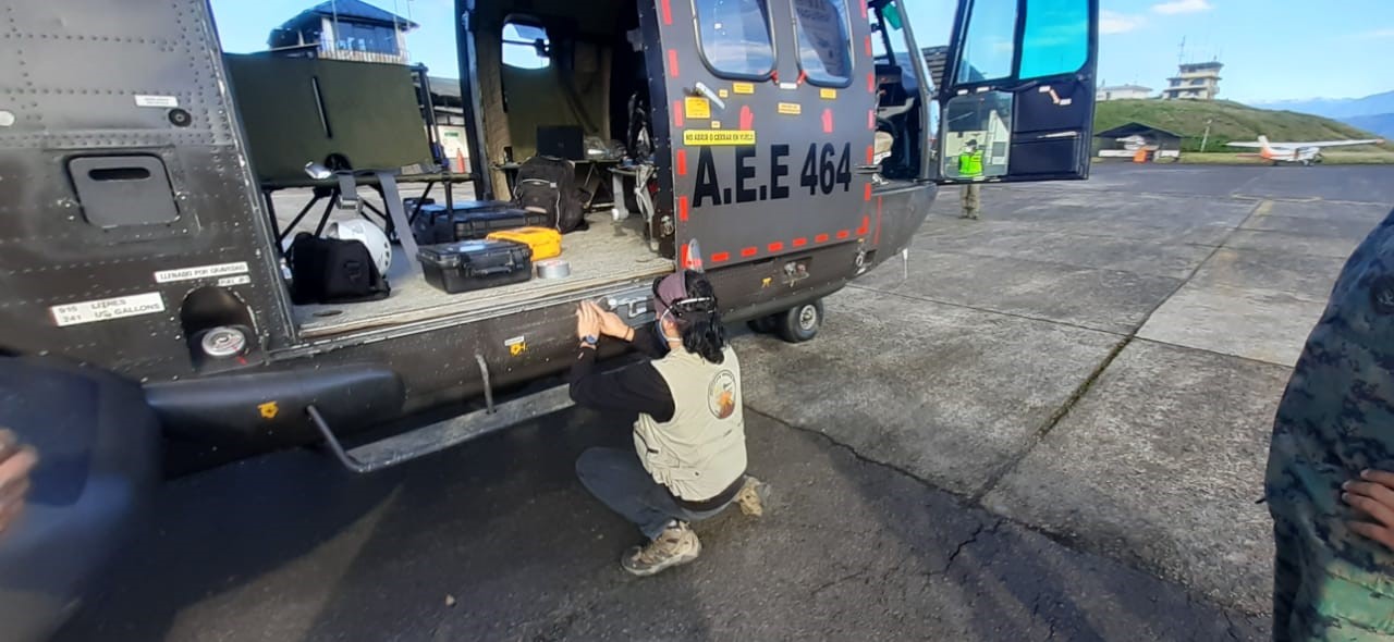
Figure 7. The MultiGAS equipment consists of a complex system of sensors, data processors and special pipes, which are installed on the plane before takeoff, so that they are not contaminated by the system. engine exhaust. (Photo: E. Camacho Chamba, CBOP of 2op A.E.).
Unfortunately, the presence of ashes in the work area did not allow the maneuvers necessary to obtain said data. In FIG. 8, it is possible to observe the maneuvers carried out, which are limited to the eastern flank. The gases that this equipment can measure are: sulfur dioxide (SO2), hydrogen sulfide (H2S), carbon dioxide (CO2) and water (H2O). Figure 8 shows the set of data collected and analyzed, where the gas concentrations of the volcano were not observed (Figure 8). The yellow arrow indicates the start of the measurements.

Conclusions:
1. The summit has undergone significant changes, where we can distinguish two altitudes derived from the continuous erosion of the edges of the Southeast gorge.
2. We observe that the escarpments which start from the summit and extend towards the south-eastern flank, represent the edges of a ravine with a maximum width of approximately 397 meters, which shelters two anomalies in its upper part and a in its lower part.
3. Anomaly 1 is related to explosions which are used to form columns of gas and ash of different heights and which are dispersed in the environment depending on the wind direction.
4. Anomaly 2 is potentially linked to the generation of lava flows, the movement of which is controlled by the morphology of the ravine.
5. The formation and deposition of pyroclastic flows is a continuous phenomenon, limited to the abovementioned ravine and at the base of the cone.
6. The measurements made with the multigas equipment did not make it possible to record the gas concentrations associated with the magmatic emissions. This is due to the impossibility of crossing the gas plume due to the quantity of ash in the environment.
7. On the date of the overflight, the level of surface activity of the Sangay remained at the level of surface activity considered to be: HIGH with the trend: No change.
General recommendations
Do not approach the dangerous areas of the Sangay volcano; in the event of ash fall, protect yourself with a mask, safety glasses and limit your exposure (more information: http://www.ivhhn.org/es/ash-protection); stay informed of the evolution of eruptive activity on the website of the Institute of Geophysics and on its official social networks; follow the recommendations of the risk and emergency management authorities (SNGRE, ECU911 and GAD provincial and cantonal).
Source : IGEPN.
Read the article : https://www.igepn.edu.ec/servicios/noticias/1821-informe-del-sobrevuelo-al-volcan-sangay-el-24-de-junio-de-2020
La Réunion , Piton de la Fournaise :
21 ° 14’38 « S
55 ° 42’29 « E
Altitude: 2632m
Alert level: Alert 1
Seismology:
– Number of landslides from 03-07-2020: 7
Zone affected by landslides:
Out of enclos :
– Number of volcano-tectonic earthquakes (VT) of 03-07-2020: 202
Zone concerned by the VT:
Summit cone
– Larger magnitude volcano-tectonic earthquake of 03-07-2020: Duration: 14.16 s
Duration magnitude: 1.43.
Deformations:
– The GPS in the summit area registers an inflation, witnessing the pressurization of a surface source.
– The GPS in the far field records an inflation, witnessing the pressurization of a deep source.

Illustration of the deformation over 2 months. Here are shown baselines (variation in distance between two GPS receivers) crossing the Piton de la Fournaise building, at the top (top), at the base of the terminal cone (in the middle) and in the far field (bottom ) (see location on associated maps). An increase is synonymous with elongation and therefore swelling of the volcano; conversely, a decrease is synonymous with contraction and therefore deflation of the volcano. Any periods colored in light pink correspond to eruptions.
Source : OVPF.
Indonesia , Merapi :
Activity report of the Merapi volcano, June 26-July 2, 2020
OBSERVATION RESULTS
Visual
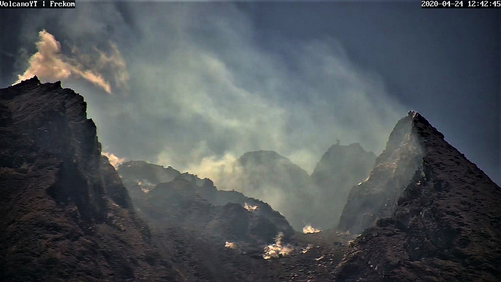
The weather around Mount Merapi is generally sunny in the morning and at night, while the day until evening is foggy. White smoke, thin to thick with low pressure is observed. A maximum smoke height of 150 m was observed from the Mount Merapi observation post in Kaliurang on June 28, 2020 at 5:44 p.m.
Morphological analysis of the crater area based on photos of the Southeast sector showed no change in the morphology of the dome. The volume of the lava dome based on measurements using aerial photos with drones on June 13, 2020 was 200,000 m3.
Seismicity:
This week, the earth seismicity of Mount Merapi recorded:
26 emission earthquakes (DG),
5 volcanic earthquakes (VTA),
2 shallow volcanic earthquakes (VTB),
75 multi-phase earthquakes (MP),
2 low frequency earthquakes (LF),
24 times an earthquake (RF),
15 tectonic earthquakes (TT).
This week’s seismicity was dominated by MP events, the number of which was higher than last week.
Deformation
The deformation of G. Merapi, who was monitored by EDM this week, showed a shortening of distance by ± 2 cm.
Rain and lahars:
There was no rain or lahars reported this week, nor additional flow in the rivers that descend from Mount Merapi.
Conclusion
Based on the results of the visual and instrumental observations, it was concluded that:
1. The lava dome is currently in a stable state.
2. The volcanic activity of Mount Merapi is still quite high and determined by the level of activity « WASPADA ».
Source : BPPTKG.
Photo : Frekom ( archives)
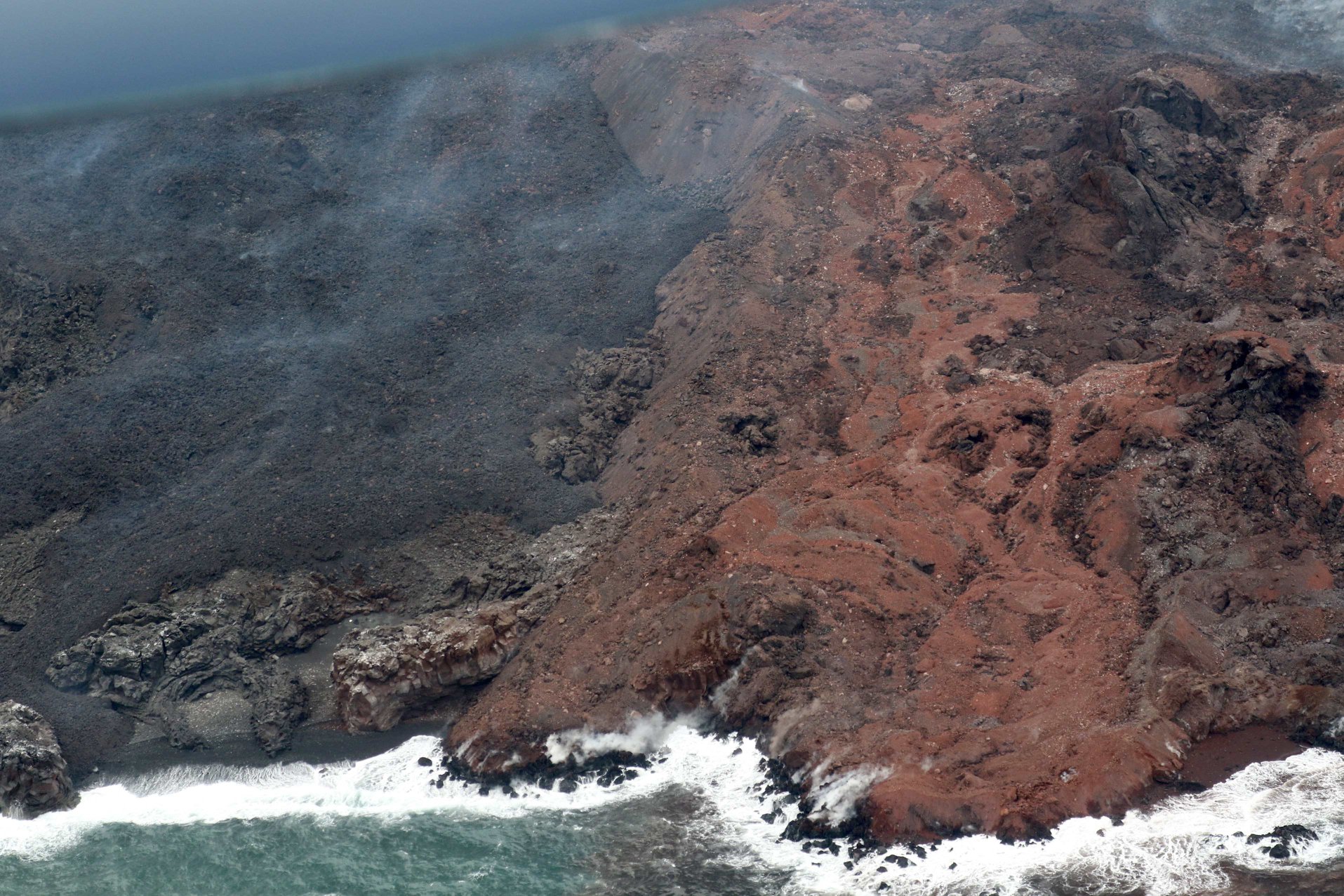
Japan , Nishinoshima :
Nishinoshima, 4700m, highest volcanic plume in the history of this volcano, 16:07, July 3, 2020.
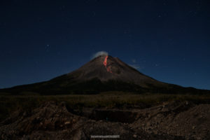
On Nishinoshima, in the Ogasawara Islands, active eruptive activity continues, with the highest emission of smoke observed at 4,700 meters. It has also been confirmed that a large amount of lava is flowing and that the island continues to expand. Future activities attract attention.
Observation by the Japanese Meteorological Agency’s « Himawari-8 » weather satellite confirmed that the plume reached 4,700 meters, the highest in the history of the observation, at 3:00 p.m. An investigation by the Japanese Coast Guard last 29 months confirmed that there was a « Strombolian » eruption that continuously ejected hot magma from the crater in the center of the island. It has also been confirmed that the rim of the crater has been destroyed and that a large amount of lava has flowed to the southwest of the island to reach the sea. The island is still expanding.
Regarding Nishinoshima, the Japanese Meteorological Agency continues to issue an « eruption warning » and calls for protection from the large volcanic blocks emitted and lava flows within a radius of about 2.5 km around the crater summit. Depending on the height of the volcanic plume and the wind direction, volcanic ash can fall on Chichijima, etc., it is therefore necessary to pay attention to the latest information such as the « forecast of ash falls » announced by the Meteorological Agency.
Professor Kenji Nogami of the Tokyo Institute of Technology, who continues to observe Nishinoshima, said about his current activity: « A large amount of magma came from the underground and part of the mountain collapsed , causing a large amount of lava to emit. It flows to the south of the island. The plume is extremely high, and it is certainly the greatest activity since the eruption began. »
As for the upcoming activity, it is difficult to see far, but it is obvious that there is no sign that the activity will be calm, to see to what extent the discoloration of the sea water due to the volcanic gas emitted from the seabed is still spreading. For this reason, Professor Nogami emphasizes that « the activity which produces a large quantity of volcanic ash and lava can continue for a certain time ».
In addition, « GPS and radar may not be usable under volcanic ash, so caution is advised not only for airplanes but also for ships passing nearby. If a large amount of sulfur dioxide volcanic gas is released, it will drift towards Chichijima and Hahajima.
Source : 3.nhk.or.jp
Read the entire article: https://www3.nhk.or.jp/news/html/20200703/k10012494311000.html?fbclid=IwAR1Tnr_yzcyWty6oLbir6FkvEt79O-S3S8s-TZ-Qzmr62TaqHPJ6nwWVezs
Photo : Garde cote Japonaise.