May 05 , 2020.
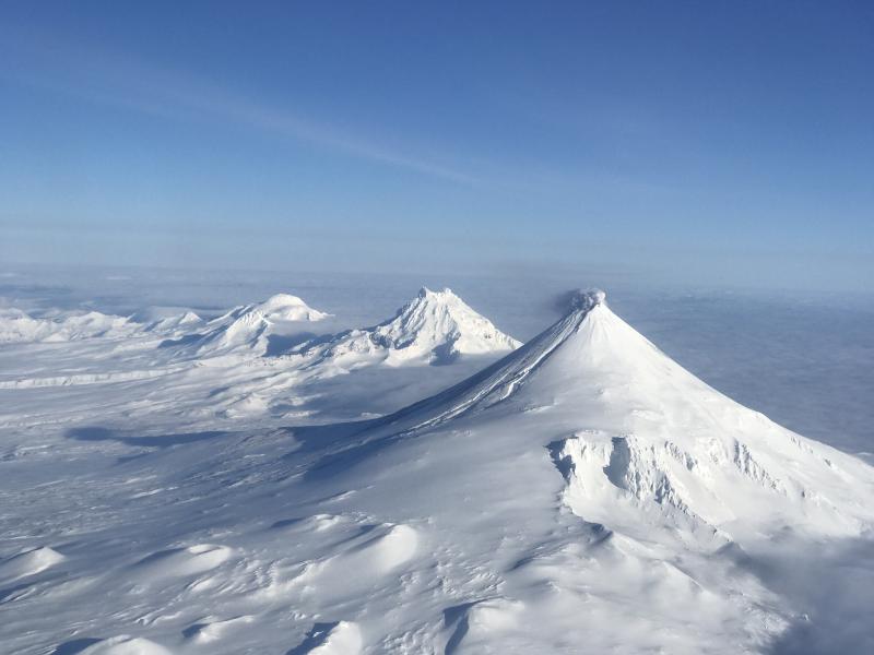
Alaska , Shishaldin :
54°45’19 » N 163°58’16 » W,
Summit Elevation 9373 ft (2857 m)
Current Volcano Alert Level: ADVISORY
Current Aviation Color Code: YELLOW
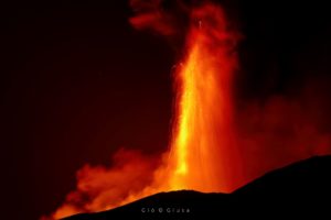
Shishaldin volcano February 22, 2020. Isanotski and Roundtop are visible in the distance.
Unrest continues at Shishaldin with indications of slightly elevated surface temperatures at the summit in satellite images and a visible steam plume in web camera images. Occasional periods of tremor and low frequency earthquakes were detected on the local seismic network, but no explosive activity was detected on regional infrasound sensors. Although unrest is currently at low levels, activity could escalate with little warning, and additional eruptive activity within the summit crater, lava flows, lahars, and ash-producing eruptive events could occur.
Shishaldin is monitored by local seismic and infrasound sensors, satellite data, web cameras, a telemetered geodetic network, and distant infrasound and lightning networks.
Source : AVO .
Photo : Jacob, Ben David.
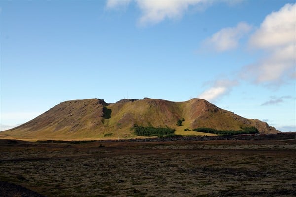
Iceland , Mont Thorbjorn :
Seismic activity around Mt. Þorbjörn has decreasing significantly
The area is now most likely recovering after the large induced stress
A Scientific Advisory Board met on 30th of April to discuss and review the current activity in Reykjanes Peninsula. The meeting was attended by scientists from the Icelandic Meteorological Office, University of Iceland – Earth Sciences and ÍSOR, and also representatives from the Civil Protection, ISAVIA-ANS and Police Dept of the South-Iceland.
In the beginning of April the uplift in Þorbjörn decreased and, in the second part of the month, it stopped.
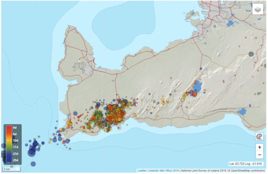
The photo shows an overview of seismic activity in April.
The area around Þorbjörn is now most likely recovering after the large induced stress, and the injected magma is cooling down and contracting. Along with reduced deformation, seismic activity has decreasing significantly. These data indicate that the injection of magma beneath Þorbjörn has stopped and this second phase of uplift due to magma intrusion can be considered closed. Even though there are no observations of ongoing uplift around Þorbjörn, there are indications of minor deformation over a larger area. The current observations and the course of events over the last several months suggest that there is an active long-term process ongoing in the area. The possibility of renewed activity in the near future at Þorbjörn, Reykjanes or elsewhere on the Reykjanes Peninsula cannot be discarded.
It is still important to keep in mind the seismic hazard is present in the Reykjanes Peninsula and it is important to take preventive measures.
The best way to prevent damage or injuries is to properly handle furniture and other interior objects so that they do not fall off in the event of an earthquake. The effects of an earthquake on the Reykjanes Peninsula, can be felt in a large area, and the capital area is not excluded.
The Scientific Advisory Board, therefore, encourages people to check with their home and workplaces and fix unstable hanging objects. Information on earthquake prevention and response can be found on the Civil Protection website.
Source : Vedur Is.
Photos : Vedur , Visit Reykjanes.
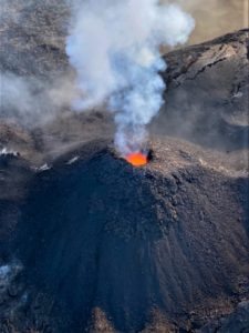
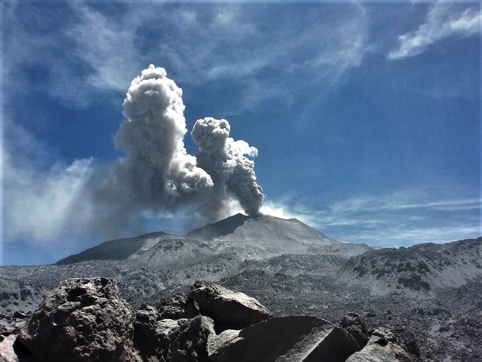
Peru , Sabancaya :
Analysis period: April 27 to May 3, 2020
Alert level: orange
Conclusion:
The Peruvian Geophysical Institute (IGP) reports that the eruptive activity of the Sabancaya volcano remains at moderate levels; that is to say with the continuous recording of explosions with columns up to 2.5 km high above the summit of the volcano and consequent emissions of ash and gas. Consequently, for the following days, no significant change is expected regarding its activity.
Recommendations:
• Maintenance of the orange volcanic alert level.
• Do not approach within a radius of less than 12 km from the crater. Cover your nose and mouth with cloths or wet masks if you fall ashes. Keep the doors and windows of houses closed.
• Implement prevention and mitigation actions in the face of an increase in volcanic activity.
• Stay informed at all times of the volcanic activity of Sabancaya through the bulletins published by the IGP.
• In the event of rain, it is recommended that the population stay away from the banks of the rivers flowing from the Sabancaya and Hualca Hualca due to the likely descent of lahars or mudslides.
Outlook:
• On May 4, the ash is dispersed towards the Southeast sector of the volcano. Between May 5 and May 10, the ash will be dispersed towards the east and southeast sectors of the volcano. Given the recording of volcanic explosions, the ash would be dispersed towards the south-east of the volcano at speeds of up to 60 km / h.
• Between 5 and 8 May 2020, precipitation and snowfall are expected in the area of the Sabancaya volcano, a period during which the lahars can flow towards the Colca valley.
Source : IGP.
Photo : ingemmet.
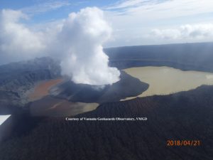
Indonesia , Semeru :
VOLCANO OBSERVATORY NOTICE FOR AVIATION – VONA .
Issued : May 04 , 2020
Volcano: Semeru (263300)
Current Aviation Colour Code: ORANGE
Previous Aviation Colour Code: orange
Source: Semeru Volcano Observatory
Notice Number: 2020SMR40
Volcano Location: S 08 deg 06 min 29 sec E 112 deg 55 min 12 sec
Area: East java, Indonesia
Summit Elevation: 11763 FT (3676 M)
Volcanic Activity Summary:
Eruption with volcanic ash cloud at 23h00 UTC (06h00 local).
Volcanic Cloud Height:
Best estimate of ash-cloud top is around 13043 FT (4076 M) above sea level, may be higher than what can be observed clearly. Source of height data: ground observer.
Other Volcanic Cloud Information:
Ash cloud moving to north
Remarks:
Seismic activity is characterized by eruption, avalanche and gas emission earthquakes
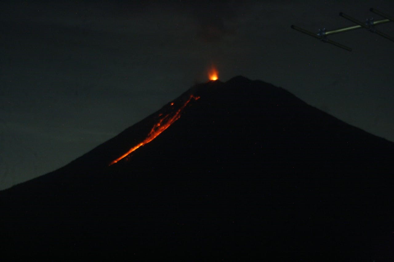
Level of activity at level II (WASPADA). The Semeru volcano (3676 m above sea level) is experiencing a continuous eruption. There are explosive and effusive eruptions, causing lava flows to the south and southeast slopes, as well as projections of incandescent rocks around the summit crater.
The volcano is clearly visible until it is covered with fog. 6 eruptions were observed with a column of smoke rising approximately 400-500 meters above the summit. The color of the smoke is white with a thick intensity dissipating towards the north. Observation of 2 hot clouds up to ± 500-1000 meters towards Besuk Kembar (the center of the flow is about 1000 meters from the crater). The weather is sunny to cloudy, the wind is light to the North, North-East, East and West.
According to seismographs, on May 4, 2020, it was recorded:
81 eruption / explosion earthquakes
2 avalanche earthquakes
5 emission earthquakes.
2 distant tectonic earthquakes.
Recommendation:
The community must not carry out activities within a radius of 1 km and in the area up to 4 km in the South-South-East slope sector of the active crater which is an opening area of the active crater of G. Semeru (Jongring Seloko) as a channel for sliding warm clouds.
Be aware of the presence of the lava dome in the Seloko Jongring crater.
Source : Magma Indonésie , PVMBG.
Photo : PVMBG.