April 15 , 2020.
La Réunion , Piton de la Fournaise :
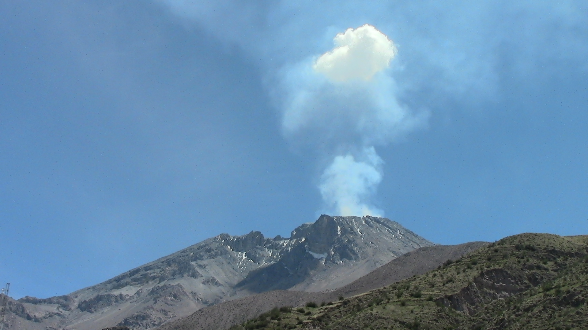
In its daily bulletin, the Piton de la Fournaise Volcanological Observatory (OVPF) noted a resumption of inflation (swelling) in the summit area. « The GPS in the summit area recorded an inflation, witnessing the pressurization of a surface and deep source » indicates the bulletin of this Tuesday, April 14, 2020.
« For two days, a resumption of inflation and a significant presence of CO2 have been noted » said Aline Peltier, director of the OVPF. This means that the magma is still present and going up. « This is something that has been regularly observed at the end of each eruption in 2018 and 2019, » says the volcanologist. A medium-term eruption is therefore likely.
Deformations
– The GPS of the summit area records an inflation, witnessing the pressurization of a surface source.
– The GPS in the far field records an inflation, witnessing the pressurization of a deep source.
Geochemistry
CO2 emissions from the soil increasing in the distal zone (Plaine des Cafres) and in the proximal zone (Gite du Volcan).
Source : IPReunion, OVPF.
Photo : rb/www.ipreunion.com.
Read the article : http://www.ipreunion.com/volcan/reportage/2020/04/14/volcan-volcan,117570.html
Italy / Sicily , Etna :
Weekly bulletin from 06/04/2020 to 12/04/2020 (date of issue 14/04/2020)
SUMMARY OF ACTIVITY STATUS
In light of the monitoring data, it is highlighted:
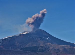
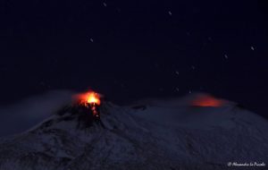
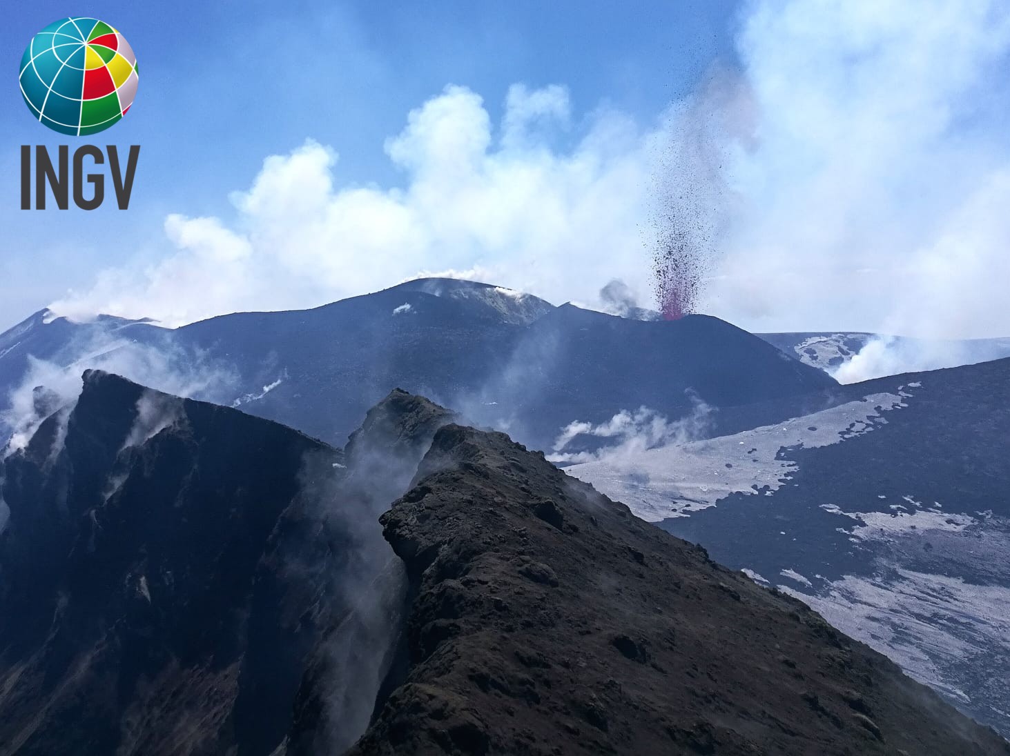
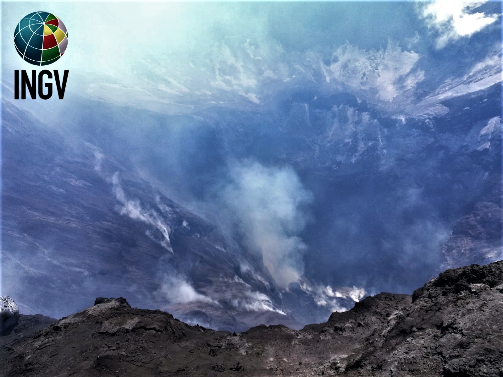
1) VOLCANOLOGICAL OBSERVATIONS: Strombolian and effusive intra-crater activity of the Voragine crater. Strong degassing of the New Southeast Crater and the Northeast Crater.
2) SEISMOLOGY: Low seismic fracturing activity, amplitude of the tremor at high levels.
3) INFRASONS: Modest activity.
4) DEFORMATIONS: No significant change takes place in the state of soil deformations on Etna.
5) GEOCHEMISTRY: the flow of SO2 is at a medium-low level. Soil CO2 flow values are low to medium. The partial pressure of dissolved CO2 does not show significant variations. The isotopic ratio of helium is fixed at medium-high values (last update of 2/14/2020). No update is available for the C / S report
6) SATELLITE OBSERVATIONS: The thermal activity in the summit area is low.
Strombolian explosion of the largest of the three cones growing inside in the Voragine crater of Etna, April 10, 2020. The view is oriented from the North-East Crater, the western edge of which is seen in the foreground . Photo by Francesco Ciancitto, INGV-Etneo Observatory.
VOLCANOLOGICAL OBSERVATIONS
During the week, monitoring of Etna activity was carried out using the INGV surveillance cameras – Catania Section (INGV-OE) and by means of an inspection in the area training carried out by INGV – OE staff on April 10.
The activity inside the Voragine crater continued with slight fluctuations, which have continued for 7 months. This activity consists of Strombolian explosions from three mouths, which build cones of slag intracrater, and of effusive activity, mainly from a mouth placed on the southern flank of the largest cone. The explosive activity was more continuous in the larger cone, the one that formed as the first, from September 12, 2019, and on April 9 and 10, strong explosions widened its mouth. On April 11 and 12, some explosions produced small bursts of ash that quickly dispersed into the atmosphere in the immediate vicinity of the summit craters.
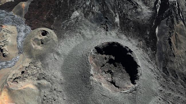
The interior of the northeast crater of Etna, April 10, 2020. At the bottom of the crater, there is an open degassing mouth, which during the visit to the site emitted continuous and loud roars, proof of activity explosive inside the duct. Photo by Francesco Ciancitto, INGV-Etneo Observatory.
During the inspection on April 10, an intense and noisy degassing activity was observed from an open mouth at the bottom of the northeast crater, without emission of pyroclastic material. In addition, during the week in question, two mouths on the « saddle cone » (a building with several mouths formed in spring 2017 in the area of the old saddle between the two cones of the New Southeast Crater and « Vecchio ») produced a strong pulsed degassing, sometimes accompanied by modest amounts of ash. At night, fluctuating lights were visible in the same mouths
Source : INGV.
Read the article : file:///C:/Users/Utilisateur/AppData/Local/Packages/Microsoft.MicrosoftEdge_8wekyb3d8bbwe/TempState/Downloads/BollettinoEtna20200414%20(1).pdf.
Photos : Francesco Ciancitto, INGV-Observatoire Etnéen
Italy , Stromboli :
Weekly bulletin from 06/04/2020 to 12/04/2020 (date of issue 14/04/2020)
SUMMARY OF ACTIVITY STATUS
In light of the monitoring data, it is highlighted:
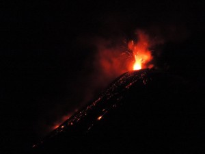
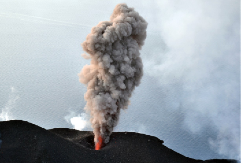
1) VOLCANOLOGICAL OBSERVATIONS: During this period, normal Strombolian type explosive activity was observed, accompanied by degassing and splashing activities. The hourly frequency of explosions fluctuated between medium-low values (9 events / h on April 6) and medium-high values (19 events / h on April 12). The intensity of the explosions was mainly medium-low in the area of the North crater and medium-high in the area of the Center-South crater.
2) SEISMOLOGY: The seismological parameters do not show significant variations.
4) DEFORMATIONS: No significant variation is observed in soil deformations
5) GEOCHEMISTRY: the flow of SO2 is at a medium-high level. The last measurement of the CO2 / SO2 ratio is at an average value (last update on 02/09/2020). The isotopic ratio of helium remains on average values (last update of 09/03/2020). There is no update on the CO2 released by the soil.
6) SATELLITE OBSERVATIONS: The thermal activity in the upper zone is of medium-low level.
VOLCANOLOGICAL OBSERVATIONS.
The analysis of the images recorded by the cameras placed at an altitude of 400m, at an altitude of 190m and at Punta dei Corvi made it possible to characterize the eruptive activity of Stromboli. During the period under review, the explosive activity was mainly produced by at least 4 (four) eruptive vents located in the area of the North crater and by at least 3 (three) eruptive vents located in the area of the Center-South crater . All the vents are located inside the depression which occupies the crater terrace. Due to a technical error, images from the video surveillance system were absent between 4:44 PM UTC on April 7 and 09:24 UTC on April 8.
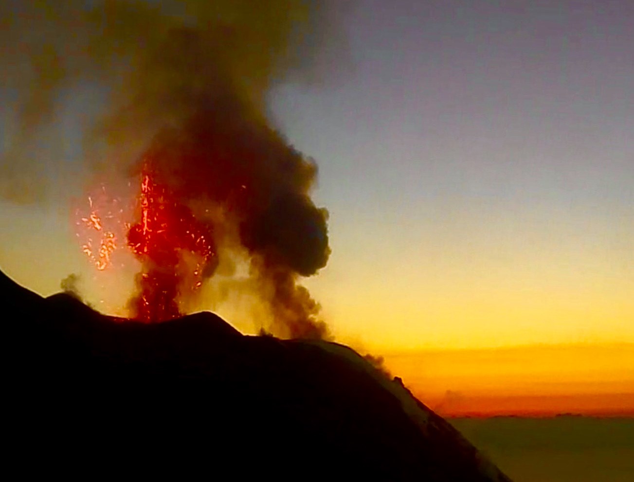
In the North zone, the explosions were mainly of variable intensity, from low (less than 80 m in height) to high (more than 150 m in height) emitting coarse materials (lapilli and bombs). In numerous explosions, the abundant fallout covered the outer slopes of the area overlooking the Sciara del fuoco and the blocks rolled until they reached the coast. In addition, an occasional intense splash involved 2 (two) of the 4 (four) mouths. The average frequency of explosions in the North zone varied between 4 and 12 events / h. The explosive activity of the Center-South zone produced explosions of mainly fine materials (ashes) mixed with coarse materials, with an average intensity (less than 150 m high) sometimes high (the products exceeded 250 m high) . The frequency of explosions in the Center-South zone varied between 2 and 7 events / h.
Source : INGV Vulcani.
Read the article : file:///C:/Users/Utilisateur/AppData/Local/Packages/Microsoft.MicrosoftEdge_8wekyb3d8bbwe/TempState/Downloads/BollettinoStromboli20200414%20(1).pdf
Photos : INGV , Webcam .
Peru , Ubinas :
Analysis period: April 6 to 12, 2020. Arequipa, April 13, 2020.
Alert level: ORANGE
The Geophysical Institute of Peru (IGP) reports that the dynamic behavior of the Ubinas volcano remains at low levels. To date, the recording of earthquakes associated with the rise of magma to the surface is rare. There are light and sporadic emissions of bluish gases (of magmatic origin) and water vapor. According to this scenario, the possibility of the appearance of explosions and / or ash emissions is low.
Between April 6 and 12, the IGP recorded and analyzed a total of 40 seismic events associated with the dynamic behavior of the Ubinas volcano, with the predominance of seismic signals of the Volcano-Tectonic (VT) type, related to the fracturing of rocks inside the volcano. On average, 5 earthquakes were recorded per day with magnitudes below M1.5. The seismic activity linked to the rise of magma (hybrid type) decreased both in number of events (1 earthquake over the period) and in energy.
Surveillance cameras recorded light and sporadic emissions of volcanic gases and water vapor, with heights less than 400 m above the summit of the volcano. Monitoring the deformation of the volcanic structure does not record any significant anomalies. MIROVA satellite monitoring did not record any thermal anomalies.
Source : IGP .
Photo : Unknown author.
Indonesia , Lokon :
VOLCANO OBSERVATORY NOTICE FOR AVIATION – VONA.
Issued: 20200415/0629Z
Volcano: Lokon (266100)
Current Aviation Colour Code: YELLOW
Previous Aviation Colour Code: unassigned
Source: Lokon Volcano Observatory
Notice Number: 2020LOK01
Volcano Location: N 01 deg 21 min 29 sec E 124 deg 47 min 31 sec
Area: North Sulawesi, Indonesia
Summit Elevation: 5056 FT (1580 M)
Volcanic Activity Summary:
An increased in volcanic earthquakes in the past view days has been observed indicating an increased likelihood of an eruption
Volcanic Cloud Height:
ash-cloud has not been observed
Other Volcanic Cloud Information:
ash-cloud has not been observed
Remarks:
An increased in seismicity
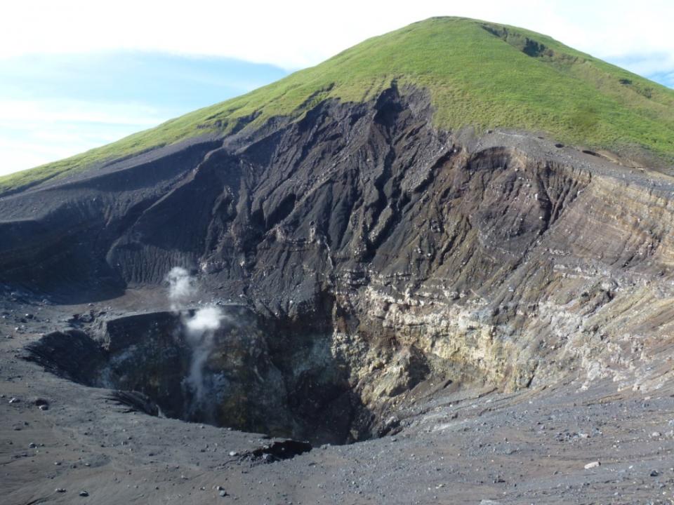
The twin volcanoes Lokon and Empung, rising about 800 m above the plain of Tondano, are among the most active volcanoes of Sulawesi. Lokon, the higher of the two peaks (whose summits are only 2 km apart), has a flat, craterless top. The morphologically younger Empung volcano to the NE has a 400-m-wide, 150-m-deep crater that erupted last in the 18th century, but all subsequent eruptions have originated from Tompaluan, a 150 x 250 m wide double crater situated in the saddle between the two peaks. Historical eruptions have primarily produced small-to-moderate ash plumes that have occasionally damaged croplands and houses, but lava-dome growth and pyroclastic flows have also occurred. A ridge extending WNW from Lokon includes Tatawiran and Tetempangan peak, 3 km away.
Source : Magma Indonésie , GVP.
Photo : Wikimapia .