January 21 , 2020 .
Alaska , Shishaldin :
VOLCANO OBSERVATORY NOTICE FOR AVIATION (VONA) .
Issued: January 20 , 2020.
Volcano: Shishaldin (VNUM #311360)
Current Color Code: ORANGE
Previous Color Code: RED
Source: Alaska Volcano Observatory
Notice Number: 2020/A63
Volcano Location: N 54 deg 45 min W 163 deg 58 min
Area: Aleutians
Summit Elevation: 9373 ft (2857 m)
Volcanic Activity Summary:
Ash emissions declined greatly at about 8:30 PM AKST (5:30 UTC 20 January). Seismicity is currently low. The Aviation Color Code is lowered to ORANGE and Alert Level to WATCH.
Satellite images show the detached volcanic cloud drifting east-southeast over the Pacific Ocean. A sigmet from the National Weather Service is still in effect for the detached cloud: https://www.weather.gov/aawu/sigmets
Low-level steam and ash emissions may be ongoing from the summit vent. It is possible for more significant eruption to resume with little warning.
Shishaldin is monitored by local seismic and infrasound sensors, satellite data, a web camera, a telemetered geodetic network, and distant infrasound and lightning networks.
Remarks:
Shishaldin volcano, located near the center of Unimak Island in the eastern Aleutian Islands, is a spectacular symmetric cone with a base diameter of approximately 16 km (10 mi). A 200-m-wide (660 ft) funnel-shaped summit crater typically emits a steam plume and occasional small amounts of ash. Shishaldin is one of the most active volcanoes in the Aleutian volcanic arc, with at least 54 episodes of unrest including over 24 confirmed eruptions since 1775. Most eruptions are relatively small, although the April-May 1999 event generated an ash column that reached 45,000 ft above sea level.
Next Notice:
A new VAN will be issued if conditions change significantly or alert levels are modified.
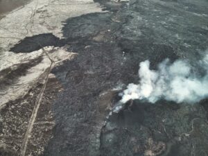
Seismicity decreased abruptly to low levels at about 3:30 PM yesterday afternoon, and ash production increased at about the same time, producing an ashy plume that reached to 30,000 ft. The eruption continued to produce ash until about 10 PM last night, when activity slowed. The Aviation Color Code and Alert Level were lowered to ORANGE/WATCH shortly after midnight, when it became clear that activity had waned and an ash cloud was no longer being produced. The ash cloud that had formed earlier continued to drift east-southeast overnight as it dissipated, but was still visible some 300 km (~185 miles) offshore this morning.
Elevated surface temperatures are still apparent in satellite images this morning. Webcam images captured after sunrise of the southeast side of the volcano show a weak steam plume at the summit, new tephra and (or) lava deposited on the upper flanks of the cone, and a dusting of ash on the snow across the entire area.
Source : AVO .
Photos : Woodsen Saunders , Savannah Yatchemeneff
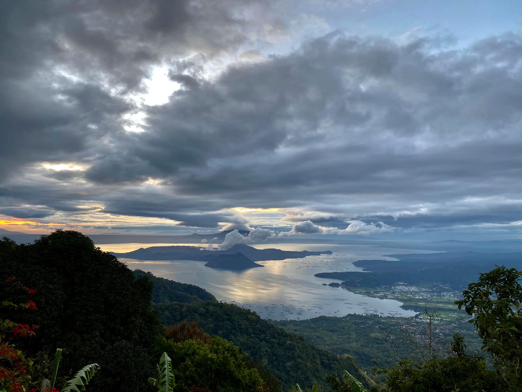
Philippines , Taal :
TAAL VOLCANO BULLETIN 20 January 2020 8:00 A.M.
Activity in the Main Crater in the past 24 hours has been characterized by steady steam emission and infrequent weak explosions that generated ash plumes 500 to 1000 meters tall and dispersed ash southwest of the Main Crater. Sulfur dioxide (SO2) emission was measured at an average of 4353 tonnes/day.
The Philippine Seismic Network (PSN) plotted a total of seven hundred fourteen (714) volcanic earthquakes since 1:00 PM, January 12, 2020. One hundred seventy-six (176) of these registered at magnitudes M1.2 – M4.1 and were felt at Intensities I – V. Since 5:00 AM on January 19, 2020 until 6:00 AM today, there were twenty-three (23) volcanic earthquakes plotted, registered at magnitudes M1.2-M3.8 with one (1) felt event at intensity I.
For the past 24 hours, the Taal Volcano Network, which can record small earthquakes undetectable by the PSN, recorded six hundred seventy-three (673) volcanic earthquakes including twelve (12) low-frequency earthquakes. Such intense seismic activity likely signifies continuous magmatic intrusion beneath the Taal edifice, which may lead to further eruptive activity.
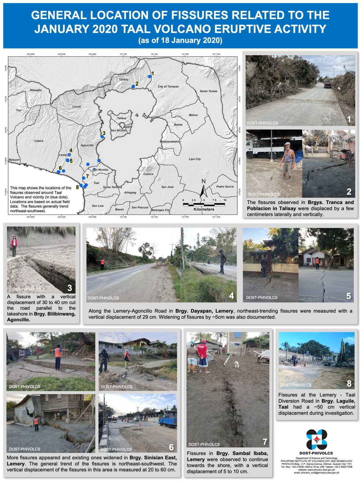
Alert Level 4 still remains in effect over Taal Volcano. This means that hazardous explosive eruption is possible within hours to days. DOST-PHIVOLCS strongly reiterates total evacuation of Taal Volcano Island and high-risk areas as identified in the hazard maps within the 14-km radius from Taal Main Crater and along the Pansipit River Valley where fissuring has been observed.

Based on PAGASA wind forecast, if the eruption plume remains below three (3) km, ash will be drifted to west and southwest of the Main Crater; if the eruption plume rises between three (3) to five (5) km ash will also be drifted to parts of Cavite province; however, if a major eruption occurs during the day and the eruption column exceeds 5 km, ash will also be drifted over Metro Manila, Laguna, and some parts of Rizal and Northern Quezon. Residents around the volcano are advised to guard against the effects of heavy and prolonged ashfall. Civil aviation authorities must advise pilots to avoid the airspace around Taal Volcano as airborne ash and ballistic fragments from the eruption column pose hazards to aircraft.
DOST-PHIVOLCS is continually monitoring the eruption and will update all stakeholders of further developments.
Phivolcs: Taal recharging for ‘powerful eruption’
MANILA, Philippines — Taal Volcano is swelling, a portion has sunk and the entire volcano island has tilted slightly, indicating a “resupply” of magma or molten rock rising to the surface that presages a powerful eruption amid the ongoing lull.
This was according to the Philippine Institute of Volcanology and Seismology, whose official said Taal appeared to be “recharging.” Phivolcs has maintained Alert Level 4 meaning a destructive eruption is imminent within days or even hours.
“There is resupply of magma from below based on earthquakes and ground deformation,” Science Undersecretary and Phivolcs officer-in-charge Renato Solidum Jr. said.
Solidum also said the silent activity beneath Taal has significantly altered the landscape of the volcano island.
He said some parts of the northeastern portion of the volcano have sunk while the entire volcano has swelled.
“The island has slightly tilted while being pushed. Some portions in the northeastern side are sinking. Maybe the houses there are already under water,” Solidum said.
Phivolcs volcano monitoring and eruption prediction division chief Mariton Bornas said the ground around the volcano has swollen except in the northeastern part. Swelling of a volcano signals an accumulation of magma near the surface.
Even before its eruption on Jan. 12, Solidum said they had warned the public regarding the volcano island’s being a permanent danger zone.
“We have been warning for years that permanent settlement is prohibited on the island,” he said.
He again appealed to the public to stay away from the volcano’s 14-kilometer radius danger zone.
“If it reaches the crater, it could cause a strong explosion,” Solidum said, referring to the magma buildup. Alert Level 4 is the second highest of the five-step alert on Taal.
He said more than 600 volcanic tremors have been recorded since Sunday, signifying a continued rise of magma.
The Phivolcs chief also noted the high concentration of sulfur dioxide (SO2), which means that magma is actively degassing beneath Taal.
The SO2 was measured at 4,353 tons yesterday. SO2 is a major gas component of magma.
Source : Phivolcs . Helen Flores (The Philippine Star) – January 21, 2020 – 12:00am .
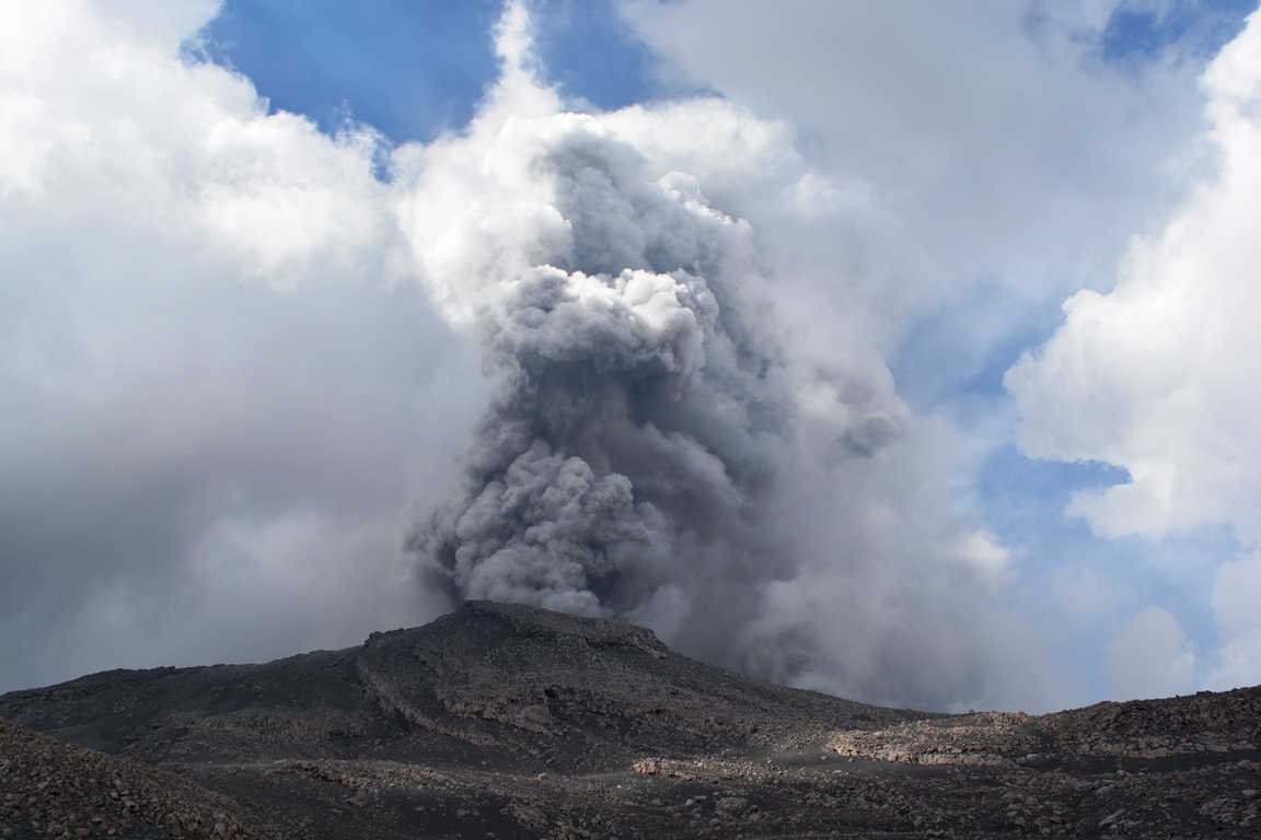
Indonesia , Semeru :
VOLCANO OBSERVATORY NOTICE FOR AVIATION – VONA .
Issued: January 19 , 2020.
Volcano: Semeru (263300)
Current Aviation Colour Code: ORANGE
Previous Aviation Colour Code: orange
Source: Semeru Volcano Observatory
Notice Number: 2020SMR03
Volcano Location: S 08 deg 06 min 29 sec E 112 deg 55 min 12 sec
Area: East java, Indonesia
Summit Elevation: 11763 FT (3676 M)
Volcanic Activity Summary:
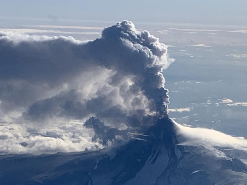
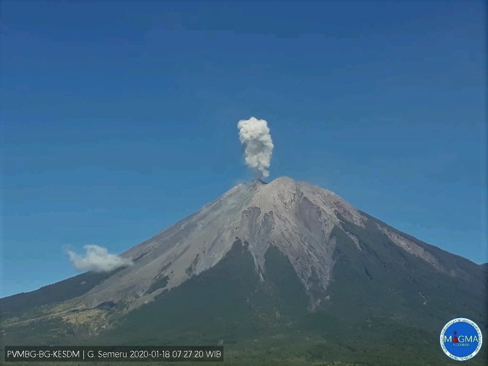
Eruption with volcanic ash cloud at 12h35 UTC (05h35 local).
Volcanic Cloud Height:
Best estimate of ash-cloud top is around 12723 FT (3976 M) above sea level, may be higher than what can be observed clearly. Source of height data: ground observer.
Other Volcanic Cloud Information:
Ash cloud moving to west
Remarks:
Seismic activity is characterized by eruption, avalanche and gas emission earthquakes.

Level of activity at level II (WASPADA). G. Semeru (3,676 m above sea level) is experiencing a continuous eruption. The last explosion occurred on January 19, 2020, causing an eruption column height of 400 m. The column is observed in gray color.
The volcano is clearly visible. The smoke from the crater is gray with moderate intensity, rising to about 400 meters above the summit. Sunny weather, light south wind.
According to seismographs on January 19, 2020, it was recorded:
29 éruption earthquake
3 avalanches earthquake
9 emissions earthquake
Recommendation:
(1). The community must not carry out activities within a radius of 1 km and in the area up to 4 km in the south-south-east slope sector of the active crater which is an active area of openings of the crater of G. Semeru (Jongring Seloko) as a channel for sliding warm clouds.
(2). Be aware of the presence of the lava dome in the Seloko Jongring crater.
VONA:
The last VONA code was sent with the color code ORANGE, published on January 18, 2020 at 05:12:00 WIB. Volcanic ash is observed at an altitude of 3976 m above sea level or about 300 m above the summit.
Source : Magma Indonésie , PVMBG .
Photos : PVMBG , Auteur Inconnu .
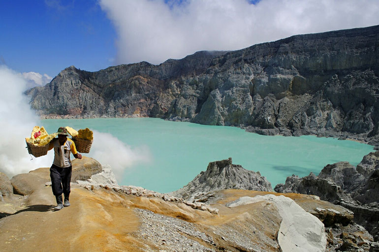
Indonesia , Ijen :
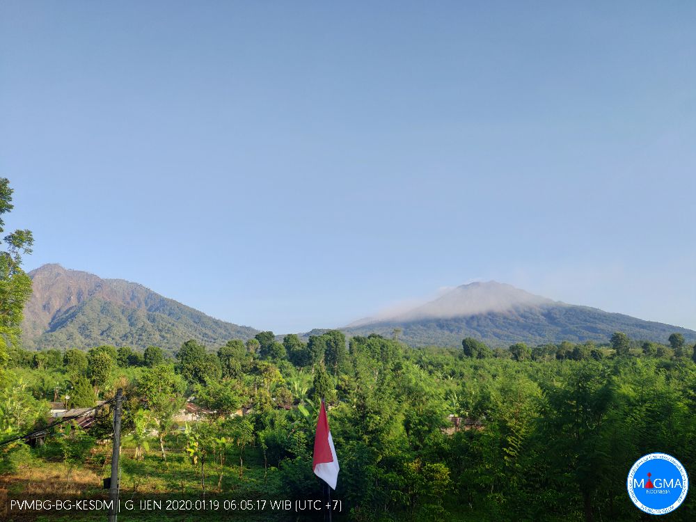
The G. Ijen or also called Ijen Crater is located in the region of Bondowoso Regency and Banyuwangi Regency, in the province of East Java. The Ijen crater has a height of 2145 m above sea level, while the highest point on the crater wall is 2386 m above sea level. An eruption of G. Ijen has was first recorded in 1796. The character of the G. Ijen eruption was phreatic and magmatic eruptions. The phreatic eruption occurs because the Ijen has a crater that allows direct or indirect contact between the water and the magma to form high pressure vapor which causes the eruption.
Between 1916 and 1994, there were a number of gas and phreatic eruptions. During the period 1999 to 2013, there was several times an increase in activity without any eruptions. The last increase in activity took place in February – March 2018, in the form of an increase in the water temperature of the crater lake followed by the appearance of gases remaining inside the crater lake.
The activity level of G. Ijen has been level I (Normal) since August 8, 2014.
Monitoring data:
Visually, during the period from January 1 to 18, white smoke of low to moderate intensity was observed about 50-200 meters above the summit or about 250-400 m above the surface of the lake. Observations to the crater lake did not show any change in the color of the lake, indicating an increase in sediment from the bottom of the crater to the surface due to high gas pressure.
Seismicity: the type of seismicity recorded during the period from January 1 to 18 was: emission earthquakes, non-harmonic earthquakes, tornillo-type earthquakes, shallow volcanic earthquakes, earthquakes deep volcanic, local tectonic earthquakes, distant tectonic earthquakes and a continuous tremor. There has been an increase in the number of shallow and volcanic earthquakes. Continuous tremors appeared since January 11, 2020 with a maximum amplitude of 7 mm on January 15, 2020, then decreasing on January 17 and 18, 2020.
The water temperature of the lake, the results of the measurement of the surface temperature of the crater lake from June 2019 to January 14, 2020 have fluctuated decreasingly. The highest temperature in June 2019 was 38 ° C and returned to 20.7 ° C on January 14, 2020. When activity increases in February – March 2018, the surface temperature of the water in the crater lake reaches 46 ° C.
Analysis:
The occurrence of shallow volcanic earthquakes (VB) indicates a process of fluid / gas movement at shallow depth (near the bottom of the lake) but their quantity is not too large.
It is also believed that the process of increasing the volume of water in the crater lake due to the current rainy season around the crater lake causes an imbalance in the water density of the crater at several different depths, from so that the gases which dissolve / accumulate in the deeper parts very easily manage to rise to the surface suddenly.
The process of the flow of these gases visually on the surface in the form of gas, is always done under low pressure.
An increase in the number of shallow volcanic earthquakes on January 17, 2020 indicates the presence of a supply of magma at a shallower depth.
Potential danger:
Under current conditions, the potential threat of volcanic activity from Mount Ijen is high concentrations of volcanic gases around the crater which can suddenly increase due to bursts of gas bubbles from the bottom of the lake.
Conclusion:
Based on the results of visual and instrumental observations until January 18, 2020, the level of volcanic activity of G. Ijen is still at level I (normal).
Recommendation:
The communities around G. Ijen and visitors / tourists / miners are not allowed to approach the edge of the crater or descend and approach the bottom of the crater at the top of G. Ijen and cannot stay overnight in the area of G. Ijen within a radius of 1 km around the crater.
Source : PVMBG .
Photos : PVMBG , Auteur Inconnu .
Peru , Sabancaya :
Analysis period: January 13-19, 2020. Arequipa, January 20, 2020.
Alert level: ORANGE
The Peruvian Geophysical Institute (IGP) reports that the eruptive activity of the Sabancaya volcano has been maintained at moderate levels; that is, with the continuous recording of moderate explosions and the resulting ash emissions. Consequently, for the following days, no significant change in activity is expected.
During the period from January 13 to 19, 2020, the IGP recorded and analyzed the occurrence of approximately 1076 earthquakes of volcanic origin, associated with the circulation of fluids (magma, gas, etc.) at the interior of the volcano. During this period, there were on average 7 daily explosions of medium to low intensity.
The monitoring of the deformation of the volcanic structure, using GNSS data (processed with fast orbits), does not record any significant anomalies. Visual surveillance, using surveillance cameras, allowed us to identify the presence of columns of gas and ash up to 2.6 km high above the summit of the volcano, which were scattered in the southern and Southwest of Sabancaya. Satellite surveillance made it possible to identify the presence of 2 thermal anomalies of values between 1 MW and 5 MW, associated with the presence of a lava dome in the crater of the volcano about 280 m in diameter. It should be noted that the number of anomalies has been reduced due to the high cloudiness in the region.
Source : Cenvul.
Photo : M. Rietze .