November 18 , 2019.
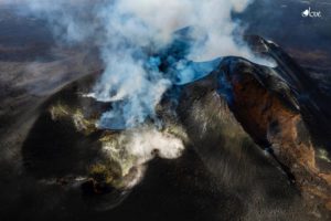
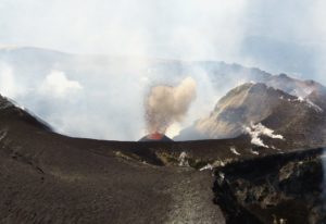
Japan , Shinmoedake :
Alert level raised for the volcano Shinmoedake in southwestern Japan
The alert level for a volcano in southwestern Japan was raised Monday amid increasing seismic activity in the area, according to the Japan Meteorological Agency.
With the level now at 2 on a 5-point scale, people were warned not to approach the crater of Mt. Shimmoe, a 1,421-meter volcano straddling Kagoshima and Miyazaki prefectures.
According to the agency, 22 earthquakes originating directly beneath the crater were observed between noon Sunday and 5 a.m. Monday.
The agency warned of potential eruptions and the risk of flying rocks within 2 kilometers of the crater, as well as pyroclastic flows within 1 km of the crater.
Mt. Shinmoe, which last erupted in June last year, is one of 50 constantly monitored active volcanoes in Japan.
Source : KYODO NEWS .
Photo : S. Nakano 08.03.2011 / Geological survey of Japan.
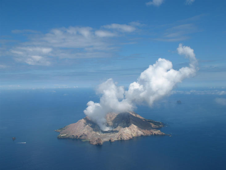
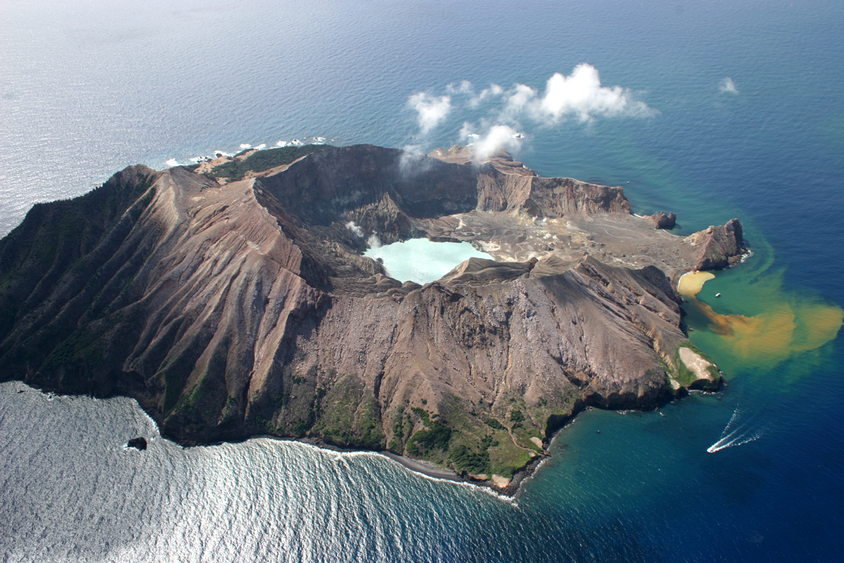
New Zealand , White Island :
Whakaari/White Island: Background activity increases further .Published: Mon Nov 18 2019 12:00 PM
Volcanic Alert BulletinWI – 2019/09
Volcanic Alert Level is raised to 2
Aviation Colour Code is raised to Yellow
Volcanic unrest continues at Whakaari/White Island and some monitored parameters show further increases in activity. Hazards on the island are now greater than during the past few weeks, and the Volcanic Alert Level is raised to Level 2.
Over the last several weeks, we have observed an increase in the amount of SO2 gas output. The SO2 gas originates from magma (molten rocks) at depth and the longer-term data from the past few months suggests a possible increase in gas passing through the volcano from depth.
In the past few weeks, the level of volcanic tremor has also increased from weak to moderate strength. Volcanic tremor can occur for many reasons, including the movement of gas through the volcano, changes in the geothermal system, and even surface activity (e.g. geysering). The number or locations of earthquakes beneath or near the island have not changed.
The crater lake level has been rising slowly since early-August and weak geysering-type activity has been observed at the edge of the lake around the active vents on the west side of the crater floor.
Other recent measurements made on the island (gas flow through the ground, fumarole and water chemistry, ground deformation, magnetics, visual images from the web cameras, and earthquake activity) show no significant changes. Changes in volcano monitoring parameters like these are common and can be explained by a range of processes occurring inside the volcano and near the surface. Uncertainty about the exact meaning of these changes often arises from the range of possible processes.
Overall, the monitored parameters are just above the expected range for minor volcanic unrest and associated hazards. The patterns of signals are similar to those through the 2011—2016 period and suggest that Whakaari/White Island may be entering a period where eruptive activity is more likely than normal, recent observations can also be explained by the increased gas flux which leads to geysering and lake level changes.
GNS Science and the National Geohazards Monitoring Centre continues to closely monitor Whakaari/White Island for further signs of activity. Volcanic Alert Level 2 is mostly associated with unrest hazards on the volcano and could include eruptions of steam, gas, mud and rocks. These eruptions can occur with little or no warning.
GNS Science volcanologists are monitoring the volcano and further information will be released as soon as it is available.
Source : Geonet /Michael Rosenberg / Duty Volcanologist.
Photos : Geonet ; rfleming .
Guatemala , Fuego :
LOW LAHAR IN THE CENIZA RAVINE.
Type of activity: Vulcanian
Morphology: Composite stratovolcano
Geographical location: 14 ° 28’54˝Latitude N; 90 ° 52’54˝Longitude O.
Height: 3,763msnm.
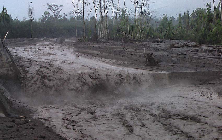
Precipitation recorded in recent hours in the Fuego Volcano region is now generating weak to moderate lahars in the Ceniza ravine.
These lahars have the following characteristics: they involve volcanic materials such as ashes, sand and blocks that vibrate the ground and generate sounds of rocky shocks. Trained equipment has been deposited by constant eruptive activity and it is expected that similar events will continue, the probability that they may increase and become stronger in their downstream descent should not be ruled out.
As the rains continue, the probability that lahars can be generated in any of the canyons of the Fuego volcano is not excluded.
Source : Insivumeh .
Alaska , Shishaldin :
54°45’19 » N 163°58’16 » W,
Summit Elevation 9373 ft (2857 m)
Current Volcano Alert Level: WATCH
Current Aviation Color Code: ORANGE
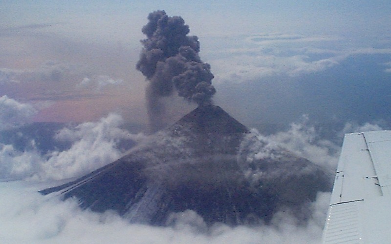
The low-level eruption at Shishaldin Volcano paused over the past day with low seismic tremor and only moderately elevated surface temperatures consistent with cooling lava flows. A small steam plume was present for most of the day and no ash plumes have been detected. Seismicity has started to increase this morning, which suggests that eruptive activity may be returning.
Shishaldin is monitored by local seismic and infrasound sensors, satellite data, a web camera, a telemetered geodetic network, and distant infrasound and lightning networks.
Source : AVO.
Photo : R. McGimsey , 23 avril 1999