August 22 , 2019.
Indonesia , Anak Krakatau :
Information on the eruption of G. Anak Krakatau, August 22, 2019.
Anak Krakatau, Lampung, was erupted on 22 August 2019 at 07:55 WIB. The height of the ash column was observed at ± 300 m above the summit (± 457 m above sea level). The column of ash was observed to be white, gray to black with a thick intensity oriented north and north-west. This eruption was recorded on a seismogram of maximum amplitude of 44 mm and a duration of ± 1 minute 47 seconds.
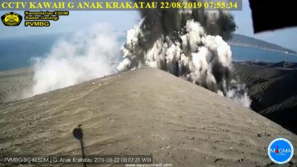
Currently, Anak Krakatau is at Alert Level II (Waspada) with recommendations: people / tourists are not allowed to approach the crater within 2 km.
VOLCANO OBSERVATORY NOTICE FOR AVIATION – VONA.
Issued: August 22 , 2019
Volcano: Anak Krakatau (262000)
Current Aviation Colour Code: ORANGE
Previous Aviation Colour Code: orange
Source: Anak Krakatau Volcano Observatory
Notice Number: 2019KRA148
Volcano Location: S 06 deg 06 min 07 sec E 105 deg 25 min 23 sec
Area: Lampung, Indonesia
Summit Elevation: 502 FT (157 M)
Volcanic Activity Summary:
Eruption with ash clouds at 00:55 UTC (07:55 local time). The eruption lasted for 107 seconds.
Volcanic Cloud Height:
Best estimate of ash-cloud top is around 1462 FT (457 M) above sea level, may be higher than what can be observed clearly. Source of height data: ground observer.
Other Volcanic Cloud Information:
Ash cloud is moving to North – North East
Remarks:
Eruption recorded on seismogram with maximum amplitude 44 mm and duration 107 second.
Sources : PVMBG , Magma Indonésie .
Photos : PVMBG , Yohannes Tyas Galih Jati , Mai 2019.
Tonga Islands , Unnamed volcano :
18.325°S, 174.365°W
Elevation -40 m
A submarine eruption in early August from an unnamed seamount about 50 km NW of Vava’u in Tonga created extensive areas of pumice rafts. Sailing crews encountered the pumice starting on 9 August about 40 km NNW of Late Island. Rachel Mackie described a pronounced odor of sulfur, and eventually being surrounded as far as she could see, with the surface pumice layer being 30 cm deep and containing pieces up to 80 cm in diameter.
https://www.facebook.com/rachel.mackie.718/videos/10157736969456019/
Sentinel-2 satellite imagery from 11 August showed the raft, averaging about 2.5 km across but strung out for 35 km NE-SW, located 70 km WNW of Late Island; another band of scattered rafts extended directly back from the main mass towards Late for 50 km. The raft continued drifting, and was at least another 60 km SW from its previous location as of 16 August. Eruptive activity at this location was previously reported in September-October 2001.
Sources: Sentinel Hub, Martin Jutzeler, Rachel Mackie.
Vidéo : Rachel Mackie via Sherine France.
Mexico , Popocatepetl :
August 21, 11:00 am (August 21, 16:00 GMT)
In the last 24 hours, 166 exhalations have been identified using the monitoring systems of the Popocatepetl volcano, accompanied by water vapor, gas and small amounts of ash. In addition, nine explosions were recorded yesterday. 608 minutes of Tremor and nine volcano-tectonic earthquakes were also recorded yesterday, with magnitudes ranging from M 1.8 to M 2.3.
During the night, the crater was partially observed an incandescence was observed.

Today in the morning and at the time of writing this report, we observe the volcano emitting steam, gas with a low ash content, that the winds are dispersed preferably towards the west.
CENAPRED urges NOT to approach the volcano and in particular the crater because of the risk of falling ballistic fragments, and in case of heavy rains to stay away from the bottom of the ravines due to the risk of mudslides and debris.
The warning light of Popocatépetl is in YELLOW PHASE 2.
Source : Cenapred.
Photo : GL.
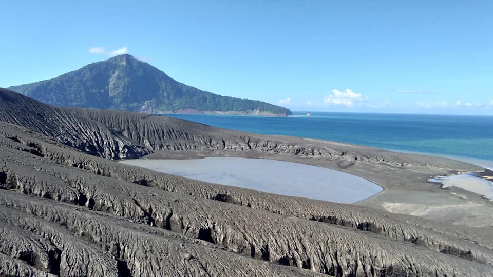
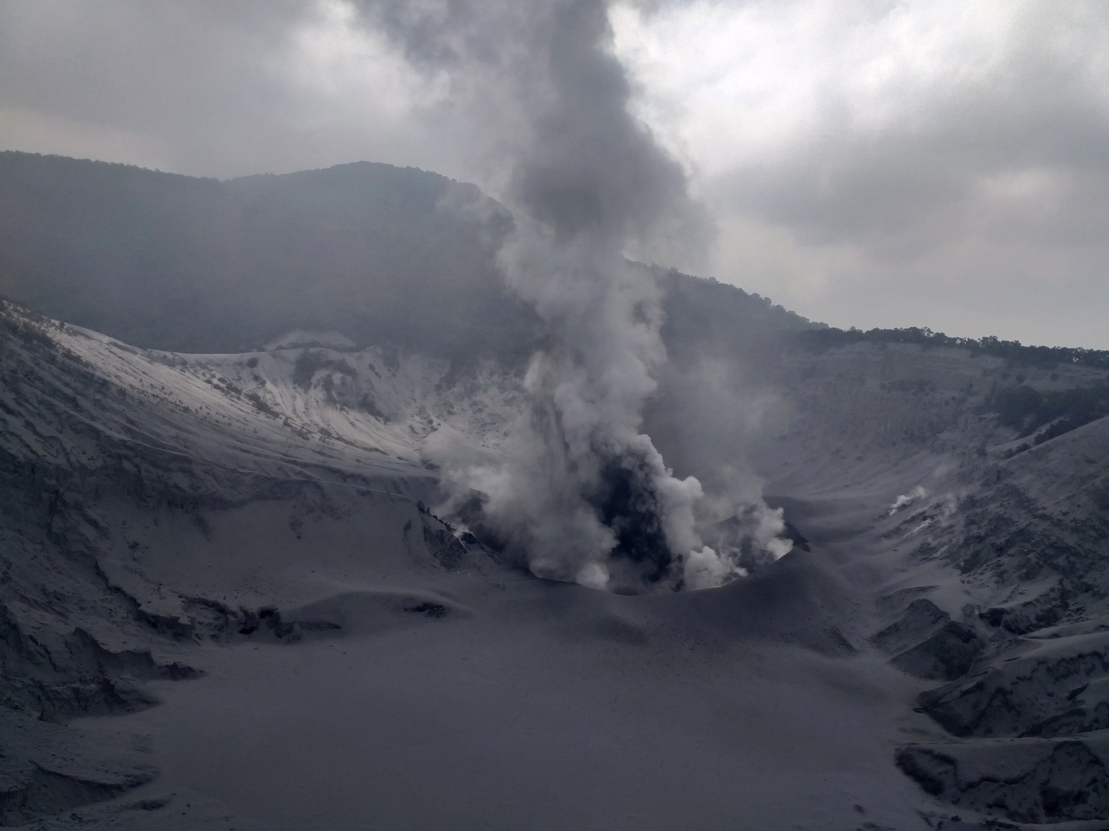
Indonesia , Tangkuban Parahu :
6.77°S, 107.6°E
Elevation 2084 m
PVMBG reported that during 12-18 August phreatic events at Tangkubanparahu’s Ratu Crater continued to produce sometimes dense gray-to-white plumes that rose as high as 200 m above the vent, and dense black ash plumes that rose as high as 100 m. The emissions were accompanied by roaring. Ashfall was localized around Ratu Crater. The seismic network recorded continuous tremor. The Alert Level remained at 2 (on a scale of 1-4), and the public was warned to stay 1.5 km away from the active crater.
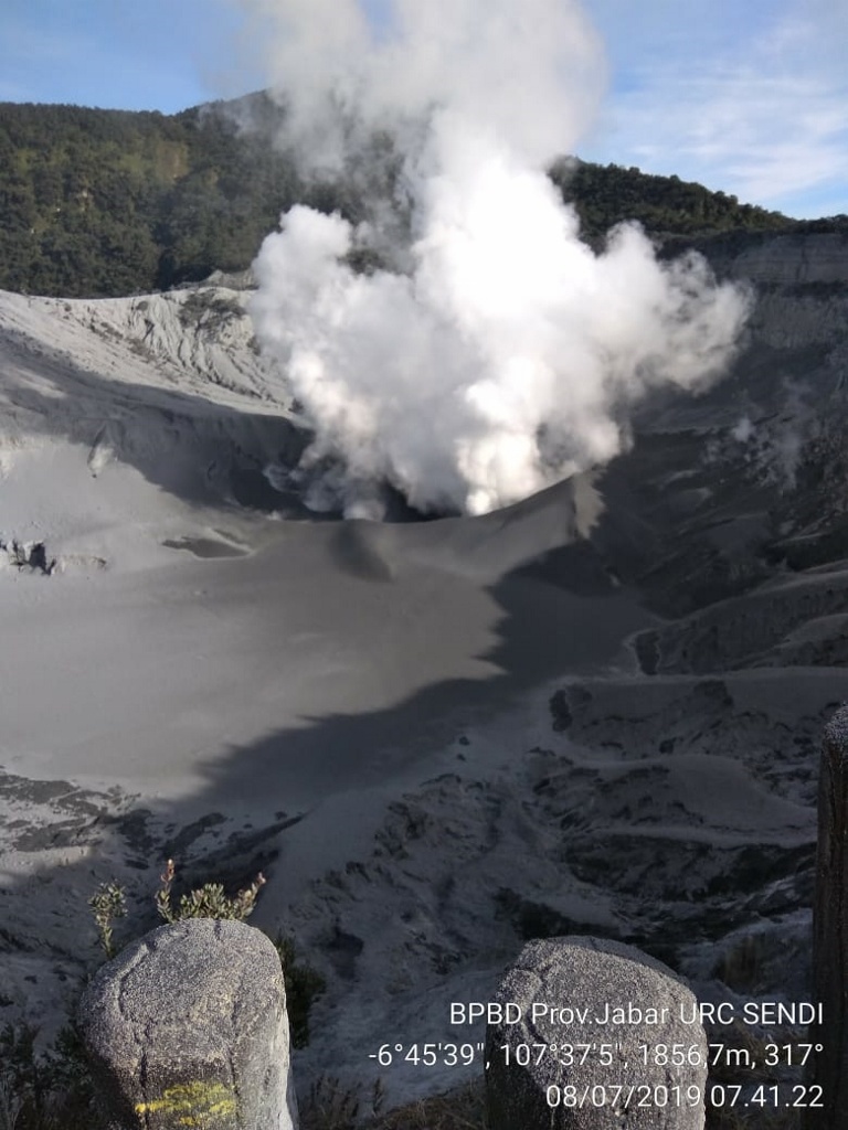
Level of activity at Level II (WASPADA). The Tangkuban Parahu (2084 m above sea level) erupted on July 26, 2019, at 15:48:18 West Indonesia time, with a column of ash rising to within ± 200 m. from the summit (± 2284 m above sea level). This was followed by an eruption on August 1, 2019, at 8:46 pm, western time of Indonesia, with the smoke column lying 180 m above the crater floor, followed by eruptions on 1 August. August 2, 2019 from 00:43 and 04:56 hours from western Indonesia.
Since yesterday and until this morning, the volcano was clearly visible until it was covered by fog. Smoke from the main crater is observed in white / gray with moderate to thick intensity.
The seismographs of August 21, 2019, recorded:
Tremor continuous with a dominant amplitude of 20 mm.
Recommendation:
– People around Mount Tangkuban Parahu and visitors / tourists / mountaineers should not approach the crater atop Mount Tangkuban Parahu within 1.5 km of the active crater. It is recommended to temporarily close the Tangkuban Parahu Nature Park for a greater safety distance.
VONA:
The last VONA code was sent with the color code ORANGE, published on August 1, 2019 at 4:20 am, western time of Indonesia, and related to the observations of volcanic ash emissions at 1:45 am, West time from Indonesia. With a height of ash column not observed.
Source: Pusat Vulkanologi dan Mitigasi Bencana Geologi , GVP.
Photos : BPBD .