February 07 , 2019.
Chile , Puyehue – Cordon Caulle :
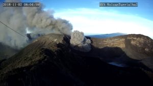
During the evaluated period, a total of 474 seismic events were recorded, of which 8 were classified as long-period type (LP), in relation to fluid dynamics within the volcanic edifice. The higher energy event had a reduced displacement value (DRc) equal to 0.2 cm2. Also, 466 volcano-tectonic earthquakes (VT), associated with rock fracturing processes, were recorded. The larger energy event had a local magnitude (ML) equal to M 2.8, and was located below the emission center of 2011, at a depth of 2.7 km.
The images provided by the IP cameras installed around the volcano do not show any superficial changes.
According to the data provided by three GNSS stations, it is observed that the inflationary process reported previously continues, with a slight decrease in its amplitude. The maximum horizontal variation rate recorded by the permanent network is 0.8 cm / month and the vertical rate of 0.9 cm / month for the station closest to the maximum deformation point located north-west of the center of issue of 2011. These sizes are considered important.
No sulfur dioxide (S02) emissions have been reported in the area near the volcanic building, according to data published by the Ozone Observatory Sulfur Dioxide Group (http: // mon2.gsfc.nasa.gov/). ) and the National Information and Satellite Data Service on the Environment (NESDIS) (http://satepsanoine.nesdis.noaa.gov).
No thermal warnings were reported in the area associated with the volcanic complex during the period, according to the data processed by the mean infrared observation of volcanic activity (MIROVA) (http://www.mirovaweb.it /) and the Temporal Thermal Monitoring of global hot spots (MODVOLC) (http://modis.higp.hawaii.edu/).
Apart from the amplitude of the inflation process, the seismicity remains at levels considered low and suggest a relative stability of the volcanic system.
Because of the above, the volcanic warning is kept at the level:
GREEN LEVEL: Changes in the behavior of volcanic activity – Probable time for an eruption: WEEKS / MONTH.
Source : Sernageomin.
Photo : Aquinohayplaya / Wikiloc.
Japan , Sakurajima ( Caldera of Aira ) :
31.593°N, 130.657°E
Elevation 1117 m
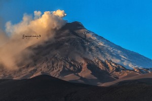
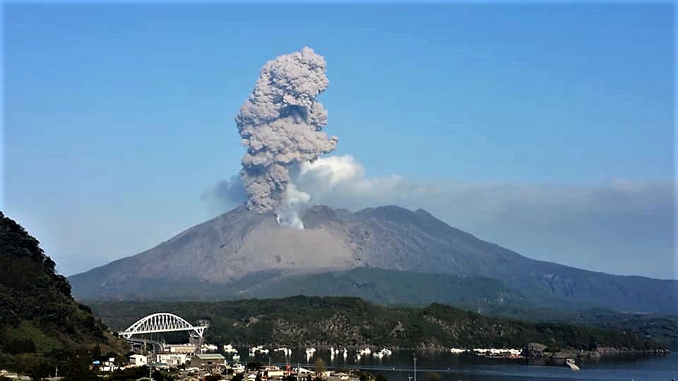
JMA reported that incandescence from Minamidake crater (at Aira Caldera’s Sakurajima volcano) was visible during 28 January-1 February. An explosion at 1400 on 1 February produced an ash plume that rose 600 m above the crater rim. During a field survey that same day the sulfur dioxide emission rate was high at 3,000 tons/day, an increase from the previous measurement of 1,800 tons/day recorded on 22 January. An explosion at 0228 on 3 February produced an ash plume that rose 1 km and ejected tephra 800-1,100 m from the crater. The Alert Level remained at 3 (on a 5-level scale).
The Aira caldera in the northern half of Kagoshima Bay contains the post-caldera Sakurajima volcano, one of Japan’s most active. Eruption of the voluminous Ito pyroclastic flow accompanied formation of the 17 x 23 km caldera about 22,000 years ago. The smaller Wakamiko caldera was formed during the early Holocene in the NE corner of the Aira caldera, along with several post-caldera cones. The construction of Sakurajima began about 13,000 years ago on the southern rim of Aira caldera and built an island that was finally joined to the Osumi Peninsula during the major explosive and effusive eruption of 1914. Activity at the Kitadake summit cone ended about 4850 years ago, after which eruptions took place at Minamidake. Frequent historical eruptions, recorded since the 8th century, have deposited ash on Kagoshima, one of Kyushu’s largest cities, located across Kagoshima Bay only 8 km from the summit. The largest historical eruption took place during 1471-76.
Source: Agence météorologique japonaise (JMA), GVP.
Photo : Auteur inconnu .
Indonesia , Karangetang :
Level of activity at Level III (SIAGA). G. Karangetang (2460 m altitude) has been reinstated since 25 November 2018.
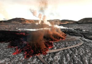
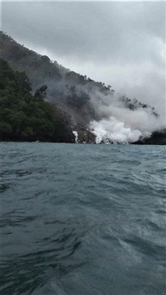
Since yesterday and until this morning, the volcano was clearly visible then covered with fog. Smoke from the main crater is not observed. The wind is weak in the northeast and southwest. A low to fairly loud roar was heard at the PGA station, which is more than 3,500 meters from the top of Crater II. At the end of the mud flow / lava mixture, evaporation resulted in a thick puff of white smoke. Avalanches on the edges of the lava body often occur, causing brown smoke, sometimes gray / blackish, thick. This time, the lava flow reached the sea.
The seismographs recorded on February 6, 2019:
46 avalanche earthquakes
76 earthquakes of explosion.
118 hybrid earthquakes
1 shallow volcanic earthquake.
1 deep volcanic earthquake.
4 distant tectonic earthquakes
Tremor continuous with an amplitude of 0.25 to 4 mm, and a dominant value 1 mm.
PVMBG reported that the current eruption at Karangetang began with increased seismicity and thermal anomalies in November 2018. Since then activity was dominated by lava-dome growth, avalanches, and pyroclastic flows. A gray ash plume rose above the summit craters on 30 January. By 2 February ’a’a lava from Kawah Dua (North Crater) had traveled 2.5 km NNW down the Melebuhe River drainage, prompting the evacuation of eight families (about 21 people). A section of the local road was closed, from W of the Batuare River to Kali Melebuhe. According to a news article the flow was 50 m thick in some areas. Seismic signals indicating avalanches sharply increased on 3 February. Lava and pyroclastic flows originated from the Kawah Dua crater, traveling as far as 1 km W down the Sumpihi River drainage, 2 km NW down the Batuare River, and 2.9 km NW down the Malebuhe drainage. BNPB reported that 112 residents (from Niambangeng, Kampung Beba, and Batubulan villages) had evacuated by 1730 on 4 February, and according to a news article the lava crossed the highway at 1800. The lava flow continued to progress and reached the ocean during 5-6 February.
Source : PVMBG , GVP.
Photos : Fad’G’ly Kyle Tahulending. Andi Rosadi / VolcanoDiscovery Indonesia.
Ecuador , Reventador :
0.077°S, 77.656°W
Elevation 3562 m
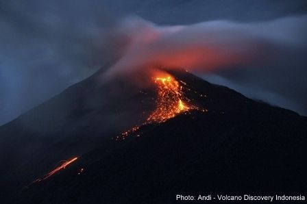
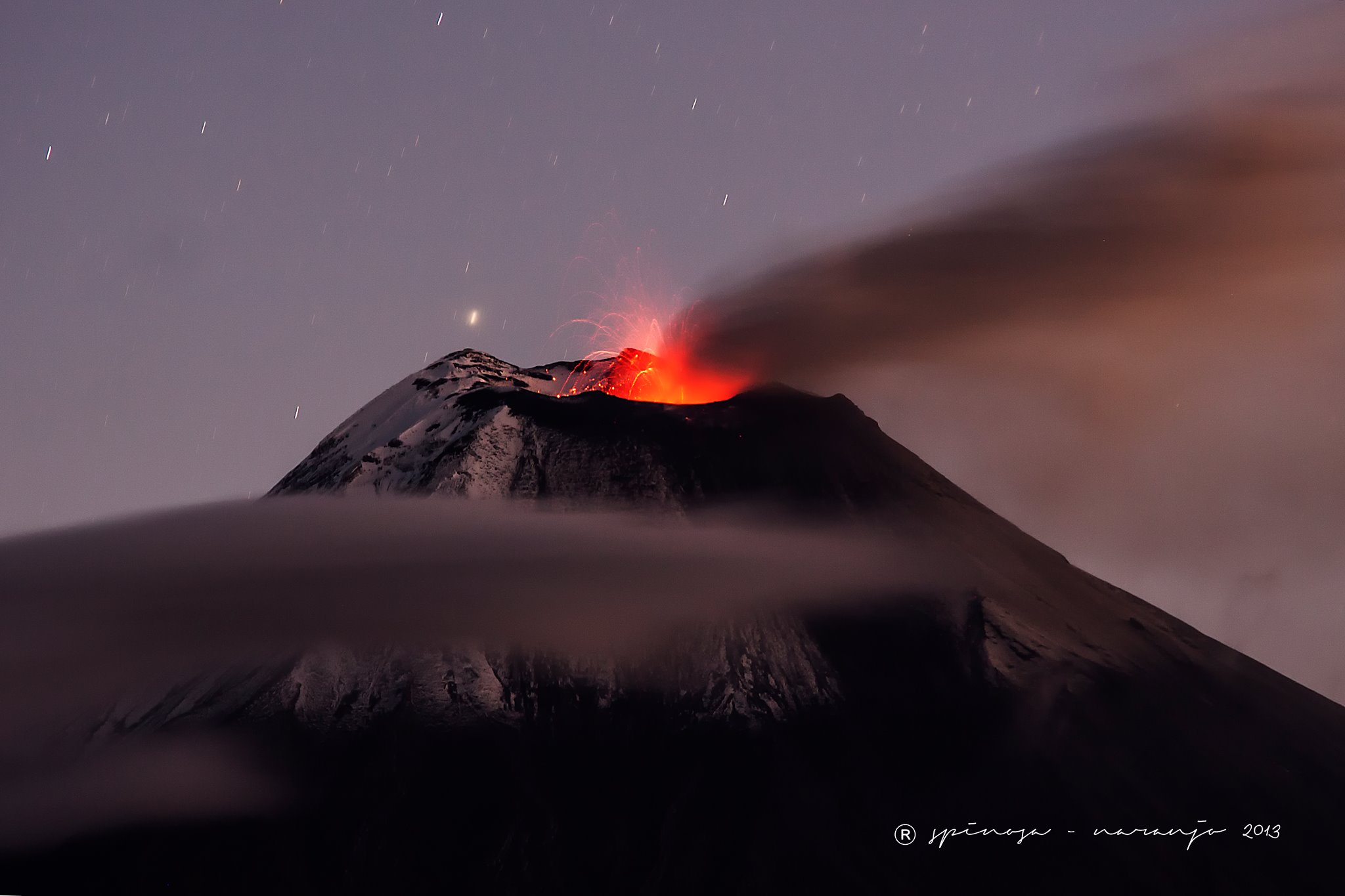
During 28 January-5 February IG reported a high level of seismic activity at Reventador, including explosions, long-period earthquakes, harmonic tremor, and signals indicating emissions. Steam, gas, and ash plumes sometimes rose as high as 1 km above the crater rim and drifted W and NW. Incandescent blocks were observed rolling 600-800 m down the flanks on most days.
Seismicity:
Long Period Type (LP): 40,
Explosions (EXP): 37,
Transmission Tremor (TE): 7,
Harmonic tremor (TA): 5
Gas flow (SO2) (tons / day): 301.0 +/- 43.0 Number of measures validated: 4
Rain / lahars: No rain has been reported in the area.
Ash Emission / Column: On the night of yesterday, steam, gas and ash emissions were observed at altitudes up to 800 meters above the summit in a northwesterly direction.
Other monitoring parameters: No change.
Observations: During the night, an incandescence was observed in the crater and blocks were rolled up to 800 meters under the summit of all sides of the volcano. Most of the time, the area remained cloudy.
Alert level: orange
Source: Instituto Geofísico-Escuela Politécnica Nacional (IG) , GVP.
Photo : J.L. Espinosa Naranjo .