December 30 , 2018.
France / Guadeloupe , La Soufrière :
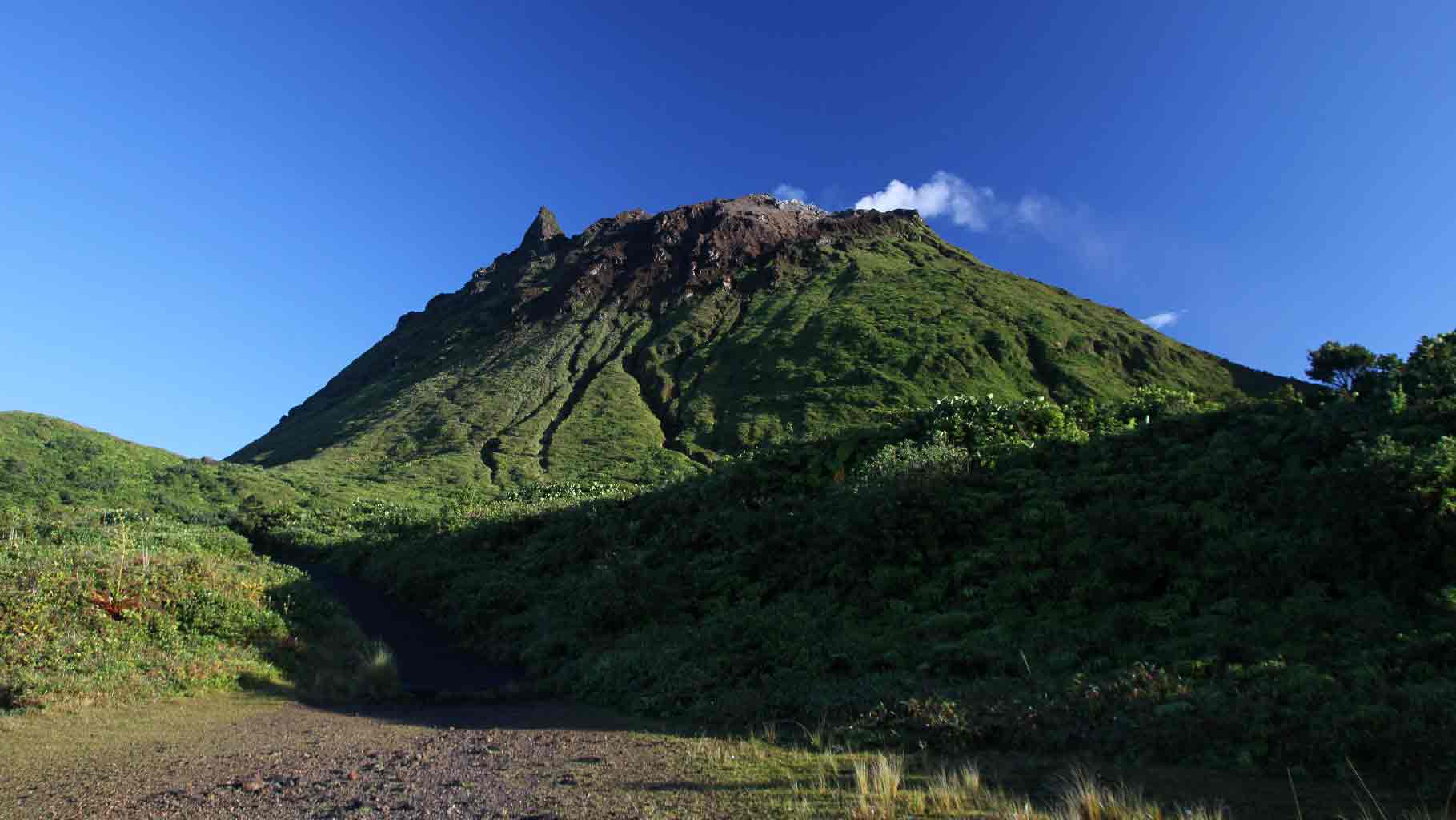
Volcanic activity of the Soufrière of Guadeloupe.
Soufrière de Guadeloupe is an explosive type active volcano that has experienced many magmatic and phreatic eruptions in the past. Since 1992, its seismic, fumarolic, thermal, and superficial deformation activity has followed a fluctuating but generally increasing regime, which results in a strong activity of the hydrothermal system (circulation and interactions of gas, steam and water in overpressure in the porous rock and fractured). Since the beginning of 2018, we have been witnessing a cyclic process of deep magmatic gas injection at the base of the hydrothermal system at a depth between 2 and 3 km below the summit.
This generates a recurring process of overheating and overpressure of the hydrothermal system which results in:
1) disturbances of the circulation of hydrothermal fluids;
2) the evolution of fumarole activity at the summit, one of which shows a projection of mud burning and acidic over a few meters;
3) an increase in volcanic seismicity in swarms;
4) some volcanic earthquakes felt (four between February and April 2018) including an earthquake of magnitude M4.1 on April 27, 2018, the strongest since 1976;
5) deformations of small amplitude and limited to the La Soufrière dome of the order of 3-7 mm / year and the continuation of the opening of the summit fractures;
6) fluctuation of the flow of fumarolic gas from a pressurized hydrothermal reservoir;
7) a progression of thermal anomalies in the soil at the top of La Soufrière. If these phenomena encourage the observatory to instrumental vigilance, they are currently not clearly associated with an anomaly of other monitoring parameters that could indicate a possible rise of magma. The latter would typically, but not always, be manifested by numerous deep and / or felt earthquakes, large-scale deformations beyond the dome, and the emission of sulfur gases at high temperatures (> 150 ° C).
On the basis of the OVSG-IPGP observations recorded during the month of November 2018 and summarized in this bulletin, and in accordance with the provisions laid down by the authorities, the level of volcanic alert remains at the level: VIGILANCE / YELLOW.
The probability of eruptive activity in the short term remains low. However, given the increase in seismic and fumarolic activity recorded since February 2018, a change of regime of the volcano has been observed such that we can not exclude an intensification of phenomena in the future. As a result, the OVSG-IPGP is in a state of heightened vigilance. The gaseous fumes in the vicinity and leeward of the main fumaroles of the summit (notably the Crater South, the Tarissan, and the Gouffre 1956) present, since 1998, proven risks of irritation and burns (eyes, skin, respiratory tracts) and burning mud and acid sludge. Due to the presence of these toxic gases, the municipal by-law of the city of Saint-Claude No. 01-296 of October 29, 2001, amended on January 27, 2015, prohibits public access to certain areas of the summit. Given the evolution described above and other observations on the activity, the OVSGIPGP considers it important to keep, as a precaution, a distance of at least 50 m radius around the main centers of emission of fumarolic gas (South South Crater, South Central Crater, North South Crater, North Napoleon, East Napoleon, Chasm 1956, Tarissan Chasm).
Source : OVSG-IPGP
Photo : P Giraud / ctig , aide-voyage.com.
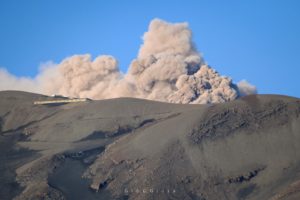
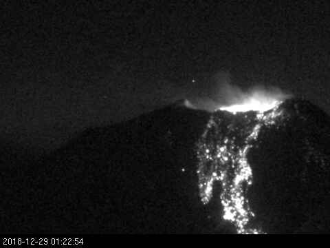
Chile , Nevados de Chillan :
Special Report on Volcanic Activity (REAV), Nuble Region, Nevados Volcano of Chillan, December 28, 2018, 23:00 Local Time (Continental Chile).
The National Geological and Mining Service of Chile (Sernageomin) publishes the following PRELIMINARY information, obtained from monitoring equipment of the National Volcanic Monitoring Network (NVRN), processed and analyzed at the Volcanological Observatory of the Southern Andes (OVDAS) :
Today, Friday 28 December 2018, at 22:11 local time (01:11 UTC 29 December), monitoring stations near the Nevados de Chillan volcanic complex recorded the occurrence of an explosive event, with an earthquake associated with fluid dynamics inside volcanic ducts (long period type).
The characteristics of the earthquake, after its analysis, are as follows:
TIME OF ORIGIN: 22h11 Local time (01h11 UTC)
LATITUDE: 36.863 ° S
LONGITUDE: 71.375 ° W
DEPTH: 1.0 KM
REDUCED MOVEMENT: 540 cm2
ACOUSTIC SIGNAL: 5 Pa reduced to 1 km.
OBSERVATIONS:
This explosion was associated with a seismic signal with a reduced displacement value considered strong. It has been possible to observe an incandescence associated with the emission of gases and pyroclasts at high temperature, those falling in an area near the active crater. The precedents allow to consider the partial destruction of the dome located inside the active crater. At present, no other abnormal signals have been recorded that could affect the internal dynamics of the volcano.
Volcanic technical alert level remains at level: ORANGE
Sernageomin continues online monitoring and will inform in a timely manner about any changes observed.
Source : Sernageomin.
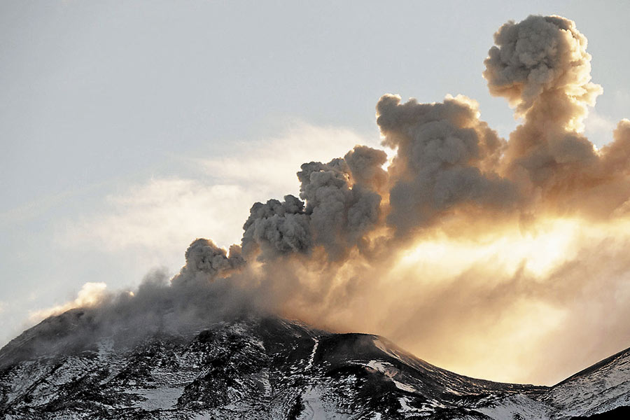
Italy / Sicily , Etna :
Preliminary map of the flank eruption of Etna from 24 to 27 December 2018, by Marco Neri.
The lava flow in the Bove Valley, generated by the mouths at the base of the new crater of the south-east to the effusive mouths lower than the eruptive fracture of December 24, seen from the south-east wall of the valley del Bove
Thanks to the logistic support of the 2nd Nucleo Aereo helicopter of the coastguard of Catania and the coordinated activities of the National Civil Defense, the flight of the Etnéen eruptive theater was carried out on December 26th, which made it possible to acquire equipment photographic and video with thermal camera. This documentation made it possible to identify and map the eruptive fissure, the ash cones aligned above it and the lava field of the eruption (Figure 1).
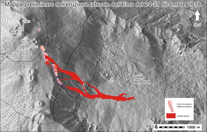
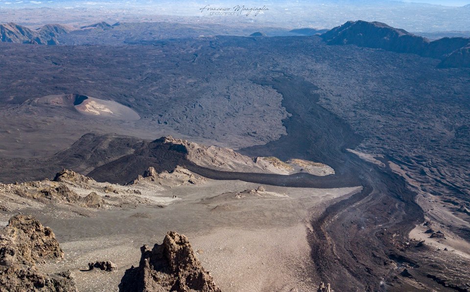
Figure 1 – Preliminary map of the products emitted during the eruption of December 24 to 27, 2018. The topographic base used was produced by the INGV TECHNOLAB section of the Catna Etna Observatory, laboratory for technological progress in geophysics of volcanoes. The abbreviations in the upper left corner identify the different craters of the summit (NEC = northeastern crater, VOR = voragine, BN = Bocca Nueva, SEC = southeastern crater, NSEC = new crater southeast).
The eruptive fissure consists of three segments: the northernmost is located just north of the New Southeast Crater, at about 3,100 meters above sea level. This fracture produced only modest Strombolian activity of a few tens of minutes. The intermediate segment is located in the NNO-SSE direction and is approximately 750 meters long; it lies between the lower eastern flank of the New Southeast Crater, at a little over 3,100 meters above sea level, and the edge of the Valle del Bove at around 2,875 meters (Figure 2). The lower segment of the crack enters Valle del Bove, crosses its west wall and stops at about 2,400 meters. It is about 1000 meters long, always located in the direction of NNO-SSE, but slightly moved eastward with respect to the segment described above.
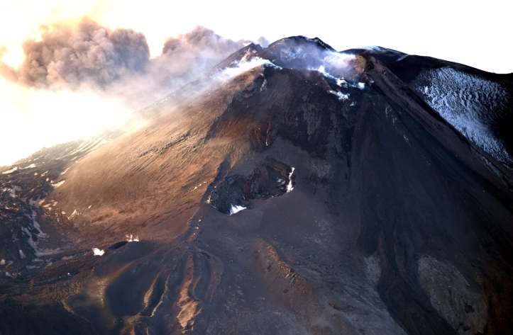
Figure 2 – The segment at a higher elevation of the eruptive fissure that opened on December 24, 2018 on the lower eastern flank of the New Southeast Crater. Photo of Marco Neri.
The area covered by the products of the eruption does not exceed 1 square kilometer. According to a very preliminary estimate, the average thickness of these products varies between 3 and 6 meters. Therefore, the total volume of the eruption is between 3 and 6 million cubic meters. On the evening of December 27, the most advanced lava front was very slow. However, the thermal camera surveys carried out by ING INOV researchers Luigi Lodato and Stefano Branca have verified the absence of food for eruptive mouths.
More detailed map processing and more accurate quantitative assessments will be available as soon as precision topographic data is acquired.
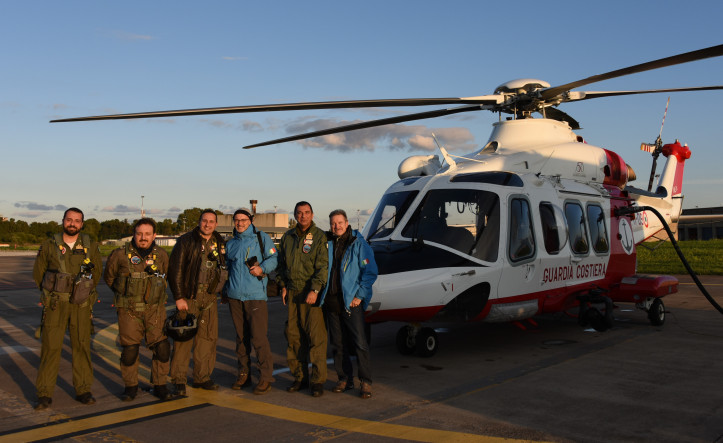
Figure 3 – Flight crew over the eruptive theater on the afternoon of December 26, 2018 using the helicopter provided by the coastguard of Catania. Stefano Branca and Marco Neri took part for INGV.
Source : Marco Neri / INGV Catane .
Read the article : https://ingvvulcani.wordpress.com/2018/12/29/mappa-preliminare-delleruzione-laterale-delletna-del-24-27-dicembre-2018/
Photos : Francesco Mangiaglia , Maco Neri / INGV Catania.
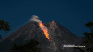
Indonesia , Agung :
Eruption of G. Agung Press release, December 30, 2018.
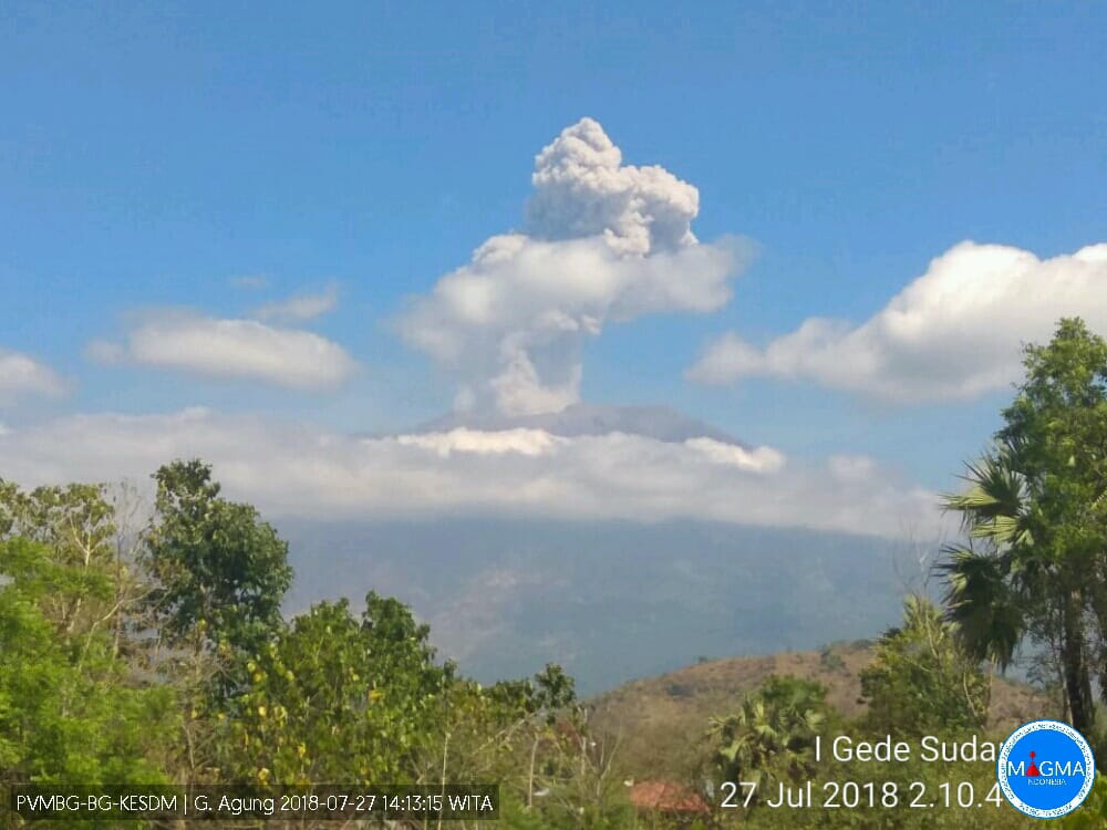
The Gunung Agung in Karangasem Regency, Bali again erupted on December 30, 2018 at 04:09 WITA for 3 minutes 8 seconds with an amplitude of 22 mm. The eruption is due to an « overpressure » due to the accumulation of volcanic gases. At the time of the eruption, incandescence was observed in the crater area, but the height of the ash column was not observed due to fog. According to the information collected by satellite, the volcanic ash is moving towards the South-East, reaching 5,500 m of altitude. Light ash rains were reported in the Karangasem regency, in the south-eastern sector of Mount Agung, as in the city of Amlapura and in several villages such as the villages of Seraya Barat, Seraya Tengah and Tenggalinggah.
Before this eruption, no significant increase in the intensity of seismicity was observed, but several volcanic earthquakes were recorded, including an earthquake on the northern slope of Mount Agung on December 28, 2018 of magnitude M2.7 to 2:49 WITA and M2.4 to 15:31 WITA. These earthquakes indicate the movement of magma towards the surface. Between 27 and 29 December 2018 (before the eruption), the MODIS satellites also showed no thermal anomaly on the surface of the Mount Agung crater, which did not indicate any fresh lava material on the surface of the crater.
Before today’s eruption, the Gunung Agung erupted on July 27, 2018. On July 29, 2018 at 06:47 WITA, the Lombok earthquake with a magnitude of 6.4 was accompanied by several replicas. A series of tectonic earthquakes around Lombok Island have affected the activity of Mount Agung, where shocks play a role in the release of volcanic gases on the surface in the form of blowing. Under these conditions, the accumulation of gas in the depth becomes disrupted, which decreases the potential for eruption. During the aftershocks of the Lombok earthquake, Mount Agung did not burst. But along with the reduction of tectonic earthquakes, the accumulation of volcanic gases in Mount Agung is possible. Over the past month, the earthquakes recorded on Mount Agung have been dominated by blowing earthquakes, tectonic earthquakes and several shallow and deep volcanic earthquakes.
Based on the overall data analysis, the potential for a larger eruption is still relatively low. Eruptions that may occur at this time may take the form of incandescent rock / lava flows, ash rains, or gusts of volcanic gas.
Until 30 December 2018 at noon , it can be concluded that the activity status of Mount Agung is still at level III (SIAGA) with a recommendation to estimate the danger zone in all areas within a radius. 4 km from the peak. The estimated danger zone is dynamic and continues to be evaluated. It can be modified at any time to follow the latest / most recent observation data from Mount Agung. Communities living and traveling around streams from Gunung Agung are sensitized to the potential secondary hazard in the form of rainwater lava flows that can occur especially during the rainy season and if the eruption material is still exposed in the peak area. The area of the rainwater lava follows the rivers upstream of Mount Agung.
The public is encouraged to remain calm while remaining ready by following the evolution of Mount Agung’s activities via the MAGMA Indonesia website (https://magma.vsi.esdm.go.id) and via the MAGMA Android application. Indonesia, downloadable from the Google Play Store.
Source : PVMBG
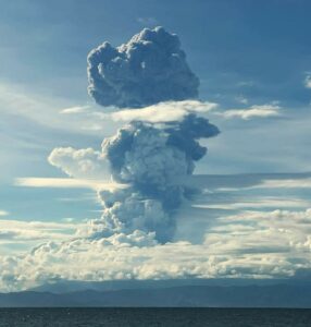
Kamchatka , Sheveluch :
VOLCANO OBSERVATORY NOTICE FOR AVIATION (VONA)
Issued: December 30 , 2018
Volcano:Sheveluch (CAVW #300270)
Current aviation colour code:ORANGE
Previous aviation colour code:red
Source:KVERT
Notice Number:2018-136
Volcano Location:N 56 deg 38 min E 161 deg 18 min
Area:Kamchatka, Russia
Summit Elevation:10768.24 ft (3283 m), the dome elevation ~8200 ft (2500 m)
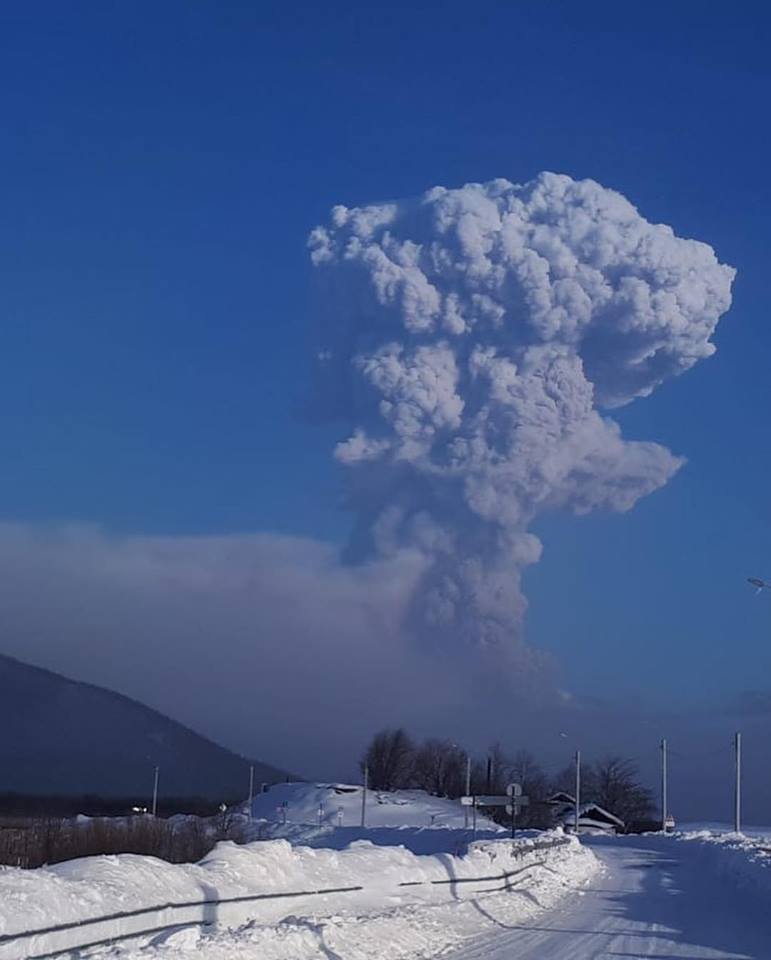
Volcanic Activity Summary:
An eruptive activity of the volcano continues. Satellite data by KVERT showed the ash plume on the height 5-6 km a.s.l. continues to drift for about 245 km to the south-west and later west from the volcano.
A moderate gas-steam activity of the volcano continues. Ash explosions up to 32,800-49,200 ft (10-15 km) a.s.l. could occur at any time. Ongoing activity could affect international and low-flying aircrafts.
Volcanic cloud height:
16400-19680 ft (5000-6000 m) AMSL Time and method of ash plume/cloud height determination: 20181230/0540Z – Himawari-8
Other volcanic cloud information:
Distance of ash plume/cloud of the volcano: 152 mi (245 km)
Direction of drift of ash plume/cloud of the volcano: WSW / azimuth 257 deg
Time and method of ash plume/cloud determination: 20181230/0540Z – Himawari-8
Source : Kvert.
Photo : Кирилл Баканов