December 18 , 2018.
Vanuatu , Ambrym :
AMBRYM VOLCANO ALERT BULLETIN No10 issued by the Vanuatu Meteorology and Geohazards Department on 17th November 2018 at 22:36 PM:
Eruptive activity at Ambrym is continuing in the minor eruption state. The Volcanic Alert Level remains at Level 3.
The volcanic eruption at Ambrym is continuing in the minor eruption. The Danger Zone for life safety is now limited at the Danger Zone B which is about 2 km around Benbow and 4 km around Marum craters (including Maben-Mbwelesu, Niri-Mbwelesu and Mbwelesu) (See Safety Map below). The additional area of risk is within 3 km from major cracks in the south east of Ambrym.
Observations and seismic data analysis in 16th and 17th December 2018 confirm an ongoing emission of ash or/and gas column from eruptive vents from Benbow and Marum craters and ongoing localized earthquake activity in the south eastern part of Ambrym. This earthquake activity is related to the current volcano eruption. People from Ambrym and neighboring islands will continue to experience volcanic ashfalls and feel earthquakes. These may cause cracks on buildings and land in some areas, especially in the South East Ambrym area.
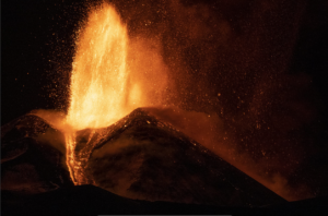
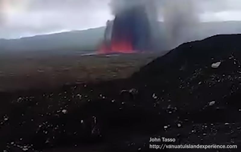
A small fissure eruption began inside the volcano’s caldera near the base of Marum cone on Saturday (15 Dec) morning at around 06:00 local time.
Our trusted local guide John arrived first on the scene a few hours after the start of the eruption and observed a approx. 100 m long erupting curtain of fire (several lava fountains arranged closely spaced along a fissure) to a height of approx. 40 m, producing a lava flow and a small steam and ash plume.
The lava flows are spreading towards the eastern part of the caldera but are not expected to reach much more than one or two kilometers in length as the size of the eruption is considered small (so far).
However, if lava flows continue and find a way outside the caldera, they could threaten villages on the eastern slopes and coast.
Source : Geohazard. Volcanodiscovery ( https://www.volcanodiscovery.com/ambrym/news/72344/Ambrym-volcano-Vanuatu-new-eruption-in-caldera-as-curtain-of-fire-erupts-from-fissure-at-base-of-Mar.html )
Photo : John Tasso.
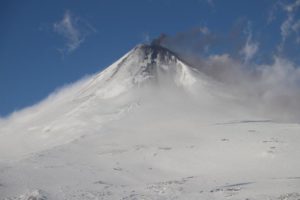
Peru , Sabancaya :
An average of 18 EXP / day was recorded. The activity associated with fluid movements (long period type) continues to predominate. Earthquakes associated with the rise of magma (hybrid types) remain very few and low energy.
The columns of gas and eruptive ash reached a maximum height of 2200 m above the crater. The dispersion of these materials occurred within a radius of about 40 km, mainly to the western and southwestern sectors.

On December 13, the volcanic gas (SO2) flow recorded a maximum value of 3,100 tonnes / day, a value considered important.
The deformation of the surface of the volcanic building does not represent any significant changes.
The MIROVA satellite system recorded 5 thermal anomalies, with values between 2 MW and 18 MW VRP (Radiated Volcano Energy).
In general, eruptive activity maintains moderate levels. No significant changes are expected in the coming days.
Source : IGP.
Photo : unknown
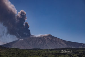
Ecuador , Sangay :
Special information on the Sangay volcano N ° 3 – 2018.
End of the eruptive phase
Summary:
The last eruptive phase of the Sangay volcano, which began on August 8, 2018 (Special Report No. 1), ended on December 7, after 4 months of continuous activity. The main phenomena associated with this period were: the emission of lava flows on the East-South-East flank and ash columns directed mainly towards the West. These volcanic phenomena had no major effect on the population because their products were limited to the vicinity of the volcano; with the exception of a slight ashfall in the city of Guayaquil, reported on 18 September, which did not cause any damage.

Visual observations and surface activity:
The most significant surface activity during this period was the emission of volcanic ash columns (Figure 1a) of about 920 ± 450 meters above crater level, which sometimes exceeded 2 km (Figure 2a). ). The ash clouds were mainly directed to the west and northwest of the volcano, this wind direction being predominant (Special Report No. 2). During this period, VAAC Washington reported 164 alerts due to ash columns. On 18 September, a slight ash drop was reported at Guayaquil, which did not cause any inconvenience.
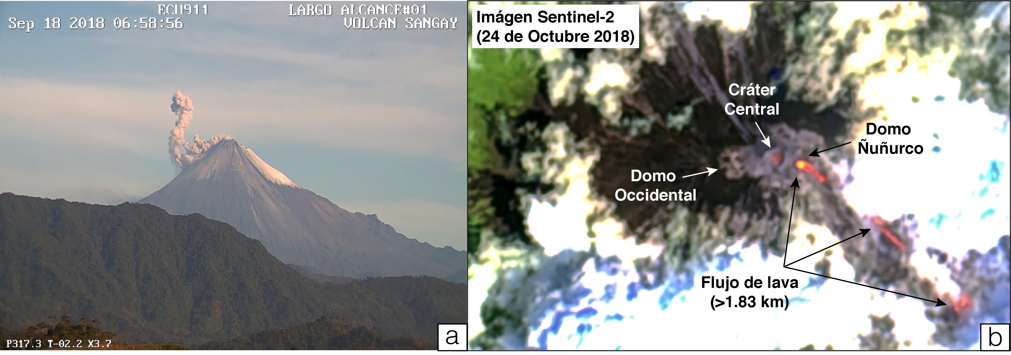
Figure 1. a) Photograph of the surface activity of the Sangay volcano. Emission of ash column about 1 km to the west (September 18). Courtesy ECU-911. b) Satellite image (false color) taken by the Sentinel 2 sensor, October 24, 2018. The Ñuñurco dome is seen from which flows the lava flow that extends over the south-east flank for more than 1 , 8 km before disappearing under the clouds. It also shows the central crater that showed explosive activity.
In addition, the continuous emission of lava flows was recorded from a lateral vent on the east-southeast flank of the volcano (dome Ñuñurco). The lava flows fell between 1 and 2 km below the level of the crater (Figure 1b), while the phenomena associated with its location, such as: the rolling of blocks and the possible generation of small pyroclastic flows due to the collapse of the lava front reached distances up to 7 km below the crater level, according to the thermal information recorded by the MIROVA satellite system. Figure 2b shows the temporal evolution of the thermal warnings reported by the MODVOLC satellite system related to the explosions and the emission of lava flows for the eruptive period from August to December 2018 on the Sangay volcano.

Figure 2. a) Maximum height of ash columns from Sangay volcano recorded by Washington VAAC at crater level, b) Thermal anomalies recorded by the MODVOLC satellite system for the period August to December 2018. Data available at address: https: //www.ssd.noaa.gov/VAAC/messages.html and http://modis.higp.hawaii.edu/ respectively.
Seismic / acoustic activity:
Figure 3 shows the seismic activity of the Sangay volcano from November to December 2018. There were between 25 and 88 explosions / day with an average value of 60 (red bars). Since December 2, seismicity has decreased considerably, reaching a daily average of 2 to 5 events, 10 times less than previously. On December 7th, the last two explosions of this phase are recorded. In addition, other events related to fluid movements (LP types) and rock fracturing (VT types), as well as seismic movements related to the location of lava flows (tremors) have decreased.
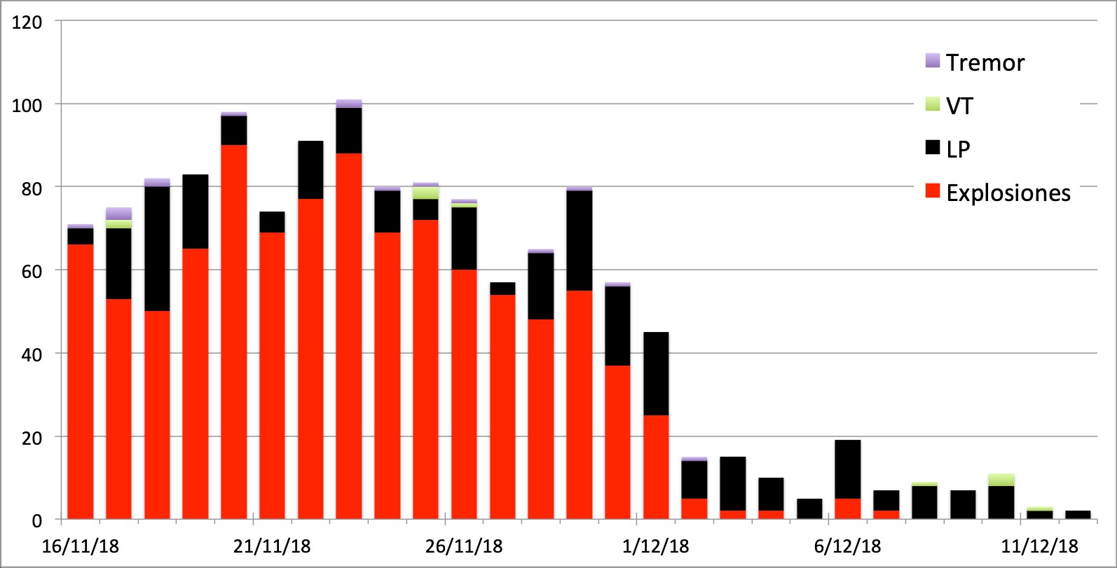
Figure 3. Bar chart showing the number of seismic events recorded by the SAGA station from November to December on the Sangay volcano. No registration is available until November 16th due to technical issues at the station.
Interpretation:
Since activity levels have decreased considerably on the surface (thermal warnings and ash plumes) and internally (number of seismic events), the IG-EPN indicates that the eruptive phase of the Sangay volcano ended after 121 days of continuous activity, being the longest since the beginning of the cyclical behavior of the volcano in 2015 (for more details, special report n ° 2).
The Institute of Geophysics of the National Polytechnic School monitors the Sangay Volcano and informs of any recorded changes.
Source : IGEPN
Photo : Morona Santiago.
Iceland , Bárðarbunga :
Earthquake near Bárðarbunga Volcano yesterday Morning .
17 DECEMBER 2018. Just before seven o’clock this morning, a powerful earthquake was recorded at Bárðarbunga volcano in Vatnajökull National Park.
The Icelandic Meteorological Office has reported that there are no signs of post-tremor activity, nor of an upcoming eruption. The earthquake measured 3.6 on the Richter scale.
Vatnajökull National Park is named after its most prominent glacier, known to conceal a litany of mountains, valleys and volcanoes beneath its 400–900 metres thick ice sheet.

Bárðarbunga is the largest volcano found beneath the glacial ice, whilst Grímsvötn is its most active. Most recently, Bárðarbunga has become famed as a photography hot spot, with photographers travelling from across the world to snapshot its spewing lava.
Earthquakes are a fairly common occurrence in Iceland given the fluctuating nature of its geological makeup. This makeup is comprised of moving tectonic plates, shifting ice sheets and geothermal energy.
The Icelandic Meteorological Office is currently monitoring the situation, though for now, the situation appears to have calmed down.
Source : Guide to Iceland .
Photo : johann k johansson