November 25 , 2018.
Indonesia , Merapi :
ACTIVITY REPORT OF MERAPI VOLCANO , November 16-22, 1818
I. RESULTS OF OBSERVATION
Visual:
The weather is sunny in the morning and afternoon, the foggy evening. The observed smoke is white, thick, with low gas pressure. The maximum height of 125 m is observed from the observation post of Mount Merapi at Babadan on November 16, 2018.
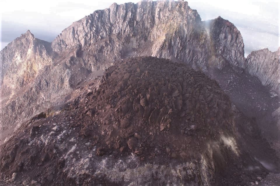
Dome of lava and morphology of the peak:
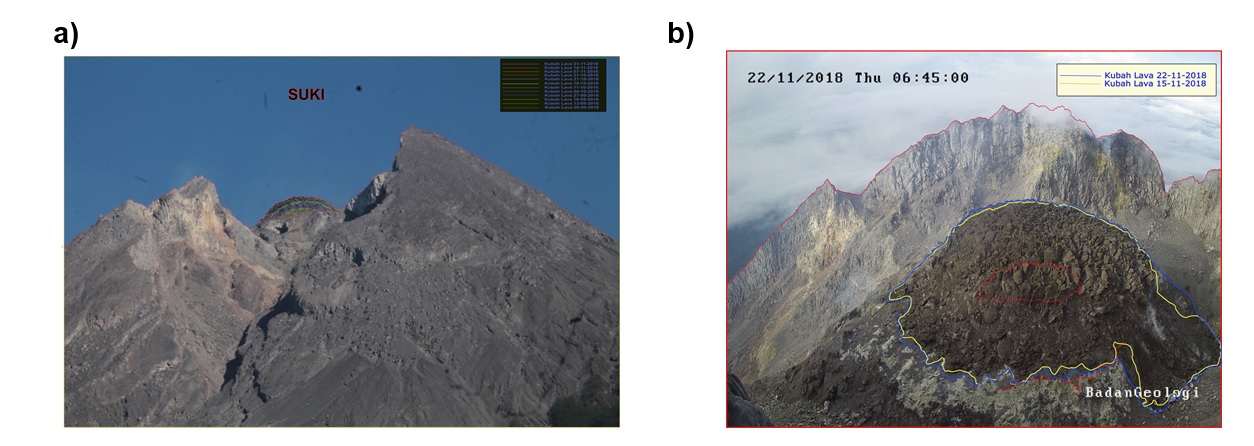
Morphological analysis based on photos from the Southeast sector showed morphological changes in the form of dome growth. Appendix 1.a presents the advanced morphological analysis performed by the Deles Camera Station.
The volume of the lava dome on November 21, 2018 was 308,000 m3 with an average growth rate of 2,600 m3 / day, slightly higher than the previous week. Currently, the lava dome is still stable with a low growth rate (<20,000 m3 / day). Annex 1.b presents an analysis of the lava domes of the Puncak camera station.
Seismicity:
This week, Mount Merapi seismicity recorded 28 emission earthquakes (DGs), 2 shallow volcanic earthquakes (VTB), 2 multi-phase earthquakes (MPs), 261 avalanche events (RF), 21 low frequency earthquakes (LF) and 4 tectonic earthquakes (TT). This week’s seismic intensity is lower than the previous week.
Deformation:
The deformation of G. Merapi controlled by EDM and GPS this week did not show any significant change. Annex 1.c points to the deformation graph in Merapi G.
SO2 emissions:
During this week, the DOAS (Differential Optical Absorption Spectroscopy) measurement gave an average value of maximum SO2 emissions from Mount Merapi at 80.15 tonnes / day, still within normal limits.
Rain and lava:
This week, there was rainfall at the observation post on Mount Merapi with a low rainfall intensity of 9 mm / hour for 90 minutes at Kaliurang Station on November 22, 2018. No lahar cases and no increase in flow in the rivers downstream from Mount Merapi has been reported.
II. CONCLUSION AND ADVICE
Conclusion:
Based on the results of the visual and instrumental observations, it was concluded that:
1. The lava dome is currently in a stable state with a relatively low growth rate.
2. The volcanic activity of Mount Merapi is still quite high and is at the activity level « WASPADA ».
Suggestion:
With the level of Waspada activity of G. Merapi, it is recommended to:
• An area with a radius of 3 km around the summit of Mount Merapi should be prohibited from activities of the population and climbing.
• In the event of a significant change in Mount Merapi activity, the status of Mount Merapi activity will be reviewed.
• Regarding the timing of the rainy season, people moving around the rivers below Mount Merapi should be aware of the danger of lahars.
• It is recommended that local authorities socialize the current state of Mount Merapi.
Source : BPPTKG
Photos : BPPTKG , Oystein Lund Andersen .
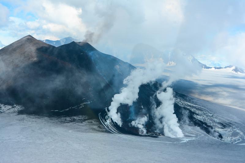
Alaska , Veniaminof :
56°11’52 » N 159°23’35 » W,
Summit Elevation 8225 ft (2507 m)
Current Volcano Alert Level: WATCH
Current Aviation Color Code: ORANGE
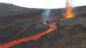
Veniaminof volcano continues to erupt with effusion of a lava flow from the cone in the ice-filled summit caldera, and continuous, low-amplitude seismic tremor. Satellite views of the volcano over the past day indicated strongly elevated surface temperatures from the active lava effusion. Clouds obscured web camera views of the summit.
Diffuse ash and steam emissions continue and trace ashfall is possible in nearby communities under favorable wind conditions.
Veniaminof volcano is monitored with a local real-time seismic network, which will typically allow AVO to detect changes in unrest that may lead to a more significant explosive eruption. Rapid detection of such an event would be accomplished using a combination of seismic, infrasound, lightning, and satellite data.
Source : AVO.
Photo : Chris Waythomas.
France / Guadeloupe , La Soufrière :
A series of volcanic earthquakes under the Soufrière.
A sequence of volcanic earthquakes began on Friday, at 21:16 local time, in the La Soufrière volcano area. This Saturday, at 1 pm, the networks of the OVSG-IPGP (Volcanological and seismological Observatory of Guadeloupe – Institute of Earth Physics of Paris) recorded 79 earthquakes of very small magnitude (M <1). No earthquake was reported as felt. The events are located at a depth of 2.5 km under the summit of the dome of La Soufrière. The alert level remains yellow, vigilance.
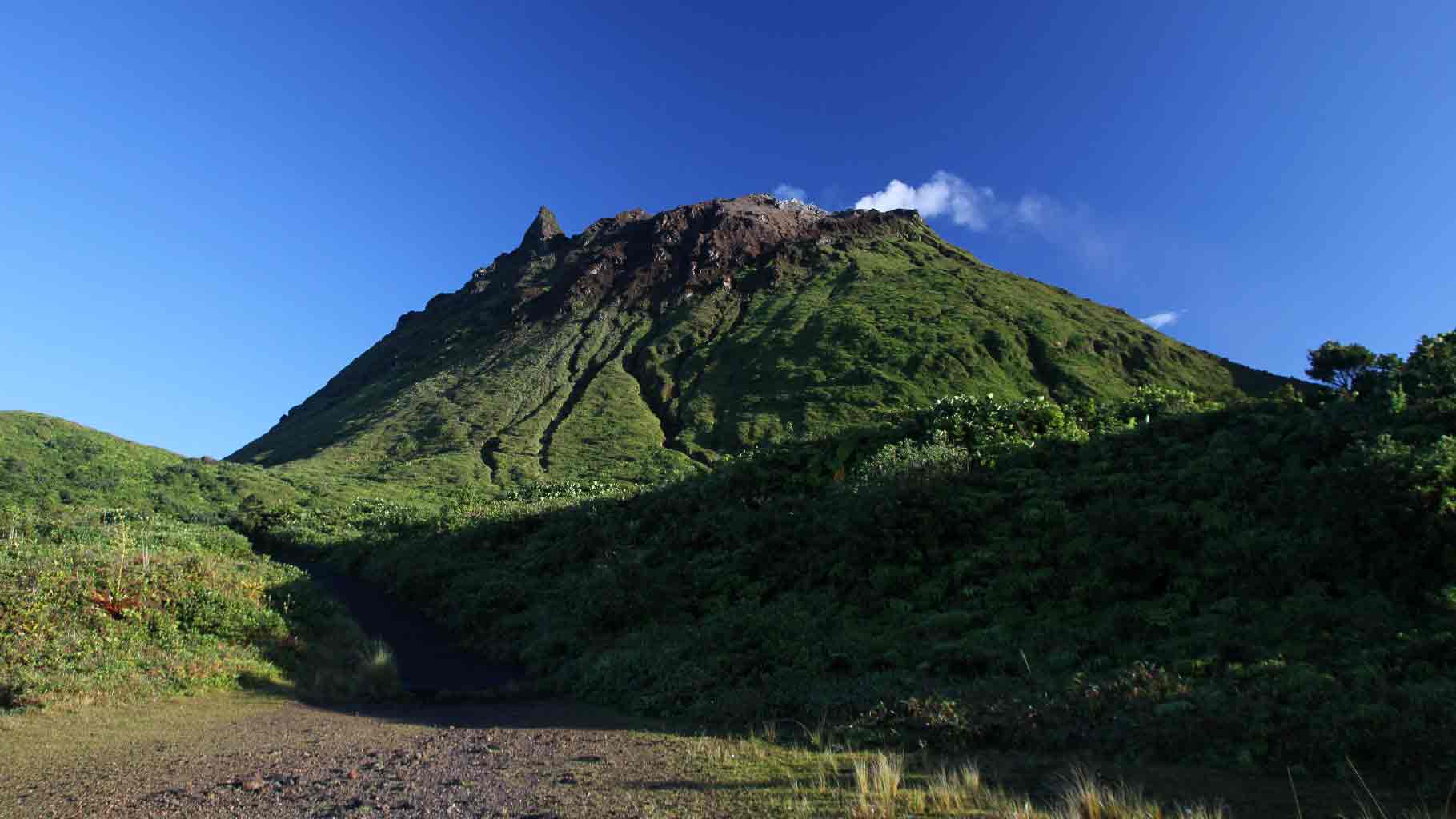
La Soufrière de la Guadeloupe volcano occupies the southern end of Basse-Terre, the western half of the butterfly-shaped island of Guadeloupe. Construction of the Grand Découverte volcano about 0.2 million years ago (Ma) was followed by caldera formation after a plinian eruption about 0.1 Ma, and then by construction of the Carmichaël volcano within the caldera. Two episodes of edifice collapse and associated large debris avalanches formed the Carmichaël and Amic craters about 11,500 and 3100 years ago, respectively. The presently active La Soufrière volcano subsequently grew within the Amic crater. The summit consists of a flat-topped lava dome, and several other domes occur on the southern flanks. Most historical eruptions have originated from NW-SE-trending fissure systems that cut across the summit and upper flanks. A relatively minor phreatic eruption in 1976-77 caused severe economic disruption when Basse-Terre, the island’s capital city, which lies immediately below the volcano, was evacuated.
Source : guadeloupe.franceantilles.fr, GVP.
Costa Rica , Turrialba / Poas :
Daily report on the state of volcanoes. OVSICORI-UNA, Date: 2018-11-24, Updated at: 10:38:00 AM.
Turrialba Volcano:
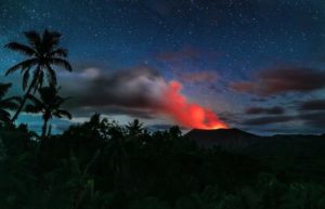
Since 23 November 2018, the Turrialba volcano has been erupting continuously. Its column rises 100 meters above the crater and 3,440 meters above sea level. (11283.2 ft).
Seismic activity is more important than yesterday.
At the time of this report, the winds are blowing west.
https://www.facebook.com/RSN.CR/videos/571700883306780/
The Turrialba volcano has been erupting continuously since yesterday, November 23 from noon. Occasionally, small explosions are recorded with the release of rock fragments. During the explosions, the column reaches 500 meters above the crater. At the time of writing, no ash drop or sulfur odor has been reported; the ashes are therefore scattered in uninhabited places.
Poas Volcano:
No eruptions are reported.
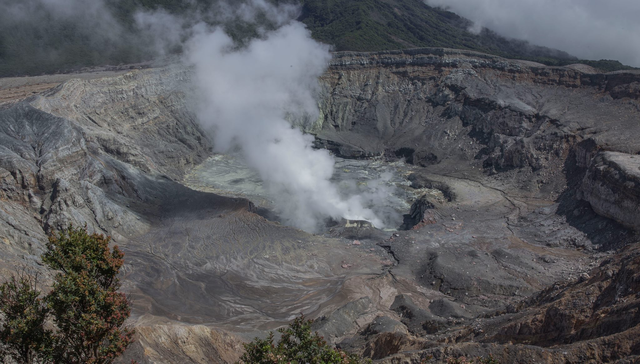
The seismic activity is lower than yesterday.
At the time of this report, the winds are blowing west.
The Poás volcano does not show signs of significant activity, although frequent low frequency and very low amplitude volcanic earthquakes are recorded.
Source : Ovsicori.
Vidéo : RSN.
Photo : RSN , Paulo Ruiz.
Mexico , Popocatepetl :
In the last 24 hours, thanks to the surveillance systems of the Popocatépetl volcano, 63 exhalations have been identified, accompanied by water vapor, gas and light amounts of ash. In addition, four volcano-tectonic earthquakes were identified, two yesterday at 10:28 and 11:04 with a magnitude of 1.8 and the rest today at 04:58 and 09:20, both of magnitude 1.7.
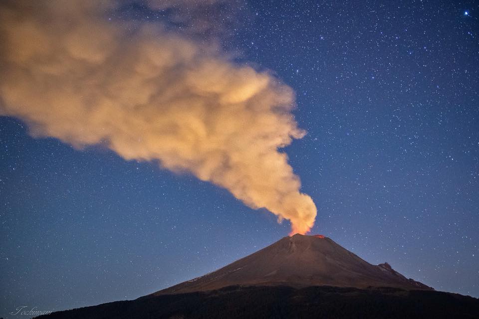
At the time of writing this report , it has been observed that emissions of water vapor, gas and small amounts of ash were dispersed to the northeast.
CENAPRED insists that the volcano, and in particular the crater, should not be approached, because of the risk of falling ballistic fragments and, in case of heavy rains, to move away from ravine bottoms because of the danger of landslides field and mudslides.
The Popocatepetl volcanic warning light is located at Amarillo Phase 2.
Source : Cenapred.
Photo : Erik Gómez Tochimani Fotógrafo