September 18 , 2018.
La Réunion , Piton de la Fournaise :
Activity Bulletin from Monday 17 September 2018 at 09:00 (local time)
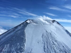
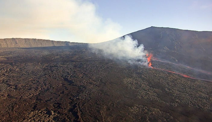
The eruption that began September 15 at 4:25 am local time continues. The volcanic tremor (indicator of surface eruptive intensity) has been stable and weak since 18:00 on 15 September (14:00 UT).
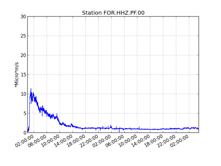
Figure 1: Evolution of the RSAM (indicator of the volcanic tremor and the intensity of the eruption) between 04:00 (00h UTC) on September 15 and 09:08 (05:08 UTC) September 17 on the seismic station of FOR, located near the Château-fort crater (2000 m altitude to the southeast of the summit).
Fourteen volcano-tectonic earthquakes were recorded beneath the summit craters during the day of September 16th.
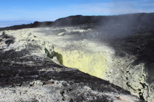
– The SO2 emissions recorded by the OVPF’s permanent sensors are much higher than the atmospheric background (related to the volcanic gas plume), and are mostly dispersed west and south since early morning, but are still noticeable at Mountain peak.
https://www.facebook.com/B.FILMS974/videos/2108639419169479/
– No deformation is noticeable since the beginning of the eruption.
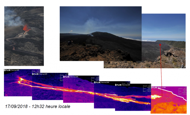
– The surface flows estimated from satellite data, via the HOTVOLC platform (OPGC – University of Auvergne), are between 2.5 and 5 m3 / s for the start of the day on 17 September.
– During the night, the lava flow continued mainly in the southernmost channel. A visual recognition from Bert’s piton will be made today to try to assess the position of the flow front.
Activity Bulletin from Monday 17 September 2018 at 17:30 (local time)
The eruption that began September 15 at 4:25 am local time continues. The volcanic tremor (indicator of surface eruptive intensity) has been stable and weak since 18:00 on 15 September (14:00 UT).
https://www.facebook.com/LaReunionVueDuCiel/videos/2129882390589858/
– The SO2 emissions recorded by the OVPF’s permanent sensors are much higher than the atmospheric background (related to the volcanic gas plume), and are mostly dispersed west and south since the beginning of the day.
– No deformation is noticeable since the beginning of the eruption.
– The surface flows estimated from the satellite data, via the HOTVOLC platform (OPGC – University of Auvergne), remain between 2.5 and 5 m3 / s.
– The flow front is always in the upper part of the enclosure. The flow continues its progression towards the east by not getting closer progressively of the southern rampart of the Enclos Fouqué.
Source : OVPF
Videos : Facebook : B Films / Banor Jérôme , La Réunion vue du ciel / Alexandre Haffner.
Photo : OVPF
Aleutians Islands, Semisopochnoi:
AVO/USGS Volcanic Activity Notice
Current Volcano Alert Level: ADVISORY
Previous Volcano Alert Level: UNASSIGNED
Current Aviation Color Code: YELLOW
Previous Aviation Color Code: UNASSIGNED
Issued: Sunday, September 16, 2018, 9:56 AM AKDT
Source: Alaska Volcano Observatory
Notice Number:
Location: N 51 deg 55 min E 179 deg 35 min
Elevation: 2625 ft (800 m)
Area: Aleutians
Volcanic Activity Summary:
An increase in seismicity beginning 16:31 UTC (08:31 AKDT) on has prompted AVO to raise the Aviation Color Code and Volcano Alert Level to YELLOW/ADVISORY.
There is no clear indication from satellite imagery or regional infrasound data that Semisopochnoi is erupting at this time. AVO will continue to monitor Semisopochnoi seismic data and evaluate satellite images.
Recent Observations:
[Volcanic cloud height] Unknown
[Other volcanic cloud information] Unknown
Semisopochnoi, the largest subaerial volcano of the western Aleutians, is 20 km wide at sea level and contains an 8-km-wide caldera. It formed as a result of collapse of a low-angle, dominantly basaltic volcano following the eruption of a large volume of dacitic pumice. The high point of the island is 1221-m-high Anvil Peak, a double-peaked late-Pleistocene cone that forms much of the island’s northern part. The three-peaked 774-m-high Mount Cerberus volcano was constructed during the Holocene within the caldera. Each of the peaks contains a summit crater; lava flows on the northern flank of Cerberus appear younger than those on the southern side. Other post-caldera volcanoes include the symmetrical 855-m-high Sugarloaf Peak SSE of the caldera and Lakeshore Cone, a small cinder cone at the edge of Fenner Lake in the NE part of the caldera. Most documented historical eruptions have originated from Cerberus, although Coats (1950) considered that both Sugarloaf and Lakeshore Cone within the caldera could have been active during historical time.
This volcano is located within the Aleutian Islands, a UNESCO Biosphere Reserve property.
AVO/USGS Volcanic Activity Notice
Current Volcano Alert Level: WATCH
Previous Volcano Alert Level: ADVISORY
Current Aviation Color Code: ORANGE
Previous Aviation Color Code: YELLOW
Issued: Monday, September 17, 2018, 1:33 PM AKDT
Source: Alaska Volcano Observatory
Notice Number:
Location: N 51 deg 55 min E 179 deg 35 min
Elevation: 2625 ft (800 m)
Area: Aleutians
Volcanic Activity Summary:
Elevated seismicity that started yesterday has intensified over the past couple of hours, and a strong tremor signal at 20:49 UTC (12:49 AKDT) suggests that ash emissions may be occurring or are imminent at Semisopochnoi. Thus we are raising the Aviation Color Code to ORANGE and the Volcano Alert Level to WATCH.
Nothing has been detected in satellite, lightning, or infrasound data.
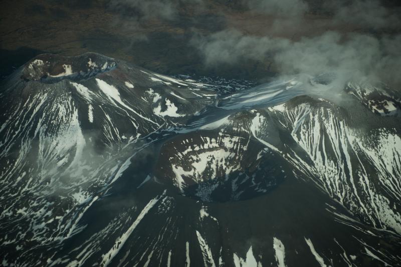
Close-view of the three summits of Mount Cerberus, a large, young, post-caldera vent cluster that dominates the interior of the caldera basin. Semisopochnoi Island, in November 2012. Photograph courtesy of Roger Clifford.
Recent Observations:
[Volcanic cloud height] Unknown
[Other volcanic cloud information] Unknown
Remarks:
Semisopochnoi is monitored with an on-island seismic network, and remotely by satellite and lightning sensors. An infrasound array on Adak Island could detect explosive emissions from Semisopochnoi with a 13 minute delay if atmospheric conditions permit.
Retrospective analysis of satellite data from September 10 shows evidence of a small ash deposit on the flanks of the north cone of Mount Cerberus, which may have resulted from two minor seismic tremor bursts recorded on September 8. This satellite imagery, combined with a further increase in seismic tremor amplitudes today, prompted AVO to raise the Aviation Color Code and Volcano Alert Level to ORANGE/WATCH. While the recent ash deposit suggests the potential for ash emissions coincident with elevated seismicity, there have been no ash emissions observed in cloudy satellite images around the time of today’s tremor increase. Furthermore, there has been no eruptive activity recorded on regional pressure sensors in Adak, although current atmospheric conditions limit signal propagation between Semisopochnoi and Adak.
Source : AVO
Photo : Clifford, Roger , Novembre 2012
Peru , Sabancaya :
An average of 13 EXP / day was recorded. Earthquakes associated with the rise of magma (hybrid types) remain very few and low energy.
The columns of gas and eruptive ash reached a maximum height of 2500 m above the crater. The dispersion of these materials occurred within a radius of approximately 30 km, mainly in the North, Northeast and Southeast directions.

The volcanic gas (SO2) flow recorded on September 12 a maximum value of 2060 tons / day, considered as a significant value.
The deformation of the surface of the volcanic building presented deflationary variations in the vertical component.
The MIROVA satellite system recorded 7 thermal anomalies, with values between 1 MW and 17 MW VRP (Radiated Volcano Power).
In general, eruptive activity maintains moderate levels. No significant changes are expected in the following days.
Source : IGP
Japan , Azumayama :
The meteorological agency has raised the alert level of eruption level 1 to level 2 (regulation around the crater) at 13:00 today on the Azumayama, and indicated that there was the possibility of a small-scale eruption. At the same time, Fukushima Prefecture, Fukushima City and Inawashiro-machi City have decided to close all the lines of the Bandai Azuma Skyline, to close each Jodohei facility and to close all the roads for the time being. surrounding mountaineering.
https://www.facebook.com/yasusan.k/videos/1707564552678079/
On Azumayama, an earthquake occurred around 9:13 am today (Sept. 15). The maximum amplitude was 6.7 micro m / s at the eastern observation point of Azuma Fuji (about 2 km east-southeast of the crater) and lasted about 4 minutes and 40 seconds. In addition, on the inclinometer installed at the observation point of the Jodo Plain (about 1 km east-southeast of the crater), the fluctuation of the slope continues to increase in the west direction (direction of the crater). ). It is possible that a small eruption will occur in the future.
The animation of Azumayama is dated September 15th around noon.
Source : Yasuhiro Kikuchi / Shérine France.
Kuril Islands , Sarychev Peak:
VOLCANO OBSERVATORY NOTICE FOR AVIATION (VONA) .
Issued: September 17 , 2018
Volcano:Sarychev Peak (CAVW #290240)
Current aviation colour code:ORANGE
Previous aviation colour code:orange
Source:KVERT
Notice Number:2018-91
Volcano Location:N 48 deg 5 min E 153 deg 12 min
Area:Central Kuriles, Russia
Summit Elevation:4906.88 ft (1496 m)
Volcanic Activity Summary:
An eruptive activity of the volcano continues. According to visual data from Matua Island, explosions sent ash up to 4.5 km a.s.l. at 22:10 UTC on 17 September. Satellite data by KVERT showed an ash cloud 6×8 km in size drift to the east from the volcano.
An eruptive activity of the volcano continues. Ash explosions up to 32,800-49,200 ft (10-15 km) a.s.l. could occur at any time. Ongoing activity could affect international and low-flying aircrafts.
Volcanic cloud height:
14760 ft (4500 m) AMSL Time and method of ash plume/cloud height determination: 20180917/2210Z – Visual data
Other volcanic cloud information:
Distance of ash plume/cloud of the volcano: 13 mi (21 km)
Direction of drift of ash plume/cloud of the volcano: E / azimuth 92 deg
Time and method of ash plume/cloud determination: 20180917/2230Z – Himawari-8
Source : Kvert
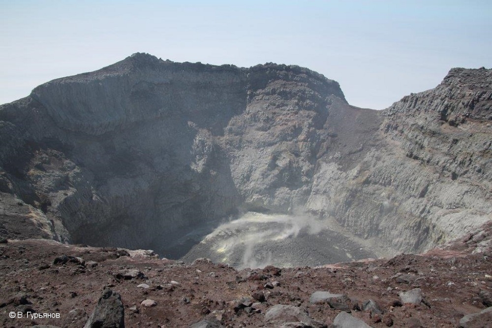
Photo : V. Gurianov