July 28 , 2018.
Vanuatu , Ambae :
Vanuatu Island of 10,000 Evacuated Again After Volcano Erupts, Triggers New State of Emergency
Evacuation orders and a state of emergency were issued once again Friday for a South Pacific island in Vanuatu after an eruption at the Manaro Voui Volcano spewed dark ash into the air.
The country’s cabinet declared a state of emergency and ordered the mandatory evacuation of the entire island of Ambae, one of 65 inhabited islands that make up Vanuatu, lawmaker Ralph Regenvanu tweeted Friday. The island is home to about 10,000 people.
In September, the 154-square-mile island was evacuated when a cycle of eruptions began after several years of relative quiet. Since then, recurring eruptions prompted lawmakers in March to urge residents to consider permanently relocating somewhere else.
Ambae resident Lillian Garae, 39, told the Associated Press sleep was made difficult by the noise of the eruption, and the poor air quality aggravated asthma in some young children.
https://www.facebook.com/sherinefrance/videos/1831017770296744/
UPDATE ON AMBAE VOLCANO ACTIVITY 27th July 2018 at 9:00 am:
Ongoing volcanic ash emission from Ambae volcano, areas from South-West to West of Ambae that are exposed to the trade wind direction will continue to expect ash fall. The volcanic Alert Level remains at Level 3 and danger to direct safety to life for visitors and communities remains at 3 km radius around the eruptive vent.
Similar activity will continue to be expected at Level 3. The possibility of immediate decrease of volcano activity on Ambae is low.
The local population from Ambae and from neighboring islands will continue to hear rumbling, volcanic explosions, smelt volcanic gases, see volcanic ash and gas plume and glows over the mountain at night.
UPDATE ON AMBAE VOLCANO ACTIVITY 27th July 2018 at 11:30 am:
Ongoing volcanic ash emission from Ambae volcano, areas from South-East to East of Ambae including neighboring islands that are exposed to the upper level wind direction will continue to expect ash fall. The volcanic Alert Level remains at Level 3 and danger to direct safety to life for visitors and communities remains at 3 km radius around the eruptive vent.
Similar activity will continue to be expected at Level 3.
The possibility that the Ambae volcano activity escalate to the level of moderate eruption is now moderate to high.
Source : weather.com , Geohazard .
Alaska , Cleveland :
52°49’20 » N 169°56’42 » W,
Summit Elevation 5676 ft (1730 m)
Current Volcano Alert Level: WATCH
Current Aviation Color Code: ORANGE
Unrest continues at Cleveland volcano. Weakly elevated surface temperatures consistent with cooling lava were observed in high resolution satellite data over the past week. No significant activity was detected in seismic and infrasound (pressure) sensor data throughout the week. Steaming at the summit was visible in both web camera and satellite images at times. During the week, a small deposit of ballistic blocks was observed in satellite data within the summit crater and just below the eastern crater rim. These blocks suggest very small explosive activity occurred recently at the summit that is below the detection threshold of the seismic and pressure sensors.
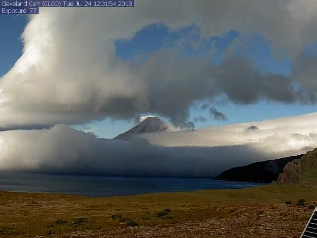
Cleveland webcam catches a glimpse of the summit, with minor steaming, July 24, 2018.
Future explosive activity is likely and is expected to occur without warning. Previous explosions have produced hazardous conditions primarily near the volcano, but occasionally they have been large enough to produce a drifting ash cloud.
Source : AVO.
Photo : Webcam CLCO.
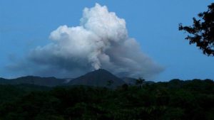
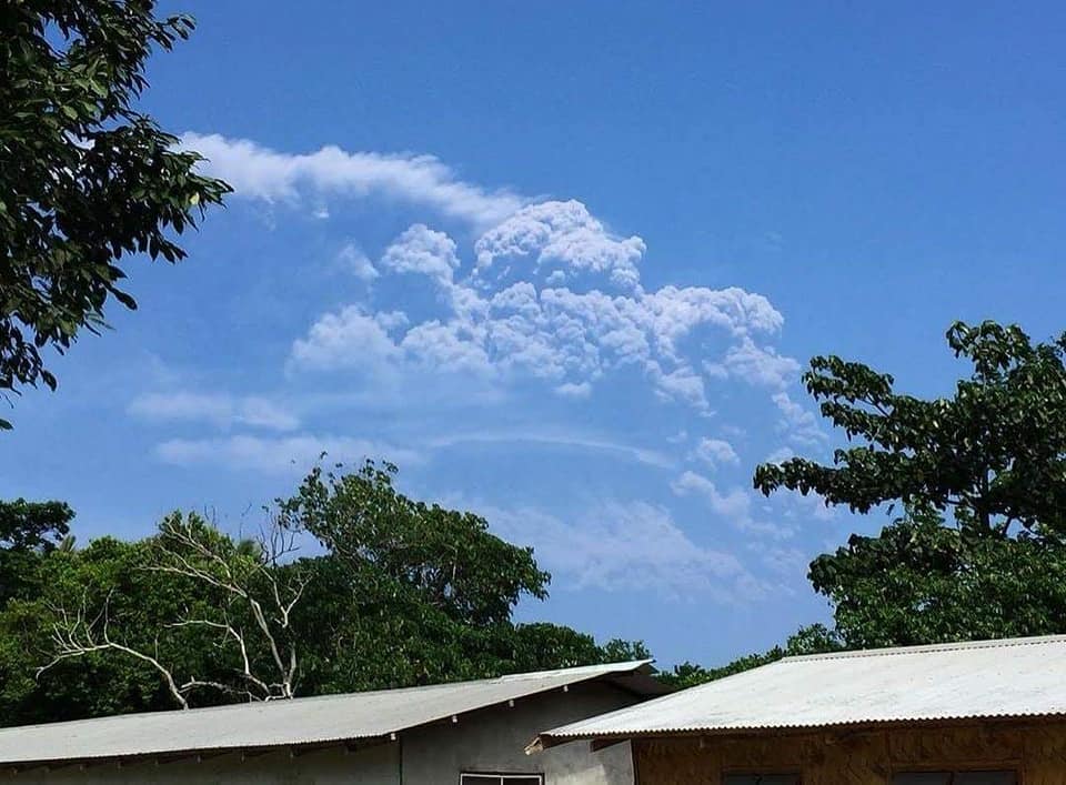
Indonesia , Agung :
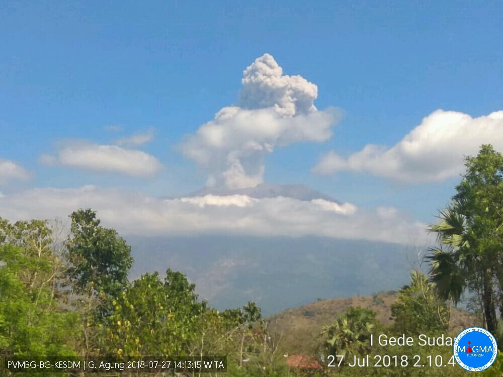
There was an eruption of G. Agung on 27 July 2018 at 14:06, with a column of ash observed at a height of ± 2000 m above the peak (± 5,142 m above sea level) . The emissions are observed from white to gray, with a strong intensity, bowing to the west. This eruption is recorded on seismograms with a maximum amplitude of 22 mm and a duration of ± 1 minute 32 seconds.
Currently, G. Agung is at Level III (SIAGA) status with recommendations:
(1) The communities around G. Agung and climbers / visitors / tourists must avoid climbing and carrying out activities in the danger zone, ie in all areas within a radius of 4 km around G. Agung. The estimated area hazards are dynamic and continuously assessed and can be modified at any time based on the most recent observational data from G. Agung.
(2) Communities living around the rivers that descend from Gunung Agung are aware of potential secondary hazards such as lahar flows that can occur especially during the rainy season and if eruption materials are still deposited.
VOLCANO OBSERVATORY NOTICE FOR AVIATION – VONA .
Issued: July 27 , 2018.
Volcano: Agung (264020)
Current Aviation Colour Code: ORANGE
Previous Aviation Colour Code: orange
Source: Agung Volcano Observatory
Notice Number: 2018AGU57
Volcano Location: S 08 deg 20 min 31 sec E 115 deg 30 min 29 sec
Area: Bali, Indonesia
Summit Elevation:10054 FT (3142 M)
Volcanic Activity Summary:
Eruption with emising gas ash cloud at 06h06 UTC (14h06Local), Eruption is not continue
Volcanic Cloud Height:
Best estimate of ash-cloud top is around 16454 FT (5142 M) above sea level, may be higher than what can be observed clearly. Source of height data: ground observer.
Other Volcanic Cloud Information:
Ash-cloud is moving to west
Remarks:
seismic activity is dominated by low frequency earthquake
Source : PVMBG.
Hawai , Kilauea :
Friday, July 27, 2018, 12:02 PM HST (Friday, July 27, 2018, 22:02 UTC)
19°25’16 » N 155°17’13 » W,
Summit Elevation 4091 ft (1247 m)
Current Volcano Alert Level: WARNING
Current Aviation Color Code: ORANGE
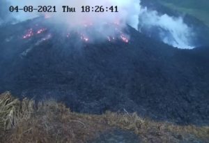
Kīlauea Volcano Lower East Rift Zone
Fissure 8 continues to erupt lava into the channel leading northeastward from the vent. No new overflows were reported this morning despite the channel appearing nearly full. At the coast, the south edge of the lava flow showed no incandescence this morning and remains less than 0.1 miles from the Pohoiki boat ramp in Isaac Hale Park. The active ocean entry is a few hundred yards to the east of this lava flow edge.
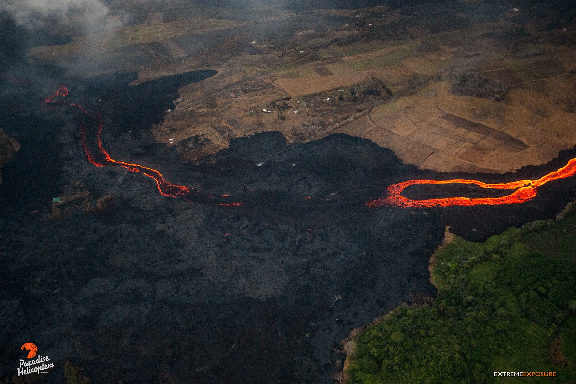
No other fissures are active this morning.
Kīlauea Volcano Summit
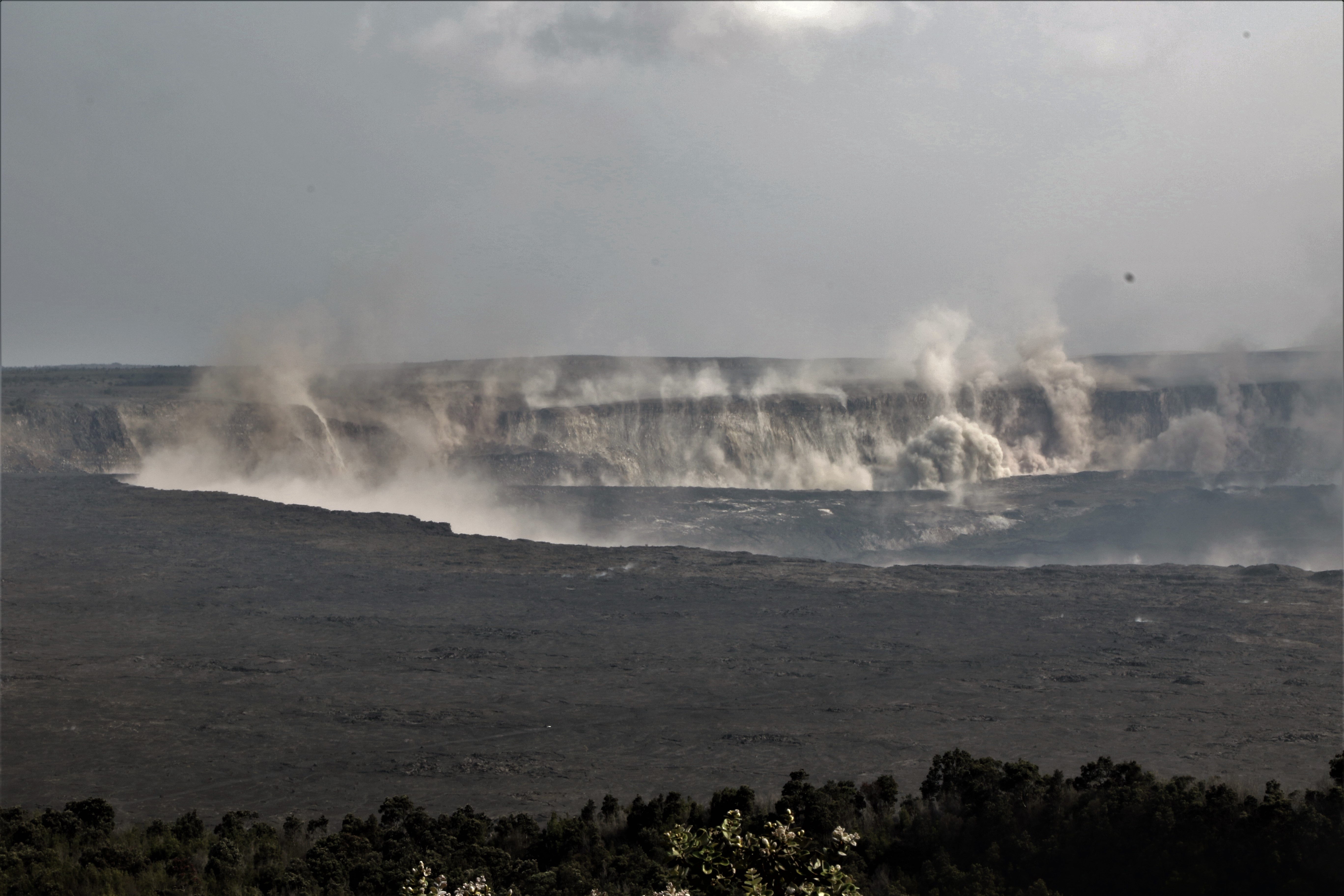
Earthquakes shook the ground at Kīlauea’s summit late this afternoon, stirring up rock dust within Halema‘uma‘u and along the caldera walls. This view from the northeast caldera rim looks across at the Keanakāko‘i and South Sulphur Banks areas.
The most recent collapse event occurred at 12:09 PM HST July 26, and was similar in character and magnitude to previous events; the time interval between the last two collapse events (almost 53.5 hours) was the longest since early June. Seismicity has increased steadily since yesterday’s collapse event and has already reached 30-35 events per hour. The next collapse event is expected tomorrow.
Source : HVO
Photos : Bruce Omori , HVO .
Mexico , Popocatepetl :
July 27, 11:00 am (July 27, 16:00 GMT)
In the last 24 hours, thanks to the monitoring systems of the Popocatepetl volcano, 42 low intensity exhalations, accompanied by steam and gas were identified, the visibility was partial. During the night, a weak incandescence was observed during certain exhalations. In addition, a volcano-tectonic event, was recorded today at 00:26 pm with a magnitude of 1.7 M, as well as nine explosions, four yesterday at 11:26, 11:41, 18:32 and 23:26 h, and five today at 03 : 02, 04:03, 07:07, 08:00 and 10:27 h.
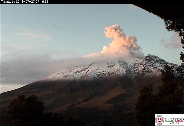
At the time of this report, there is an emission of water vapor and gas that the wind disperses to the West.
CENAPRED urges not to approach the volcano and especially the crater, because of the risk of falling ballistic fragments, and in case of heavy rains, to move away from the bottom of the ravines because of the risk of landslides and mudslides.
The Popocatepetl volcanic warning light is located at Amarillo Phase 2.
Source : Cenapred .