July 21 , 2018.
Japan , Nishinoshima :
Eruption on remote island continues.
The Japan Coast Guard says the latest volcanic eruption on a remote island in the Pacific Ocean is continuing.
Nishinoshima had a minor eruption, its first since last August, on July 12th. The uninhabited volcanic island is about 1,000 kilometers south of Tokyo.
Coast guard officials conducted an aerial survey on Wednesday and spotted a 600-meter-long lava flow from a new crater on the island’s eastern slope.
The officials also saw smoke rising about 200 meters high and volcanic gas spewing continuously.
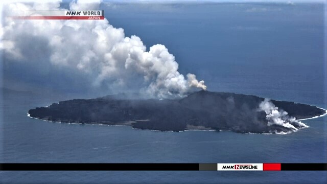
Tokyo Institute of Technology Professor Kenji Nogami, who took part in the survey, says magma may be rising close to the surface and volcanic activity has restarted.
He expects the volcano to keep spewing lava for some time.
From 2013, Nishinoshima had active eruptions for about 2 years.
The Meteorological Agency has issued a warning for flying rocks and lava flows within a 1.5-kilometer radius from the crater.
Source : www3.nhk.or.jp
Hawaii , Kilauea :
Friday, July 20, 2018, 10:29 AM HST (Friday, July 20, 2018, 20:29 UTC)
19°25’16 » N 155°17’13 » W,
Summit Elevation 4091 ft (1247 m)
Current Volcano Alert Level: WARNING
Current Aviation Color Code: ORANGE
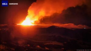
Kīlauea Volcano Lower East Rift Zone
Fissure 8 continues to erupt lava into the perched channel leading northeastward from the vent. During this morning’s overflight, the channel was incandescent its entire length from vent to ocean entry. The most vigorous ocean entry is located a few hundred meters northeast of the southern flow margin, though a few small pahoehoe toes were entering the ocean on either side of the channel’s main entry point. The southern margin of the flow is unchanged from yesterday, and about 500 m (0.3 mi) from the boat ramp at Isaac Hale Park.
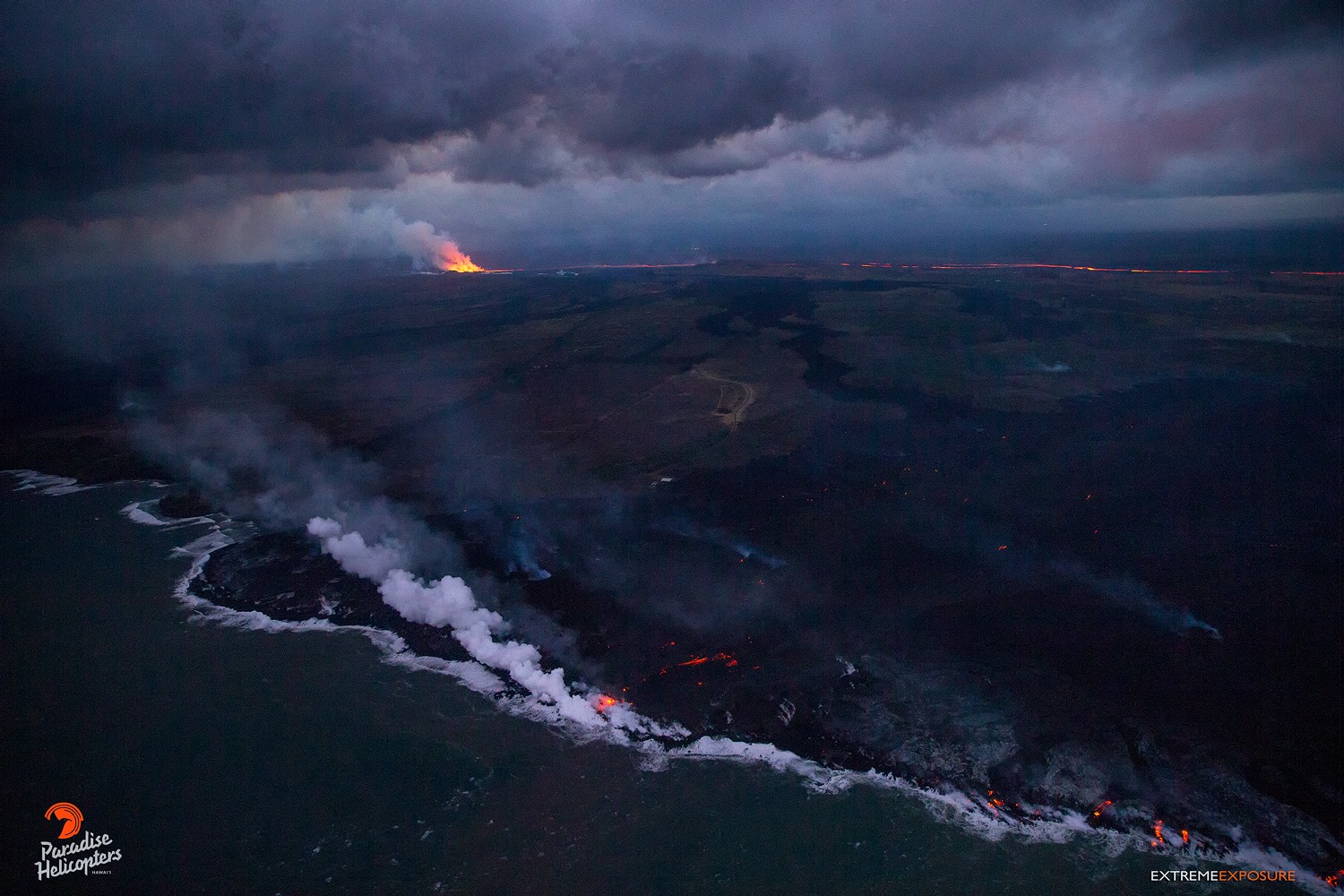
An early evening pass over the ocean entry showed that the volume of lava entering the sea has slowed, at least for the moment, as the number of rivulets and size of the plume was significantly less than during the morning overflight.
No other fissures are active this morning.
Kīlauea Volcano Summit
The last collapse event occurred at 4:36 p.m. HST yesterday (July 19). Seismicity at the summit decreased immediately following the event and is now back to 20-40 earthquakes per hour. The next collapse event is expected to occur tonight or tomorrow Morning.
Source : HVO.
Photo : Bruce OMORI
Alaska : Cleveland :
52°49’20 » N 169°56’42 » W,
Summit Elevation 5676 ft (1730 m)
Current Volcano Alert Level: WATCH
Current Aviation Color Code: ORANGE
Low-level unrest continues at Cleveland volcano. Weakly elevated surface temperatures consistent with cooling lava were observed in high resolution satellite data over the past week, when weather conditions were clear. No significant activity was detected in seismic and pressure sensor data throughout the past week. Field crews working on Chuginadak Island yesterday repaired the Cleveland web camera. The volcano was obscured by foggy weather in images from this morning.
Future explosive activity is likely and is expected to occur without warning. Previous explosions have produced hazardous conditions primarily near the summit crater, but occasionally they have been large enough to produce a drifting ash cloud.
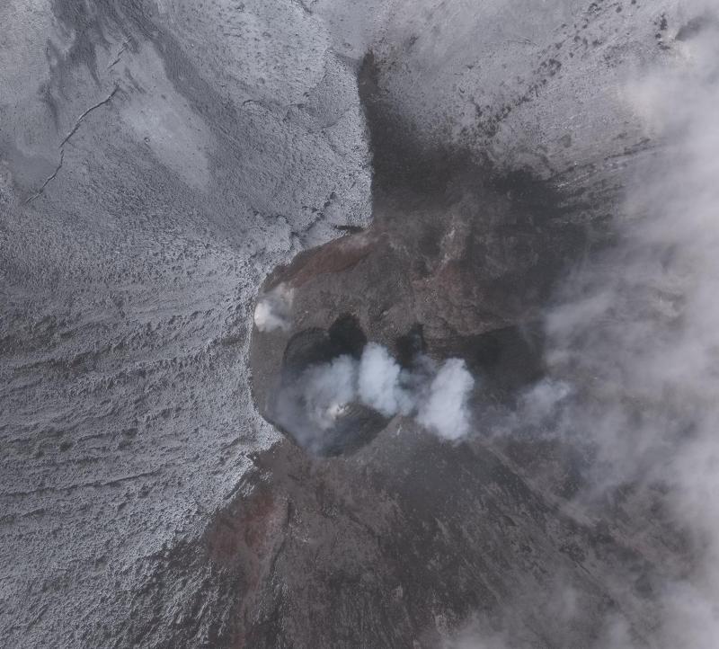
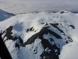
Image satellite Worldview-3 du cratère sommital du volcan Cleveland collecté le 10 juillet 2018. Le flux de lave circulaire de 80 mètres de diamètre qui a été extrudé fin juin 2018 peut être vu ainsi que des émissions de vapeur mineures.
Cleveland volcano is monitored by only two seismic stations, which restricts AVO’s ability to detect precursory unrest that may lead to an explosive eruption. Rapid detection of an ash-producing eruption may be possible using a combination of seismic, infrasound, lightning, and satellite data.
Cleveland volcano forms the western portion of Chuginadak Island, a remote and uninhabited island in the east central Aleutians. The volcano is located about 75 km (45 mi) west of the community of Nikolski, and 1500 km (940 mi) southwest of Anchorage. The most recent significant period of eruption began in February, 2001 and produced 3 explosive events that generated ash clouds as high as 39,000 ft above sea level. The 2001 eruption also produced a lava flow and hot avalanche that reached the sea. Since then, Cleveland has been intermittently active producing small lava flows, often followed by explosions that generate small ash clouds generally below 20,000 ft above sea level. These explosions also launch debris onto the slopes of the cone producing hot pyroclastic avalanches and lahars that sometimes reach the coastline .
Source : AVO
Photo : Schneider, Dave, 1 Juillet 2018.
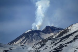
Indonesia , Agung :
VOLCANO OBSERVATORY NOTICE FOR AVIATION – VONA.
Issued: July 21 , 2018.
Volcano: Agung (264020)
Current Aviation Colour Code: ORANGE
Previous Aviation Colour Code: orange
Source: Agung Volcano Observatory
Notice Number: 2018AGU55
Volcano Location: S 08 deg 20 min 31 sec E 115 deg 30 min 29 sec
Area: Bali, Indonesia
Summit Elevation: 10054 FT (3142 M)
Volcanic Activity Summary:
Eruption with volcanic ash cloud at 03h49 UTC (11h49 local). Eruption and ash emission is not continuing
Volcanic Cloud Height:
Best estimate of ash-cloud top is around 14854 FT (4642 M) above sea level, may be higher than what can be observed clearly. Source of height data: ground observer.
![]()
Other Volcanic Cloud Information:
Ash-cloud moving to west
Remarks:
Seismic activity is characterized by low frequency earthquakes.
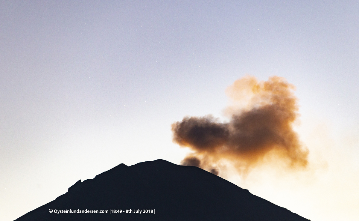
Level of Activity : Level III (SIAGA). G. Agung (3142 m above sea level) has been erupting since 21 November 2017.
Since yesterday until this morning, visually the weather is sunny to cloudy, the wind is weak to moderate, oriented towards the Southwest and the West. The volcano was clearly visible until it was covered with fog. Crater smoke was observed up to 500 m above the summit.
The seismographs, July 19, 2018 recorded:
13 emission earthquakes
3 shallow volcanic earthquakes
9 distant tectonic earthquakes
On July 20, 2018 (from 00:00 to 18:00), it was recorded:
2 emission earthquakes
12 distant tectonic earthquakes
Recommendations:
Communities in general and mountaineers / visitors / tourists must not climb or carry out any hazardous area activity that is planned throughout the area within a radius of 4 km around the crater.
The estimated area hazards are dynamic and continuously assessed and can be modified at any time based on the most recent observational data from G. Agung.
People who live and move around streams coming down from Gunung Agung should be aware of the potential danger of a secondary form of lava flow, the lahars that can occur, especially during the rainy season.
Level III (SIAGA) status applies only within a 4 km radius as mentioned above, outside the area of activity, one can move as usual, but one must maintain vigilance on activity very dynamic Mount Agung.
Source : Magma Indonésie , PVMBG.
Photos : Oystein Lund Andersen ( www.oysteinlundandersen.com/agung-volcano-bali-eruptive-activity-of-6-9th-july-2018/ )