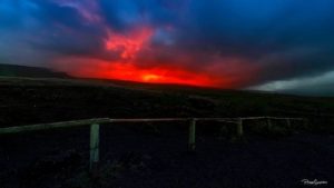
July 06 , 2018 .
Indonesia , Anak Krakatau :
VOLCANO OBSERVATORY NOTICE FOR AVIATION – VONA.
Issued: July 05 , 2018 .
Volcano: Anak Krakatau (262000)
Current Aviation Colour Code: ORANGE
Previous Aviation Colour Code: orange
Source: Anak Krakatau Volcano Observatory
Notice Number: 2018KRA13
Volcano Location: S 06 deg 06 min 07 sec E 105 deg 25 min 23 sec
Area: Lampung, Indonesia
Summit Elevation: 976 FT (305 M)
Ash plume of Krakatau yesterday (Black Carita via Volcanist Andi / VolcanoDiscovery)
Volcanic Activity Summary:
Eruption with ash clouds at 07:25 UTC (14:25 local time). The eruption lasted for 33 seconds. Eruption and ash emission is continuing.
Volcanic Cloud Height:
Best estimate of ash-cloud top is around 1936 FT (605 M) above sea level, may be higher than what can be observed clearly. Source of height data: ground observer.
Other Volcanic Cloud Information:
Ash cloud is moving to north
Remarks:
Eruption recorded on seismogram with maximum amplitude 41 mm and maximum duration 33 second.
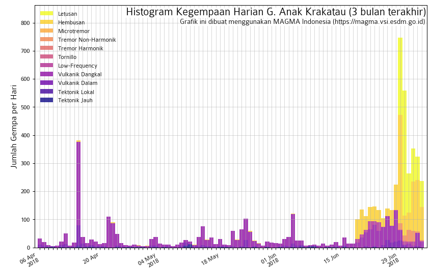
Level II Activity Level (WASPADA). G. Anak Krakatau has increased his activity since June 18, 2018.
Since yesterday until this morning, visually the mountain seems clear without fog. The wind is blowing weakly to moderately to the west, north-west, north-east.
The seismographs of July 5, 2018 recorded:
116 earthquakes of eruption
153 emission earthquakes
5 shallow volcanic earthquakes
2 deep volcanic earthquake
Continuous tremor, amplitude 1-4 mm (dominant value 1 mm)
Source : Magma Indonésie. PVMBG.
Photo : Black Carita via Andi Volcanist / VolcanoDiscovery / Jeannie Curtis.
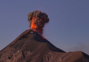
Guatemala , Pacaya :
Type of activity: Strombolian
Morphology: Composite Stratovolcano
Location: 14 ° 22’50˝ Latitude N; 90 ° 36’00˝ Longitude W.
Height: 2,552msnm.
Weather Conditions: Partly Cloudy
Wind: South West at 5 km / h
Precipitation: 0.0 mm
https://www.facebook.com/adrenalina.tours/videos/1035319176615882/
Activity:
The Pacaya volcano has a lava flow 700 meters long and 60 meters wide, which descends from the crater on the north flank. In the Mackenney crater, small Strombolian explosions are observed, reaching 25 meters, depositing material inside. The PCG seismic station records the tremor (internal vibration) generated by the gas pressure and the descent of the lava flows.
INSIVUMEH reported that from 28 to 29 June and from 1 to 3 July, strombolian explosions on Pacaya’s Mackenney crater ejected materials up to 30 m above the edge of the crater. Plumes of white gas have drifted South.
Source : Insivumeh , GVP.
Vidéo : Adrenaline tour Guatemala.
Photo : Lared
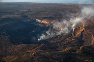
Hawai , Kilauea :
Thursday, July 5, 2018, 10:07 AM HST (Thursday, July 5, 2018, 20:07 UTC)
19°25’16 » N 155°17’13 » W,
Summit Elevation 4091 ft (1247 m)
Current Volcano Alert Level: WARNING
Current Aviation Color Code: ORANGE
Kīlauea Volcano Lower East Rift Zone
The eruption in the lower East Rift Zone (LERZ) continues with no significant change during the past 24 hours.
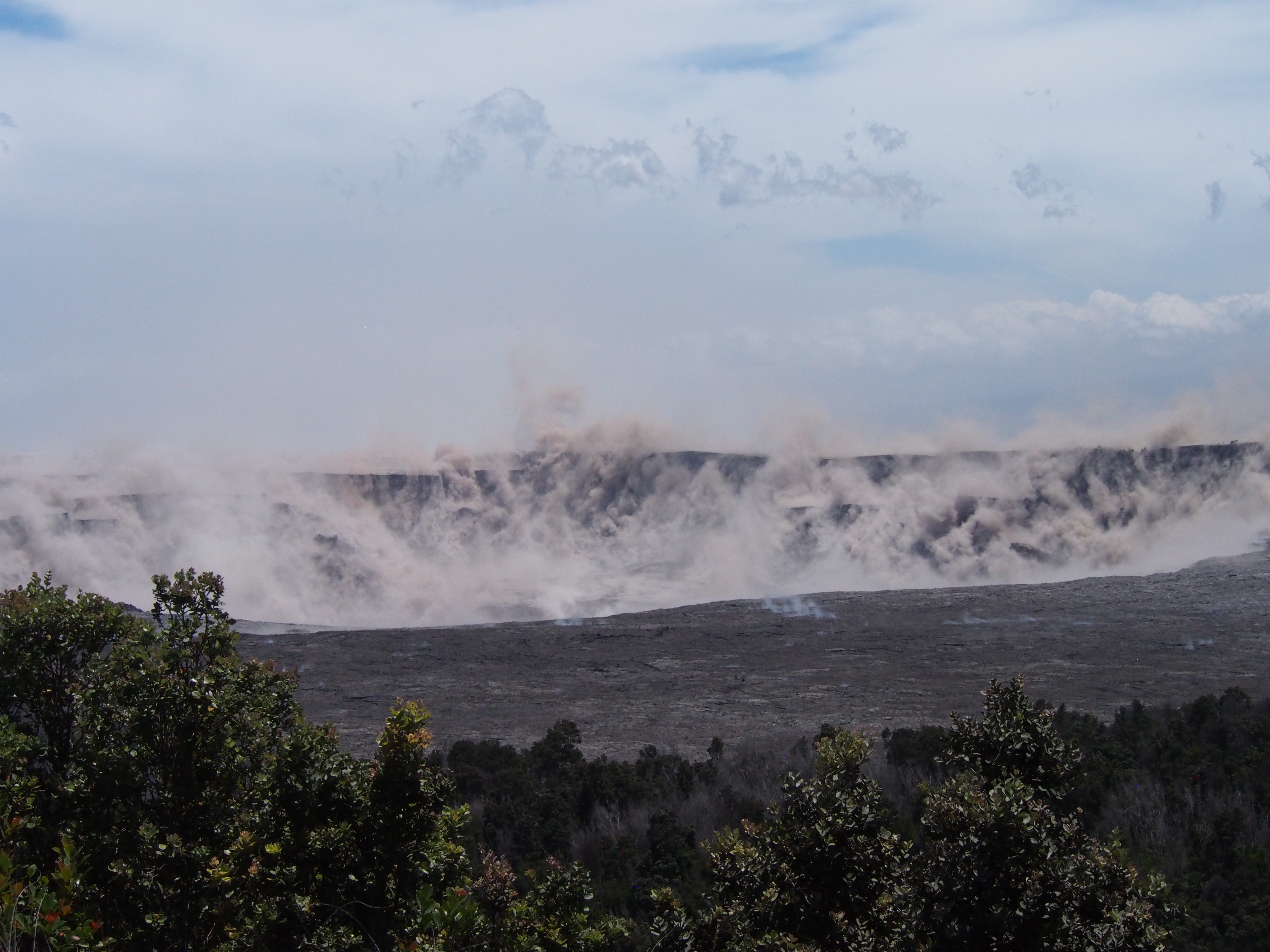
Fountains from Fissure 8 spatter cone continue to supply lava to the open channel with intermittent small, short-lived overflows. The spatter cone is now about 55 m (180 ft) tall at its highest point, and fountains rarely rise above that point. The crew on this morning’s overflight thought that the fountain and lava level in the upper channel were lower than on past mornings. North of Kapoho Crater, small overflows from the channel continued active and nearly reached the Beach Rd about 0.3 km (0.2 mi) north of Four Corners. Between Kapoho Crater and the coast, the northern margin of the flow field is still oozing pasty lava at several points in the area of Kapoho Ag and Beach Lots. Drone overflights in the early morning and a later morning helicopter overflight found a increase in lava flow rate at Beach Lots. Lava was entering the sea over a broad area this morning primarily on the northern side of the flow front. As shown by the July 02n thermal map of the flow field, the lava channel has crusted over about 0.8 km (0.5 mi) inland of the ocean entry; lava is oozing from the flow’s molten interior into the ocean along most of its broad front.
A view of the 4 corners area where a significant overflow occurred two days ago, due to a blockage. Majority of the volume is now flowing around and back into the original channel, while just downslope the flow expands significantly to the north (to the left of the frame). A few spots of activity are pushing to the south in the upper left middle of the image.
Fissure 22 is sporadically spattering this morning; its flow was not incandescent overnight and possibly stalled.
Pele’s hair and other lightweight volcanic glass fragments from the lava fountain at Fissure 8 continue to fall downwind of the fissure, dusting the ground within a few hundred meters (yards) of the vent. High winds may waft lighter particles to greater distances. Residents are urged to minimize exposure to these volcanic particles, which can cause skin and eye irritation similar to volcanic ash.
HVO field crews are on site tracking the fountains, lava flows, and spattering from Fissure 8 as conditions allow and are reporting information to Hawaii County Civil Defense. Observations are also collected on a daily basis from cracks in the area of Highway 130; no changes in temperature, crack width, or gas emissions have been noted for several days.
https://www.facebook.com/lavaocean/videos/10216548469852202/
The ocean entry is a hazardous area. Venturing too close to an ocean entry on land or the ocean exposes you to flying debris from sudden explosive interaction between lava and water. Also, the lava delta is unstable because it is built on unconsolidated lava fragments and sand. This loose material can easily be eroded away by surf, causing the new land to become unsupported and slide into the sea. Additionally, the interaction of lava with the ocean creates « laze », a corrosive seawater plume laden with hydrochloric acid and fine volcanic particles that can irritate the skin, eyes, and lungs.
Magma continues to be supplied to the Lower East Rift Zone. Seismicity remains relatively low in the area with numerous small magnitude earthquakes and low amplitude background tremor. Low amplitude tremor increased slightly on June 29 associated with renewed activity at Fissure 22. Higher amplitude tremor is occasionally being recorded on seismic stations close to the ocean entry.
A huge a’a lava flow enters the sea at Kapoho, generating a strong plume degassing
Additional ground cracking and outbreaks of lava in the area of the active fissures are possible. Residents downslope of the region of fissures should heed all Hawaii County Civil Defense messages and warnings.
Kīlauea Volcano Summit
Another collapse explosion event occurred 10:19 AM HST on July 4 at Kīlauea’s summit. Seismicity dropped abruptly for several hours afterwards, but has since returned to 25-35 earthquakes per hour, a number of which are in the magnitude 2-3 range. Another collapse explosion is expected later today. Inward slumping of the rim and walls of Halemaʻumaʻu continues in response to ongoing subsidence at the summit.
At 1:20 PM HST on July 5, a collapse explosion event occurred at Kīlauea’s summit. The energy released by the event was equivalent to a M5.2 earthquake. The shaking produced rockfall from Halema‘uma‘u’s steep crater walls (brown dust), as viewed from a temporary observation post at Volcano House.
Sulfur dioxide emissions from the volcano’s summit have dropped to levels that are about half those measured prior to the onset of the current episode of eruptive activity. This gas and minor amounts of ash are being transported downwind, with small bursts of ash and gas accompanying intermittent explosive activity.
Source : HVO
Photo : Bruce Omori , USGS.
Vidéo : Seelava /Shane Turpin.
Colombia , Chiles / Cerro Negro :
Subject: Activity bulletin of Chiles and Cerro Negro volcanoes
The level of activity of volcanoes is maintained at the level:
YELLOW LEVEL ■ (III): CHANGES IN THE BEHAVIOR OF VOLCANIC ACTIVITY
Following the activity of VOLCANS CHILES and CERRO NEGRO, the COLOMBIAN GEOLOGICAL SERVICE (SGC) reports that:
For the evaluation period between June 26 and July 2, 2018 and last week, seismicity in the region of Chiles volcanoes – Cerro Negro, showed an increase in frequency from 656 to 1,003 events, mainly associated with the fracturing of rocks inside the volcano.
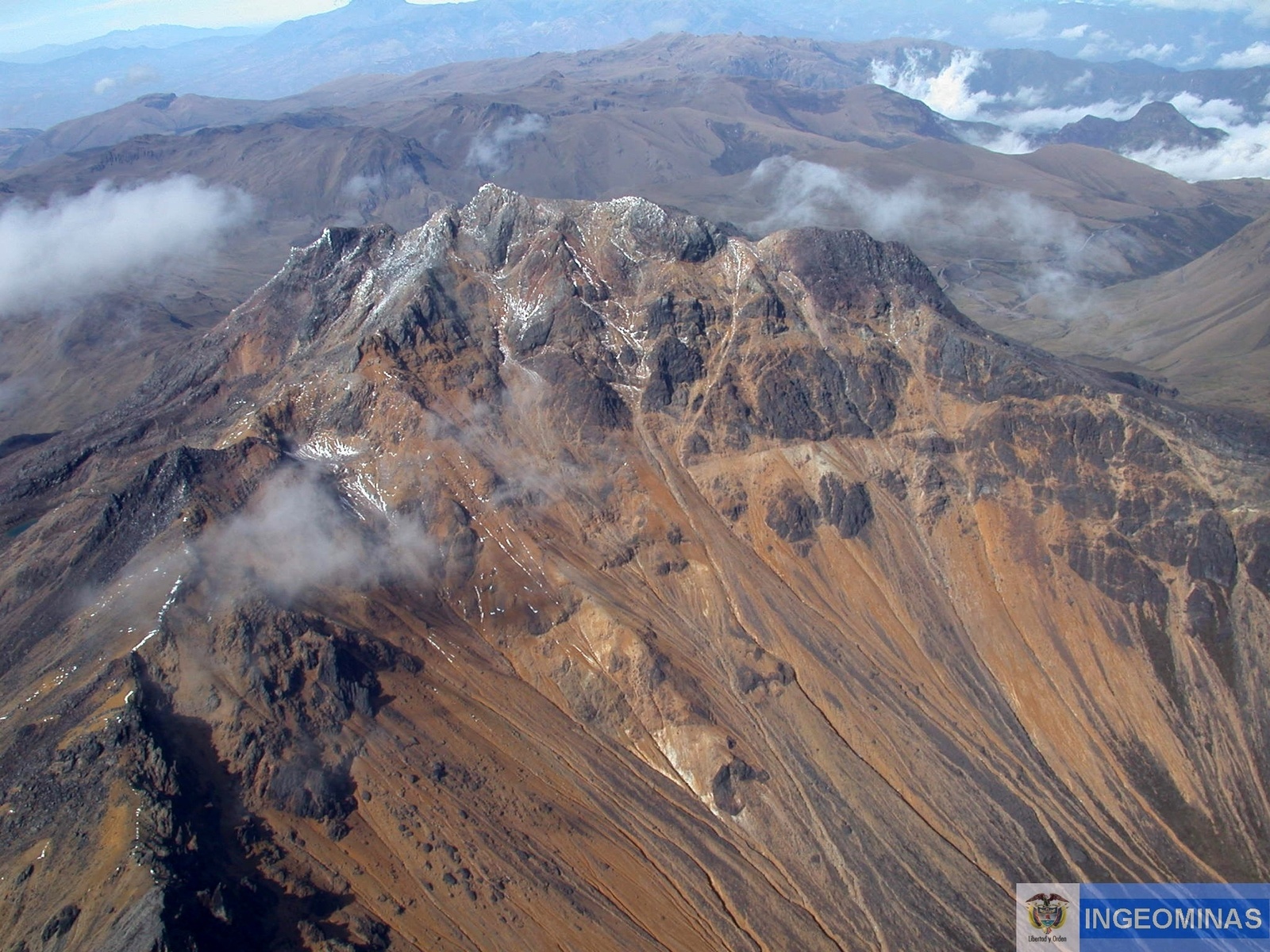
These earthquakes were located in the southwest and farthest to the southeastern areas of the Chiles volcano, with epicentral distances of up to 14 km. The depths were less than 8 km below the summit (4700 m) and the maximum local magnitude of M 1.6 on the Richter Scale.
The COLOMBIAN GEOLOGICAL SERVICE and the GEOPHYSICAL INSTITUTE OF THE NATIONAL POLYTECHNICAL SCHOOL OF ECUADOR closely monitor the evolution of this seismic activity and the volcanic phenomenon and will inform timely changes detected.
Source : SGC
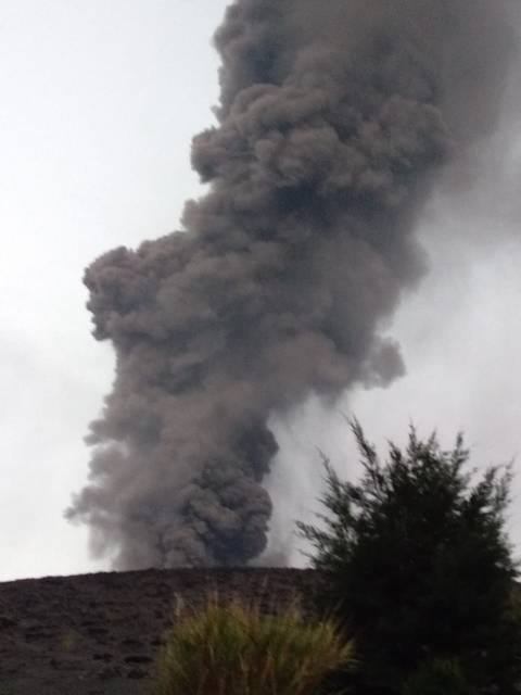
Indonesia , Agung :
VOLCANO OBSERVATORY NOTICE FOR AVIATION – VONA .
Issued: July 06 , 2018.
Volcano: Agung (264020)
Current Aviation Colour Code: ORANGE
Previous Aviation Colour Code: orange
Source: Agung Volcano Observatory
Notice Number: 2018AGU47
Volcano Location: S 08 deg 20 min 31 sec E 115 deg 30 min 29 sec
Area: Bali, Indonesia
Summit Elevation: 10054 FT (3142 M)
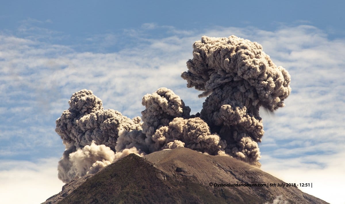
Volcanic Activity Summary:
Eruption with volcanic ash cloud at 04h49 UTC (12h49 local).
Volcanic Cloud Height:
Ash cloud not visible.
Other Volcanic Cloud Information:
–
Remarks:
Eruption recorded on seismogram with maximum amplitude 24 mm dan maximum duration 90 second.
Source : Magma Indonésie .
Photo : Øystein Lund Andersen