June 26 , 2018.
Anak Krakatau , Indonesia :
VOLCANO OBSERVATORY NOTICE FOR AVIATION – VONA.
Issued: June 25 , 2018.
Volcano: Anak Krakatau (262000)
Current Aviation Colour Code: ORANGE
Previous Aviation Colour Code: orange
Source: Anak Krakatau Volcano Observatory
Notice Number: 2018KRA02
Volcano Location: S 06 deg 06 min 07 sec E 105 deg 25 min 23 sec
Area: Lampung, Indonesia
Summit Elevation: 976 FT (305 M)
Volcanic Activity Summary:
Eruption with volcanic ash cloud at 07h42 UTC (14h42 local)
Volcanic Cloud Height:
Best estimate of ash-cloud top is around 1936 FT (605 M) above sea level, may be higher than what can be observed clearly. Source of height data: ground observer.
Other Volcanic Cloud Information:
Ash cloud moving to South.
Remarks:
Eruption recorded on seismogram with maximum amplitude 30 mm and maximum duration 14 second.
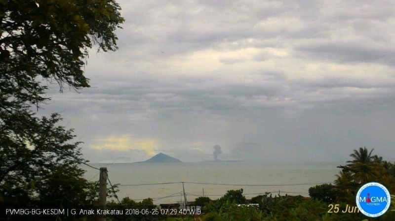
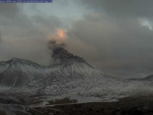
Information on the eruption of G. Anak Krakatau June 25, 2018, at 19:14
June 25, 2018 09:43
There was an eruption of G. Anak Krakatau, Lampung, on June 25, 2018 at 07:14 with a height of ash column observed at ± 1,000 m above the peak (± 1,305 m above sea level) ). The column of ash is observed in black with a strong intensity dissipating towards the North. This eruption is recorded on seismograms with a maximum amplitude of 30 mm and a duration of ± 45 seconds.
Recommendations:
The company / tourists are not allowed to approach within a radius of 1 km around the crater.
The Chief of the East Region Volcano Monitoring Mitigation Subdivision, Center for Vulnerabilities Vulnerability and Geology Mitigation (PVMBG), Geological Agency, Department of Energy and Mineral Resources, Devy Kamil Syahbana, confirmed an increase in volcanic activity of Anak Krakatau since the beginning of the week of June 18, 2018.
According to him, the eruption that has occurred is common for volcanoes entering the growth phase.
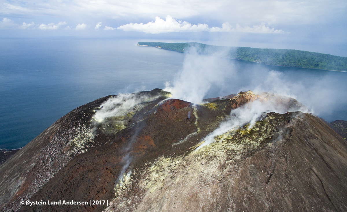
The PVMBG noted that since June 18, 2018, there has been an increase in activity with recorded volcanic and tectonic earthquakes and continuous tremors. On June 19, 2018, it was observed an increase in earthquakes, from an average of one per day to 69 per day.
In addition, it was recorded 12 low frequency earthquake. Then on June 20, 2018, there was a gust of 88 earthquakes, 11 low-frequency earthquakes, and 36 shallow volcanic earthquakes.
Finally, on June 21, 2018 there was a swarm of 49 earthquakes, 8 earthquakes of low frequency type, 50 shallow volcanic earthquakes, and 4 volcanic earthquakes. On June 22, 2018, smoke was visible over the main crater, reaching 100 to 200 meters above the summit. This smoke was gray, accompanied by volcanic ash.
Source : Centre de Volcanologie et d’Atténuation des Risques Géologiques , Magma Indonésie , senayanpost.
Photo : PVMBG , Oystein Lund Andersen.
Kilauea , Hawai :
HVO/USGS Volcanic Activity Notice
Current Volcano Alert Level: WARNING
Current Aviation Color Code: ORANGE
Previous Aviation Color Code: RED
Issued: Sunday, June 24, 2018, 8:35 PM HST
Source: Hawaiian Volcano Observatory
Location: N 19 deg 25 min W 155 deg 17 min
Elevation: 4091 ft (1247 m)
Area: Hawaii
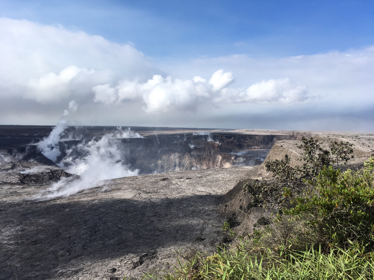
Volcanic Activity Summary: Kīlauea Volcano Summit
Episodic collapse of Kīlauea Volcano’s caldera floor continues, at times accompanied by bursts of small amounts of volcanic ash. The most recent of these occurred today at 4:12 pm.
Since late May, these collapse/explosion events have rarely produced significant ash plumes rising more than 10,000 feet above sea level where they can pose a significant hazard to aviation. For this reason, HVO is reducing the aviation color code from RED to ORANGE.
Collapse/explosion events that may produce ash plumes are expected to continue as long as subsidence is occurring at the volcano’s summit. At any time, activity could intensify producing more ash and higher ash plumes. During these events, ash may be transported downwind to impact communities.
Sulfur dioxide emissions from the volcano’s summit have dropped to levels below those measured during the high stand of the summit lava lake. Air quality in the summit area is, however, impacted by emissions from the Lower East Rift Zone.
Kīlauea Volcano Lower East Rift Zone
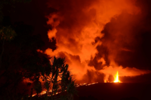
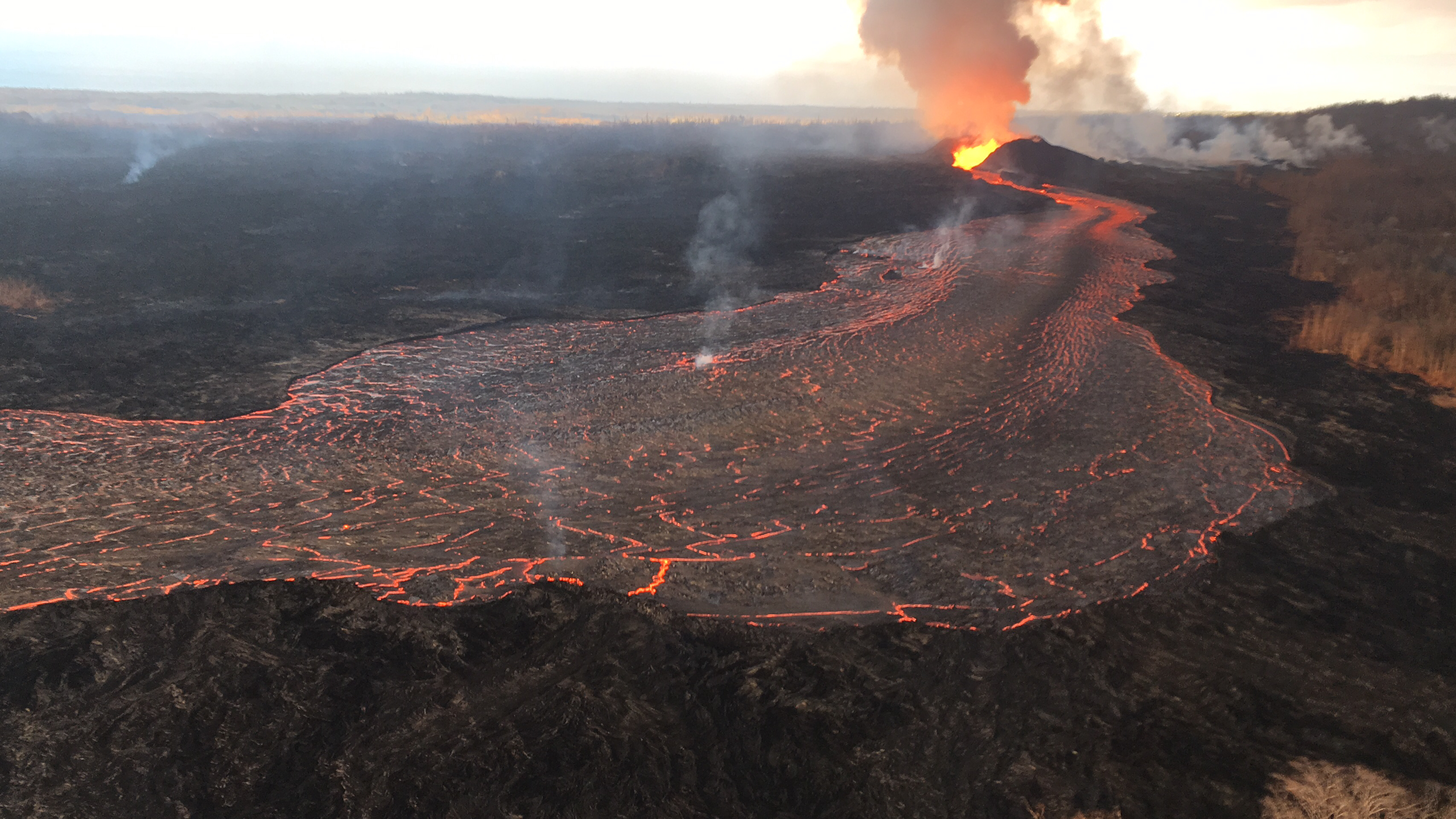
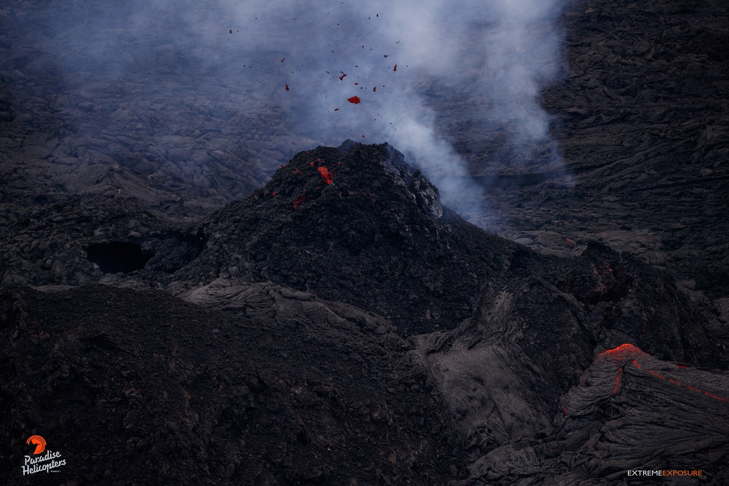
Eruption of lava and gas from the lower East Rift Zone (LERZ) continues into its seventh week. The eruption remains hazardous and therefore HVO is maintaining alert level WARNING.
The fissure 8 cone continues to feed a lava flow reaching the ocean at the Kapoho area coastline. Short-lived overflows of lava from an established channel occur periodically but generally do not travel beyond the existing flow field.
Pele’s hair and other lightweight volcanic glass fragments from the lava fountain at fissure 8 continue to fall downwind of the fissure, dusting the ground within a few hundred meters (yards) of the vent. High winds may waft lighter particles to greater distances. Residents are urged to minimize exposure to these volcanic particles, which can cause skin and eye irritation similar to volcanic ash.
Fissure 8 continues building a tephra cone and producing a robust channelized lava flow on Kīlauea Volcano’s Lower East Rift Zone.
Volcanic gas emissions remain very high in the Lower East Rift Zone. Shifting wind conditions can bring VOG to nearly all of the Island of Hawaii.
The ocean entry is a hazardous area. Interaction between lava and ocean water can produce sudden explosions of dangerous debris and steam. The growing lava delta is unstable and can slide into the sea without warning. Additionally, the interaction of lava with the ocean creates a towering plume of « laze », a corrosive seawater plume laden with hydrochloric acid and fine volcanic particles that can irritate the skin, eyes, and lungs.
Fissure 22, near PGV, resumes spattering, and some effusion of lava from its sides.
Additional ground cracking and outbreaks of lava in the area of the active fissures are possible. Residents downslope of the region of fissure vents should remain informed and heed all Hawaii County Civil Defense messages and warnings.
Monday, June 25, 2018, 12:59 PM HST (Monday, June 25, 2018, 22:59 UTC)
19°25’16 » N 155°17’13 » W,
Summit Elevation 4091 ft (1247 m)
Current Volcano Alert Level: WARNING
Current Aviation Color Code: ORANGE
Kīlauea Volcano Lower East Rift Zone
The eruption in the lower East Rift Zone (LERZ) continues with no significant change during the past 24 hours.
Fountains from Fissure 8 spatter cone continue to supply lava to the open channel with only small, short-lived overflows. The spatter cone is now 180 ft tall at its highest point, and fountains only occasionally rise above that point. The lava flow front at the coast broadened southward and is now nearly 2 miles in width. Lava is entering the sea this morning on the southern side of the flow front primarily through the open channel, but also along a 1-kilometer (0.6 mi) wide area marked by billowing laze plumes. Fissure 22 is weakly active and Fissure 16/18 was not observed this morning.
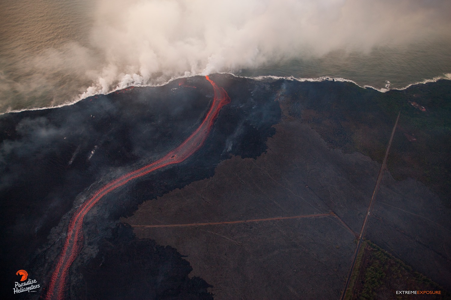
Kilauea’s east rift zone overflight: The massive channelized flow feeds the ocean entry at Kapoho, generating a large plume of laze, a mixture of steam, hydrochloric acid, and tiny bits of volcanic glass. The lighter colored lava in the lower right of the frame is from the 1955 flow.
Kīlauea Volcano Summit
At 4:12 p.m. HST on June 24, after approximately 17 hours of elevated seismicity, a collapse explosion occurred at the summit producing an ash-poor steam plume that went undetected by the weather radar. Visual observations suggested the plume rose less than 2000 ft above the caldera before drifting downwind to the southwest. The energy released by the event was equivalent to a magnitude 5.3 earthquake. Seismicity dropped abruptly from a high of 25-35 earthquakes per hour (many in the magnitude 2-3 range) prior to the collapse explosion down to less than 10 per hour afterwards. Within 3 hours seismicity began to creep up again averaging about 30 earthquakes per hour by daybreak (June 25). Inward slumping of the rim and walls of Halemaʻumaʻu continues in response to ongoing subsidence at the summit.
Source : HVO
Photos : USGS , Bruce Omori.
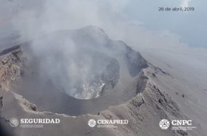
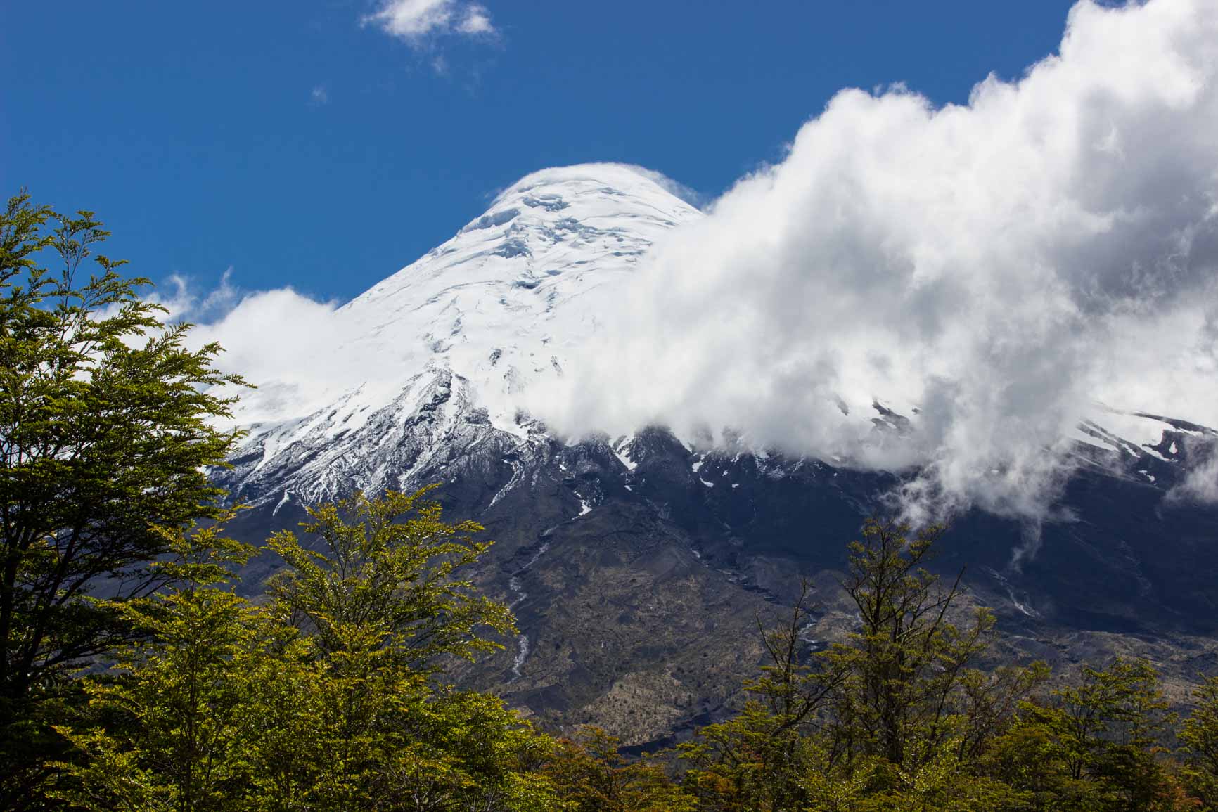
Osorno , Chile :
Special Report on Volcanic Activity (REAV)
Lake District. June 23, 2018, 11:00 am (local time).
The National Geological and Mining Service (SERNAGEOMIN) of Chile publishes the following information obtained by the monitoring teams of the National Volcanoes Surveillance Network (RNVV), processed and analyzed at the Volcanological Observatory of the Southern Andes (OVDAS):
On Saturday, June 23, 2018 at 10:30 local time (14:30 GMT), monitoring stations near the Osorno volcano recorded one (1) earthquake associated with rock fracturing (volcano-tectonic type) .
The location obtained was as follows:
TIME OF ORIGIN: 10:30 (GMT-4)
LATITUDE: 41 ° 5,37 ‘South
LONGITUDE: 72 ° 30.38 ‘West
DEPTH: 2.9 km
LOCAL MAGNITUDE: M3,0
Crater distance: 1.9 North-West
OBSERVATIONS
At the time of publication of this report, no new replicas have been recorded. There is no report from the authorities or the community in general, about the perceptions of the earthquake in neighboring areas.
Volcanic technical warning is maintained at the YELLOW level,
The Sernageomin continues with online monitoring, and will inform about possible changes in volcanic activity in the region.
Source : Sernageomin
Sierra Negra , Ecuador / Galapagos :
Special Report Volcán Sierra Negra Nº 5 – 2018
Increased seismic activity in the last hours
The Sierra Negra volcano (0.81 ° S, 91.13 ° W, 1124 m), located in the province of Galapagos, 23 km northwest of Puerto Villamil and 90 km northeast of Puerto Ayora , has presented a significant seismic activity since mid-2016, and also presents a large deformation as indicated in the special report DOSSIER SIERRA NEGRA N.- 4.
![]()
In the last 12 hours, the Sierra Negra volcano has experienced an increase in seismic activity. The largest recorded event occurred at 6:24 am Galapagos time (Ecuador time -1 pm), with a magnitude of M4.2. According to reports from the Galapagos National Park, this event was felt in the area known as El Cura and San Joaquín (site to the northeast of the volcano). The increase in seismic activity could be a precursor of eruptive activity. It should be noted that it is not possible to predict when an eruption will occur, nor its exact location, nor its size.
The IGEPN continues volcanic monitoring and will inform if changes in the internal or external activity of the volcano are observed.
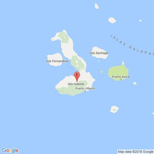
Figure 1. Location of the magnitude 4.2 earthquake on the Sierra Negra volcano (source IGEPN 06/22/2018).
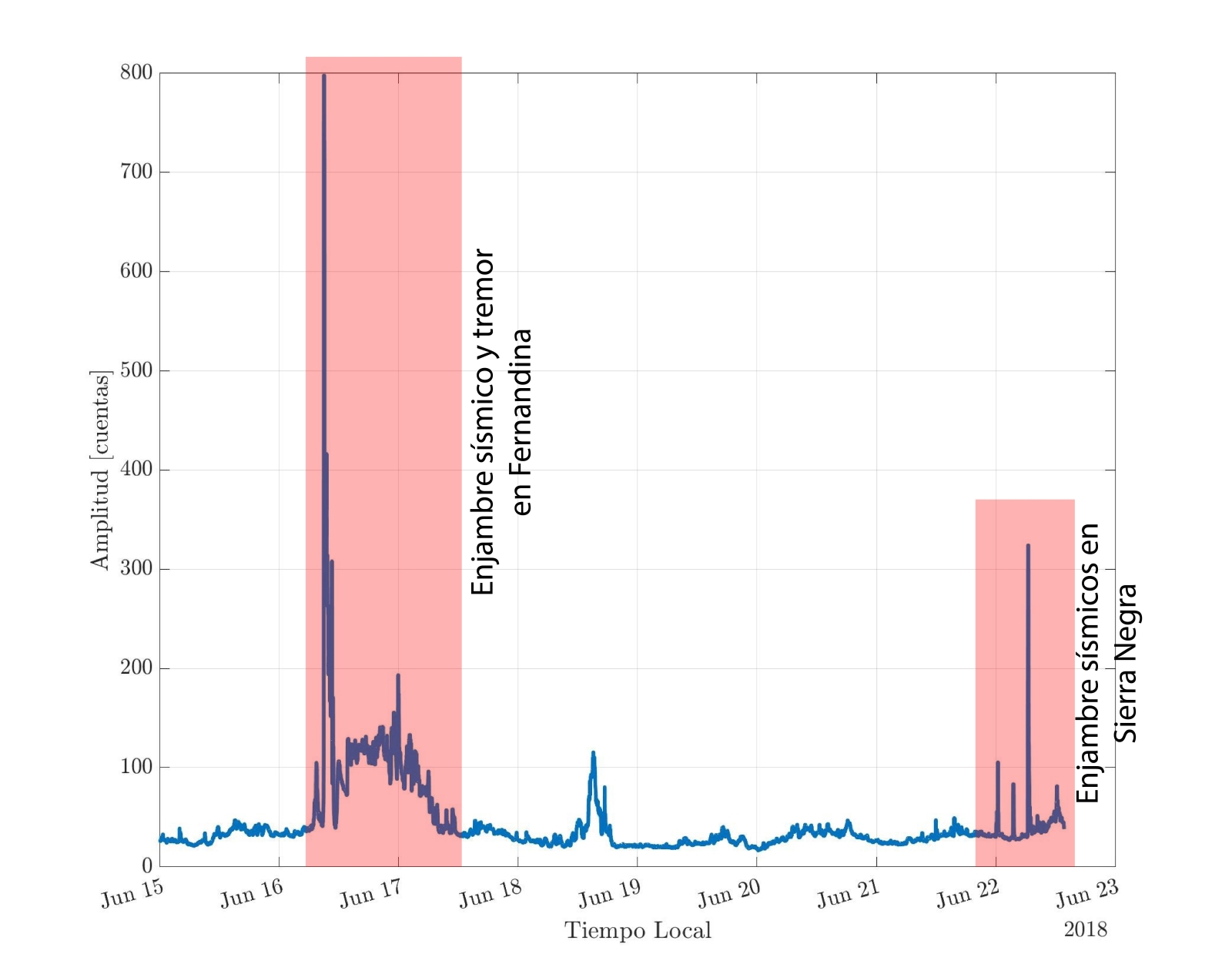
Figure 2. Recorded increase in seismic activity at VCH1 at the northeastern limit of the Sierra Negra volcano caldera.
Source : SV, BB, SH
Institute of Geophysics
National Polytechnic School
Sabancaya , Peru :
An average of 29 explosions / day was recorded. The earthquakes associated with the rise of the magma (type Hybrids) remain very weak in number and energy.
The eruptive columns of gas and ash reached a maximum height of 1800 m above the crater. The dispersion of these materials occurred within a radius of about 30 km, mainly in the Southeast, South and East directions.

The volcanic gas (SO2) flow recorded on June 21st has a maximum value of 4900 tonnes / day, a value considered large.
The deformation of the surface of the volcanic building does not present any significant variations.
The MIROVA satellite system recorded 11 thermal anomalies, with values between 1 MW and 60 MW VRP (Radiated Volcano Power).
In general, eruptive activity maintains moderate levels. No significant changes are expected for the following days.
Source : IGP