June 11 , 2018.
Pu’u ‘Ō’ō / Kilauea , Hawai :
Kilauea – 2018-06-10 13:06:22 At 12:51 AM HST,
another small explosion occurred at Kīlauea’s summit; equivalent magnitude was M5.4; event widely felt in Volcano area; based on past events, minor ashfall may occur on the south part of the island.
Saturday, June 9, 2018, 10:37 PM HST (Sunday, June 10, 2018, 08:37 UTC)
19°25’16 » N 155°17’13 » W,
Summit Elevation 4091 ft (1247 m)
Current Volcano Alert Level: WARNING
Current Aviation Color Code: RED
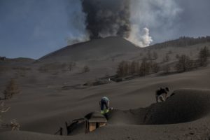
Kīlauea Volcano Lower East Rift Zone
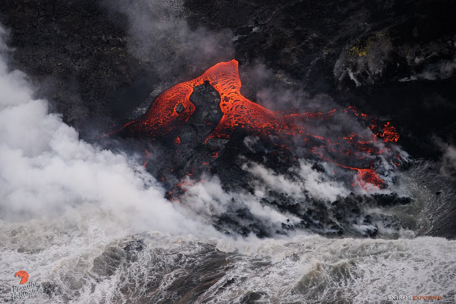
Vigorous eruption of lava continues from the lower East Rift Zone (LERZ) fissure system in the area of Leilani Estates.
Lava fountaining from Fissure 8 continued throughout the day, topping out at about 200 feet in height. Today’s evening observation flight reported no significant changes in the fountain or in the channels carrying lava to the ocean at Kapoho. Minor flows overtopping the channel levees have been observed today, but no significant breakouts have occurred. The ocean entry area continues to produce robust plumes. Observers also noted vigorous convection taking place up to 0.9 miles offshore from the entry points.
Minor activity at Fissures 16/18 continued.
Pele’s hair and other lightweight volcanic glass from fountaining of Fissure 8 are falling downwind of the fissure and accumulating on the ground within Leilani Estates. High winds may waft lighter particles to greater distances. Residents are urged to minimize exposure to these volcanic particles, which can cause skin and eye irritation similar to volcanic ash.
HVO field crews are on site tracking the fountains, lava flows, and spattering from Fissure 8 as conditions allow and are reporting information to Hawaii County Civil Defense. Observations are also collected on a daily basis from cracks in the area of Highway 130; no changes in temperature, crack width, or gas emissions have been noted for several days.
Volcanic gas emissions remain very high from Fissure 8 eruptions. Trade wind conditions are expected to bring vog to the south and west sides of the Island of Hawaii.
Magma continues to be supplied to the lower East Rift Zone. Seismicity remains relatively low in the area with numerous small magnitude earthquakes and low amplitude background tremor. Higher amplitude tremor is occasionally being recorded on seismic stations close to the ocean entry.
Additional ground cracking and outbreaks of lava in the area of the active fissures are possible. Residents downslope of the region of fissures should heed all Hawaii County Civil Defense messages and warnings.
USGS/HVO continues to monitor the lower East Rift Zone activity 24/7 in coordination with Hawaii County Civil Defense.
Kīlauea Volcano Summit
Minor ash emissions and degassing continue at the summit. Seismicity dropped significantly after the explosive eruption this morning but has slowly risen through the day. If the recent pattern of these explosions is repeated we expect the next small explosion to occur within 24 hours . Inward slumping of the rim and walls of Halema`uma`u continues in response to ongoing subsidence at the summit.
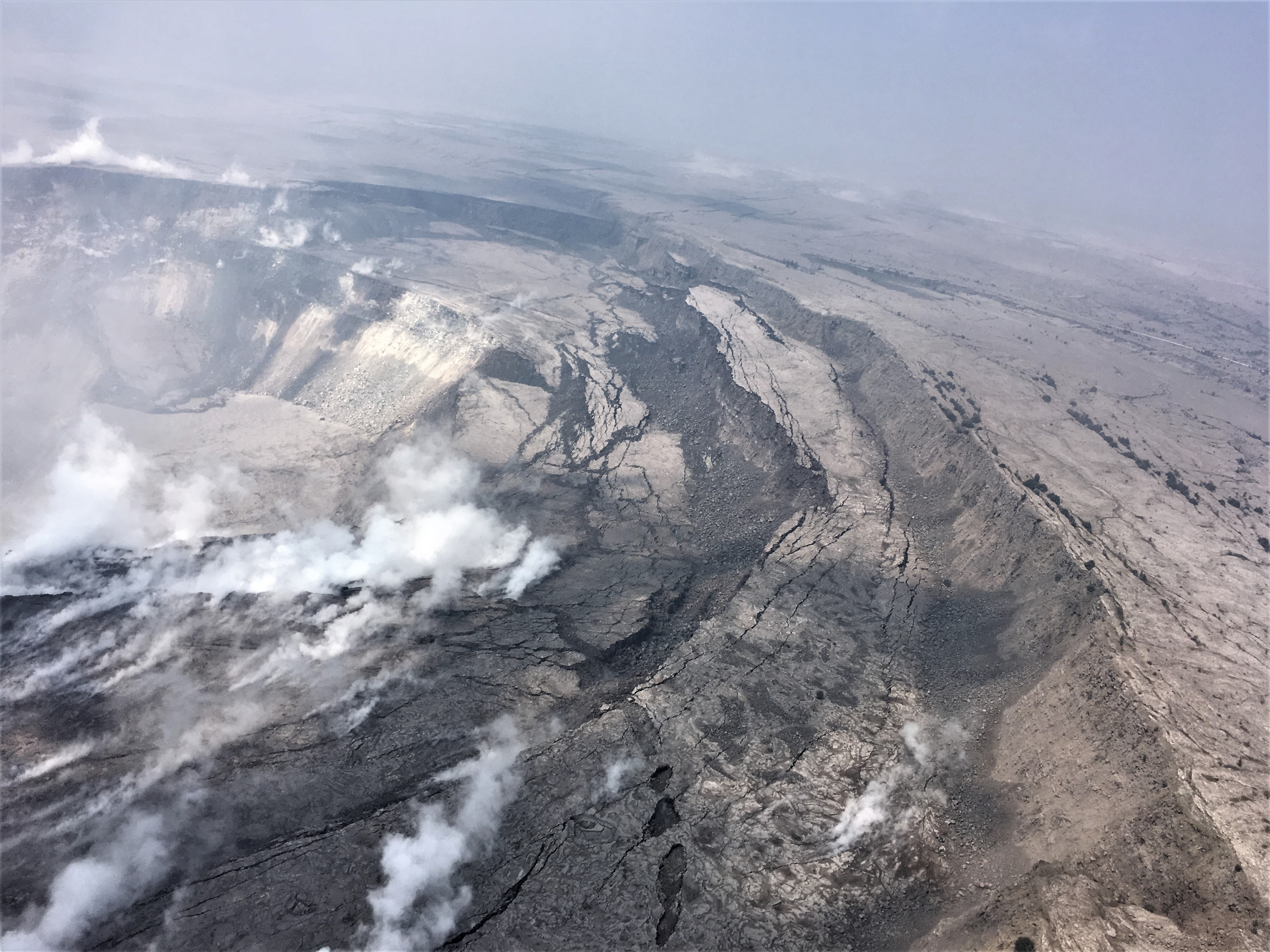
Cracking and slumping of the Halema‘uma‘u crater walls are clearly evident in this aerial view captured during HVO’s overflight of Kīlauea’s summit this morning. Steam plumes have been rising from within the crater, as well as from cracks adjacent to the crater.
Sulfur dioxide emissions from the volcano’s summit have dropped to levels that are about half those measured prior to the onset of the current episode of eruptive activity. This gas and minor amounts of ash are being transported downwind, with small bursts of ash and gas accompanying intermittent explosive activity.
Sunday, June 10, 2018, 8:56 AM HST (Sunday, June 10, 2018, 18:56 UTC)
Kīlauea Volcano Lower East Rift Zone
Vigorous eruption of lava continues from the lower East Rift Zone (LERZ) fissure system in the area of Leilani Estates.
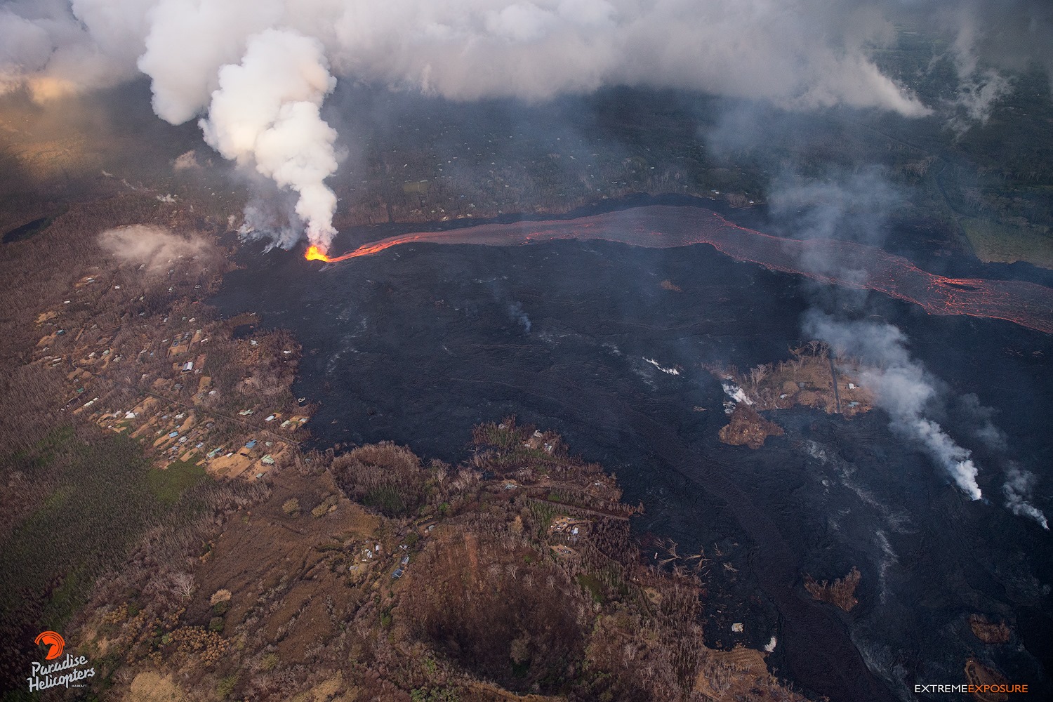
Overnight, lava fountains from Fissure 8 reached heights of 130-180 feet, feeding a strong channel to the northeast and then east that experienced minor small levee overflows. Near the Four Corners region the channel was incandescent and flowing. Yesterday’s measurements show that gas emissions have nearly doubled, possibly indicating an increase in eruption rate from Fissure 8. The morning overflight revealed that the fountains and channels continue to erupt and transport lava to the ocean entry which was one large plume. Offshore of this ocean entry, there is an upwelling of ocean water heated by lava flowing on the ocean floor.
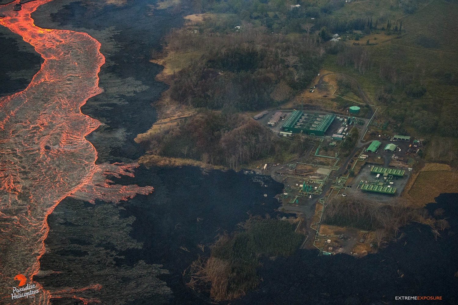
Kilauea’s east rift zone overflight: Another view of the overflowing perched channel, sending lava toward PGV
Minor lava activity at Fissures 16/18 continued.
Kīlauea Volcano Summit
A small explosion occurred at Kilauea’s summit at 12:51 AM HST — about 20 hours since the previous event. Seismicity dropped immediately after the explosion and remains low at this time, but based on past trends we expect earthquake rates to increase over the course of the day. Inward slumping of the rim and walls of Halema`uma`u continues in response to ongoing subsidence at the summit.
Sunday, June 10, 2018, 4:01 PM HST (Monday, June 11, 2018, 02:01 UTC)
Kīlauea Volcano Lower East Rift Zone
Vigorous eruption of lava continues from the lower East Rift Zone (LERZ) fissure system in the area of Leilani Estates.
Fissure 8 now consists of three closely-spaced lava fountains, the tallest of which reached heights of 130-180 feet, feeding a strong channel to the northeast and then east to the ocean entry. During the day, minor spillovers have dribbled over the Fissure 8 channel levees but have generally stalled before reaching ground not covered by previous lava flows. Yesterday’s measurements show that gas emissions from the fissure system have nearly doubled, possibly indicating an increase in eruption rate from Fissure 8.
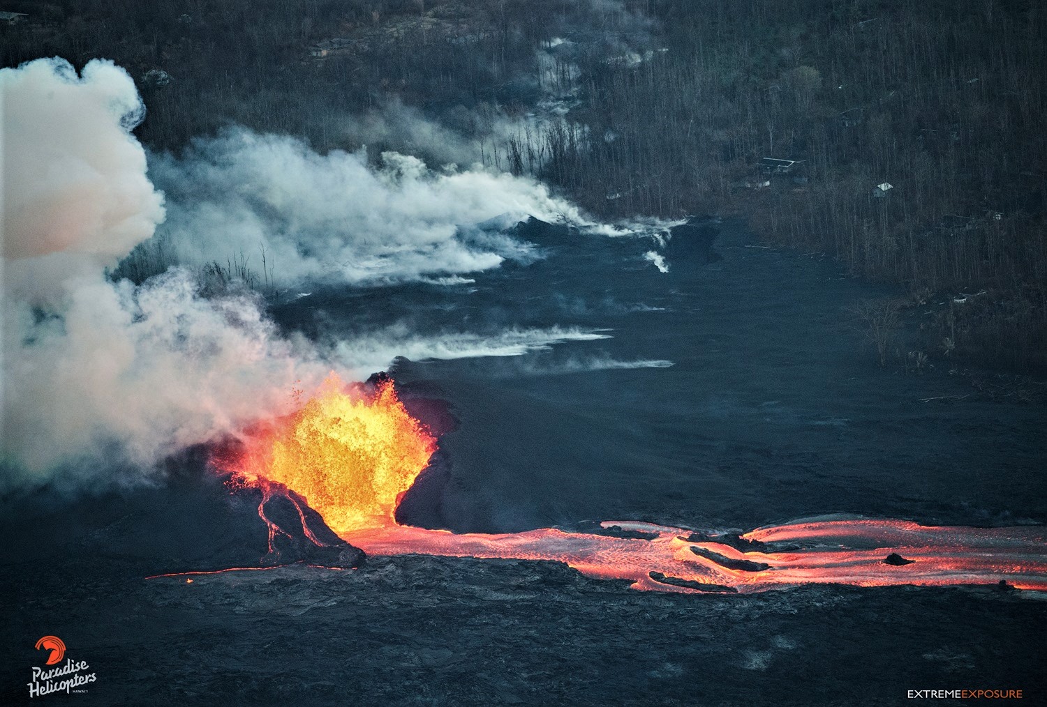
Kilauea’s east rift zone overflight: While overall height of the fountaining had decreased, the width increased, and possibly the output as well. The homes in the Leilani Estates subdivision behind the cone, lends some sense of scale to this scene.
Minor lava activity at Fissures 16/18 continued.
Kīlauea Volcano Summit
There have been no ash emissions since dawn; however, wind has remobilized ash in the caldera. Seismicity and earthquake rates have increased over the course of the day. Inward slumping of the rim and walls of Halema`uma`u continues in response to ongoing subsidence at the summit.
Sulfur dioxide emissions from the volcano’s summit have dropped to levels that are about half those measured prior to the onset of the current episode of eruptive activity. This gas and minor amounts of ash are being transported downwind, with small bursts of ash and gas accompanying intermittent explosive activity.
Source : HVO
Photo : HVO , Bruce Omori .
Vidéo : USGS
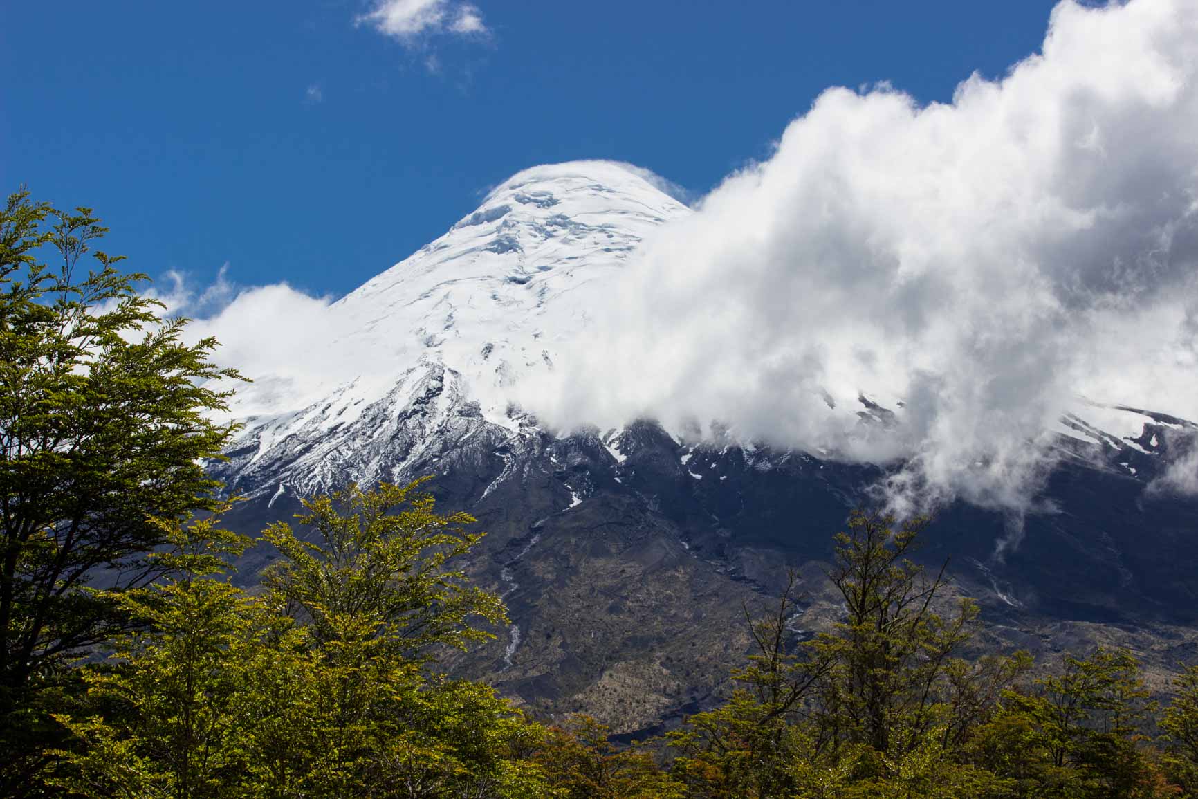
Osorno , Chile :
During this period, 132 seismic events were recorded, of which 97 were classified as long-term events (LP) in relation to fluid dynamics within the volcano and / or glacial dynamics. The larger magnitude event had reduced displacement values (DRC) equal to 6.3 cm2. In addition, 35 volcano-tectonic (VT) events associated with fracturing of rigid materials were classified. The event of greatest energy had a local magnitude (ML) equal to M 2.2 and was located 1.6 km west – northwest of the crater, at a depth of 3.9 km.
In order to improve the monitoring network of this volcano, in the first half of May, the Interlagos IP room became operational. For the second half of May, the seismological station of Licarayen and the IP chambers of Cascadas and Llanquihue were operational.
No emissions of sulfur dioxide (SO2) to the atmosphere in the volcano area have been reported, according to data published by the Ozone Monitoring Instrument (OMI) Sulfur Dioxide Group (http: / /so2.gsfc.nasa.gov/) and the National Satellite Environment and Information Data (NESDIS) (http: // satepsanoine nesdis.noaa.gov) ..
No thermal warnings have been reported in the volcano-associated area, according to data processed by Infrared, a means of observing volcanic activity (Mirova) (http://www.mirovaweb.it/) and MODVOLC (http : //modis.higp.hawaii.edu/).
Volcano-tectonic seismicity continued to be recorded beneath the volcano, concentrated under the North-North-West (NNW) flank of the crater, suggesting the onset of processes of greater instability of the volcanic system.
For the above, the volcanic alert is maintained at the level:
YELLOW LEVEL: Changes in the behavior of volcanic activity – Probable time for an eruption: WEEKS / MONTH.
Source : Sernageomin.
Photo : Filmssurlepouce
Fuego , Guatemala :
SPECIAL BEFGO VULCANOLOGICAL BULLETIN # 53-2018
Strong lahars in the ravines SECA, MINERAL, NIAGARA, TANILUYÁ and CENIZA, Fuego volcano.
Type of activity: Vulcanian
Morphology: Composite Stratovolcan
Location: 14 ° 28’54˝ Latitude N; 90 ° 52’54˝Longitude W.
Height: 3 763msnm.
Guatemala June 10, 2018, 3:15 pm (local time)
Due to continuous rains in the Fuego Volcano region, powerful lahars are generated from the Seca, Mineral, Niagara, Taniluyá and Ceniza ravines, tributaries of the Pantoja River and Achiguate respectively, which may again generate cut communication routes between the communities of Sangre de Cristo, Finca Palo Verde, Panimaché, Morelia and Santa Sofía to the municipalities of San Pedro Yepocapa and Santa Lucia Cotzumalguapa, which prevents transit through the main access roads in these communities.
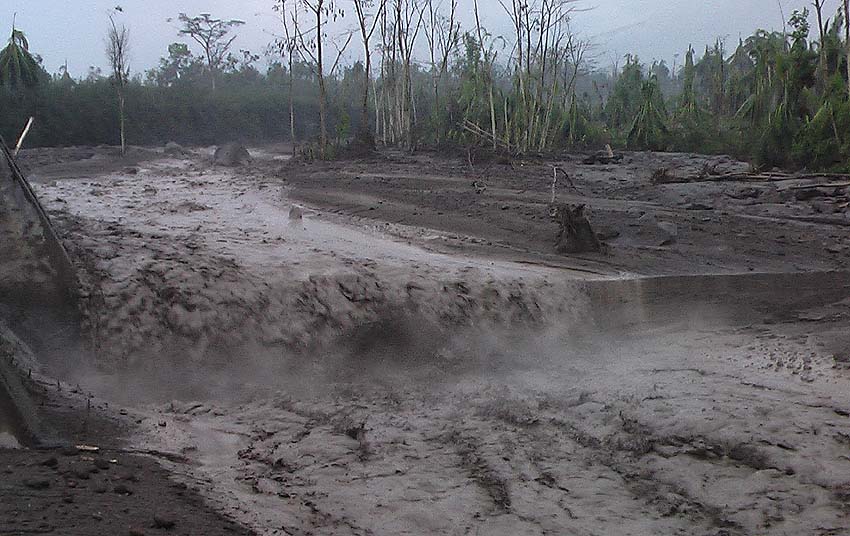
Its dimensions are 35 meters wide and 3 meters high, which causes vibrations in its path. The materials of this lahar contain a lot of fine pasty material, blocks up to 1 meter in diameter. He slides tree trunks and branches in his path. Due to the last eruptions, the lahar descending is hot, smelling of sulfur and steam emanating from it because of its temperature.
Due to the rains that are generated at the top of the volcano, the descent of lahars through the ravines of Trinidad, El Jute, Las Lajas and Honda is likely to occur.
Source : Insivumeh.
Great Sitkin, Aleutian Islands:
VOLCANO OBSERVATORY NOTICE FOR AVIATION (VONA) .
Issued: June 10 , 2018
Volcano:Great Sitkin (VNUM #311120)
Current Color Code:YELLOW
Previous Color Code:GREEN
Source:Alaska Volcano Observatory
Volcano Location:N 52 deg 4 min W 176 deg 6 min
Area:Aleutians
Summit Elevation:5709 ft (1740 m)
Volcanic Activity Summary:
Earthquake activity at Great Sitkin Volcano has been elevated over the past five days, and earlier today at 11:39 AKDT (19:39 UTC), a signal that may represent a short-lived steam explosion was detected by seismic data. AVO is thus raising the Aviation Color Code and Alert Level to YELLOW/ADVISORY.
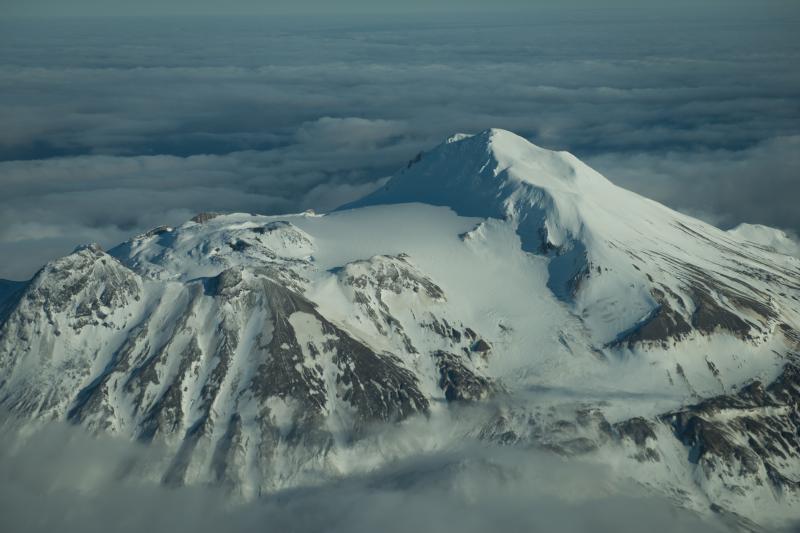
Great Sitkin Volcano is monitored by a five-station seismic network on Great Sitkin Island and with additional seismic stations on the nearby islands of Igitkin, Adak, Kagalaska, and Kanaga. A six-element infrasound array to detect explosions (atmospheric pressure waves) was installed on Adak Island in June, 2017, although it is currently (June 2018) only partly operational. AVO also uses satellite imagery to monitor Great Sitkin Volcano.
Volcanic cloud height:not applicable
Other volcanic cloud information:Unknown
Remarks:
Great Sitkin Volcano is a basaltic andesite volcano that occupies most of the northern half of Great Sitkin Island, a member of the Andreanof Islands group in the central Aleutian Islands. It is located 43 km (26 miles) east of the community of Adak. Great Sitkin erupted at least three times in the 20th century, most recently in 1974. That eruption produced at least one ash cloud that likely exceeded an altitude of 25,000 ft above sea level. A poorly documented eruption occurred in 1945, also producing a lava dome that was partially destroyed in the 1974 eruption. A seismic swarm occurred from July 2016 through the end of 2017.
Source : AVO
Photo : Roger Clifford. Novembre 2012