June 06 , 2018.
Pu’u ‘Ō’ō / Kilauea , Hawai :
Monday, June 4, 2018, 10:21 PM HST (Tuesday, June 5, 2018, 08:21 UTC).
19°25’16 » N 155°17’13 » W,
Summit Elevation 4091 ft (1247 m)
Current Volcano Alert Level: WARNING
Current Aviation Color Code: RED
Kīlauea Volcano Lower East Rift Zone
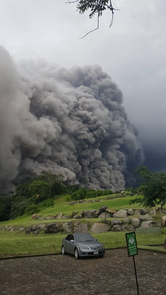
Vigorous eruption of lava continues from the lower East Rift Zone (LERZ) fissure system in the area of Leilani Estates and Lanipuna Gardens.
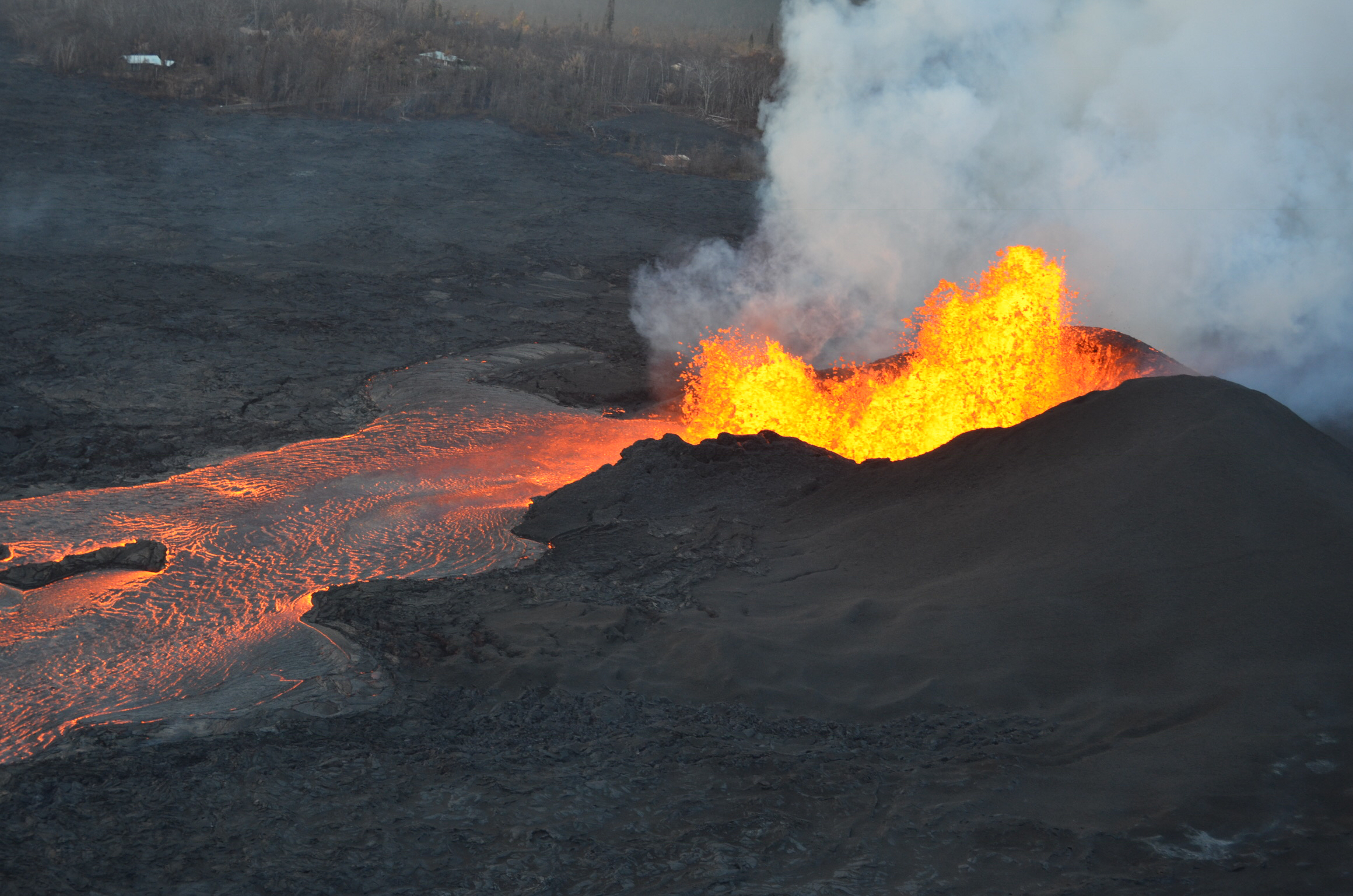
Fountaining at Fissure 8 continues to feed a robust channel transporting lava to the northeast along Highway 132 and east to the ocean entry in Kapoho Bay. Multiple observations from field crews and overflights suggest the Fissure 8 fountain is less vigorous this evening, with maximum heights of 130-160 feet. As of early evening, lava was filling Kapoho Bay, extending out approximately 750 yards from shore. A laze plume is blowing inland from the ocean entry but is dissipating quickly. The lava breakout on the north side of the Kapoho cinder pits continues to be stalled southeast of the intersection of Railroad Avenue and Cinder Road. A lava breakout from the south margin of the flow near the intersection of Highway 132 and Railroad Avenue has completely encircled the Green Lake cone.
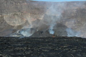
Sluggish lava flows are present in the vicinity of Fissure 18, and there are reports of spattering at Fissures 6/13. All other fissures are inactive.
Pele’s hair and other lightweight volcanic glass from high fountaining of Fissure 8 are falling downwind of the fissure and accumulating on the ground within Leilani Estates. Winds may waft lighter particles to greater distances. Residents are urged to minimize exposure to these volcanic particles, which can cause skin and eye irritation similar to volcanic ash.
HVO field crews are on site tracking the fountains, lava flows, and spattering from multiple fissures as conditions allow and are reporting information to Hawaii County Civil Defense.
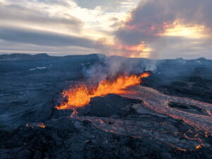
Lava fountains continue at fissure 8, although overnight USGS field crews reported reduced fountain heights. The lava fountain has built a 35 m (115 ft) high spatter cone, as wells as an actively-growing spatter rampart on its eastern side. The lava channel leading from the cone was filled to the top of its levees at the time of this photo.
Volcanic gas emissions remain very high from the fissure eruptions. Trade wind conditions are bringing vog to the south and west sides of the Island of Hawaii. Afternoon easterly winds may bring vog to communities in the Volcano area.
Kīlauea Volcano Summit
Earthquake activity at the summit was low after Sunday’s small explosion, but has slowly increased since that time. Levels are approaching those of Sunday early afternoon, before the most recent small explosion. Inward slumping of the rim and walls of Halema`uma`u continues in response to persistent subsidence. We expect that earthquake rates will increase in the coming hours and culminate in another small explosion, perhaps within the next day, following the pattern of the past few weeks.
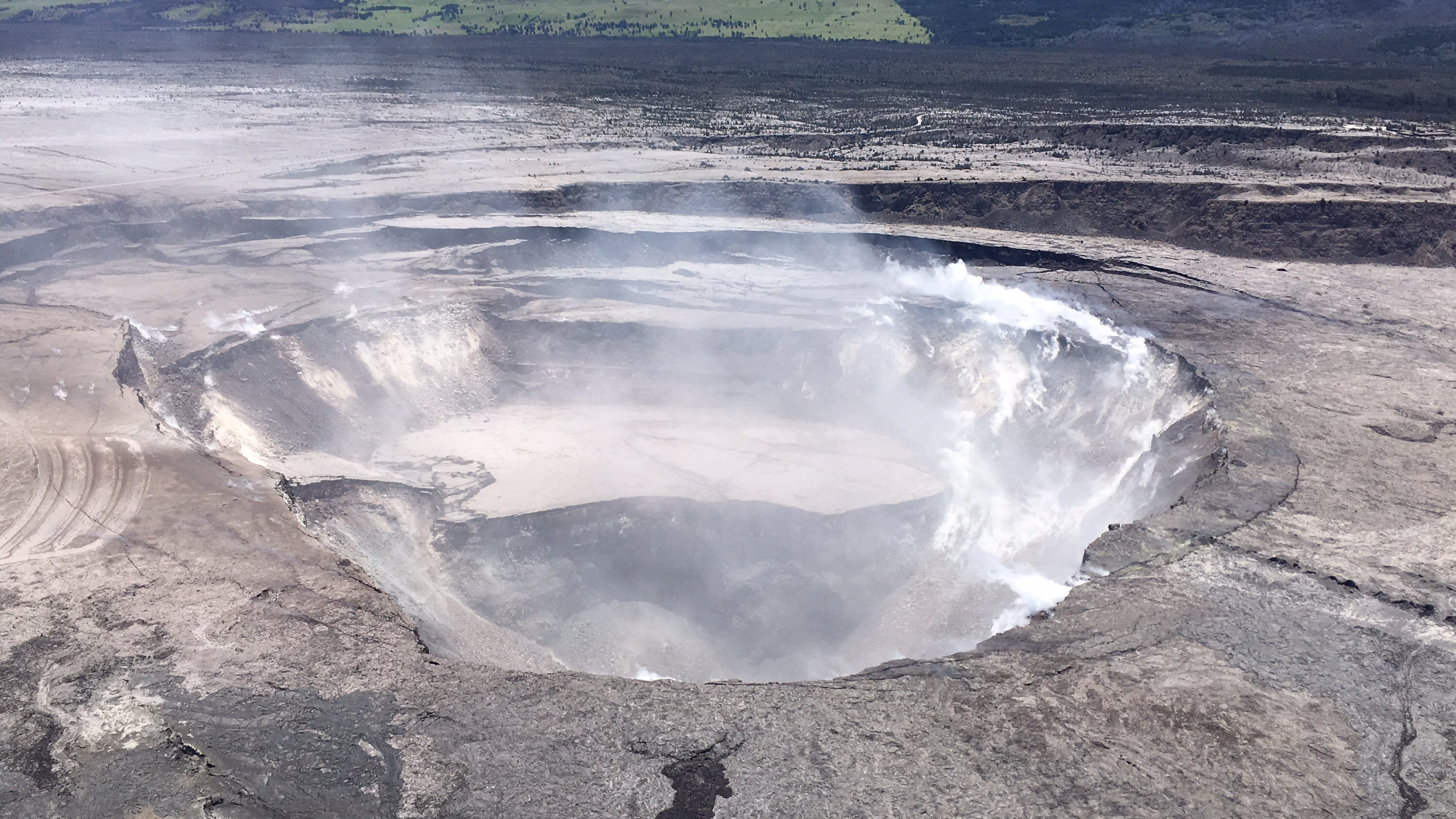
HVO scientists captured this aerial view of a much-changed Halema‘uma‘u during their overflight of the summit this afternoon. Explosions and collapse within Halema‘uma‘u have enlarged the crater (foreground) that previously hosted the summit lava lake, and the far rim of Halema‘uma‘u has dropped with continued summit deflation. The parking area for the former Halema‘uma‘u Overlook (closed since early 2008 due to volcanic hazards) can be seen to the left of the crater.
Over the last week, sulfur dioxide passively degassing from the volcano’s summit has decreased, but emission rates remain high enough to impact air quality in downwind regions. Additional bursts of gas released with intermittent explosive activity are also transported downwind and may temporarily affect air quality as well.
Tuesday, June 5, 2018, 8:10 AM HST (Tuesday, June 5, 2018, 18:10 UTC)
Kīlauea Volcano Lower East Rift Zone
The intensity of lava fountaining at Fissure 8 declined overnight, and fountain height is fluctuating between 130 and 160 feet (not far above the top of the cone that has formed over the past week). Fissure 8 continues to feed a channel transporting lava to the northeast along Highway 132 and east to the ocean entry in Kapoho Bay.
HVO’s 6:30 AM HST overflight confirmed that lava completely fills Kapoho Bay, extending 0.7 miles from the former coastline. To the south, lava is entering the water at the Vacationland tidepools, having inundated most of that subdivision. To the north, lava has covered all but the northern part of Kapoho Beach Lots. The northernmost lobe of the Fissure 8 flow, in the Noni Farms Road area, advanced downslope about 200 yards overnight.
No other fissure vents showed significant activity this morning.
Kīlauea Volcano Summit
High levels of earthquake activity occurred for most of Monday night and into Tuesday morning. A small explosion, with an equivalent earthquake magnitude of M5.5, occurred at 4.32 AM HST, generating a small plume that rose about 1000 feet above the summit. Since the small explosion, summit seismicity has been low, following the pattern of previous events. Inward slumping of the rim and walls of Halema`uma`u continues in response to ongoing subsidence of the summit.
Locally felt earthquakes are expected to continue and further ash explosions are likely.
Tuesday, June 5, 2018, 4:54 PM HST (Wednesday, June 6, 2018, 02:54 UTC)
Kīlauea Volcano Lower East Rift Zone
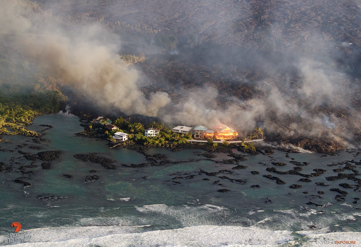
Lava fountaining at Fissure 8 is continuing with fountain heights reported at 150-180 feet. This eruptive activity continues to feed a channel transporting lava to the northeast along Highway 132 and east to the ocean entry in Kapoho Bay area. Minor breakouts along the channelized flow field continue to occur but all have been very small and have stagnated before travelling any significant distance. HVO’s mid-day overflight showed the fissure 8 flow has completely filled Kapoho Bay and formed a lava delta extending 0.8 miles out from the former coastline. The northernmost lobe of the Fissure 8 flow, in the Noni Farms Road area, is advancing very slowly to the northeast. No other fissure vents showed significant activity at this time.
Kīlauea Volcano Summit
Earthquake activity dropped after this morning’s small explosion and is now slowly rising following the pattern of previous events of this type. Monitoring data show that subsidence at the summit crater continues. The mid-day observation flight showed continued Inward slumping of the rim and walls of Halema`uma`u in response to subsidence at the summit.
Source : HVO .
Photos : USGS, Bruce Omori.
Vidéo : USGS , Mick Kalber.
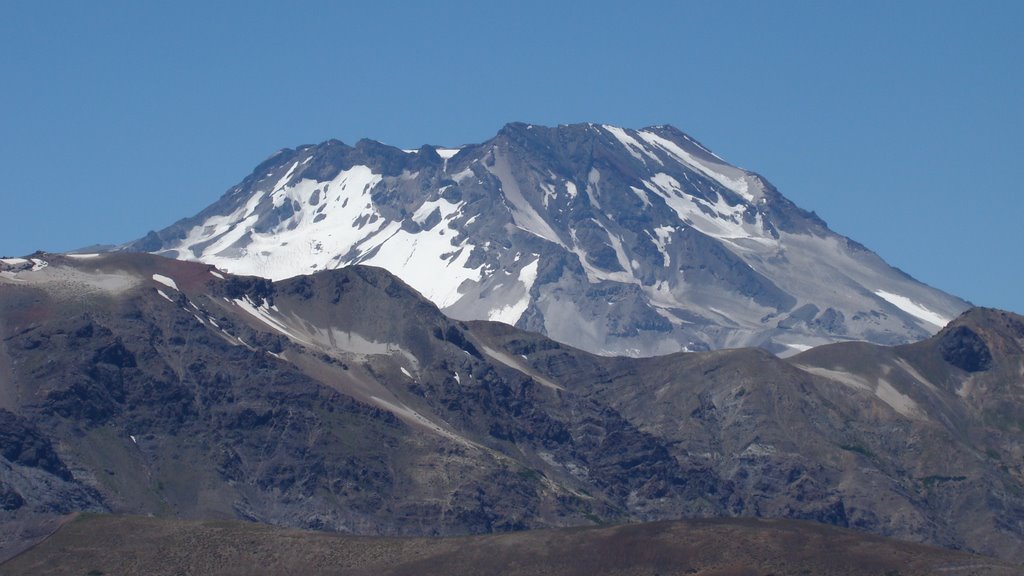
Descabezado Grande , Chile :
Special Report on Volcanic Activity (REAV)
Del Maule Region, Descabezado volcano, June 4, 2018, 13:05 Local time (Continental Chile).
The National Service of Geology and Mines of Chile (Sernageomin) announces the following PRELIMINARY information, obtained through the monitoring equipment of the National Network of Volcanoes Surveillance (RNVV), processed and analyzed at the Volcanological Observatory of the Andes. South (OVDAS):
Today, Monday, June 4 at 12:27 local time (16:27 GMT), the monitoring stations installed near the Descabezado volcano recorded an earthquake associated with rock fracturing (Volcano-Tectonics).
The characteristics of the earthquake after its analysis are as follows:
Original time: 12:27 local time (16:27 GMT)
Latitude: 35.570 ° S
Longitude: 70 751 ° W
Depth: 3.0 km
Magnitude: 3.1 (ML)
OBSERVATIONS
No replies were recorded after the recorded earthquake registration
Source : Sernageomin.
Fuego , Guatemala :
I can not not post this full common sense remark of Dr. Boris Behncke:
I do not think, however, that jokes should be made about the idiocy of those who were surprised by the unusually large pyroclastic flows during the eruption of the Fuego volcano in Guatemala two days ago. The fact is that the scale of the event far exceeded that of the dozens and dozens of modest paroxysmal episodes that had occurred on the same volcano over the last 20 years.. In addition, the presence of clouds on the volcano made the development of the activity invisible, and so everyone thought it was another climax like those before.
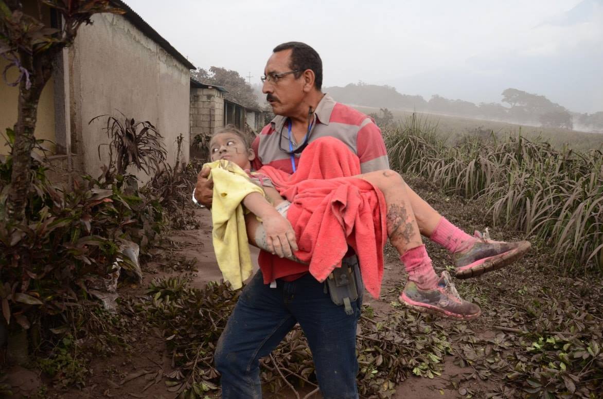
Many of the victims of the eruption were not curious and spectators, but (very poor) inhabitants of the villages at the foot of the volcano, and among them there were also many children. People who live by working in the plantations around the Fuego, with little means to know the dangerousness of the pyroclastic flows and lahar (flow of mud) of this volcano. To realize the reality of these people and the impact on them of the eruption, I invite you to look at the face of this poor little girl, burned terribly on the hands and legs (recognizable by the swelling of these areas ) by the heat of a pyroclastic flow. Fortunately, this girl should be able to recover completely, but for many others, it was much worse.
SPECIAL BEFGO VULCANOLOGICAL BULLETIN # 38-2018 Guatemala 05 June 2018, 19h55 (local time)
Pyroclastic flows in the ravines Las Laras and Jute.
Type of activity: Vulcanian
Morphology: Composite stratovolcano
Location: 14 ° 28’54˝ Latitude N; 90 ° 52’54˝Longitude W.
Height: 3 763msnm.
As reported the activity of the Fuego volcano, increased from 14 hours, this generated moderate and some strong explosions, with ashes rising to 5000 meters and scattered in the Northeast direction.
From 19:28 (local time) a new pyroclastic flow was generated towards the ravine of Las Lajas, so the precautions of use must be taken. Due to cloudiness, its movement could not be observed.
Sources : Dr Boris Behncke , Insivumeh ,
Ibu , Indonesia :
VOLCANO OBSERVATORY NOTICE FOR AVIATION – VONA.
Issued: June 06 , 2018.
Volcano: Ibu (268030)
Current Aviation Colour Code: ORANGE
Previous Aviation Colour Code: orange
Source: Ibu Volcano Observatory
Notice Number: 2018IBU05
Volcano Location: N 01 deg 29 min 17 sec E 127 deg 37 min 48 sec
Area: North Maluku, Indonesia
Summit Elevation: 4240 FT (1325 M)

Volcanic Activity Summary:
Eruption with volcanic ash cloud at 03h06 UTC (12h06 local).
Volcanic Cloud Height:
Best estimate of ash-cloud top is around 5840 FT (1825 M) above sea level, may be higher than what can be observed clearly. Source of height data: ground observer.
Other Volcanic Cloud Information:
Ash cloud moving to north.
Remarks:
Seismic activity is characterized by explosion and rock avalanches earthquake.
Source : Magma Indonésie.
Photo : xflo:w
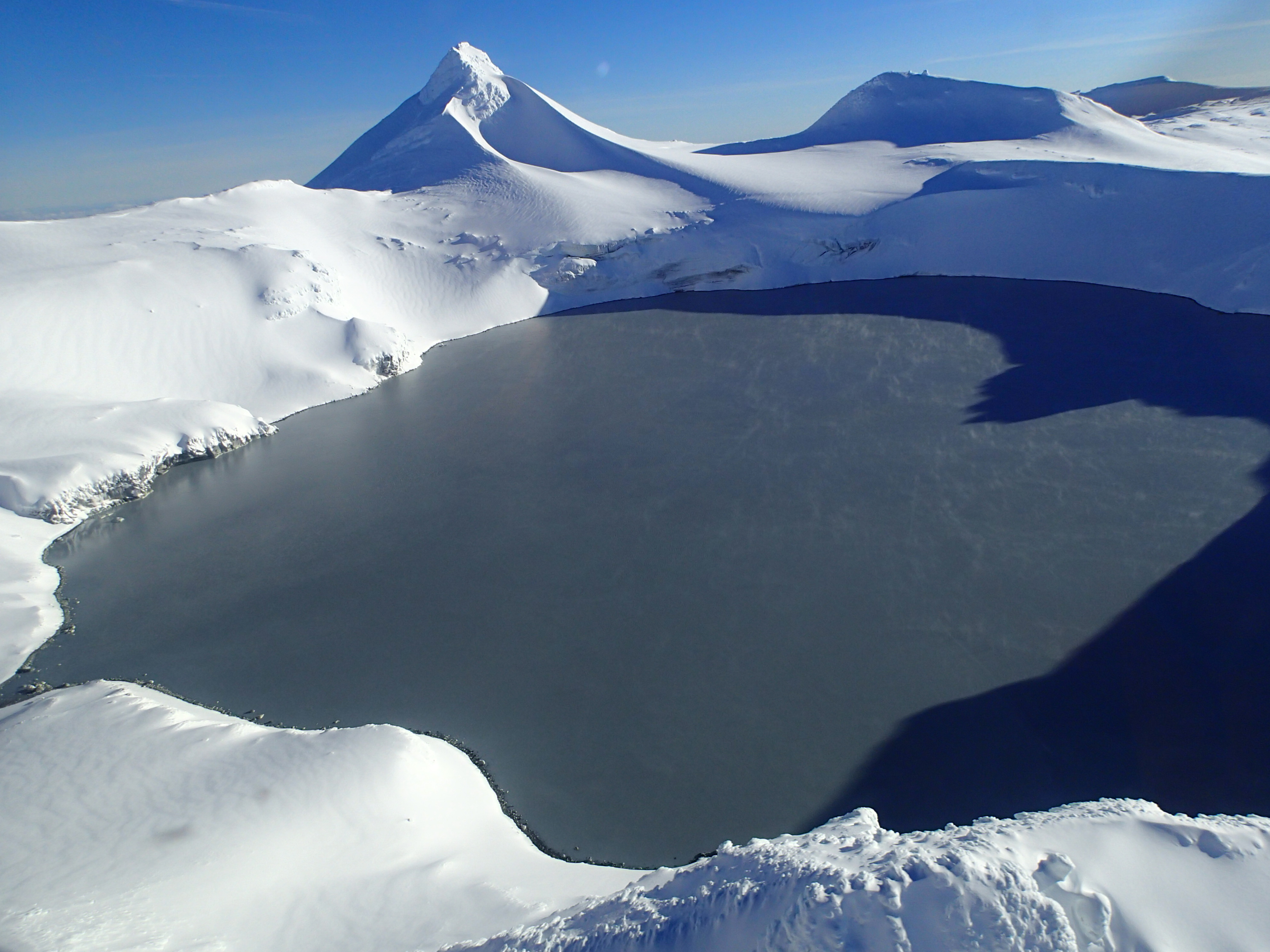
Ruapehu , New Zealand :
Volcanic Alert Bulletin ; Ruapehu Volcano
Volcanic Alert Level remains at 1
Aviation Colour Code remains at Green
Te Wai ā-moe (Crater Lake) temperature at Mt Ruapehu is rising along with an increase in volcanic tremor. This is consistent with minor volcanic unrest behaviour. The Volcanic Alert Level remains at 1.
Te Wai ā-moe has a clear temperature cycle that we have observed since 2003. During these cycles, the temperature ranges between ~12 and 40 °C over a period of ~12 months. In our last report (RUA 2018-02), we described how the relatively long-period of elevated temperature of Te Wai ā-moe was coming to an end. During that elevated temperature period, the lake reached ~ 38°C and we expected the lake to then cool as it has done many times before. Over the past 2 months, the lake has indeed cooled to ~ 20 °C where it remained at this low temperature until Tuesday last week, when the lake starting heating again at a rate of ~ 1 °C per day. Following previous heating cycles, we expect the lake to continue heating for the coming weeks.
Coincident with the increasing lake temperature, we have also noticed that the level of volcanic tremor has increased. This is a characteristic feature of a heating cycle and represents the increased flow of hydrothermal fluids into the lake. Previous heating cycles have shown this increased tremor to last for days to weeks.
As part of our normal routine monitoring, we aim to visit Te Wai ā-moe this week (weather permitting) to collect water and gas samples from the lake.
The Crater Lake has undergone many heating and cooling cycles in the past and we don’t see any unusual signs of increased unrest. Therefore, current observations are consistent with minor unrest behaviour and because of this, we remain at Volcanic Alert Level 1 and the Aviation Colour Code stays at Green.
Volcano Alert Level 1 corresponds to minor unrest. While this is the case, it is a useful reminder that eruptions can occur with little or no warning.
GNS Science continues to closely monitor Mt Ruapehu and our other active volcanoes.
Source : Geonet , Geoff Kilgour Duty Volcanologue
Photo : Geonet