June 02 , 2018 .
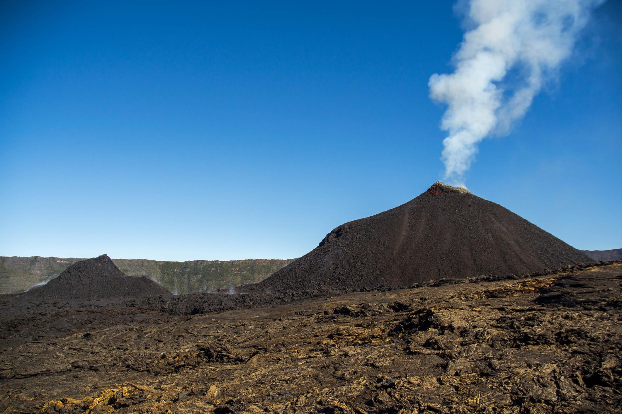
Pu’u ‘Ō’ō / Kilauea , Hawai :
Thursday, May 31, 2018, 10:43 PM HST (Friday, June 1, 2018, 08:43 UTC)
19°25’16 » N 155°17’13 » W,
Summit Elevation 4091 ft (1247 m)
Current Volcano Alert Level: WARNING
Current Aviation Color Code: RED
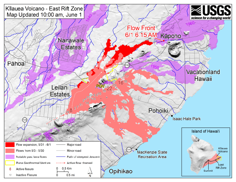
Kīlauea Volcano Lower East Rift Zone
Vigorous eruption of lava continues from the lower East Rift Zone (LERZ) fissure system in the area of Leilani Estates and Lanipuna Gardens.
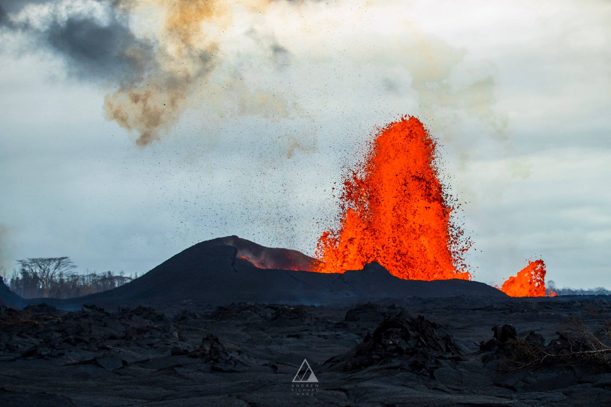
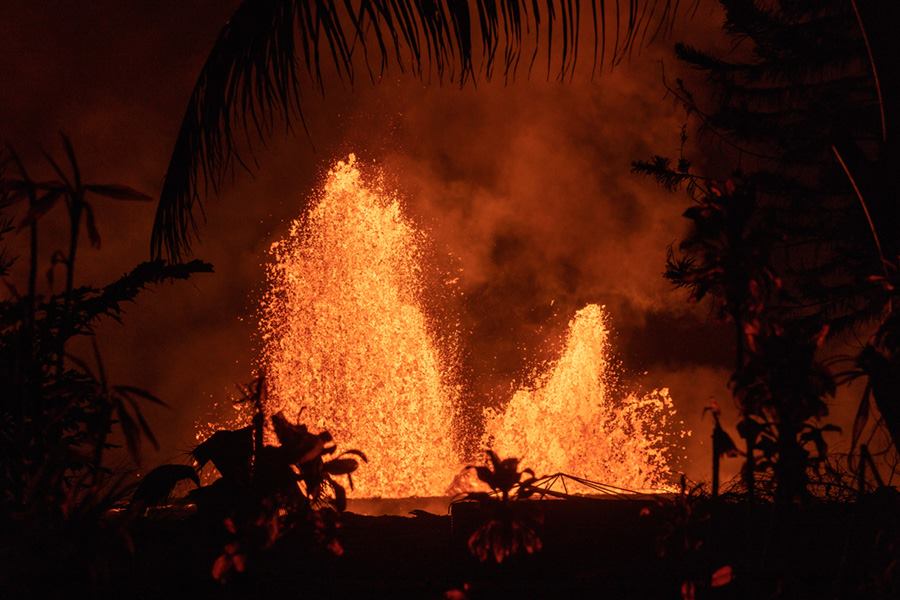
Fissure 8 is continuing to produce persistent fountains that are reaching heights of up to 260 feet. A small spatter cone is forming on the downwind side of the fountain and is approximately 100 feet high. The fountains are feeding a major flow field heading north through Leilani Estates and then to the northeast along the course of Highway 132. Minor overflows from the margins of the channel are occurring along its length. The front of the Fissure 8 flow is advancing through agricultural lands and had crossed Railroad Avenue by 7:30 PM HST. Ground and UAS crews are in the area closely monitoring the progress of the Fissure 8 flow front. At 21:53 PM HST, the flow front was approximately 1.1 miles from the Four Corners area (the intersection of Highways 132 and 137).
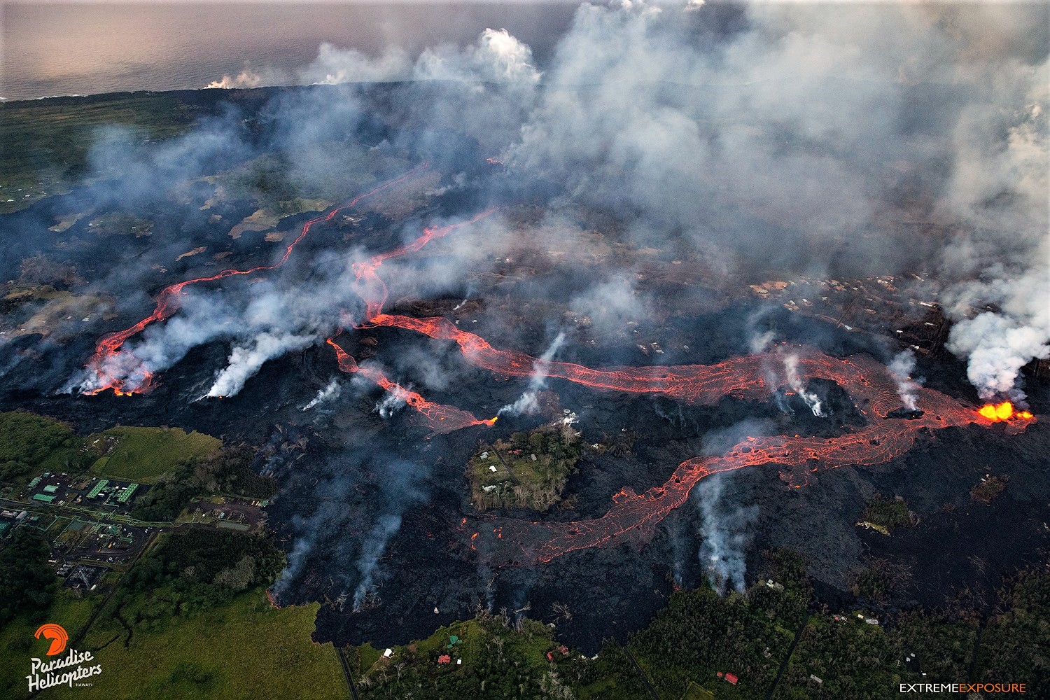
The Fissure 18 flow that advanced to within 0.5 mi of Highway 137 has stagnated. The new flow that branches from the same channel 1.5 miles upslope appears to have captured most of the lava output from Fissure 18. It is descending downslope just to the south of the previous flow.
Fissure 22 is weakly active, and lava is pooling around the vent.
Pele’s hair and other lightweight volcanic glass from high fountaining of Fissure 8 are falling downwind of the fissure and accumulating on the ground within Leilani Estates. Winds may waft lighter particles to greater distances. Residents are urged to minimize exposure to these volcanic particles, which can cause skin and eye irritation similar to volcanic ash.
https://www.facebook.com/noah.vanbarriger/videos/10209146008927534/
HVO field crews are on site tracking the fountains, lava flows, and spattering from multiple fissures as conditions allow and reporting information to Hawaii County Civil Defense.
Volcanic gas emissions remain very high from the fissure eruptions. Trade wind conditions are bringing vog to the south and west sides of the Island of Hawaii.
Magma continues to be supplied to the lower East Rift Zone. Earthquake locations have not moved farther downrift in the past few days and the number of located earthquakes remains low. Seismicity at the summit remain low with numerous small magnitude earthquakes and low amplitude background tremor.
Additional ground cracking and outbreaks of lava in the area of the active fissures are possible. Residents downslope of the region of fissures should heed all Hawaii County Civil Defense messages and warnings.
USGS/HVO continues to monitor the lower East Rift Zone activity 24/7 in coordination with Hawaii County.
Kīlauea Volcano Summit
Ash continued to erupt intermittently from the vent within Halemaʻumaʻu crater at Kīlauea’s summit. Additional explosive events that could produce minor amounts of ash fall downwind are possible at any time. Earthquake activity is elevated at the summit, with many small events. Volcanic gas emissions at the summit remain high.
Friday, June 1, 2018, 9:21 AM HST (Friday, June 1, 2018, 19:21 UTC)
Kīlauea Volcano Lower East Rift Zone
Vigorous eruption of lava continues from the lower East Rift Zone (LERZ) fissure system in the area of Leilani Estates and Lanipuna Gardens.
Overnight, fountaining at Fissure 8 continued to feed a channelized lava flow to the northeast along Highway 132. Small overflows from the channel are occurring along its length, including in a few places near the intersection of Highway 132 and Pohoiki road. The advance rates of the distal part of the flow overnight were low as lava ponded in a flat area. In the last few hours, advance rates have picked up to about 100 yards/hour. As of 6:30 AM HST, the lava flow front was 0.84 miles above Four Corners (the intersection of Highway 132 and 137). Minor advancement occurred on other branches of the Fissure 8 lava flow.
Fissure 18 and its associated flow are weakly active with widely scattered lava breakouts. Fissure 22 is inactive.
Kilauea – 2018-06-01 19:18:51 .
Overflight at 6:30 AM HST showed Fissure 8 lava flow to be 0.84 miles above Four Corners. Over the last 2 hours it has advanced at a rate of 100 yards per hour. White steam plume at summit; earthquake activity remains high.
June 01 , 2018 9:00am County of Hawaii Civil Defense, evacuate Kapoho area:
A message from COUNTY OF HAWAII
This is a Civil Defense Message for Friday, June 1 at 9:00 in the morning.
Hawaiian Volcano Observatory reports that vigorous lava eruptions continue on the east rift of Kilauea. Fissure 8 is very active and producing a large, fast-moving flow. The flow front is half-a-mile above the Four Corners area, and moving quickly. At the present rate, it is possible the lava flow may cross Government Beach Road near Four Corners within 7 to 10 hours.
Due to the rapid lava flow, the following policies are in effect for the Four Corners area:
Residents in Vacationland, Kapoho Beach Lots and in areas near Highway 137 are advised to evacuate now.
Traffic is flowing both ways to allow evacuation.
Residents should complete evacuation by 2:00 this afternoon, or risk the possibility of being isolated.
Source : HVO.
Photos : Bruce Omori , Andrew Hara , Martin Rietze.
Carte : USGS
Vidéo : Noah Van Barriger
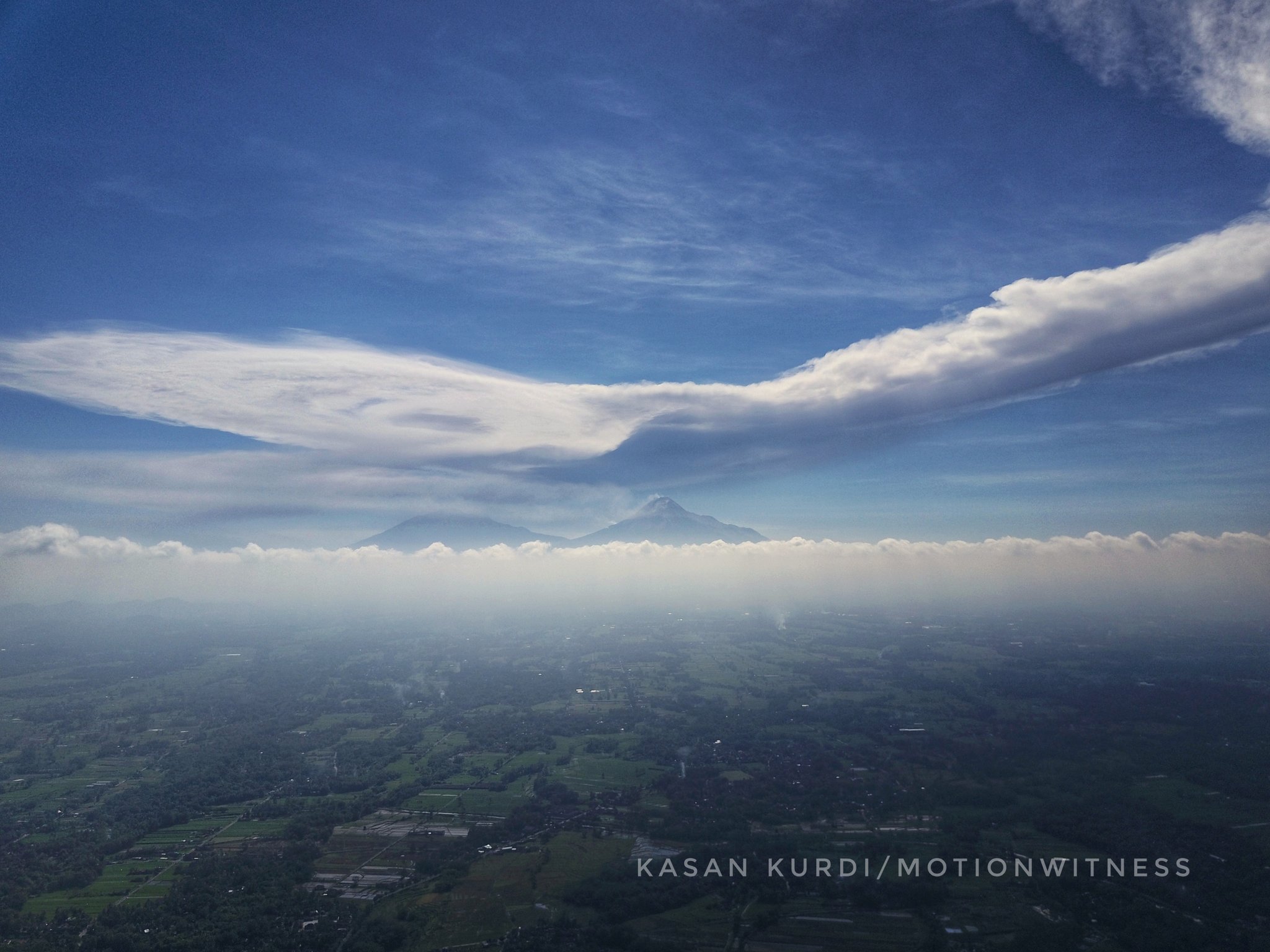
Mérapi , Indonesia :
VOLCANO OBSERVATORY NOTICE FOR AVIATION – VONA.
Issued: June 01 , 2018.
Volcano: Merapi (263250)
Current Aviation Colour Code: ORANGE
Previous Aviation Colour Code: orange
Source: Merapi Volcano Observatory
Notice Number: 2018MER12
Volcano Location: S 07 deg 32 min 31 sec E 110 deg 26 min 31 sec
Area: Special Region of Yogyakarta, Indonesia
Summit Elevation: 9498 FT (2968 M)
Volcanic Activity Summary:
Eruption with volcanic ash cloud at 14:00 UTC (21.00 local). Eruption has deceased
Volcanic Cloud Height:
Best estimate of ash-cloud top is around 12698 FT (3968 M) above sea level, may be higher than what can be observed clearly. Source of height data: ground observer.
Other Volcanic Cloud Information:
Ash-cloud moving to north west.
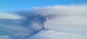
INFORMATION on the eruption of G.MERAPI.
The Merapi erupted on June 1, 2018 at 20:20, with a height of the ash column that was observed ± 6,000 m above the peaks (± 8968 m above sea level). Columns of gray color were observed with a strong intensity, inclined towards the West. This eruption is recorded in the seismogram with a maximum amplitude of 77 mm and a duration of ± 2 minutes.
Since the height of the eruption column exceeds 6000 m above sea level, the VONA code has been assigned the color code RED. The VONA color code may change depending on the current conditions.
https://www.facebook.com/ratu.s.m.7/videos/403253410153591/
Currently, G. Merapi is at alert level II (Waspada) with recommendations:
Climbing activities are temporarily not recommended, except for the benefit of investigation and research related to disaster mitigation efforts.
A radius of 3 km around the peak of G.Merapi must be prohibited activities.
People living around the volcano must be made aware of the activities of G.Merapi.
If there is a significant change in the activity of G.Merapi, the status of Mount Merapi activity will be examined.
Source : Magma Indonesie . PVMBG Centre de Recherche et de Développement de la Technologie des Catastrophes Géologiques
Photo : Kasan Kurdi.
Vidéo : Ratu Setya Mangkunegara
Piton de la Fournaise , La Réunion :
Monthly bulletin of Friday, June 1, 2018:
Seismicity:
In May 2018, the OVPF recorded a total of:
• 7 superficial volcano-tectonic earthquakes (0 to 2 km deep) beneath the summit craters;
• a deep earthquake (> 2 km deep);
• 190 collapses (in the crater Dolomieu and at the ramparts of Enclos Fouqué);
• 22 local earthquakes (under the island, Piton des Neiges side);
• 44 regional earthquakes (in the Indian Ocean area).
The month of May 2018 will have been marked by an eruptive activity (still in progress at the date of writing of this bulletin), started on April 27 (southern flank of the terminal cone) and presenting a low seismic activity (7 volcano-tectonic earthquakes ).
The 44 recorded regional earthquakes are linked to the seismic crisis of Mayotte started on May 10, 2018 (about 50 km offshore, east of the island), whose strongest earthquakes were recorded in Reunion by the seismological network of the OVPF.
Deformation:
Following a phase of deflation (deflation) of the building associated with the injection of magma from the reservoir to the eruptive site (eruption started on April 27, 2018), inflation (swelling) of the building has resumed since May 15, meaning that the deep magmatic system continues to pressurize.
Geochemistry of gases:
– CO2 concentrations in soil: On distal stations in the Plains region, CO2 concentrations in soil reached the highest values at the onset of eruption (April 27th), and then gradually decreased to May 18 before rising weakly between May 18 and May 26. Since May 26th, the values are gradually decreasing (Figure 1). The same trends are observed on the measurement points at the level of the volcano.
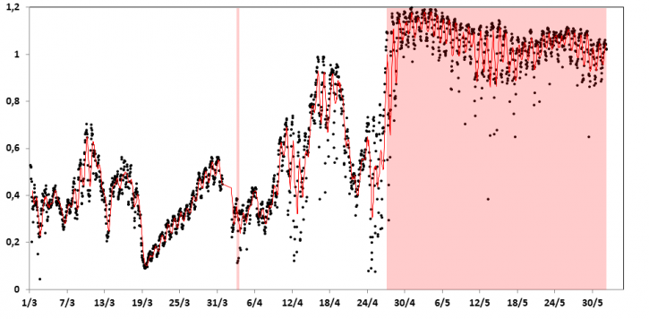
Figure 1: CO2 concentrations in soil measured on the PCRN station, located in Plaine des Cafres. The eruptions are indicated in red. (© OVPF / IPGP)
The increase in CO2 concentrations in the soil observed between May 18 and May 26 corresponds to the tremor re-increase phase and the building’s inflation recovery around May 15.
– Emissions of gas at the fumaroles of the summit:
Following the increase observed between April 23 and 27, CO2 concentrations in the atmosphere decreased gradually between early May and May 18. Since then, a small increase has been observed.
The flow of SO2 declined exponentially throughout the month of May (from a high of 2 kt / day on April 28 to less than 0.3 kt / day since May 7). This evolution is consistent with the gradual decrease of the flow of lava on the surface.
– SO2 emissions in the air in the Enclos Fouqué: variations of SO2 emissions in the air were observed during the month of May in relation with the eruptive activity. Thus, the decrease in height of the gas plume at the eruptive site after May 7 resulted in an increased concentration of SO2 in the ground atmosphere within the Enclos Fouqué. At the top, a gradual increase in SO2 concentrations was recorded until May 10th (maximum of 10.5 ppmv) to decrease thereafter.
May 2018 review:
The month of May 2018 will be marked by the continuation of the eruption started on April 27, 2018. Geophysical (deformation, eruptive tremor), geochemical data and preliminary observations on eruptive products suggest that the eruption began with the eruption. emission of degassed lavas and pyroclasts, followed by a phase of rising magma less degassed since about May 15.
This new magmatic contribution may have contributed to maintaining the eruptive activity over a period of several weeks, despite the very low eruptive flow rates measured on the surface since May 7th.
Exceptional Bulletin from Friday, June 1, 2018 at 3:00 pm (local time)
The eruption started on April 27, 2018 at 23:50 local time stopped today at 14:30, after more than 18:30 of gas piston phase.
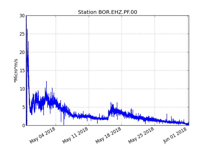
Figure 1: Evolution of RSAM (indicator of volcanic tremor and intensity of eruption) between 20:00 (16:00 UTC) on April 27 and 14:30 (10:30 UTC) on June 1 at the BOR seismic station (located at the top) . (© OVPF / IPGP)
Source : OVPF
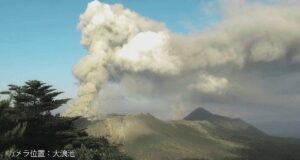
Fuego , Guatemala :
Type of activity: Vulcanian
Morphology: Composite Stratovolcan
Location: 14 ° 28’54˝ Latitude N; 90 ° 52’54˝ Longitude W.
Height: 3,763msnm.
Weather Conditions: Partly Cloudy
Wind: North at 3 km / h
Precipitation: 4.6 mm
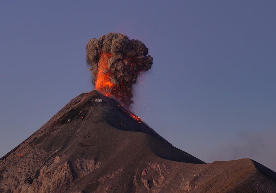
Activity:
Presence of weak, white, degassing fumaroles rising to 4500 m and spreading southward. Early in the morning 5 to 8 low to moderate explosions per hour were observed which expelled gray ash columns at 4600-4800 meters above sea level, these are scattered 8 to 14 kilometers to the south. . Low, moderate and strong rumblings are reported with a shock wave at 15 – 20 km causing vibrations in the roofs of houses on the southern flank. Incandescent pulses at 100/200 m above the crater generate moderate avalanches with fallout of materials in Seca, Ceniza and Lajas canyons with trajectories to the edge of the vegetation, low and moderate sounds such as a jet engine with periods of 5 to 8 minutes, as well as falls of fine ash particles in Panimache I.
Source : Insivumeh
Photo : Martin Rietze.