June 01 , 2018.
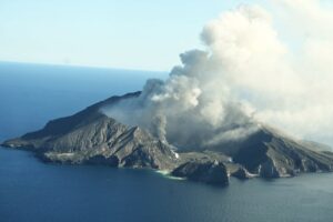
Pu’u ‘Ō’ō / Kilauea , Hawai :
Wednesday, May 30, 2018, 10:11 PM HST (Thursday, May 31, 2018, 08:11 UTC)
19°25’16 » N 155°17’13 » W,
Summit Elevation 4091 ft (1247 m)
Current Volcano Alert Level: WARNING
Current Aviation Color Code: RED
Kīlauea Volcano Lower East Rift Zone
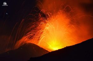
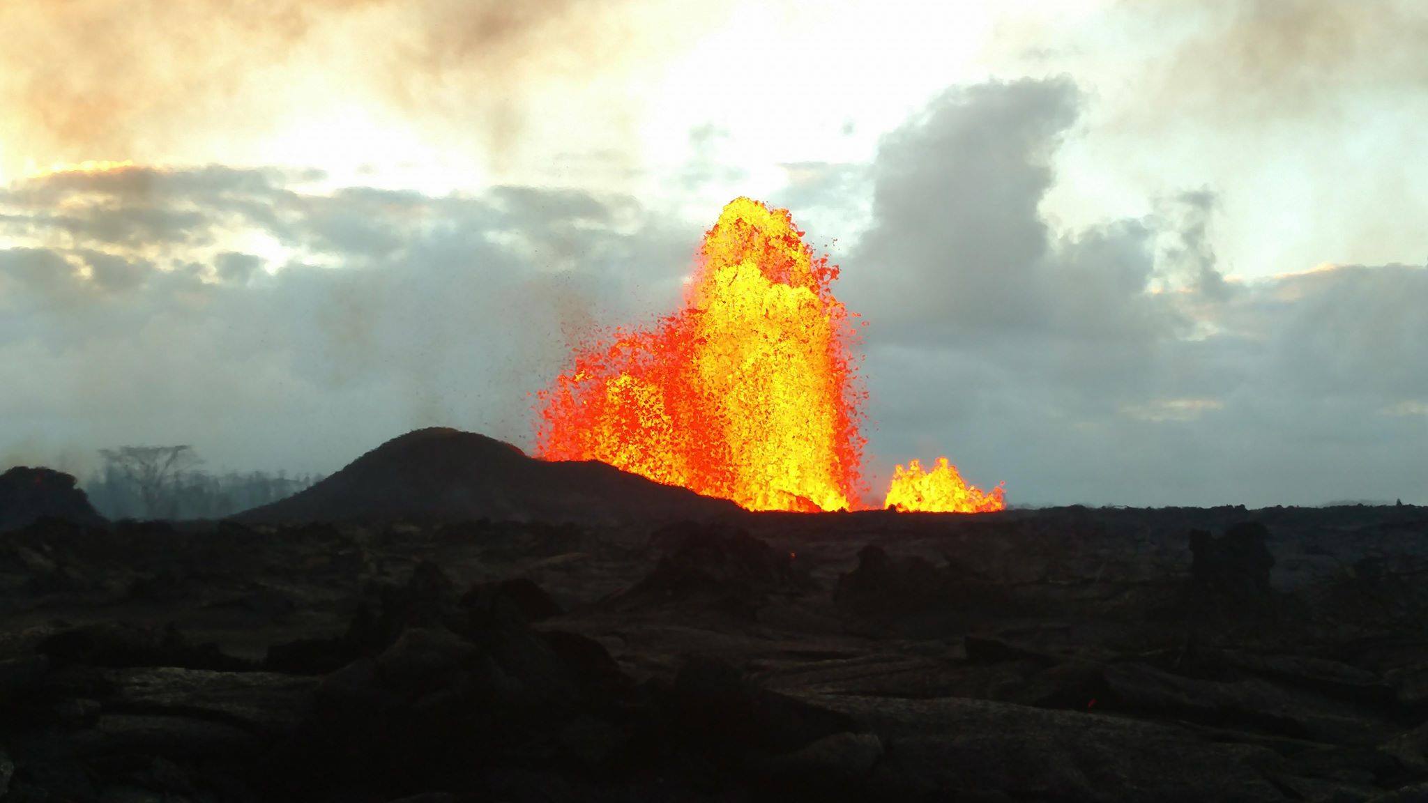
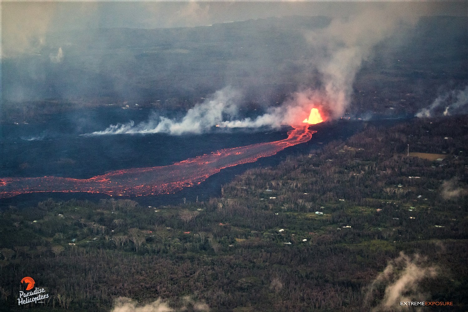
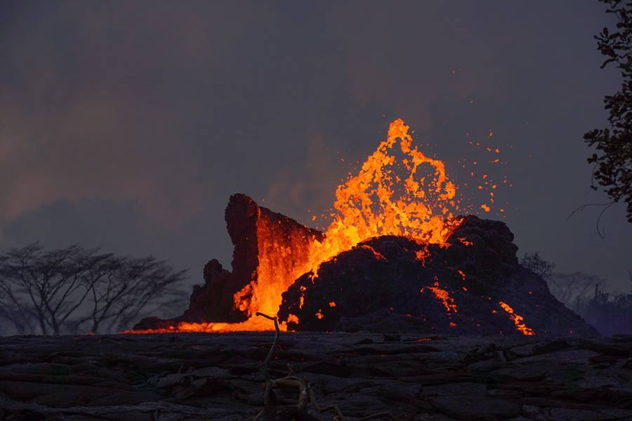
Fissure 8 continues to maintain eruptive fountains reaching 200-250 feet. Subsidiary fountains in the vicinity of Fissure 8 are also active although with much less vigor, seldom exceeding 60 feet in height. This fountaining continues to feed a lava flow that is moving north out of Leilani Estates and then northeast along Highway 132 into the area of Noni Farms road. Flow front advance has slowed to less than 50 yards per hour.
https://www.facebook.com/hawaiicountycivildefense/videos/905334679665825/
By late afternoon, the front of the Fissure 18 flow was about 0.5 miles from Highway 137 and was spreading and slowing. In the late afternoon, a new flow lobe began branching from the south side of the fissure 18 flow approximately 1.5 miles upslope from the flow front. During the day, sporadic bursts of activity were also observed from Fissures 22, 6, and 13. Low level spattering and intermittent fountaining from Fissure 21 were also observed in the late afternoon and early evening.
Pele’s hair and and other lightweight volcanic glass from high fountaining of Fissure 8 are falling to the west of the fissure and accumulating on the ground within Leilani Estates. Winds may waft lighter particles to greater distances. Residents are urged to minimize exposure to these volcanic particles, which can cause skin and eye irritation similar to volcanic ash.
HVO field crews are on site tracking the fountains, lava flows, and spattering from multiple fissures as conditions allow and reporting information to Hawaii County Civil Defense. Crews are also checking on the status of ground cracks on Highway 130.
Volcanic gas emissions remain very high from the fissure eruptions. Trade wind conditions are bringing vog to the south and west sides of the Island of Hawaii.
Magma continues to be supplied to the lower East Rift Zone. Earthquake locations have not moved farther downrift in the past few days and the number of located earthquakes remains low.
Additional ground cracking and outbreaks of lava in the area of the active fissures are possible. Residents downslope of the region of fissures should heed all Hawaii County Civil Defense messages and warnings.
USGS/HVO continues to monitor the lower East Rift Zone activity 24/7 in coordination with Hawaii County Civil Defense.
Kīlauea Volcano Summit
Ash continued to erupt intermittently from the vent within Halemaʻumaʻu crater at Kīlauea’s summit. Additional explosive events that could produce minor amounts of ash fall downwind are possible at any time. Earthquake activity is elevated at the summit, with a few felt events reported throughout the day. Volcanic gas emissions at the summit remain high.
Thursday, May 31, 2018, 11:27 AM HST (Thursday, May 31, 2018, 21:27 UTC)
Kīlauea Volcano Lower East Rift Zone
Overnight, Fissure 8 continued to produce persistent fountains that reached heights of 200-250 feet. A small spatter cone is forming on the downwind side of the fountain and is approximately 100 feet high. The fountains are feeding flow activity to the northeast, and minor overflows from the Fissure 8 channel are occurring along its length. One overflow covered the remaining northern part of Makamae Street in Leilani Estates. This overflow crossed Kahukai street, filling in a low area between Makamae and Luana streets. The front of the Fissure 8 flow near Noni Farms road advanced at rates of about 80 yards/hour. At 6:15 AM HST, the flow front was 2.2 miles above the Four Corners area.
High eruption rates from Fissure 8 have led to the formation of a leveed channel along the western edge of the lava flow. Failure of flow levees could result in rapid advance of flows. Flow margins are extremely hazardous and should not be approached.
Additional eruptive activity overnight occurred from Fissure 7/21. Fissure 18 is also active, but the lava flow, which was moving toward Highway 137 last night, has stalled.
Pele’s hair and other lightweight volcanic glass from high fountaining of Fissure 8 are falling downwind of the fissure and accumulating on the ground within Leilani Estates. Winds may waft lighter particles to greater distances. Residents are urged to minimize exposure to these volcanic particles, which can cause skin and eye irritation similar to volcanic ash.
Kīlauea Volcano Summit
Ash continued to erupt intermittently from the vent within Halemaʻumaʻu crater at Kīlauea’s summit. Additional explosive events that could produce minor amounts of ash fall downwind are possible at any time. Earthquake activity is elevated at the summit, with many small events occurring overnight. Volcanic gas emissions at the summit remain high.
Thursday, May 31, 2018, 6:41 PM HST (Friday, June 1, 2018, 04:41 UTC)
Kīlauea Volcano Lower East Rift Zone
Fissure 8 continued to produce persistent fountains that reached heights up to 260 feet. A small spatter cone is forming on the downwind side of the fountain and is approximately 100 feet high. The fountains are feeding flow activity to the northeast, and minor overflows from the Fissure 8 channel are occurring along its length. One overflow covered the remaining northern part of Makamae Street in Leilani Estates. This overflow crossed Kahukai street, filling in a low area between Makamae and Luana streets. The front of the Fissure 8 flow near Noni Farms road advanced at rates up to 100 yards/hour. At 12:30 PM HST, the flow front was 1.9 miles from the Four Corners area.
High eruption rates from Fissure 8 have led to the formation of a leveed channel along the western edge of the lava flow. Failure of flow levees could result in rapid advance of flows. Flow margins are extremely hazardous and should not be approached.
Fissure 18 feeds the upper part of a lava flow that extends to 1.5 mi from Highway 137; the lower portion of the fissure 18 lava flow stalled about 0.5 mi from the highway. Fissure 2 is weakly active and is pooling lava around the vent.
Additional ground cracking and outbreaks of lava in the area of the active fissures are possible. Residents downslope of the region of fissures should heed all Hawaii County Civil Defense messages and warnings.
Kilauea – 2018-06-01 02:10:42
As of last night, area covered by lava from Kīlauea LERZ eruption equal to 5.5 square miles (3534 acres). Highest temperature from F8 measured today, 2039 F (1115 C).
Source : HVO
Photo : Ryan Finlay / Hawaii Tracker, Bruce Omori , Martin Rietze.
Vidéos : Hawai County Civil Defense Agency , Big Island Vidéo News.
Reventador , Ecuador :
Summary:
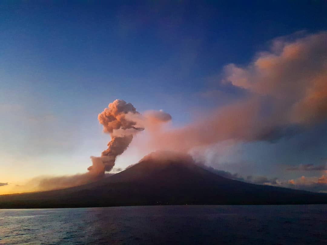
Sunday, May 27, 2018, volcanic ash falls were reported in the provinces of Imbabura (Antonio Ante, Otavalo), Napo (Quijos) and Pichincha (Cayambe, Pedro Moncayo, Quito). These ashes come from the El Reventador volcano. According to the seismic-acoustic record, the clouds and ash falls are linked to a broadcast at 4:42 am local time. This emission produced an ash cloud which reached 6.7 km high, (~ 3.1 km above the crater) which was dissipated by the west wind with a speed of 12 m / s (~ 42 km / h).

Thanks to the samples collected by Cayambe GAD officials and individuals, a preliminary analysis of the ash was possible. Ash is made up of various materials (slag, dense lava, volcanic glass, free crystals, oxidized particles, ash aggregates) with an extremely fine size (<diameter of 0.063 to 0.25 mm). In all collection areas, the fall is considered very low. Based on the current activity of the volcano, it is possible that other ash falls occur, especially during the summer due to the direction of the winds (predominantly to the west) and their speed (> 10 m / s).
In case of ash fall, it is recommended to take the appropriate precautionary measures.
Seismic-acoustic recording:
Seismic-acoustic recording shows an event with a signal at 04:42 local time (Figure 1). This event, interpreted as a show, takes less than 3 minutes and has small amplitudes (Fig 2) but it is the only event with an acoustic signal. In addition, taking this time as the beginning and taking into account the dispersion of ash in the VAAC alert, we obtain the same wind speed (12 m / s) as the VAAC of Washington.
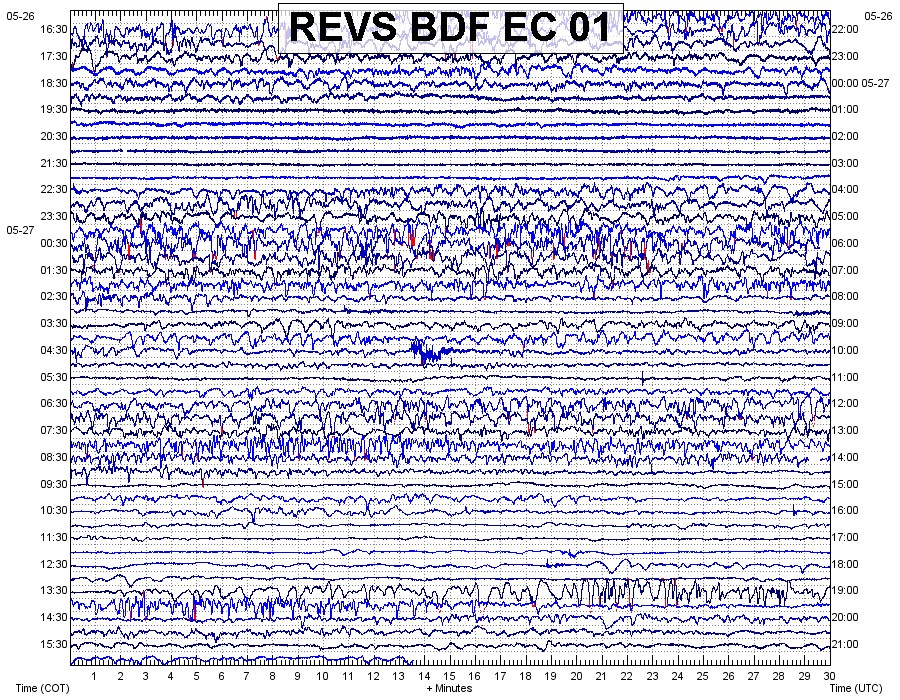
Figure 1. Acoustic recording (1 day) of the REVS station where an event with a pressure signal is observed at 04:42 local time on El Reventador (figure: M. Ruiz).
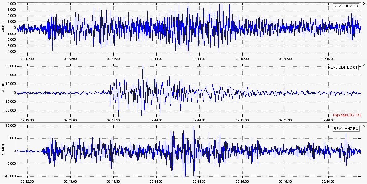
Figure 2. The seismic and acoustic recordings of REVS (REVS HHZ and REVS BDF) and seismic stations for REVN (REVN HHZ) of the event that occurred at 04:42 local time on El Reventador (Figure: M. Ruiz).
Interpretation:
The activity that caused the ashes to fall in the provinces of Napo, Imbabura and Quito on the morning of May 27 is associated with the El Reventador volcano. However, this is not an activity higher than that recorded in previous weeks and months. It is important to indicate that the ashfall was very small and was washed immediately with rain. Dispersion of ash to populated areas is the result of a combination of eruptive activity (ash column 3.1 km above crater level) and atmospheric conditions (strong westward wind) . At present the volcano does not present any significant changes in its internal and superficial activity. Therefore, like May 27, other such events may occur in the coming weeks or months.
Source : IGEPN
Photo : G Puli
Langila , New Britain (Papua New Guinea) :
5,525 ° S, 148,42 ° E
élévation : 1330 m
Based on satellite image analysis and model data, the Darwin VAAC reported that during May 23-28, Langila ash plumes reached altitudes of 2.4 to 3 km ( 8,000 to 10,000 sq. Ft. A year. and derived WSW, W and NW.
Source: Centre consultatif sur les cendres volcaniques de Darwin (VAAC), GVP.
Photo : David Gorman / Sherine France.
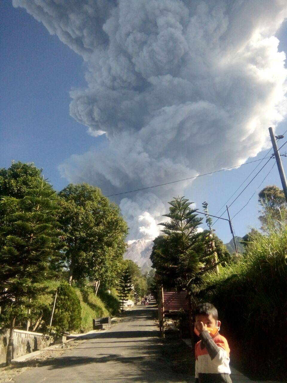
Mérapi , Indonesia :
VOLCANO OBSERVATORY NOTICE FOR AVIATION – VONA.
Issued: June 01 , 2018 .
Volcano: Merapi (263250)
Current Aviation Colour Code: RED
Previous Aviation Colour Code: green
Source: Merapi Volcano Observatory
Notice Number: 2018MER10
Volcano Location: S 07 deg 32 min 31 sec E 110 deg 26 min 31 sec
Area: Special Region of Yogyakarta, Indonesia
Summit Elevation: 9498 FT (2968 M)
Volcanic Activity Summary:
Eruption with volcanic ash cloud at 01:20 UTC (08.20 local). Eruption has deceased
Volcanic Cloud Height:
Best estimate of ash-cloud top is around 28698 FT (8968 M) above sea level, may be higher than what can be observed clearly. Source of height data: ground observer.
Other Volcanic Cloud Information:
Ash-cloud moving to north west.
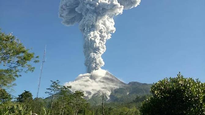
After the eruption of May 24, 2018 at 22:48, the eruption of this morning (01/06/18) at 08.20 had a maximum amplitude of 77 mm and a duration of 2 minutes. The eruption column was elevated 6000 m, oriented to the northwest and observed from the observation post of Mount Merapi in Jrakah.
Reported at 8:58 pm around the Pos PGM of Jrakah arrived a rain of ashes, at 09.02. At the beginning of the eruption, the wind was oriented to the northwest, but at 08.30, BMKG information Satklim Jogja indicates that the wind is oriented to the southwest.
Reported from the observation posts of the GMP of Jrakah and Babadan, white smoke appeared in the forest area in the northwest sector about 1.5 km from the peak, which probably indicates the presence of burning vegetation.
The seismic recordings of the last day (31/5/18) indicate 4 emission earthquakes, 5 VT-type earthquakes with a dominant depth of 3 km below the summit, 11 avalanche events and 1 tectonic earthquake. The appearance of VT type earthquakes has become an indication of the magmatic process affecting the eruption this morning. The extrusion of magma on the surface is still time consuming as the estimated magma position is currently still less than 3 km, depending on the depth of the VT earthquake that has occurred.
The deformation data did not show any significant symptoms of inflation or deflation.
Geochemical data from SO2 monitoring on Merapi showed no increase in flux.
Conclusion:
• This morning’s eruption and monitoring data indicate that the increase in Mount Merapi volcanic activity is still high, so the level of activity is still set at the WASPADA level (level II).
• A radius 3 km around the top of G. Merapi is not allowed for the activities of the population.
• Local governments and communities face the dangers of volcanic ash caused by this eruption.
Source : KESDM, Agence géologique, Centre de recherche PVMBG et Développement de la technologie des catastrophes géologiques , Magma Indonésie.
Photo: Indonesia National Disaster Mitigation Agency