May 29 , 2018.
Pu’u ‘Ō’ō / Kilauea , Hawai :
052718 7:46pm County of Hawaii Civil Defense, evacuating of parts of Leilani due to lava & Fire:
A message from COUNTY OF HAWAII
This is a Civil Defense Message for Sunday, May 27 at 7:45 in the evening.
Leilani Estates residents on Nohea St and Luana St between Leilani Ave and Kahukai, and Kupono Street between Malama Street and Leilani Avenue need to evacuate immediately due to a fast moving lava flow from Fissure 7.
Sunday, May 27, 2018, 11:35 PM HST (Monday, May 28, 2018, 09:35 UTC)
19°25’16 » N 155°17’13 » W,
Summit Elevation 4091 ft (1247 m)
Current Volcano Alert Level: WARNING
Current Aviation Color Code: RED
Kīlauea Volcano Lower East Rift Zone
Vigorous eruption of lava continues from the lower East Rift Zone (LERZ) fissure system in the area of Leilani Estates and Lanipuna Gardens.
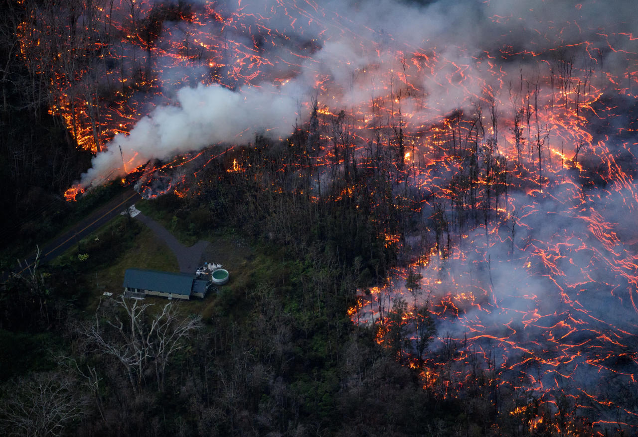
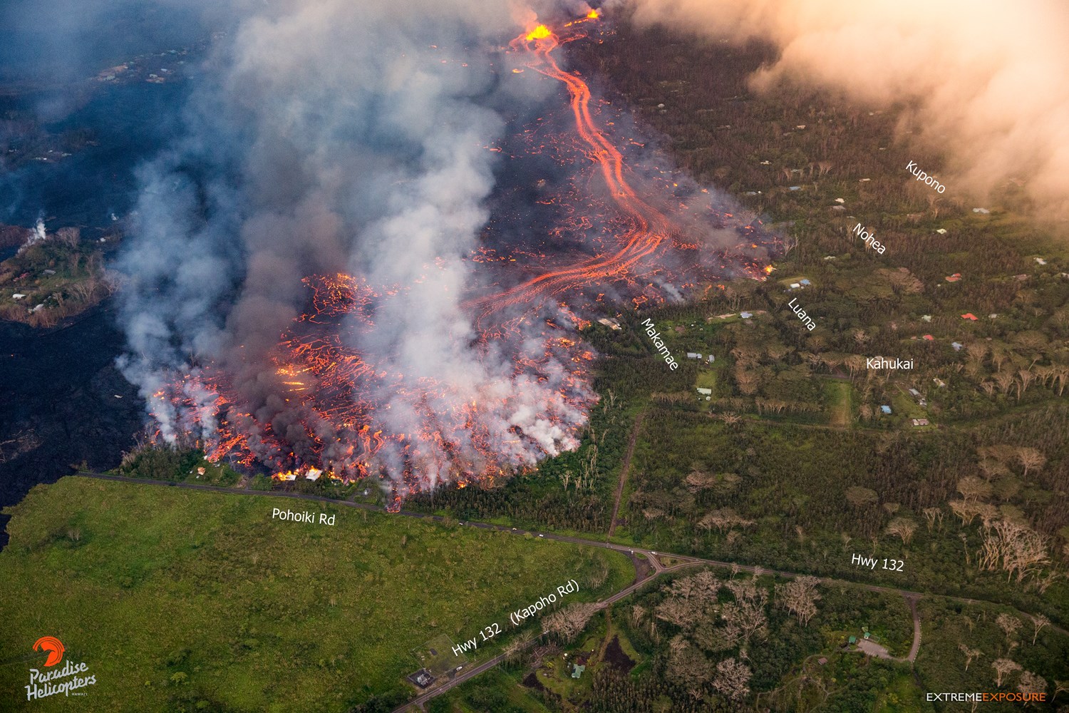
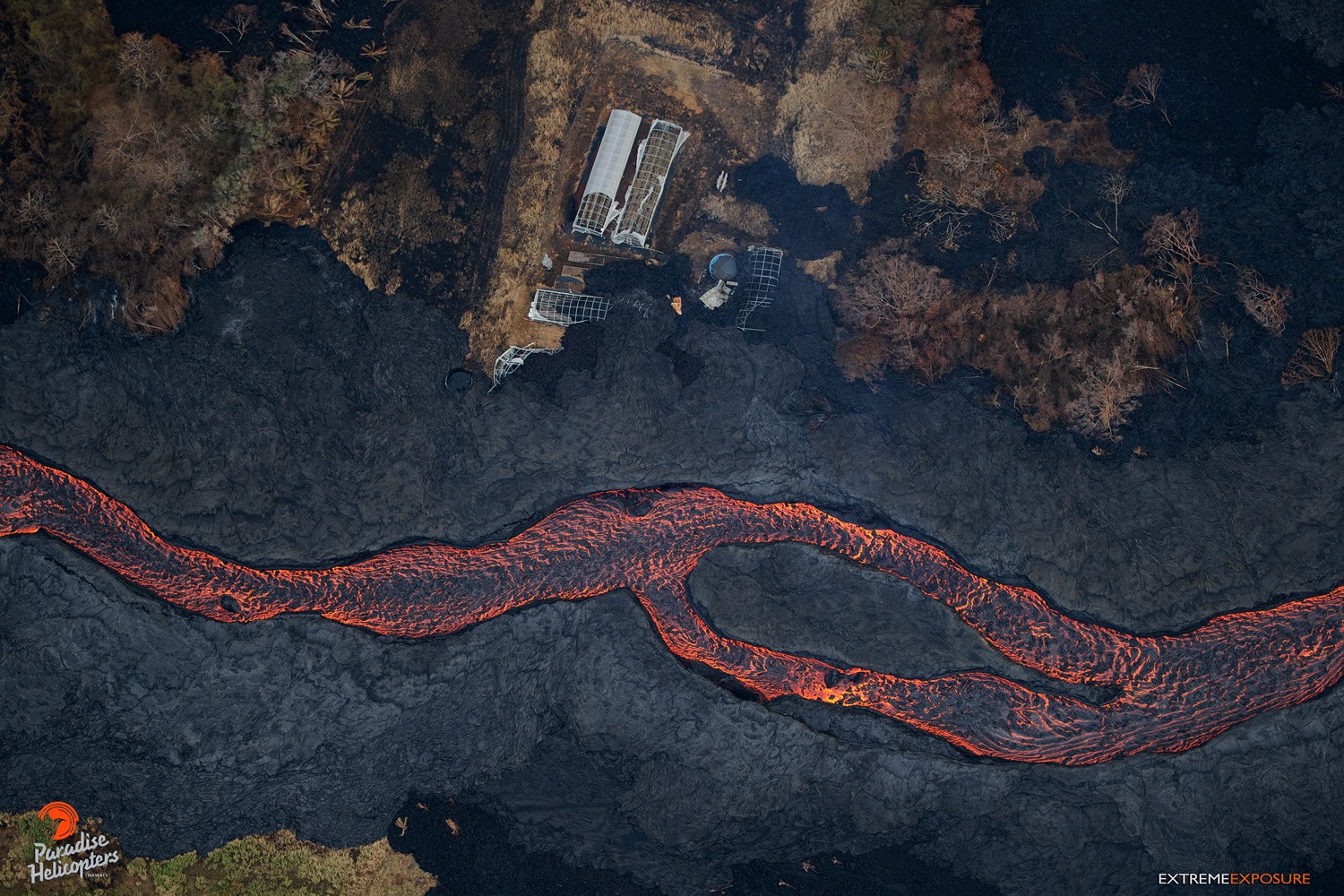
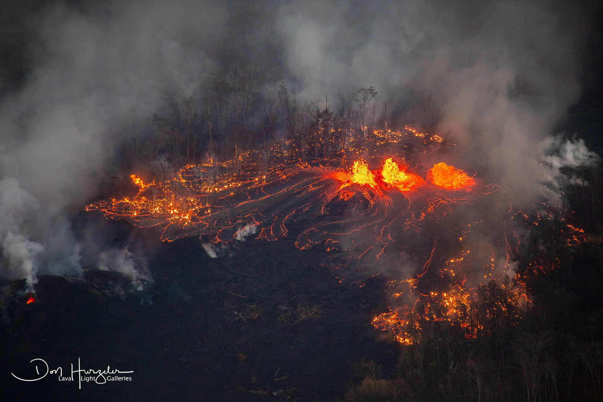
Fissures 7 and 8 remain the most active eruptive centers of the system and have been feeding lava flows that have advanced northeast onto PGV property. At about 7:00 PM HST, a fast-moving lava flow broke from this area and advanced rapidly to the north and west through the eastern portion of Leilani Estates. Several residents were evacuated in advance of the dangerous and fast-moving flows.
Activity at Fissure 22 has waned, and Fissure 13 is the dominant source of lava entering the ocean, which is occurring at three minor entry points. Fountaining is occurring at Fissure 8.
HVO field crews are on site tracking the fountains, lava flows, and spattering from multiple fissures as conditions allow and reporting information to Hawaii County Civil Defense. Crews are also checking on the status of ground cracks on Highway 130.
Volcanic gas emissions remain very high from the fissure eruptions. Trade winds are weakening, and widespread vog is expected on the Island of Hawaii on Monday.
Magma continues to be supplied to the lower East Rift Zone. Earthquake locations have not moved farther downrift in the past few days and the number of located earthquakes remains low.
Additional ground cracking and outbreaks of lava in the area of the active fissures are possible. Residents downslope of the region of fissures should heed all Hawaii County Civil Defense messages and warnings.
USGS/HVO continues to monitor the lower East Rift Zone activity 24/7 in coordination with Hawaii County Civil Defense.
https://www.facebook.com/lavanews/videos/210327659757539/
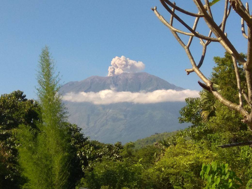
Kīlauea Volcano Summit
Ash continued to erupt intermittently from the vent within Halemaʻumaʻu crater, at Kīlauea’s summit, but no significant ash columns have been produced since noon on Sunday. Observations from the ground, by UAV, and by satellite during the past week have documented retreat of the summit vent walls due to collapse of the steep conduit and rim. Trade winds are causing ash fall to the southwest, but are diminishing in intensity as wind patterns shift late Sunday and early Monday. This may bring ashfall to communities around the summit area.
Earthquakes in the summit region continue as the summit area subsides and adjusts to the withdrawal of magma.
Additional explosive events that could produce minor amounts of ashfall downwind are possible at any time. Volcanic gas emissions at the summit remain high.
Monday, May 28, 2018, 10:32 AM HST (Monday, May 28, 2018, 20:32 UTC)
Kīlauea Volcano Lower East Rift Zone
Overnight, field crews confirmed that the fast-moving flow that broke out at about 7 PM HST Sunday night originated from Fissure 8. The fissure fed a channelized flow that moved north along the margin of the existing flow before turning east and crossing out of Leilani Estates near the intersection of Kahukai and Hookupu streets. As of 8 AM HST Monday morning it had started to cross Pohoiki Road, but the advance rate slowed from hundreds of meters (yards) per hour on Sunday night to a few meters (yards) per hour this morning.
Fissures 6/13 are inactive, and Fissure 9 is reactivated but erupting small amounts of lava that are pooling nearby. Fissure 7/21 are no longer active and lava flows from that fissure have largely stalled on PGV property.
Monday, May 28, 2018, 5:45 am – Kilauea’s lower east rift zone overflight: Fissures 8 and 24 are currently the only ones actively erupting as of early this morning, and it seems that the volume from other fissures is being released here, as this massive flow was on the move. Sadly, while we hovered above, about a dozen homes were being consumed
HVO field crews are on site tracking the fountains, lava flows, and spattering from multiple fissures as conditions allow and reporting information to Hawaii County Civil Defense. Crews are also checking on the status of ground cracks on Highway 130.
Volcanic gas emissions remain very high from the fissure eruptions. If a forecast shift in wind direction occurs today, widespread vog may be expected on the Island of Hawaii.
Magma continues to be supplied to the lower East Rift Zone. Earthquake locations have not moved farther downrift in the past few days and the number of located earthquakes remains low.
Kīlauea Volcano Summit
Ash continued to erupt intermittently from the vent within Halemaʻumaʻu crater, at Kīlauea’s summit. A brief emission event at about 4:35 AM HST this morning sent ash to about 10,000 feet above sea level but was not associated with a significant tilt offset. A similar event at about 6:30 AM sent ash to approximately 12,000 feet above sea level. Earthquakes are currently occurring at high rates in the summit area. Observations from the ground, by UAS, and by satellite during the past week have documented retreat of the summit vent walls due to collapse of the steep conduit and rim. Volcanic gas emissions at the summit remain high.
Monday, May 28, 2018, 4:35 PM HST (Tuesday, May 29, 2018, 02:35 UTC)
Kīlauea Volcano Lower East Rift Zone
The lava flow from Fissure 8 reached Pohoiki Rd. this morning and stalled as the Fissure’s activity abruptly diminished. A few fissures reactivated briefly during the day. As of the 1 pm overflight, Fissure 8, 18, 20, 22, 6/13, and 7/21 reactivated with Fissure 7/21 having the highest fountains. The reactivated fissures have not yet erupted enough lava to reach the coast so the two ocean entry sites were relatively inactive. Only a minor ooze of residual lava was entering the ocean from the Eastern channel.
Kīlauea Volcano Summit
Ash continued to erupt intermittently from the vent within Halemaʻumaʻu crater, at Kīlauea’s summit. Winds have weakened and shifted in direction so that ash fall could occur in communities around the summit area.
Source : HVO
Photo : Bruce Omori. Don Hurzeler .
Vidéos : Big Island Vidéo News. Lava news .
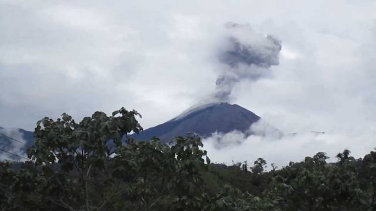
Reventador , Ecuador :
Volcan Reventador, Special Report No. 1 – 2018
Emission and ash fall in the provinces of Pichincha and Napo
On Sunday, May 27, 2018, volcanic ash falls were reported in the areas of Papallacta, San Antonio de Pichincha, Tabacundo, Cayambe, Puellaro, Puembo. The ash comes from the El Reventador volcano, erupted since November 2002, with activity characterized by continuous emissions and explosions since 2012. The internal and external activity of the volcano remains high, as the days and weeks before. The VAAC Volcanic Ash Warning Center in Washington reports a cloud of ash reaching an elevation of 6.7 km (3 km above crater level) today at 06:01 local time. Because of the height of this emission, with the high speed (12 m / s) and the direction of the wind (West), the ashes reached the mentioned sectors.
In the event of an ash fall, it is recommended that appropriate precautions be taken. If you detect ash in your area, please report it to the IGEPN.
IG-EPN maintains its vigilance and will report any significant changes in volcanic activity.
Seismicity: From 26 05 2018 11h00 to 27 05 2018 11h00
Long Period Type (LP): 20
Explosions (EXP): 5
Tremor of emission (TE): 11
Tremor Harmonic (TA): 5
Rain / lahars: Precipitation in the area. .
Emission / Ash Column: At night, steam, gas and ash emissions were observed up to 300 meters to the west. In the morning, VAAC Washington and a plane reported a column of ash 3 km above sea level. Due to the prevailing wind direction, fine particles have arrived in the inter-Andean valley.
Other monitoring parameters: No change.
Observations: Incandescence was observed at the summit, in addition to the descent of the blocks on all sides at 800 meters below the summit. This morning, a slight fall of ashes was reported in Papallacta, San Antonio de Pichincha, Tabacundo, Cayambe, Puellaro and Puembo.
Source : IGEPN
Photo : El comercio
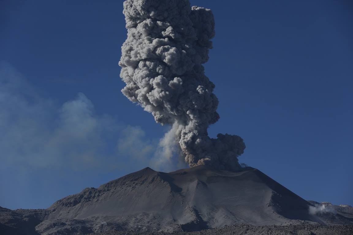
Sabancaya , Peru :
The explosive activity shows no significant changes, recording an average of 35 explosions / day. The significant occurrence of tremor activity associated with ash and gas emissions (approximately 4 hours) was recorded. The earthquakes associated with the rise of the magma (type Hybrids) remain low in number and energy.
The eruptive columns of gas and ash reached a maximum height of 3300 m above the crater. The dispersion of these materials occurred within a radius of about 30 km, mainly in the Northeast, East and Southeast directions. Ash falls have been reported in Huambo.
The volcanic gas (SO2) flow recorded on May 24 had a maximum value of 3950 tonnes / day, a value considered high.
The deformation does not show significant variations.
There were 9 thermal anomalies recorded according to the MIROVA system, with values between 3 MW and 21 MW VRP (Radiated Volcano Power).
In general, eruptive activity maintains moderate levels. No significant changes are expected in the following days.
Source : IGP
Photo : Photovolcanica
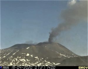
Agung , Indonesia :
VOLCANO OBSERVATORY NOTICE FOR AVIATION – VONA.
Issued: May 28 , 2018.
Volcano: Agung (264020)
Current Aviation Colour Code: ORANGE
Previous Aviation Colour Code: orange
Source: Agung Volcano Observatory
Notice Number: 2018AGU24
Volcano Location: S 08 deg 20 min 31 sec E 115 deg 30 min 29 sec
Area: Bali, Indonesia
Summit Elevation: 10054 FT (3142 M)
Volcanic Activity Summary:
Eruption with volcanic ash cloud at 21:39 UTC (05:39 Local)
Volcanic Cloud Height:
Best estimate of ash-cloud top is around 11654 FT (3642 M) above sea level, may be higher than what can be observed clearly. Source of height data: ground observer.
Other Volcanic Cloud Information:
Ash-cloud is moving southwest
Remarks:
Seismic activity is dominated by volcanic earthquake
Source : Magma Indonésie.
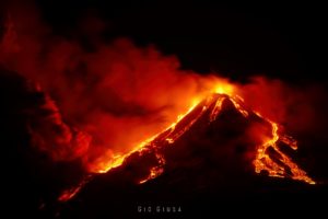
Piton de la Fournaise , La Réunion :
Activity Bulletin from Monday, May 28, 2018 to 17:00 (local time)
The eruption started on April 27, 2018 at 23:50 local time continues. The intensity of the volcanic tremor (indicator of the eruptive intensity at the surface) continues its progressive decrease.
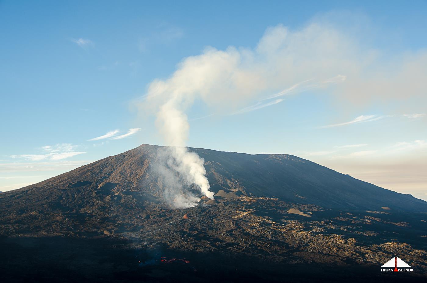
– Lava flows occur almost exclusively in tunnel. Degassing remains visible on the main vent.
– The inflation of the building continues.
– Surface flow rates have become too low to be estimated from satellite data.
– No volcano-tectonic earthquake has been recorded during the last 24 hours under the Piton de la Fournaise volcano .
Alert level: Alert 2-2 – Eruption in the Enclos .
Source : OVPF
Photo : Fournaise info