May 08 , 2018.
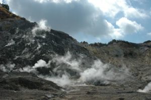
Pu’u ‘Ō’ō / Kilauea , Hawai :
19°25’16 » N 155°17’13 » W,
Summit Elevation 4091 ft (1247 m)
Current Volcano Alert Level: WARNING
Current Aviation Color Code: ORANGE
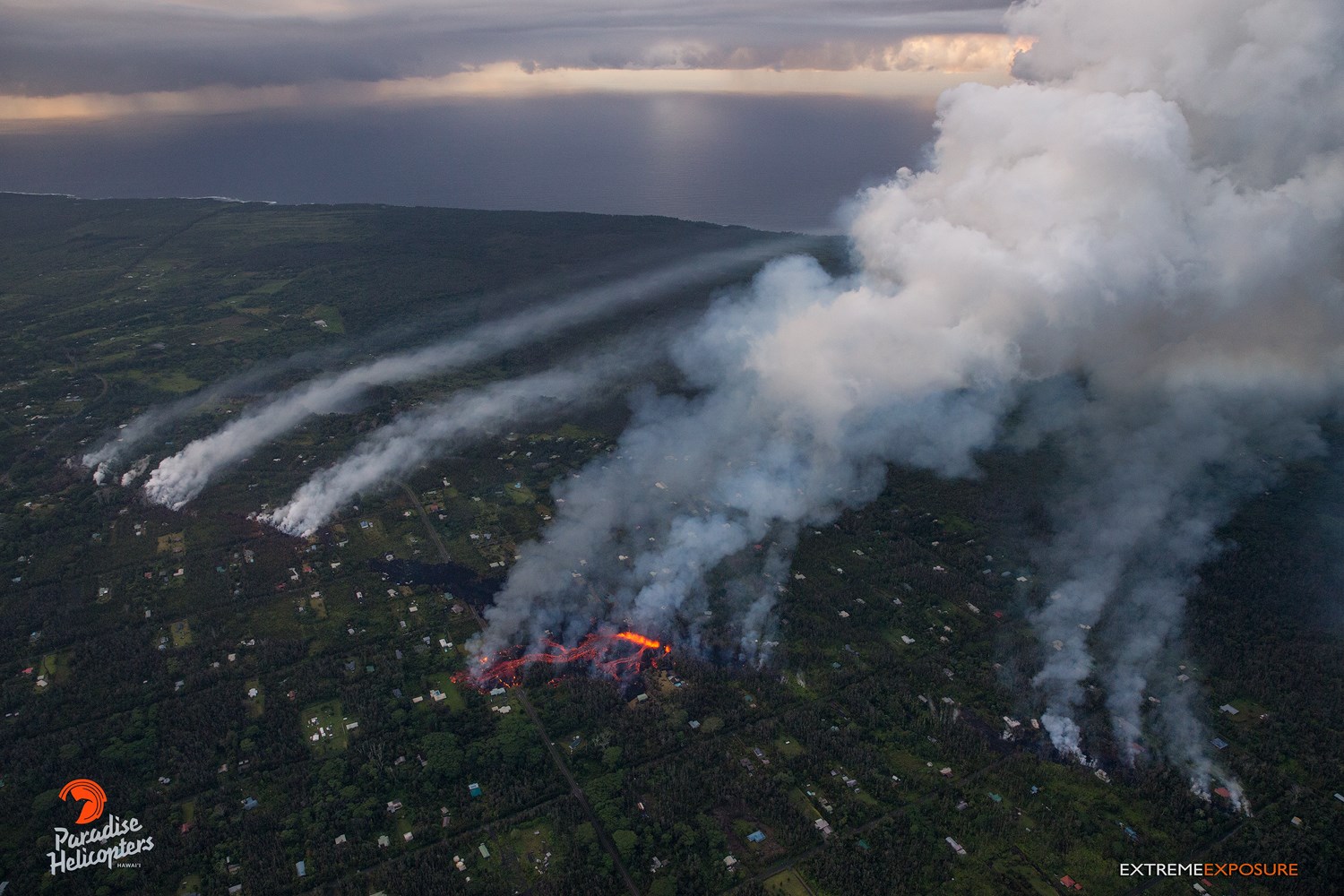
050718 6:00am Hawaii County Civil Defense information; 35 structures destroyed.
This is a Civil Defense Message for Monday, May 7 at 6 AM.
The East Rift Zone eruption in Leilani Subdivision continues. Hawaiian Volcano observatory confirms that active venting of lava and hazardous fumes continue in Leilani Estates Subdivision. Since the onset of this eruption, a total of 10 fissures have emerged, and 35 structures have been destroyed.
Due to the eruption, the following are issued:
The County of Hawaii thanks Leilani Estates residents for their cooperation and patience during yesterday’s property retrieval effort.
Conditions permitting, Leilani Estates residents will be allowed to check on their property from 7 AMto 6 PM each day until further notice. Follow the instructions of the authorities on scene. Be prepared to evacuate at a moment’s notice.
Hawaii Electric Light Company is working to try to keep power online. Treat all downed lines as live. Under no circumstances are you to approach or touch downed lines.
The Department of water Supply is working to establish a temporary bypass waterline to restore water service to the areas of Pohoiki, Vacationland, and Kapoho, we will keep you updated on this progress.
A water truck for public use is located near the Vacationland mailboxes.
No access is allowed at this time for residents of Lanipuna Gardens due to dangerous volcanic gases
Please, the residents of Leilani need our help. This is not the time for sightseeing. You can help tremendously by staying out of the area.
Department of Education announced Pahoa High, Intermediate and Elementary schools will be open today. Kua O Ka La, Hawaii Academy of Arts and Sciences, Nawahiokalaniopu’u and Ke Ana La’ahana are closed today.
The Hawaii County Police Department and the Prosecutor’s Office have established a policy of zero tolerance towards looting or vandalism. Under Emergency Provisions, any looting or vandalism will be treated as a felony.
The residents of Leilani Estates are going through a very difficult time. We ask for your understanding. We ask for your help
County, State and Federal partners continue to monitor the situation. You will be informed of any conditions that affect your safety.
Monday, May 7, 2018, 7:45 AM HST (Monday, May 7, 2018, 17:45 UTC)
19°25’16 » N 155°17’13 » W,
Summit Elevation 4091 ft (1247 m)
Current Volcano Alert Level: WARNING
Current Aviation Color Code: ORANGE
Summary:
Eruption of lava and gas continues at a low level along Kīlauea Volcano’s lower East Rift Zone within the Leilani Estates subdivision. Overnight, active emission of lava and spatter at multiple fissures was minimal. This is likely only a pause in activity; additional outbreaks or a resumption of activity are anticipated as seismicity continues in the area. Deflationary tilt at the summit of the volcano continues and the lava lake level continues to drop. There is no active lava in the Puʻu ʻŌʻō area. Aftershocks from Friday’s magnitude-6.9 earthquake continue and more should be expected, with larger aftershocks potentially producing rockfalls and associated ash clouds above Puʻu ʻŌʻō and Halemaʻumaʻu crater. Seismicity at Kīlauea’s summit remains elevated.
USGS/HVO continues to monitor the situation 24/7. Field crews are onsite this morning examining the fissure vents, lava flow of yesterday, and searching for any signs of new activity.
Lower East Rift Zone Observations
Lava emission from fissures was minimal overnight. Strong degassing continues from several fissures. Yesterday, a lava flow advanced northward from fissure 8 about 0.9 km (0.6 miles) by 10 a.m., HST before stopping.
In the past 12 hours, deformation of the ground in the area has slowed. Ground cracks are reported crossing Highway 130 west of the eruption site.
Overall seismicity in the area has not changed significantly overnight. Earthquakes continue and seismic stations nearest the fissures record seismicity likely related to ongoing vigorous degassing.
Summit Observations:
Tiltmeters at the summit continue to record a deflationary trend of the past week and the summit lava lake level continues to drop. Elevated summit sulfur dioxide emission rates persist.
Elevated earthquake activity in the summit area is continuing following Friday’s magnitude-6.9 earthquake and as the summit area continues deflating and rockfalls continue within the Overlook vent.
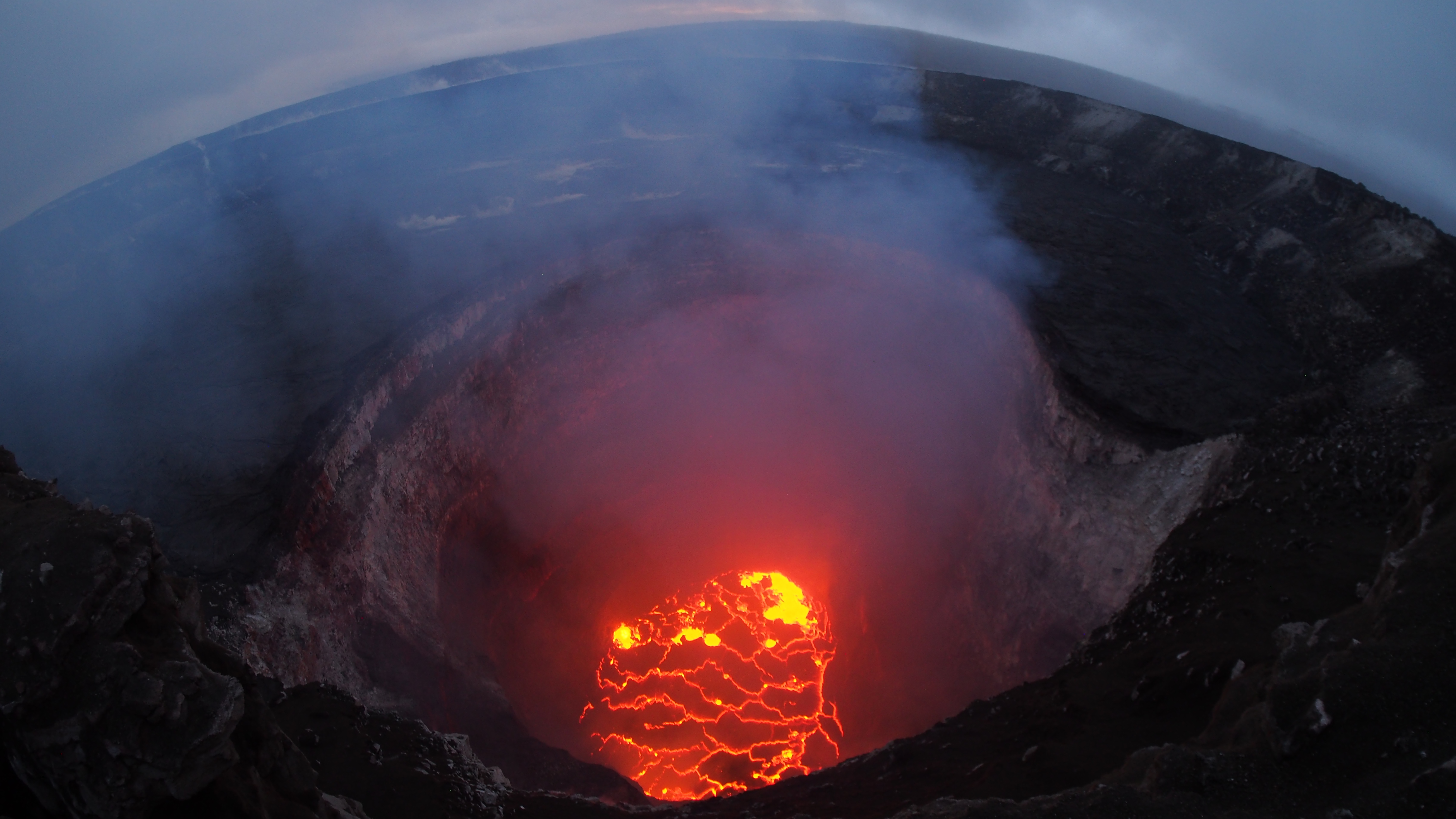
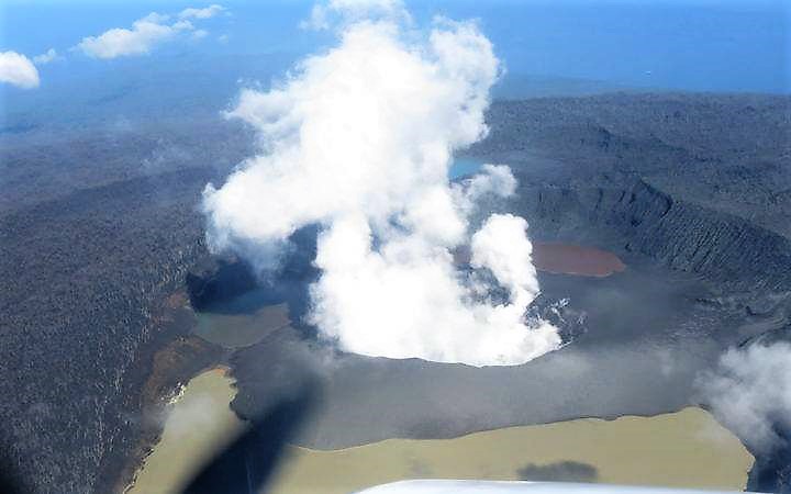
The summit lava lake has dropped significantly over the past few days, and this evening was roughly 220 m below the crater rim. This very wide angle camera view captures the entire north portion of the Overlook crater.
Puʻu ʻŌʻō Observations:
A tiltmeter on the Puʻu ʻŌʻō cone continues to record the deflationary pattern that followed collapse of the crater floor on April 30. Rockfalls from the steep crater walls will likely continue to collapse intermittently, producing small ashy plumes. The 61g lava flow is no longer active.
Hazard Analysis:
Continued eruptive activity (fluctuating and intermittent) in the lower East Rift Zone is likely. New outbreaks or resumption of lava production at existing vents can occur at any time.
Areas downslope of erupting fissures are at risk of lava inundation. The general area of Leilani Estates remains at the greatest risk. However, as the eruption progresses, other areas of the lower East Rift Zone may also be at risk.
Monday, May 7, 2018, 5:59 PM HST (Tuesday, May 8, 2018, 03:59 UTC)
Lower East Rift Zone Eruption
The intermittent eruption of lava in the Leilani Estates subdivision in the lower East Rift Zone of Kīlauea Volcano continues. The location of activity today was focused on the southwest portion of the area.This morning, two new fissure segments broke ground. The first (fissure 11) opened in a forested southwest of Leilani Estates about 9:30 am and was active for only 3 hours. The second (fissure 12) opened about 12:20 between older fissures 10 and 11. By 3:15 pm, both new fissures were in active but the west end of fissure 10 was steaming heavily.
Cracks on Highway 130 widened from 7 cm to 8 cm over the course of the day and additional cracks were found just west of the highway on trend with the eruptive fissures.
Rates of seismicity and deformation changed little throughout the day.
Gas emissions likely remain elevated in the vicinity of fissures.
HVO geologists will be in the area overnight to track and report to Hawaii County Civil Defense on the activity, and other scientists are closely tracking the volcano’s overall activity using various monitoring data streams.
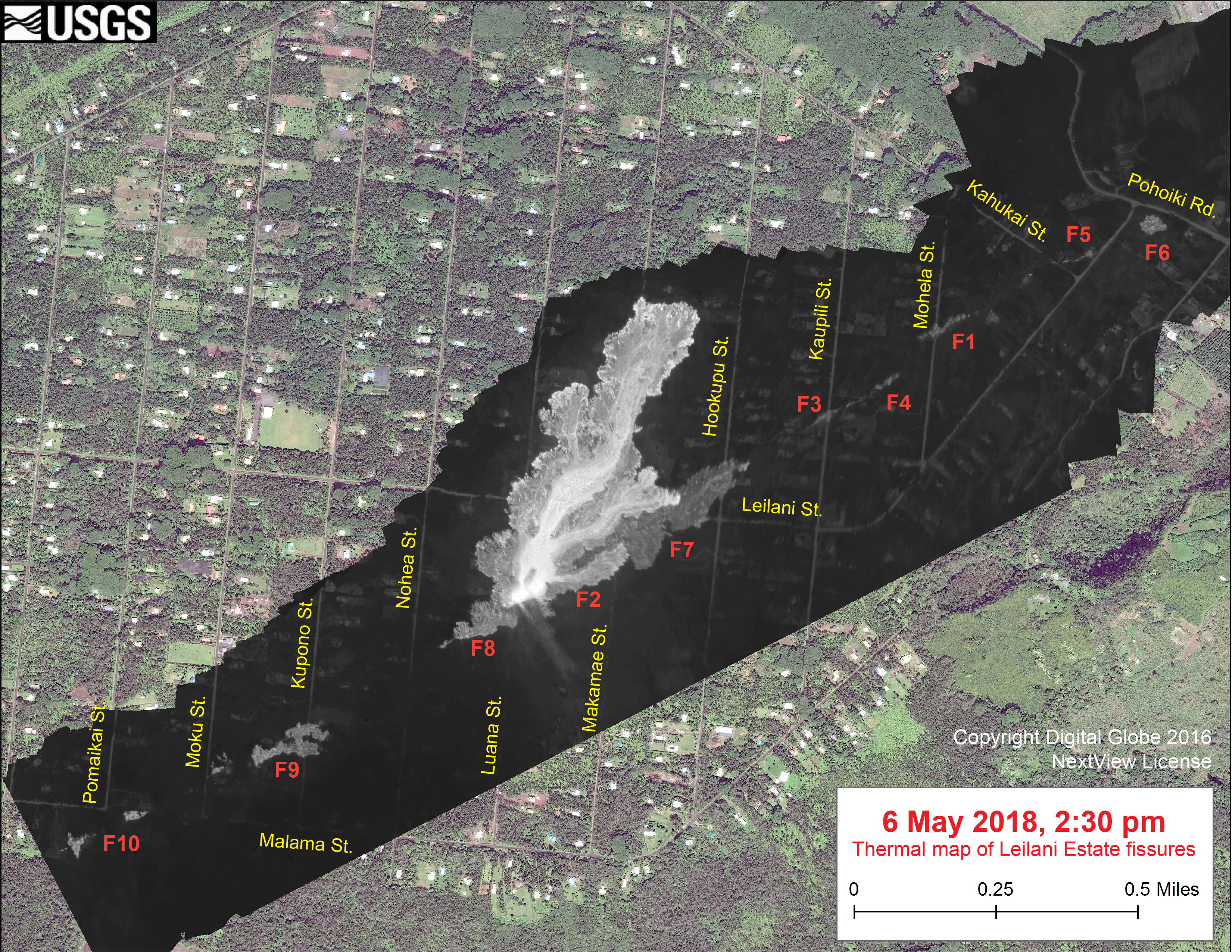
This thermal map clearly shows the ‘a‘ā flow spreading northward (top) from fissure 8 during an overflight of the area this afternoon. The black and white area is the extent of the thermal map. Temperature in the thermal image is displayed as gray-scale values, with the brightest pixels indicating the hottest areas (whitish areas show the active lava flow). The gray linear features are the other fissures (numbered in red color) that have erupted thus far in the sequence. The thermal map was constructed by stitching many overlapping oblique thermal images collected by a handheld thermal camera during a helicopter overflight of the flow field. The base is a copyrighted color satellite image (used with permission) provided by Digital Globe.
Kīlauea Volcano Summit
Tiltmeters at the summit of Kīlauea Volcano continue to record the deflationary trend of the past several days and the lava lake level continues to drop. Rockfalls from the steep crater walls into the retreating lake continue to produce occasional ashy plumes above Halema’uma’u crater. These plumes are expected to continue.
Earthquake activity in the summit remains elevated but has decreased over the past few days. Many of these earthquakes are related to the ongoing subsidence of the summit area and earthquakes beneath the south flank of the volcano.
This message will be updated tomorrow morning or earlier should conditions change.
Source : HVO
Piton de la Fournaise , La Réunion :
Activity bulletin from Monday, May 7, 2018 at 15:30 (local time).
The eruption started on April 27, 2018 at 23:50 local time continues. The intensity of the volcanic tremor (indicator of eruptive intensity at the surface) continues to decrease very gradually (Figure 1).
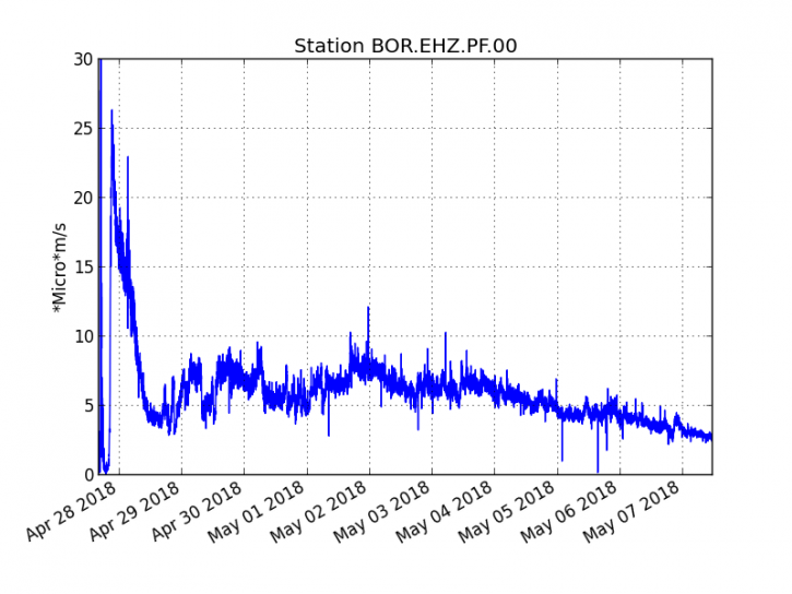
Figure 1: Evolution of RSAM (Indicator of Volcanic Tremor and Eruption Intensity) between 20:00 (16:00 UTC) April 27 and 15:30 (11:30 UTC) May 7 at BOR Seismic Station (at the top) . (© IPGP / OVPF)
The field reconnaissance carried out yesterday and today still report an activity mainly focused on the central vent with a cone now fully closed from which leaks of low lava (less than 10 m above the cone) and from which a main lava tunnel starts. Lava tunnel activity is now in the majority. Few lava flows were visible these past two days, although the front is still active, many fires have been reported at the foot of the rampart and even in the rampart (observations on site from 07/05/2018 to 8:55).
The cone furthest upstream (Figure 2) still projects rare lava projection but these are very weak in intensity.
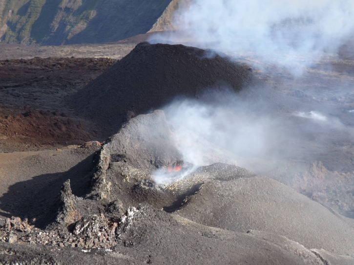
Figure 2: Photograph of the eruptive site on May 6th (14h00 local time). (© IPGP / OVPF)
– The surface flows estimated from the satellite data, via the HOTVOLC platform (OPGC – Clermont Ferrand) and MIROVA (University of Turin), recorded today were between 1 and 2.5 m3 / s.
– Following several days of deflation (deflation) of the volcano, the deformations seem to stabilize and no significant deformation is recorded since.
– A volcano-tectonic earthquake has been recorded in the past 24 hours under the Piton de la Fournaise building.
Alert level: Alert 2-2 – Eruption in the Enclos.
Source : OVPF
Sabancaya , Peru :
Explosive activity increased slightly, averaging 25 explosions / day. Events associated with fluid movements (Long Period type) and ash emissions (Tremor type) have increased. The earthquakes associated with the rise of the magma (Hybrids type) continue to remain low in number and energy.
The eruptive columns of gas and ash reached a maximum height of 2000 m above the crater. The dispersion of these materials occurred within a radius of about 40 km, mainly to the North, Northeast and East.

The volcanic gas (SO2) stream recorded on May 6 had a maximum value of 2662 tons / day, a value considered large.
The volcanic deformation measured in the UBGW station continues to show stability in the deformation curves.
Four thermal anomalies were recorded according to the MIROVA system, with values ranging from 1 MW to 42 MW VRP (Radiated Volcano Power). In general, eruptive activity maintains moderate levels. No significant changes are expected in the following days.
Source : IGP
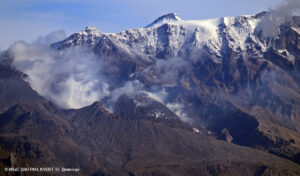
Ambae , Vanuatu :
Latest Ambae eruption produced worst ashfall .
6 MAY 2018. The latest eruption on Ambae island in Vanuatu produced more ash than last year’s event, volcanologists say. Buildings have collapsed under the weight of the ash which has also contaminated water supplies and killed food crops forcing thousands to leave their villages and seek shelter elsewhere on the island.
A decision on whether or not to permanently evacuate Ambae is to be made this week by the Vanuatu Council of Ministers. New Zealand volcanologist, Brad Scott, has been travelling back and forth to Vanuatu supporting local authorities with the monitoring of the volcano.
He said it had undergone three eruption phases since last year and the current one is the worst. « In the first phase the volcanic island was forming in lake Voui. The second phase was more dominated by lava flows making the island larger and growing what we call a scoria cone.
« The third phase was more explosive, creating a large crater and that is where the volcanic ash was coming from that is now impacting the people on the island. »
Source : Radio NZ
Photo: Supplied/ Brad Scott
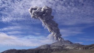
Klyuchevskoy , Kamchatka :
VOLCANO OBSERVATORY NOTICE FOR AVIATION (VONA).
Issued: May 08 , 2018.
Volcano:Klyuchevskoy (CAVW #300260)
Current aviation colour code:ORANGE
Previous aviation colour code:yellow
Source:KVERT
Notice Number:2018-42
Volcano Location:N 56 deg 3 min E 160 deg 38 min
Area:Kamchatka, Russia
Summit Elevation:15580 ft (4750 m)
Volcanic Activity Summary:
An ash plume extended about 105 km to the south-south-east from the volcano is observing on video and satellite images.
Activity of the volcano continues. Ash explosions up to 16,400-19,700 ft (5-6 km) a.s.l. could occur at any time. Ongoing activity could affect low-flying aircraft.
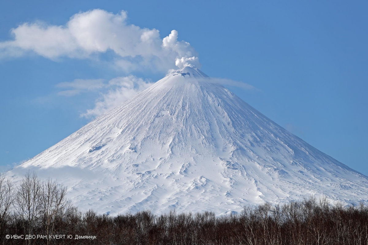
Volcanic cloud height:
16400-18040 ft (5000-5500 m) AMSL Time and method of ash plume/cloud height determination: 20180507/2350Z – Video data
Other volcanic cloud information:
Distance of ash plume/cloud of the volcano: 65 mi (105 km)
Direction of drift of ash plume/cloud of the volcano: SSE / azimuth 159 deg
Time and method of ash plume/cloud determination: 20180507/2350Z – Himawari-8
Source : Kvert
Photo : Yu. Demyanchuk, IVS FEB RAS, KVERT , 15/4/2018 .