April 19 , 2018.
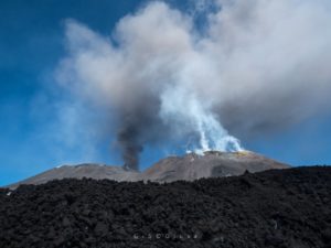
Copahue , Chile :
During this period, twenty (20) seismic events classified as volcano – tectonic (VT) were recorded, associated with fracturing processes of rigid materials. The event of greatest energy had a local magnitude (ML) equal to M2.0 and was located 5.3 km in the northeast direction (NE) of active crater El Agrio, at a depth of 4.7 km.
Similarly, 48 earthquakes associated with fluid dynamics within the volcano were recorded and cataloged as long-period events, with reduced maximum displacement values of 2.7 cm2.
The bottom tremor series showed fluctuating trends, although from the beginning of the month until March 12, it showed a continuous downward trend, reaching reduced displacement levels (DRCs) close to 0.5 cm2 (low value). After that, the tremor showed an upward trend reaching values close to 6 cm2 (moderate value).
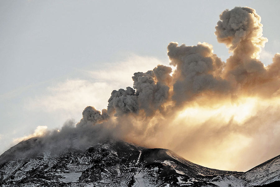
IP cameras installed in the vicinity of the volcano recorded constant degassing from the active crater (El Agrio) with a maximum height of 270 m. (April 2).
According to the data provided by the two active GNSS stations installed on the volcano, there are variations which differ on the historical behavior of the monitoring points, which may indicate a surface deformation of less than 0.5 cm, an increase due to variations in the internal dynamism of the volcano produced between the months of December 2017 and March 2018 in the nearest station of the active crater.
Sulfur dioxide (SO2) emissions from the Differential Absorption Spectrometry Equipment (DOAS) at Mellizas Station, located 5 km east-northeast (ENE) of the active crater, show an average value for the period of 765 ± 100 t / d, and a maximum daily value of 1001 t / d reported on April 5th. S02 emissions are in normal levels for this volcano.
No thermal warnings were reported in the area associated with the volcanic building during the second half of the year, according to the data processed by the Infrared Medium Observation of Volcanic Activity (MIROVA).
As mentioned in the RAV corresponding to the month of March, this activity is part of a process that starts at the end of November 2017 with the recording of earthquake swarms of type VT, seismicity which is present in smaller quantity and magnitude. At the same time, VLP-type seismicity is re-recorded with the increase of the series of tremors. The whole process could be related to the deformation recorded by the GNSS equipment, which follows a magmatic contribution of the deep layers, which induces interaction with the hydrothermal system that can produce small phreatic explosions. On the other hand, if the magmatic system reaches higher levels, the activity could evolve to continuous ash emissions or Strombolian activity, which has been recorded in previous years.
In this scenario, the danger of explosions that may affect areas near the crater persists, therefore the alert level is maintained at:
YELLOW LEVEL: Changes in the behavior of volcanic activity – Probable time for an eruption: WEEKS / MONTH.
Observation: It is recommended to apply precautionary access restrictions to an area close to the crater with a radius of 1 km.
Source : Sernageomin.
Photos : Archives Sernageomin
Nevados de Chillan , Chile :
Volcanic Activity Report (RAV), Volcanological Observatory of the Southern Andes – Ovdas
Date: April 18, 2018 5:00 PM HL.
Current alert level: ORANGE
1. Volcanic monitoring
1.1 Seismic activity:
In the past 24 hours, the Nevados del Chilian volcanic complex has continued to exhibit long-period (LP) earthquakes and tremor (TR) episodes related to the occurrence of explosions, most of them with seismic energies considered moderate. Activity levels remained very close to levels reported for the previous period. In addition, there was a low occurrence of volcano-tectonic activity of moderate magnitude.
1.2 Surface activity
Maximum height of the column (km): 0.4.
Direction: East.
Main distance Panache (km): not detected.
Source of information: OVDAS IP camera
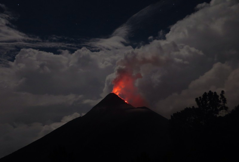
Incandescence (yes / no): Yes.
Observations:
The gas columns observed from the IP cameras had a pulsatile behavior. They were weak and had a mainly whitish coloration, with preferential dispersion towards the East. We also observe intermittent nighttime glow and ballistic emission around the active crater associated with explosions.
1.3 Other observations
Infrasound sensors recorded during the period acoustic signals due to explosions with amplitudes lower than 0.3 pascals (Pa) reduced to 1 km.
⦁ Thermal radiation data processed by the MIROVA group did not report any thermal anomalies on Nevados del Chilian.
⦁ From geodetic data recorded between 01 and 15 April, provided by 5 GNSS equipments and two electronic inclinometers (IE) which measure the deformation of the complex, we observe subtle variations in the trends and displacements of each station. Also visible in the lines crossing the crater, associated with the activity recorded since December 2017 to date.
⦁ Sulfur Dioxide (SO 2) emissions recorded between April 1 and April 15 by the Differential Absorption Spectrometry (DOAS) equipment corresponding to Chilian Station, located 2.6 km to the southeast (SE) of the active crater, has a monthly average value of 332 ± 61 t / d and a maximum daily value of 778 t / d reported on April 7th. S02 emissions are at low levels for this volcano, consistent with the presence of the lava dome.
Source : Sernageomin.
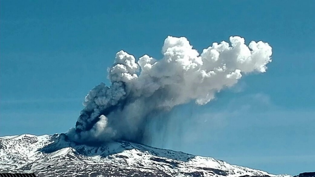
Fuego , Guatemala :
Type of activity: Vulcanian
Morphology: Composite Stratovolcano.
Location: 14 ° 28’54˝ Latitude N; 90 ° 52’54˝ Longitude W.
Height: 3,763msnm.
Weather conditions: Cloudy
Wind: North at 5 km / h
Precipitation: .0.0 mm
Activity:
Presence of a low white degassing fumarose at a height of 4600 meters, dispersed to the west, south and north. 6-8 weak to moderate explosions per hour are observed which eject columns of ash at a height of 4600 to 4800 m (15090 -15,750 feet) that are scattered 12 to 15 km to the West, Southwest and South.
Incandescent pulses 200-300 m above the crater cause weak and moderate avalanches to the Seca, Ceniza, Honda and Las Lajas gullies. The explosions were accompanied by loud to moderate rumblings and some with a shock wave causing vibrations in the roofs of houses near the volcano, the sounds are similar to jet engines with intervals of 8 to 15 minutes. The fall of fine ash particles is generated in the areas of Panimache I, Morelia, Santa Sofia, Sangre de Cristo, Palo Verde, El Porvenir, Yepocapa and others.
Source : Insivumeh.
Photo : inconnu.
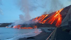
Ambae , Vanuatu :
15.4°S, 167.83°E
Elevation 1496 m
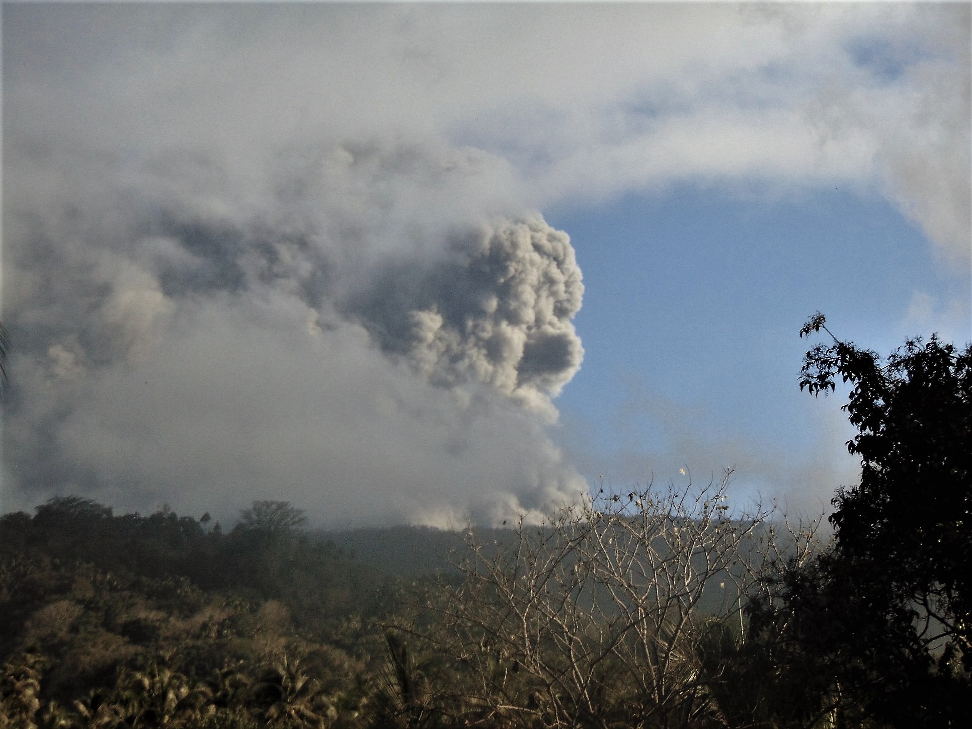
Based on observations from satellites, webcams, pilots, and the Vanuatu Geohazards Observatory (local community reports), the Wellington VAAC reported that during 11-14 April ash plumes from the vent at Ambae’s Lake Voui rose to altitudes of 1.8-4.9 km (6,000-16,000 ft) a.s.l. and drifted N, NW, W, and SE. On 12 April news articles noted that ashfall had affected the N part of Ambae, with photos showing thick ashfall deposits on houses and agricultural land, and reports of contaminated water supplies. On 15 April a VAAC office reported that the eruption has ceased. The Alert Level remained at 3 (on a scale of 0-5).
Police deployed to Vanuatu’s Ambae ahead of mass evacuation – RNZ
17 APRIL 2018. A patrol boat loaded with police and mobile force personnel is being deployed to the Vanuatu island of Ambae this afternoon to help with a mass evacuation.
Ambae volcanoAmbae volcano Photo: Vanuatu Geohazards Department
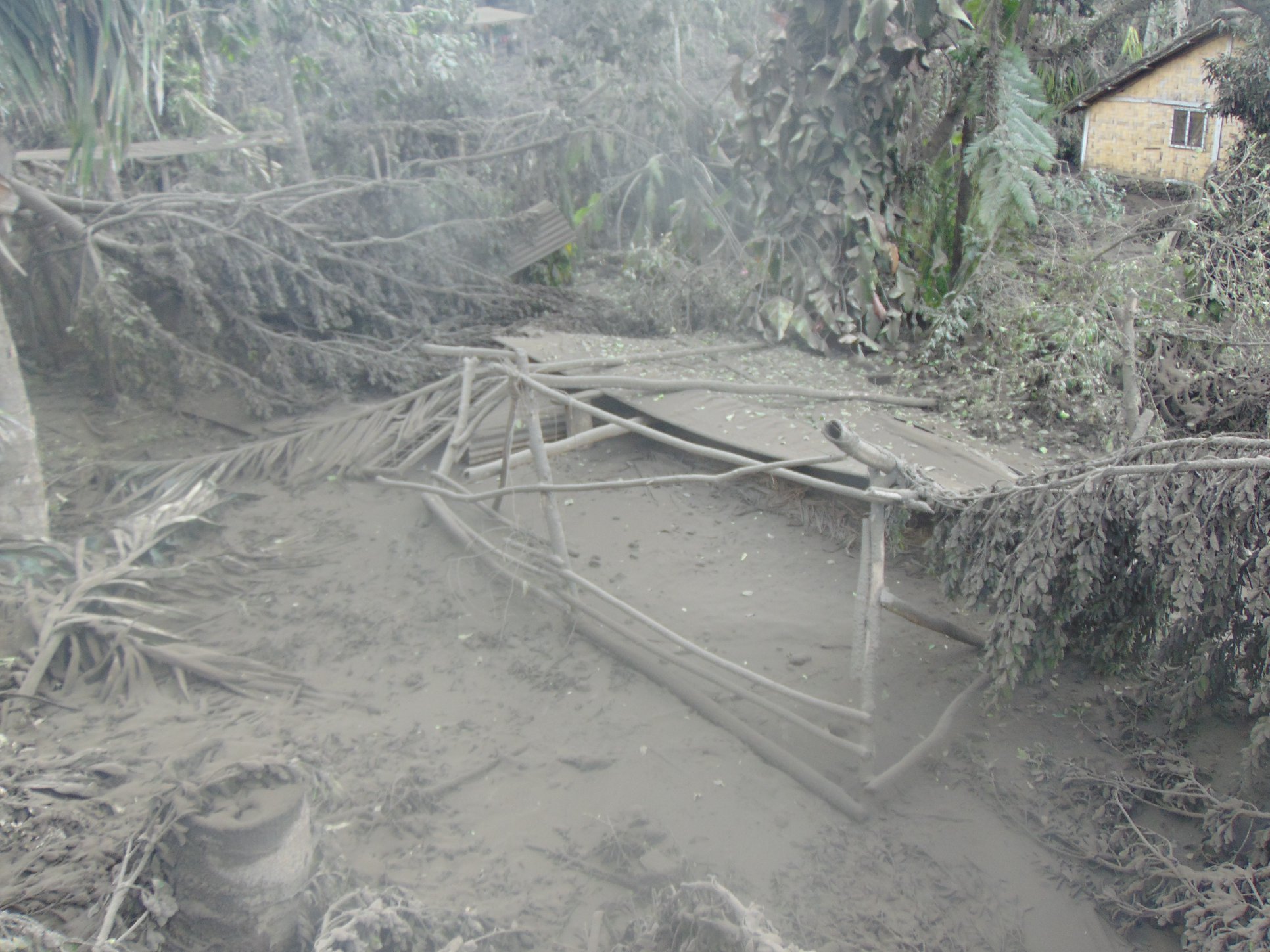
A state of emergency has been declared on the island, with the volcano at the island’s centre continuing to erupt, blanketing much of the island in ash.
The government announced last week that a mass evacuation would again take place, with people from the islands north, west and south being moved to the far east coast or nearby smaller islands.
A spokesperson for the National Disaster Management Office, Presley Tari, said food supplies are being distributed by the provincial government, and the patrol boat is leaving Port Vila today.
Mr Tari said the mass evacuation will begin once the forces arrive and establish themselves which is likely to be later on this week.
Ambae is in Penama Province and the provincial government has secured land on the island’s east side for victims of the ongoing eruption.
This comes as the central government’s ministerial task force is still yet to complete negotiations to acquire land for resettlement on either Maewo or Pentecost – the two closest islands.
The Penama Provincial president, Alban Garaevui, said his government has made the first installment of $US9,386 dollars to a custom landowner, so people who will move from Ambae can live there and develop gardens.
Landowner Stevenson Vusilai said he couldn’t be happy while others on Ambae Island continue to suffer from the volcanic ash fall. Traditionally the east of Ambae has been the safest part of the island during eruptions, but wind changes have carried the ash in that direction as well. Reports from the island confirmed that ash is continuing to fall.
Sources: ABC News – Société australienne de radiodiffusion, Centre consultatif sur les cendres volcaniques de Wellington (VAAC) , GVP . RNZ .
Photo : William S. Mala.