April 18 , 2018.
Fuego , Guatemala :
SPECIAL VULCANOLOGICAL BULLETIN, GUATEMALA, APRIL 16, 2018, 9:00 pm (local time)
INCREASE IN ACTIVITY AND FLOW OF LAVA ON FUEGO VOLCANO.
Type of activity: Vulcanian
Morphology: Composite stratovolcan
Location: 14 ° 28’54˝ Latitude N; 90 ° 52’54˝ Longitude W.
Altitude: 3,763msnm.
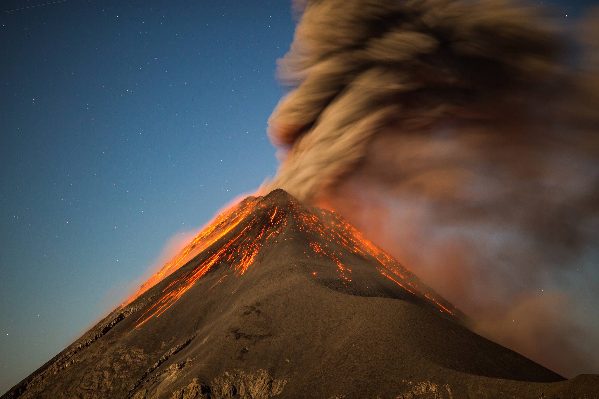
The National Institute of Seismology, Volcanology, Meteorology and Hydrology (Insivumeh) stated that the volcano expels a thick column of ash at about 4,800 meters above sea level that is scattered about 20 kilometers to the west and the south-west of the volcanic cone.
As has been reported, the Fuego volcano maintains a high level of explosion, with an interval of 7 to 10 per hour, characterized as moderate to heavy, expelling the thick ash columns at a height of 4,800 m. (15,748 feet) which are scattered by the winds towards the South, the West, for a distance of 20 kilometers. This activity generates a 1300 meter lava flow, in the direction of Canyon Seca on the west flank of the volcano, which can extend over the hours, with probabilities that others are generated in other ravines. The GR3 seismic stations recorded explosions and tremors (internal vibration) The explosions generate loud rumblings and moderate shock waves, which causes vibrations in the roofs and windows of houses in the villages of Panimache, Morelia, La Reina, Alotenango and others. The activity presented by the Fuego volcano is high, and there is the probability of generation of other lava flows, and even enter the eruption phase in a few hours or days.
Source : Insivumeh.
Photo : Ivan Bustor ( http://ivanbustor.com/blog/acatenango-volcano-fuego-active-eruption-guatemala-adventure )
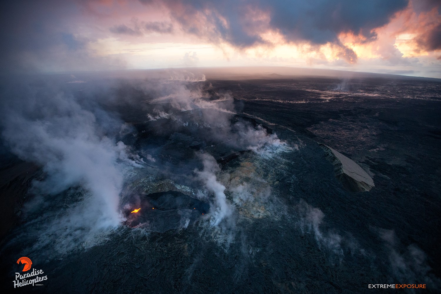
Pu‘u ‘Ō‘ō , Hawai :
HVO/USGS Volcanic Activity Notice
Current Volcano Alert Level: WATCH
Current Aviation Color Code: ORANGE
Issued: Tuesday, April 17, 2018, 1:10 PM HST
Source: Hawaiian Volcano Observatory
Notice Number:
Location: N 19 deg 25 min W 155 deg 17 min
Elevation: 4091 ft (1247 m)
Area: Hawaii
Volcanic Activity Summary:
Observations and measurements of the Pu‘u ‘Ō‘ō eruption on Kīlauea Volcano’s East Rift Zone during the past month suggest that the magma system beneath Pu‘u ‘Ō‘ō has become increasingly pressurized. If this activity continues, a new vent could form at any time, either on the Pu‘u ‘Ō‘ō cone or along adjacent areas of the East Rift Zone.
Recent Observations.
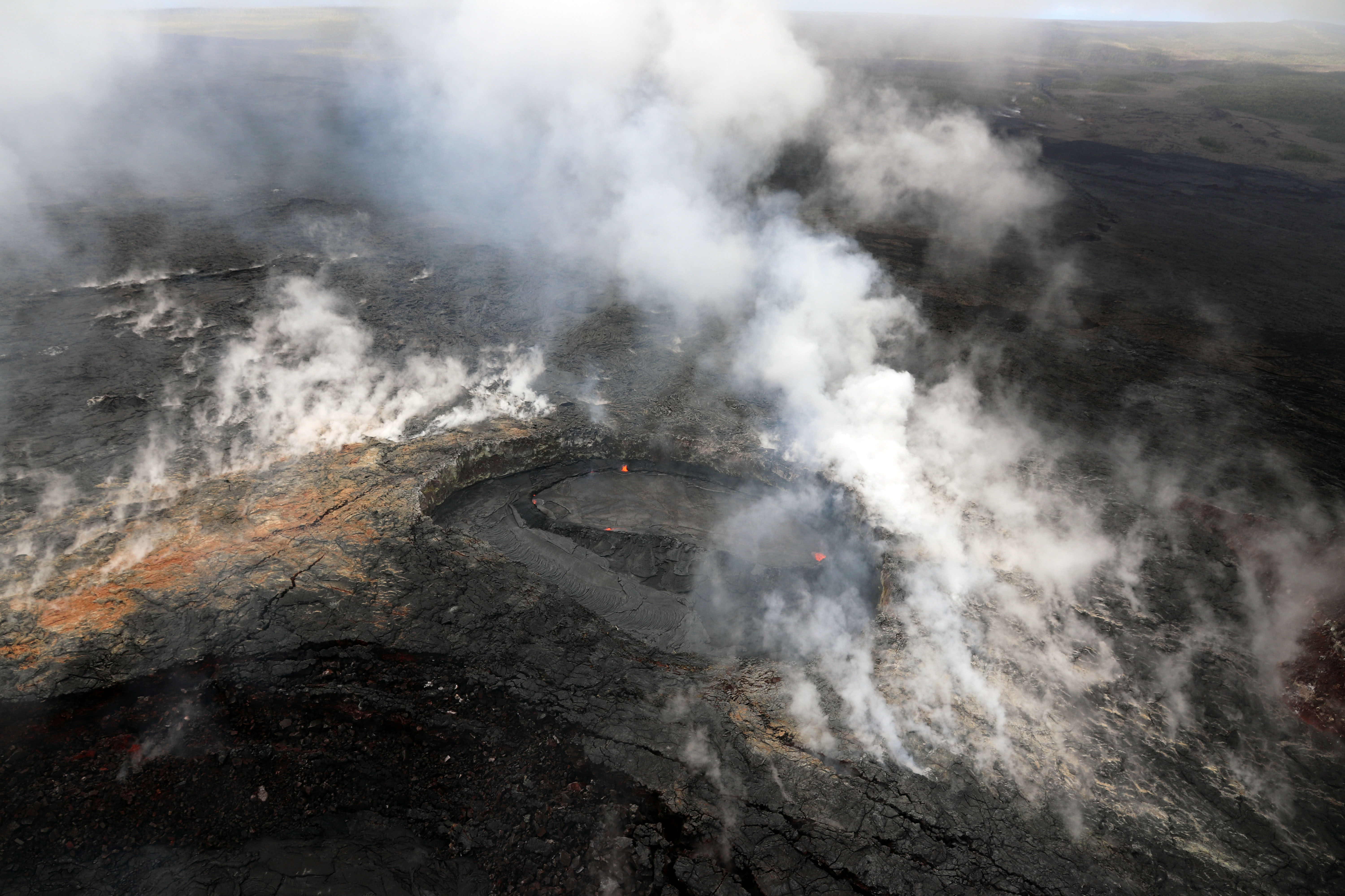
The Pu‘u ‘Ō‘ō eruption continues to supply lava to the 61g flow and the lava pond within the Pu‘u ‘Ō‘ō crater. As of April 13, 2018, geologists observed scattered breakouts from the 61g flow within about 2.2 km (1.4 miles) from Pu‘u ‘Ō‘ō and a sluggish breakout about 5 km (3.1 miles) from Pu‘u ‘Ō‘ō. During the past few weeks, lava flows have also erupted onto the Pu‘u ‘Ō‘ō crater floor.
Since mid-March 2018, a tiltmeter and GPS station on Pu‘u ‘Ō‘ō have recorded a pronounced inflationary trend of the cone, and recent webcam images have detected simultaneous uplift of the Pu‘u ‘Ō‘ō crater floor by several meters (yards). These observations provide evidence that magma is accumulating at shallow depths beneath Pu‘u ‘Ō‘ō.
Similar episodes of inflation and uplift of the crater floor at Pu‘u ‘Ō‘ō occurred in May–June 2014 and May 2016. These episodes preceded the opening of new vents on Pu‘u ‘Ō‘ō that produced the June 27th flow (active 2014-2016) and the 61g flow (active since 2016), respectively.
Breakouts from the 61g lava flow are located close to Pu‘u ‘Ō‘ō and above the Pulama pali within the Kahaualeʻa Natural Area Reserve (NAR) and Hawai‘i Volcanoes National Park, respectively. Because of volcanic hazards, the Hawaii Department of Land and Natural Resources has restricted public access to the Kahauale‘a NAR since 2007 (https://dlnr.hawaii.gov/ecosystems/nars/hawaii-island/kahaualea-2/). Areas within the National Park are also closed (see https://www.nps.gov/havo/closed_areas.htm for more info on these closures).
Hazard Analysis:
A new vent located on the cone of Pu‘u ‘Ō‘ō would erupt lava flows onto one or more sides of the cone that would initially advance downslope rapidly within a few kilometers (miles) from the vent. Because of the potential for a sudden breakout anywhere on Pu‘u ‘Ō‘ō, the cone is extremely hazardous. The location of a new vent or potential lava-flow paths cannot be estimated until such time that a new vent forms and stabilizes.
Remarks: Kīlauea Volcano’s East Rift Zone eruption began in January 1983 with high lava fountains that built a cinder-and-spatter cone, later named Pu‘u ‘Ō‘ō. Subsequent activity included continuous lava effusion from vents on Pu‘u ‘Ō‘ō or within a few kilometers (miles) east or west of Pu‘u ‘Ō‘ō. Most of the lava flows erupted from these vents have advanced down the south flank of Kīlauea, often reaching the ocean.
A new vent that opened on the northeast flank of Puʻu ʻŌʻō on June 27, 2014, sent a lava flow (informally called the June 27th flow) 20 km (12.4 miles) to the northeast and into Pāhoa, a town in the Puna District of the Island of Hawai‘i. This lava flow persisted until early March 2015, when all activity near Pāhoa ceased.
On May 24, 2016, the opening of a new vent on the east flank of Puʻu ʻŌʻō led to the demise of the June 27th vent and flow, and sent a new lava flow (61g flow) south-southeast toward the ocean. The flow advanced about 10 km (6.2 miles), reaching the ocean on July 26, 2016. Lava stopped flowing into the ocean in early November 2017, after which surface flows have progressively retreated to near-vent areas above the Pulama pali.
Source : HVO
Photos : Bruce Omori , HVO.
Chiles / Cerro Negro , Chile :
Subject: Activity bulletin of Chiles and Cerro Negro volcanoes
The level of activity of volcanoes is maintained at the level:
YELLOW LEVEL ■ (III): CHANGES IN THE BEHAVIOR OF VOLCANIC ACTIVITY.
Following the activity of VOLCANS CHILES and CERRO NEGRO, the COLOMBIAN GEOLOGICAL SERVICE (SGC) reports that:
For the period from 10 to 16 April 2018, seismicity in the Chiles – Cerro Negro volcanoes region maintained similar levels of occurrence to those recorded the previous week, with the predominance of events associated with fracturing processes of cortical material . As of April 10, the daily average is 220 earthquakes, most of them having magnitudes less than 1.5 on the Richter scale. The earthquake of magnitude M2.9 recorded on April 15 at 3:32 pm, 5.2 km southwest of the volcano was then reported as felt by residents of the community of Chiles, in the municipality of Cumbal.
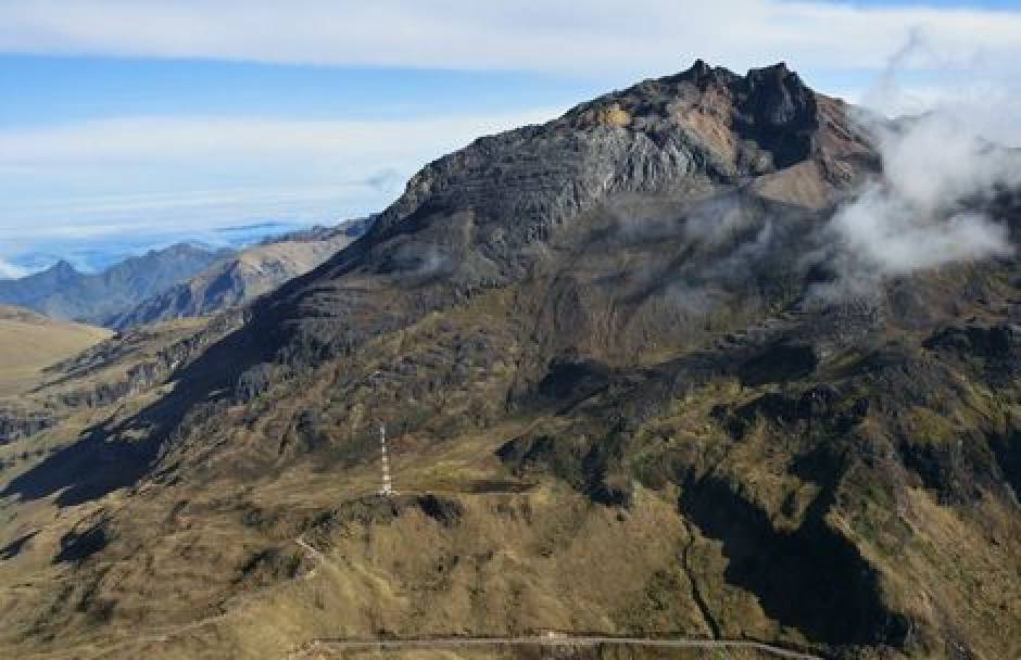
It is pointed out that the occasional recording of earthquakes which are related to the movements of fluids within the volcanic system continues, without the presence of surface manifestations so far.
The COLOMBIAN GEOLOGICAL SERVICE and the GEOPHYSICAL INSTITUTE OF THE NATIONAL POLICY SCHOOL OF ECUADOR closely monitor the evolution of this seismic activity and the volcanic phenomenon and will inform timely changes detected.
Source : SGC
Kanlaon , Philippines :
KANLAON VOLCANO BULLETIN 18 April 2018 08:00 A.M.
Kanlaon Volcano’s seismic monitoring network recorded two (2) volcanic earthquakes during the past 24 hours. Moderate to voluminous emission of white to dirty white steam-laden plumes that rose 1200 meters from the summit before drifting northwest to northeast was observed. Ground deformation data from continuous GPS measurements indicate a more pronounced inflation of the edifice since December 2015, signifying pressurization deep beneath the edifice. Sulfur dioxide (SO2) emission was measured at an average of 1589 tonnes/day on 17 April 2018.
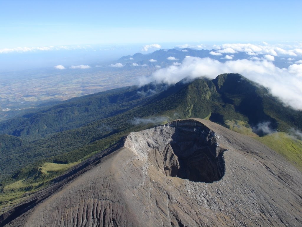
Alert Level 2 status prevails over Kanlaon Volcano, which means that the volcano is undergoing a moderate level of unrest due to probable intrusion of magma at depth that may or may not lead to a magmatic eruption. The local government units and the public are strictly reminded that entry into the 4-kilometer radius Permanent Danger Zone (PDZ) is strictly prohibited due to the further possibilities of sudden and hazardous steam-driven or phreatic eruptions. Civil aviation authorities must also advise pilots to avoid flying close to the volcano’s summit as ejecta from any sudden phreatic eruption can be hazardous to aircraft.
DOST-PHIVOLCS is closely monitoring Kanlaon Volcano’s activity and any new development will be relayed to all concerned.
Source : Phivolcs