March 04 , 2018.
Kilauea, Hawai :
19°25’16 » N 155°17’13 » W,
Summit Elevation 4091 ft (1247 m)
Current Volcano Alert Level: WATCH
Current Aviation Color Code: ORANGE
Activity Summary:
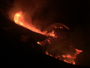
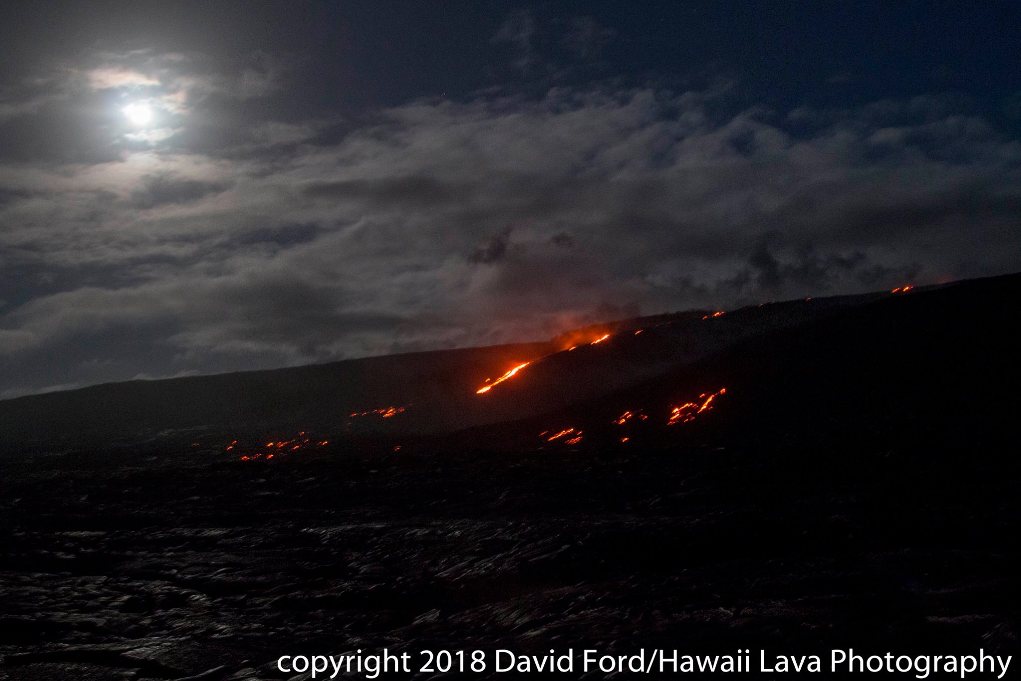
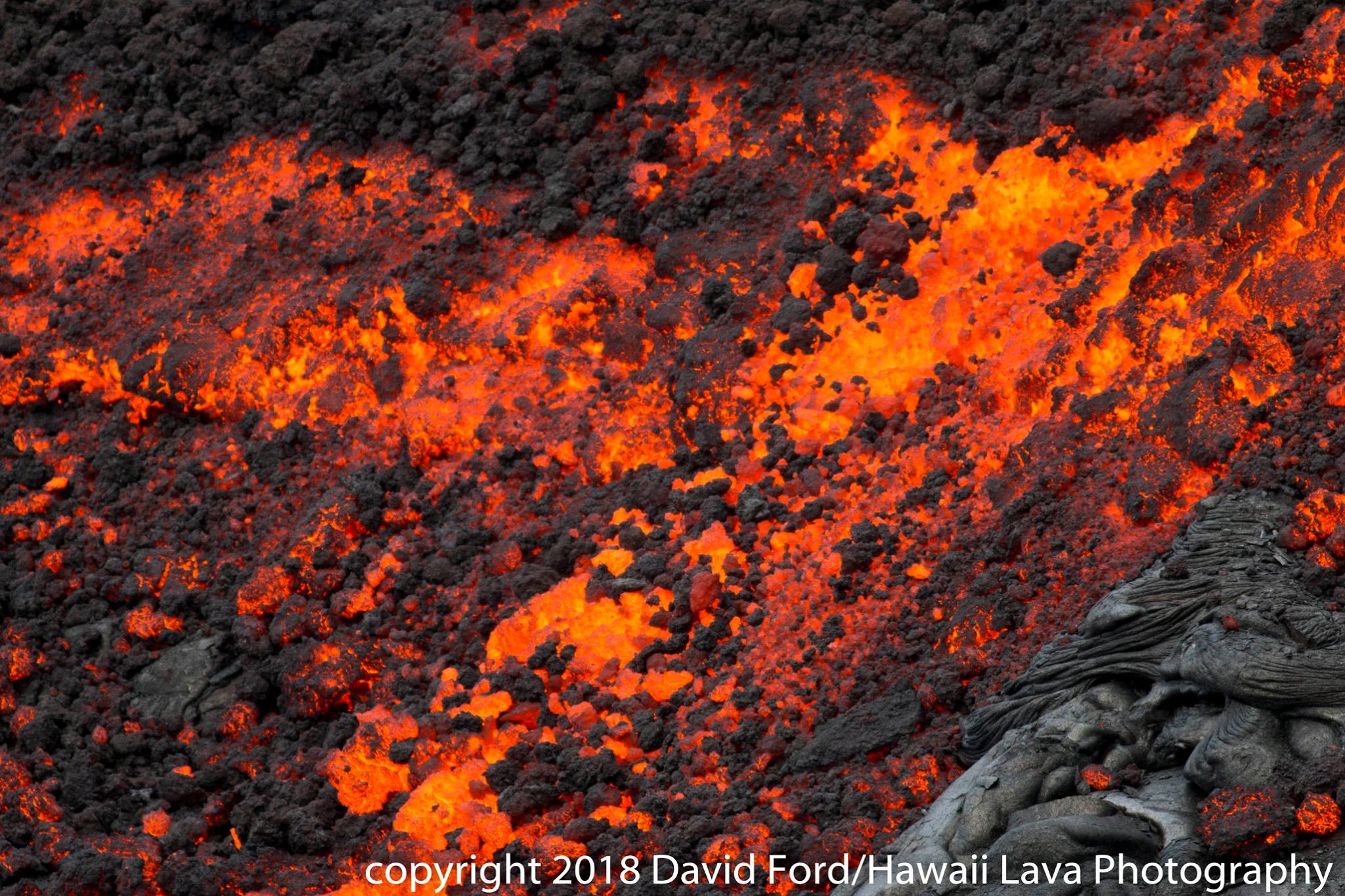
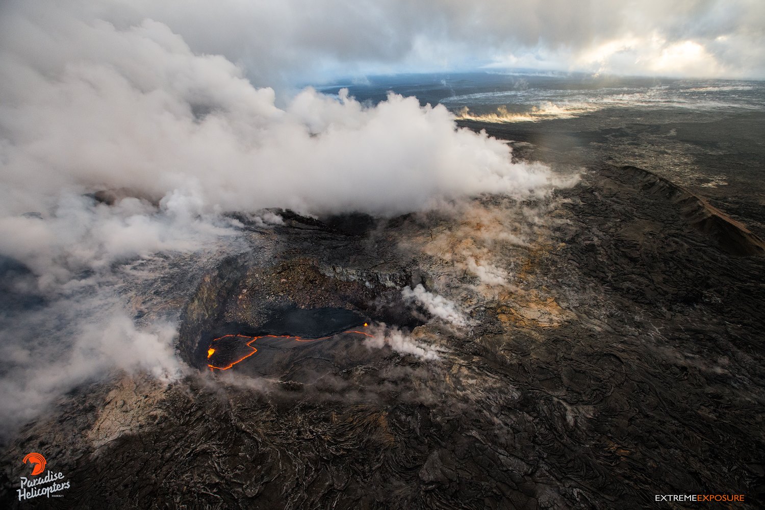
Eruptions at Kīlauea Volcano’s summit and East Rift Zone continue with no significant changes. The Episode 61g lava flow continues to produce surface flows on the upper portion of the flow field and on Pulama pali. Lava is not entering the ocean at this time. These lava flows pose no threat to nearby communities. The summit lava lake is about 38 m (125 ft.) below the floor of Halemaʻumaʻu. Low rates of ground deformation and seismicity continue across the volcano.
Summit Observations:
Summit tiltmeters recorded the switch to deflationary til at about 2:45 pm yesterday, consistent with the deflation phase of a summit DI event (see definitions below). The height of the summit lava lake dropped since the the start of summit deflation and was estimated to be about 35 m (125 ft.) below the rim of the Overlook crater this morning. There was a brief flurry of small earthquakes in the upper East Rift Zone yesterday evening but, otherwise,. Seismicity is within normal, background rates, with tremor fluctuations associated with lava lake spattering. Summit sulfur dioxide emission rates remain high.
Puʻu ʻŌʻō Observations:
Rainy weather has made for difficult viewing conditions, nonetheless webcam images over the past 24 hours show persistent glow at long-term sources within the crater and from a small lava pond on the west side of the crater. There were no significant changes in seismicity or tilt over the past 24 hours. The sulfur dioxide emission rate from the East Rift Zone vents has been steady over the past several months and remains significantly lower than the summit emission rate.
Lava Flow Observations:
The episode 61g flow is still active, but no lava is flowing into the ocean. Webcams show continuing surface flow activity on the upper portion of the flow field and on Pulama pali. None of these flows poses any threat to nearby communities at this time.
Source : HVO.
Photos : David Ford , Bruce Omori.
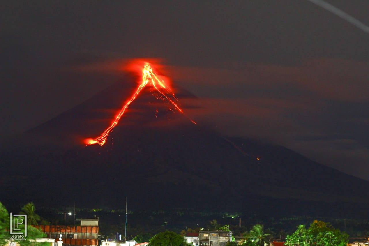
Mayon , Philippines :
MAYON VOLCANO BULLETIN 04 March 2018 08:00 A.M.
Mayon’s activity in the past 24 hours was characterized by minor degassing events, lava effusion and fountaining from the summit crater. A total of 68 degassing events between 3:09 PM and 10:02 PM generated 500 meter-tall grayish ash plumes that drifted southwest. Three (3) episodes of lava-collapse pyroclastic density currents (PDC) were visually observed between 9:39 AM and 3:10 PM yesterday on the Miisi and Basud Gullies within 4-5 kilometers of the summit crater. From 1:59 AM to 7:30 AM, sixteen (16) discrete episodes of lava fountaining lasting three (3) to twenty-three (23) minutes were seismically detected, accompanied by rumbling sounds audible beyond 10 kilometers of the summit. At night, lava flows were observed to continue moving downslope within 3.3 kilometers, 4.5 kilometers and 1.9 kilometers from the crater on the Miisi, Bonga and Basud Gullies, respectively.
A total of one hundred thirty-three (133) volcanic earthquakes and thirty (30) rockfall events were recorded by Mayon’s seismic monitoring network. Sulfur dioxide (SO2) emission was measured at an average of 1,403 tonnes/day on 02 March 2018. Deflation of the lower slopes that began on 20 February is still being recorded by electronic tilt. Nonetheless, overall electronic tilt and continuous GPS data indicate that the edifice is still swollen or inflated relative to November and October 2017, consistent with campaign Precise Leveling data acquired last week.
Alert Level 4 still remains in effect over Mayon Volcano. The public is strongly advised to be vigilant and desist from entering the eight (8) kilometer-radius danger zone, and to be additionally vigilant against pyroclastic density currents, lahars and sediment-laden stream flows along channels draining the edifice. Civil aviation authorities must also advise pilots to avoid flying close to the volcano’s summit as ash from any sudden eruption can be hazardous to aircraft.
DOST-PHIVOLCS maintains close monitoring of Mayon Volcano and any new development will be communicated to all concerned stakeholders.
Source : Phivolcs.
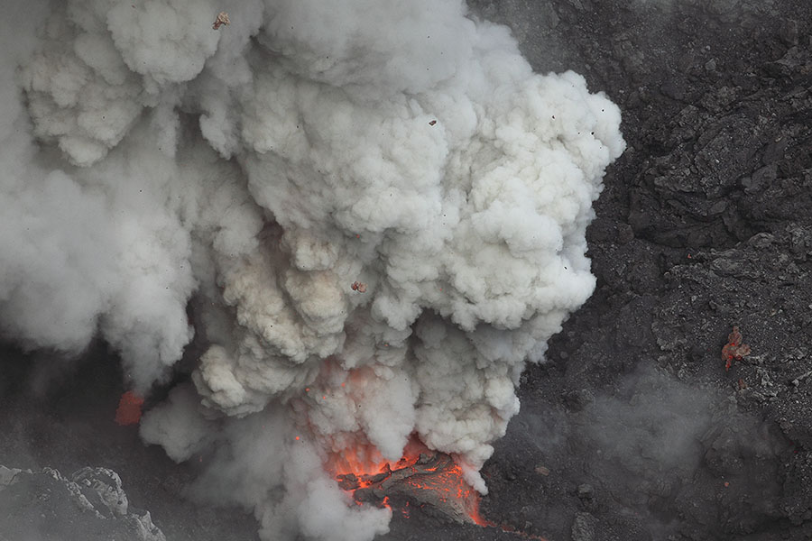
Dukono , Indonesia :
Since yesterday until this morning visually the summit of the volcano is often covered with fog. A column of gray ash, high pressure is observed, rising between 300 and 600 m. The wind is oriented to the east.
The seismographs, dated 03 March 2018 recorded:
A continuous tremor associated with an eruption of ash with an amplitude of 0.5 to 18 mm (dominant value of 2 mm).
Recommendation:
Communities around G. Dukono and visitors / tourists should not move, climb or approach Malupang Warirang crater within 2 km.
VOLCANO OBSERVATORY NOTICE FOR AVIATION – VONA.
Issued: March 04 , 2018.
Volcano:Dukono (268010)
Current Aviation Colour Code: ORANGE
Previous Aviation Colour Code: orange
Source: Dukono Volcano Observatory
Notice Number: 2018DUK27
Volcano Location: N 01 deg 41 min 35 sec E 127 deg 53 min 38 sec
Area: North Maluku, Indonesia
Summit Elevation: 3933 FT (1229 M)
Volcanic Activity Summary:
Eruption with volcanic ash cloud at 23h38 UTC (08h38 local).
Volcanic Cloud Height:
Best estimate of ash-cloud top is around 5213 FT (1629 M) above sea level, may be higher than what can be observed clearly. Source of height data: ground observer.
Other Volcanic Cloud Information:
Ash cloud moving to South.
Remarks:
Eruption and ash emission is continuing.
Source : Magma , VSI.
Photo : Photovolcanica
Popocatépetl , Mexico :
Update March 3, 11:00 am (March 3, 5:00 pm GMT)
In the past 24 hours, the monitoring systems of the Popocatepetl volcano, have identified 65 low intensity exhalations, sometimes accompanied by steam and gas, five explosions at 16:09 pm, 22:21 pm, 22:48 pm yesterday and today at 03:34 h, 09:51 h, and a volcano-tectonic event at 1:44 with a magnitude of M1.3. In addition, 18 minutes of harmonic tremor of low amplitude were recorded.
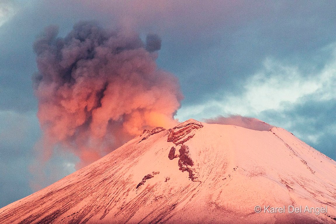
During this report, a low emission of water vapor and gas is observed as the winds disperse to the North.
CENAPRED asked not to approach the volcano and in particular the crater, because of the risk of falling of projectiles, and in case of heavy rain to stay away from ravine bottoms because of the risk of landslides and floods. mud.
The Popocatepetl volcanic warning light is located at Amarillo Phase 2.
Source : Cenapred
Photo : Karel Del Angel
Yellowstone , United-States :
Yellowstone’s dynamic Norris Geyser Basin , February 26, 2018.
Yellowstone Caldera Chronicles is a weekly column written by scientists and collaborators of the Yellowstone Volcano Observatory. This week’s contribution is from Jennifer Lewicki, research geologist with the U.S. Geological Survey in Menlo Park, CA.
Ever wonder what makes the Norris Geyser Basin in Yellowstone National Park so special? It turns out that the basin not only boasts the hottest temperatures and largest changes in hydrothermal (hot water) activity in the National Park, but is also home to Steamboat Geyser, which erupts to unmatched heights of up to 100 m (328 ft).
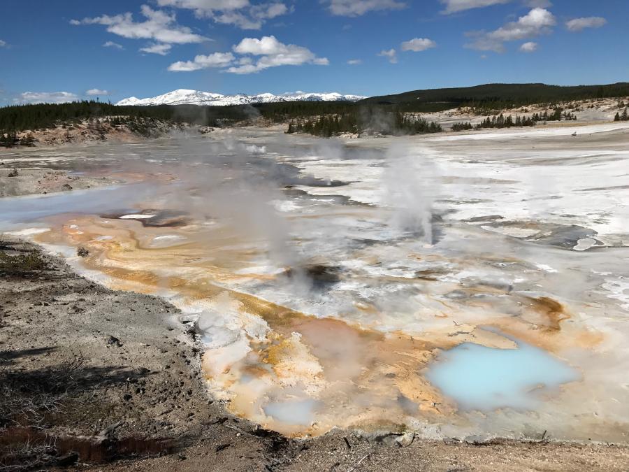
View of Norris Geyser Basin
Norris Geyser Basin is also changing all the time, which makes it one of the most interesting thermal areas in the Park. These changes can involve unusual boiling, chemical changes to water, variations in spring activity, and increases in acidity and cloudiness of certain hot springs and geysers. A recent example is activity of Echinus Geyser, which, for a few weeks during October-November 2017, erupted every 2-3 hours, instead of its more usual intermittent activity.
A more noteworthy change occurred in 2003, when the southern part of Norris Geyser Basin, known as the Back Basin, attracted the attention of both scientists and visitors. Dramatic increases in hydrothermal activity occurred over a period of several months. Ground and water temperatures rose, water in some thermal pools boiled away and left hissing steam vents, new mud pots (depressions filled with boiling acidic water and mud) formed, and vegetation died and burned. Porkchop Geyser, inactive since 1989, increased markedly in temperature and then sprang back to life in an eruption. These changes motivated increased monitoring of seismicity and deformation by University of Utah scientists, and Yellowstone National Park ordered the temporary closure of the Back Basin to visitors to protect the public and park staff from hazards that could result from unusually high ground and water temperatures. It is still a mystery as to why the 2003 increase in hydrothermal activity was so extreme.
Norris Geyser Basin also hosts several craters that reach up to 100 m (328 feet) in diameter. These craters were formed during hydrothermal explosions that ejected boiling water, mud and rocks. The most recent of these events happened when Porkchop Geyser exploded unexpectedly in 1989, throwing boulders up to 1 m (3 feet) in diameter more than 66 m (216 feet) from the geyser. Although no one was injured in the explosion, it served as a reminder of the sudden and unpredictable hazards these events can pose.
Since Norris Geyser Basin is such an active and hot area of the Park, Yellowstone Volcano Observatory (YVO) scientists use an array of equipment to monitor hydrothermal activity. Data from these instruments help us to identify changes that occur before geyser eruptions, boiling episodes, or hydrothermal explosions, which will aid in minimizing impacts due to future hazardous situations. As related in previous columns, seismic instruments and Global Positioning System (GPS) receivers are used to measure ground movements that occur when water and gas flow in the subsurface, but the unique nature of the geyser basin requires more detailed work.
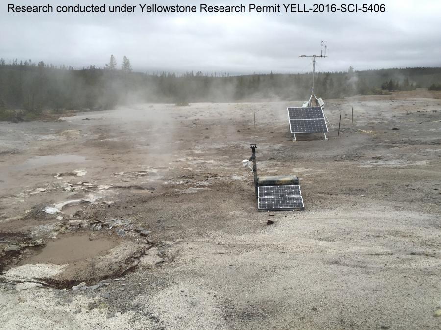
Eddy covariance and mutigas instruments temporarily deployed to measure thermal and gas emissions near the Norris Geyser Basin in 2016 (the sensors were installed in May and removed in October).
The Norris Geyser Basin is host to an array of temperature sensors that monitor changes in the flow of hot water out of the ground. These data can be accessed on YVO’s monitoring webpage (zoom in to the Norris area and click on any of the thermometer icons to see plots of temperature at those stations over time). YVO also measures water chemistry of samples taken from hot springs and geysers to track their origins and underground flow paths, and heat flow is tracked by thermal infrared instruments on both aircraft and satellites. Many of these datasets are described in USGS data releases or publications about gas and water samples, gas and thermal samples from a 2016 temporary experiment, and satellite and ground-based thermal mapping. In the summer of 2018, new instruments are planned for continuous measurement of heat and gas emissions from Norris Geyser Basin.
Together, the array of information obtained from this diverse monitoring toolset should shed light on the potential causes of hydrothermal variations in Norris Geyser Basin and mitigate related hazards in the future.
Source : YVO.
Photos : Jennifer Lewicki ( 27/06/2017 , 03/10/2016 )