January 13 , 2026.
Hawaii , Kilauea :
HAWAIIAN VOLCANO OBSERVATORY DAILY UPDATE ; U.S. Geological Survey
Monday, January 12, 2026, 9:50 AM HST (Monday, January 12, 2026, 19:50 UTC)
19°25’16 » N 155°17’13 » W,
Summit Elevation 4091 ft (1247 m)
Current Volcano Alert Level: WATCH
Current Aviation Color Code: ORANGE
Activity Summary:
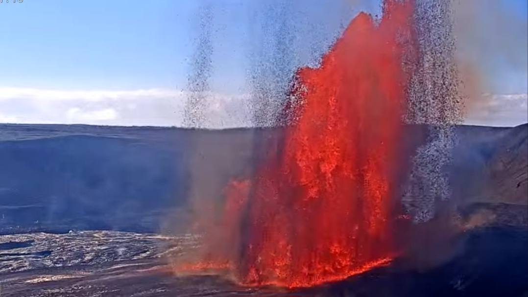
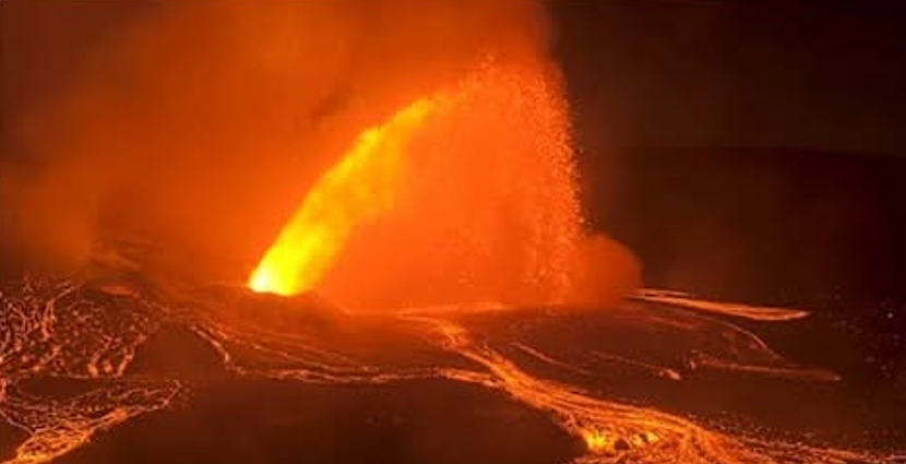
Episode 40 sustained lava fountaining at the summit of Kīlauea began at 8:22 a.m. HST on January 12. Sustained lava fountains erupting from the north vent are currently reaching heights of more than 660 feet (200 meters) and feeding a lava flow on the crater floor. Intermittent spatter continues from the south vent. Tephra is currently falling on the western and southern rim of Halema’uma’u crater. Volcanic gas emission rates increased significantly with the onset of sustained lava fountaining. The sulfur dioxide emission rate is typically 50,000-100,000 tonnes/day during an eruptive episode. The gas plume is currently rising straight up to heights over 13,000 feet (4,000 m) above ground level. Ground-level sensors near the eruptive vents indicate that winds are light at the summit, less than 5 mph (2 m/s), and variable in direction. This makes it difficult to predict how the eruption plume will spread during this episode, but it will probably remain closer to Halemaʻumaʻu and the summit. Kīlauea’s East Rift Zone and Southwest Rift Zone remain quiet.
Summit Observations:
Episode 40 sustained lava fountaining began at 8:22 a.m. HST on January 12 as indicated by strong deflation and increaseed tremor after north vent fountains increased dramatically in height and vigor at 8:13 a.m. Sustained fountaining was preceeded by several days of significant precursory activity that included cyclic spatter and dome fountains from both the north and south vents that fed large lava flows on the crater floor including a flow from the south vent that reached 3,300 feet (1,000 meters) in length.
North vent fountains are currently feeding lava flows on the floor of Halema’uma’u crater. At about 6:30 a.m. this morning, spattering in the north vent increased and began to feed an overflow from the vent. At about 7:00 a.m., the spattering transitioned to a continuous narrow and small fountain, likely caused by a restriction in the vent that resuled in a nozzle-effect that led an arcurate spatter fountain 15-30 feet (5-10 meters) high feeding a flow from the north vent. Sustained fountaining from the north vent began at 8:22 a.m. Fountain heights increased steadily and currently exceed 660 feet (200 meters) in height. Right now, the tephra fall out zone is observed to be on the western and southourn rim of Halema’uma’u crater.
Sustained lava fountains are not yet erupting from the south vent at the time of this update but intermittent lava spattering and small dome fountains continue. The south vent formed dome fountains feeding overflows from the vent at a rate of about one per hour over the past day, with about 30 overflows total feeding lava flows on the floor of Halemaʻumaʻu crater.
UWD returned to inflation after 9 a.m. yesterday morning, with nearly a microradian of inflation since then, returning to 22.8 microradians. The Uēkahuna tiltmeter (UWD) had previously reached 23 microradians of re-inflation of Kīlauea’s summit on Saturday January 10. This peak was followed by a brief deflationary period dropping to 22 microradians associated with the onset of precursory overflows from the north and south vents the night January 10. The SMC tiltmeter mirrors the UWD tiltmeter, but SDH shows continued slight inflation, possibly influenced by the deeper south caldera magma chamber.
Volcanic gas emission rates increased significantly with the onset of sustained lava fountaining. The sulfur dioxide emission rate is typically 50,000-100,000 tonnes/day during an eruptive episode. The gas plume is currently rising straight up to heights over 13,000 feet (4,000 m) above ground level.
Rift Zone Observations:
Rates of seismicity and ground deformation remain very low in the East Rift Zone and Southwest Rift Zone. SO2 emissions from the East Rift Zone remain below the detection limit.
Issued: Monday, January 12, 2026, 6:13 PM HST
Volcanic Activity Summary:
Episode 40 of the ongoing Halemaʻumaʻu eruption ended abruptly at 6:04 p.m. HST on January 12 after 9.7 hours of continuous lava fountaining. Additional details on this eruptive episode will be provided in the next official report.
Source et photos : HVO
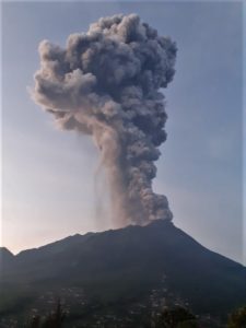
Indonesia , Semeru :
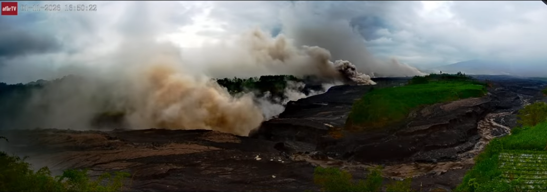
Mount Semeru erupted Sunday evening (January 12), sending pyroclastic flows—locally known as « hot clouds »—up to five kilometers from the summit.
« Mount Semeru erupted at 10:25 p.m. local time. The eruption consisted of a pyroclastic flow approximately 5 kilometers long, » said Sigit Rian Alfian, an official at the Mount Semeru observation post, in a written report.
The eruptive column was observed about 2,000 meters above the summit, at an altitude of 5,676 meters.
This latest activity follows a period of heightened unrest for the volcano, which has been frequently active in recent years.
« The ash column was white to gray in color, with a high intensity, and directed east and southeast, » Alfian added. The eruption of Mount Semeru was recorded by seismographs with a maximum amplitude of 27 mm and a duration of 696 seconds.
Mount Semeru remains on alert level III. Authorities are advising the public to refrain from all activity in the southeast sector, along the Besuk Kobokan River, within a 13-kilometer radius of the summit.
Beyond this distance, all activity is prohibited within 500 meters of the Besuk Kobokan River banks due to the risk of pyroclastic flows and lahars expanding, which could extend up to 17 kilometers from the summit. « The public is advised to stay away from the crater/summit of Mount Semeru due to the risk of ejected incandescent rocks, » they added.
Residents are also warned of the risks of pyroclastic flows and lahar flows descending the rivers and valleys that originate at the summit of Mount Semeru, particularly in Besuk Kobokan, Besuk Bang, Besuk Kembar and Besuk Sat, including the small tributaries of Besuk Kobokan which could also be affected by lahars.
Sources : Antaranews.com.
Photo : Afar tv .
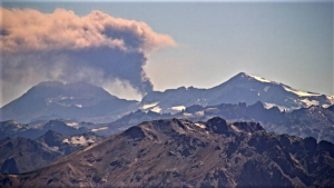
Italy / Sicily , Etna :
Etna Activity Update, January 12, 2026, 7:04 PM (6:04 PM UTC).
The National Institute of Geophysics and Volcanology, Etna Observatory (INGV-OE), reports that in recent days, following the publication of the bulletin of January 9, 2026, cloud cover has frequently obscured the observation of eruptive activity. However, faint glows have been observed occasionally at the effusive vents in the upper Valle del Bove, as well as fluctuating glows at the vent that opened on the eastern flank of the Voragine crater on December 27, 2025. No active lava flows have been observed near the effusive vents; an inspection will be carried out tomorrow by INGV-OE personnel.
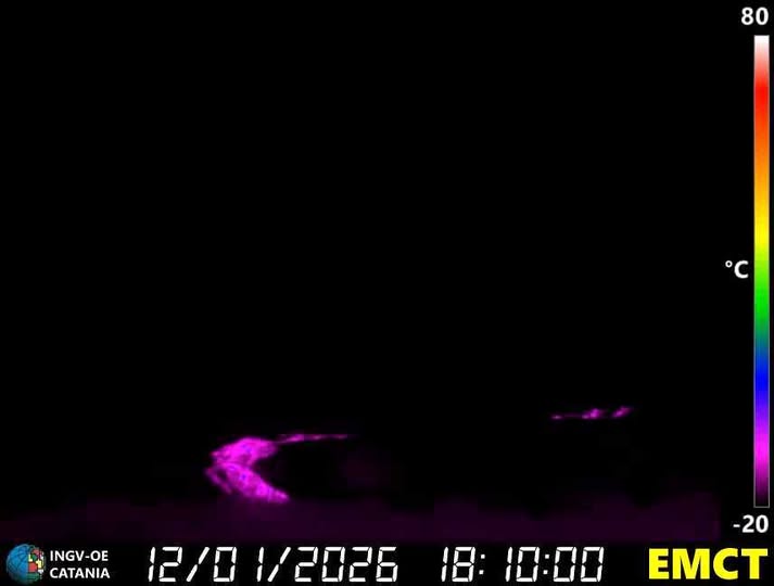
From a seismic perspective, the average amplitude of volcanic tremor continues to fluctuate between moderate and low values. The center of the volcanic tremor sources is located slightly northwest of the Northeast Crater, at an altitude of approximately 2.4 km.
Infrasound activity remains low, and the few recorded events are located near the Bocca Nuova (BN) Crater.
Ground deformation monitoring networks show no significant changes.
Further information will be released soon.
Source et photo : INGV.
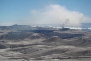
Peru , Sabancaya :
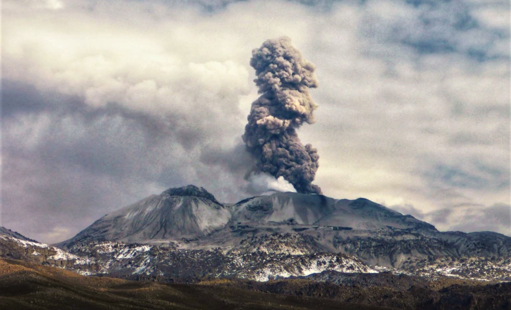
Local date and time: January 12, 2026 – 11:26 AM
Bulletin analysis period: January 5-11, 2026
Volcanic alert level
Orange alert level: The volcano’s eruptive activity has increased significantly. Increased seismic activity, frequent explosions, and emissions of ash and ballistic fragments have been observed.
Conclusions
During this period, two moderate volcanic explosions were detected, generating columns of ash and gas up to 2,100 m above the volcano’s summit, in addition to seismic activity associated with the movement of magmatic fluids and internal fracturing. Therefore, the volcanic alert level remains orange.
Recommendations
Adopt preventive measures in accordance with the current orange volcanic alert level.
Do not approach within 12 km of the crater. In case of ashfall, cover your nose and mouth with damp cloths or a mask. Keep doors and windows closed.
Outlook
Future volcanic explosions generating eruptive columns more than 2 km high are considered likely and could affect districts in the Colca Valley and surrounding areas through the dispersal of volcanic ash. Therefore, the volcanic alert level remains orange.
Source : Cenvul
Photo : Andina .
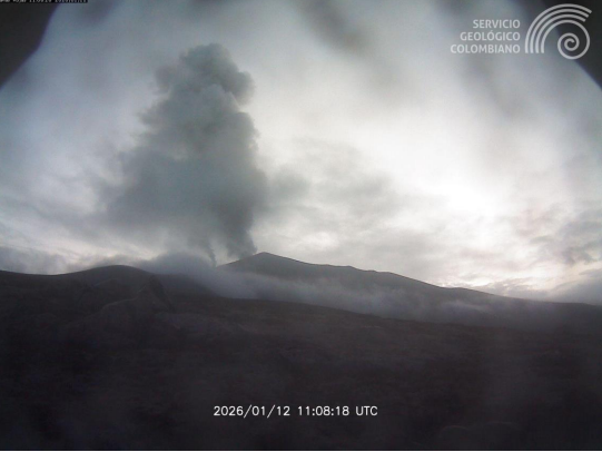
Colombia , Puracé – Los Coconucos volcanic chain :
Popayán, January 12, 2026, 9:00 AM
Regarding the monitoring of activity in the Los Coconucos volcanic chain, the Geological Survey of Colombia (SGC), an agency under the Ministry of Mines and Energy, reports the following:
Since the publication of yesterday’s extraordinary bulletin and continuing to this day, earthquakes related to fluid circulation within the volcanic edifice have continued to occur. These are long-period (LP) tremor (TR) earthquakes. These earthquakes, located below the crater of the Puracé volcano at a depth of less than 1 km, are linked to circulation processes and the release of volcanic gases into the atmosphere. Among these seismic signals, two (2) were associated with ash emissions dispersed to the northeast, following the wind direction, reaching a maximum altitude of 1,600 m above the summit of the volcano. Furthermore, low-magnitude seismic activity, associated with rock fracturing, continued to be recorded. These earthquakes were located beneath the Piocollo volcano, at a depth of 1 km, and beneath the northeast flank of the Puracé volcano, at a depth of 2 to 3 km.
Sulfur dioxide (SO₂) emissions continue to be recorded, and gases continue to escape from fissures in the craters of the Curiquinga and Piocollo volcanoes, although no ash emissions have been identified to date. Satellite measurements indicate that the temperature inside the Puracé volcano crater, linked to the volcanic gas emissions, has decreased.
As long as the orange alert level remains in effect, temporary fluctuations in volcanic activity are possible, meaning it may sometimes decrease compared to previous days or weeks. However, this does not necessarily mean the volcano has returned to a stable level of activity. A reasonable amount of time is needed to return to the yellow alert level (increased stability) to assess all monitored parameters and determine any trends indicating such a return.
Given the above, the Geological Survey of Colombia (SGC) recommends staying away from the craters of the Puracé, Piocollo, and Curiquinga volcanoes, as well as their surrounding areas. We suggest closely monitoring the situation through special bulletins and information disseminated through our official channels, and following the instructions of local and departmental authorities and the National Unit for Disaster Risk Management (UNGRD).
The volcanic activity alert level remains orange: Volcano exhibiting significant variations in monitored parameters.
Source et photo : SGC.