January 12 , 2026.
Hawaii , Kilauea :
HAWAIIAN VOLCANO OBSERVATORY DAILY UPDATE, U.S. Geological Survey
Sunday, January 11, 2026, 9:23 AM HST (Sunday, January 11, 2026, 19:23 UTC)
19°25’16 » N 155°17’13 » W,
Summit Elevation 4091 ft (1247 m)
Current Volcano Alert Level: WATCH
Current Aviation Color Code: ORANGE
Activity Summary:
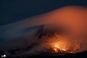
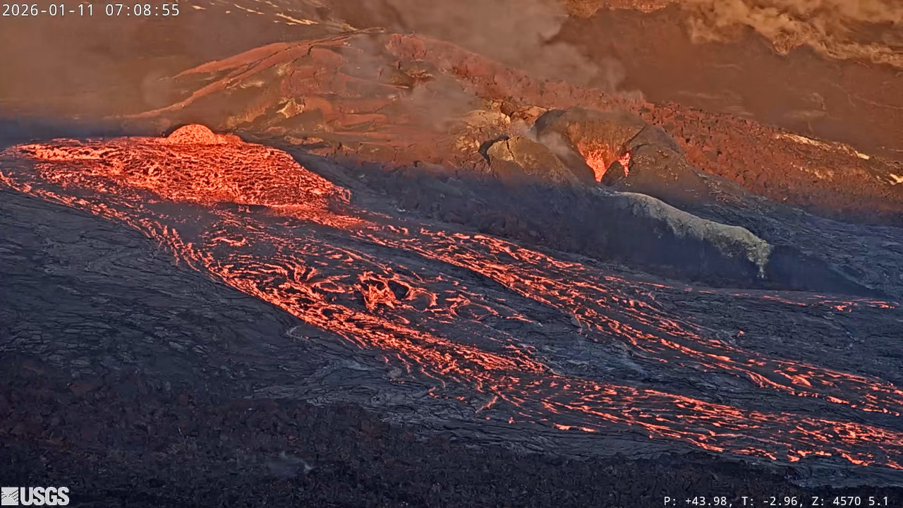
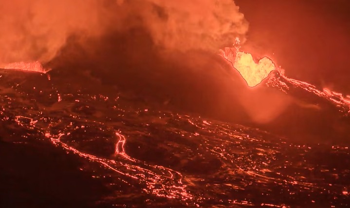
Lava overflowed nearly continuously from the north vent in Halemaʻumaʻu overnight, with continued pulses of dome fountaining and overflows from the south vent. Activity has decreased this morning to about one overflow per hour from the south vent and only spattering from the south vent.Kīlauea summit region showed deflation on tiltmeter UWD since about 4 p.m. yesterday. The prolonged precursory activity has extended the forecast window for the onset of episode 40 high foutaining from now to January 17. Kīlauea’s East Rift Zone and Southwest Rift Zone remain quiet.
A VAN/VONA notice will be issued at the onset of episode 40 sustained lava fountaining.
Summit Observations:
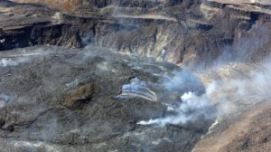
Nearly continuous overflows continued from the north vent most of yesterday and throughout most of last night. Intermittent dome fountains continued to form within the south vent over the past day and last night, feeding pulses of lava overflowing from the south vent several times an hour. Activity at the north vent decreased after 3 a.m. this morning, with lava only intermittently overflowing the vent. As of this morning, only spattering is visible within the north vent and large overflows from the south vent have slowed to about one per hour with the last overflow ending just before 9:10 a.m. HST. Overflows from the south vent continue to feed an active lava flow that extends over 1500 feet (500 meters) across the floor of Halemaʻumaʻu crater.
Since the end of episode 39, the Uēkahuna tiltmeter (UWD) has recorded 23 microradians of re-inflation beneath Kīlauea summit; however, UWD showed nearly a microradian of deflation to 22 microradians since about 4 p.m. yesterday associated with the overflows from the north and south vents last night. The SMC tiltmeter mirrors the UWD tiltmeter, but SDH shows continued slight inflation, possibly influenced by the deeper south caldera magma chamber.
Volcanic gas emission rates have dropped significantly since the end of episode 39 but probably remain in the range of 1,000 to 5,000 tonnes of sulfur dioxide (SO2) per day, as typically observed during previous eruptive pauses. Winds are light out of the north (less than 10 mph or 2 m/sec) and are forecast to become more southerly in the afternoon. The plume is moving to the south-southwest of Halema’uma’u.
Rift Zone Observations:
Rates of seismicity and ground deformation remain very low in the East Rift Zone and Southwest Rift Zone. SO2 emissions from the East Rift Zone remain below the detection limit.
Analysis:
The rapid rebound of inflationary tilt and presence of low-level volcanic tremor after episode 39 indicate that another lava fountaining episode is likely to occur. Nearly continuous overflows of the north vent overnight coupled with overflows from both vents this morning suggested the onset of episode 40 could be close; however, slow deflation of the summit region since 4 p.m. yesterday, along with decreased activity at the vents since this morning suggest that the onset of episode 40 fountaining could be delayed as a result of the prolonged precursory eruptive activity over the past several days. Forecast models suggest the window for onset of episode 40 fountaining has been extended from now through January 17. Precursory activity could continue through then, with low dome fountains and spattering with the north and south vents feeding lava flows onto Halemaʻumaʻu crater floor.
Source et photos : USGS
Indonesia , Kelimutu :
A landslide occurred on the rim of Crater II (Tiwu Koofai Nuwamuri) on Mount Kelimutu, Ende Regency, East Nusa Tenggara Province, on January 12, 2026.
Based on videos taken by visitors showing waves on the surface of Crater II (Tiwu Koofai Nuwamuri) and on-site inspections, this incident was caused by a partial landslide on the northeast rim of the crater. This landslide was likely triggered by heavy rainfall that destabilized the rim.
Visual and instrumental observations conducted up to January 12, 2026, revealed no significant increase in seismic activity, color, or temperature of the crater.
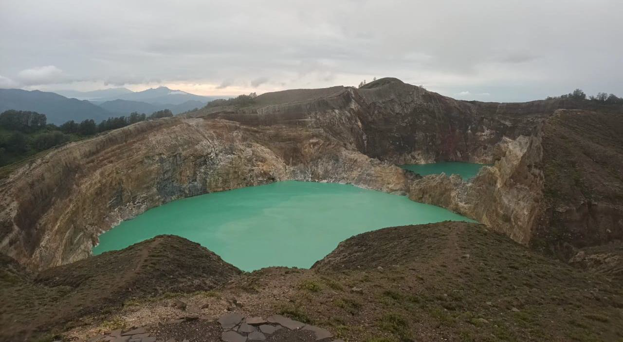
Mount Kelimutu is a stratovolcano with a summit reaching 1,384.5 meters (3,000 feet) above sea level. Geographically, Mount Kelimutu is located at coordinates 08°45’30”S and 121°50’00”E. Administratively, it lies within the Ende Regency, East Nusa Tenggara Province. Mount Kelimutu has three crater lakes: Crater I (Tiwu Ata Polo), Crater II (Tiwu Koofai Nuwamuri), and Crater III (Tiwu Ata Bupu).
Currently, Mount Kelimutu is at Volcanic Activity Level I (NORMAL). It is a popular tourist destination, attracting a significant number of visitors. In view of all this data, residents in the vicinity of Mount Kelimutu and visitors are advised to limit their activities around the crater by staying inside the perimeter fence, avoiding approaching the crater lake, avoiding gas leaks and avoiding spending the night inside the crater in order to avoid potential risks related to toxic gases.
Source et photo : PVMBG.
Colombia , Puracé – Los Coconucos volcanic chain :
Popayán, January 11, 2026, 9:00 AM
Regarding the monitoring of activity in the Los Coconucos volcanic chain, the Colombian Geological Survey (SGC), an agency under the Ministry of Mines and Energy, reports the following:
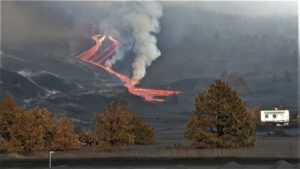
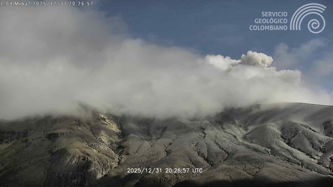
Since the publication of yesterday’s extraordinary bulletin and continuing to this day, earthquakes associated with fluid circulation within the volcanic edifice have continued to occur. These are long-period (LP) tremor (TR) earthquakes. These earthquakes were located beneath the crater of the Puracé volcano, at depths of less than 1 km, and were linked to circulation processes and the release of volcanic gases into the atmosphere. Among these seismic signals, one (1) was associated with an ash emission which dispersed mainly towards the Northwest, following the direction of the wind, reaching altitudes of over 800 m above the summit of the volcano.
In addition, low-magnitude seismic activity, associated with rock fracturing, continued to be recorded. These earthquakes were primarily located beneath the Piocollo volcano, at depths between 1 and 3 km.
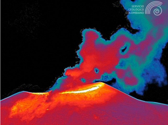
Sulfur dioxide (SO₂) emissions and areas of higher temperatures continue to be recorded in the Puracé volcano crater, linked to the release of high-temperature gases from within the volcano. Gas emissions also persist through fissures in the Curiquinga and Piocollo volcano craters, although no ash emissions have been identified to date. As long as the orange alert level remains in effect, temporary fluctuations in volcanic activity are possible, meaning that it may sometimes decrease compared to previous days or weeks. However, this does not necessarily imply that the volcano has returned to a stable level of activity. Returning to the yellow alert level (greater stability) requires a reasonable timeframe to assess all monitored parameters and identify trends indicating a resumption of activity.
Recording from the Mina camera, located 2.2 km north of the Puracé volcano, showing an ash emission that occurred on January 11, 2026, at 1:22 a.m. (local time).
Given the above, the Geological Survey of Colombia (SGC) recommends staying away from the craters of the Puracé, Piocollo, and Curiquinga volcanoes, as well as their surrounding areas. We suggest closely monitoring the situation through special bulletins and information published on our official channels, as well as instructions from local and departmental authorities and the National Unit for Disaster Risk Management (UNGRD).
The volcanic activity level remains at orange alert: Volcano with significant variations in monitored parameters.
Source et photo : SGC
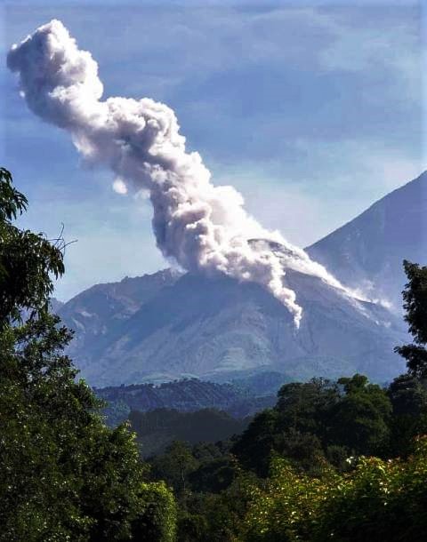
Ecuador , El Reventador :
REVENTADOR VOLCANO DAILY STATE REPORT, Sunday, January 11, 2026.
Information Geophysical Institute – EPN.
Surface Activity Level: High, Surface Trend: No Change
Internal Activity Level: Moderate, Internal Trend: No Change
From January 10, 2026, 11:00 AM to January 11, 2026, 11:00 AM:
Seismicity:
The table below shows the number of seismic events recorded at the reference station:
Explosion (EXP) 63
Long Period (LP) 7
Emission Tremor (TREMI) 4
Harmonic Tremor (TRARM) 6
Rainfall / Lahars:
No precipitation was recorded in the volcano area. **In the event of heavy rain, this could remobilize the accumulated materials, generating mud and debris flows that would cascade down the volcano’s slopes and flow into nearby rivers.**
Emission Column/Ash:
Due to poor weather conditions, it was not possible to observe gas and ash emissions via the surveillance camera system. However, satellite imagery detected three gas and ash emissions, with plumes reaching heights between 800 and 1,000 meters above the crater rim, drifting west and west-northwest.
Related to this activity, the Washington VAAC issued three reports of emissions, with plumes reaching altitudes of 700 to 1,000 meters above the crater rim, drifting west and west-southwest.
Gas:
The Mounts satellite system detected 7.4 tons of SO₂ (sulfur dioxide), measured yesterday at 2:18 p.m. local time.
Other monitoring parameters:
Over the past 24 hours, the FIRMS and MIROVA-MODIS satellite systems each recorded a thermal anomaly.
Observation:
From yesterday afternoon until the publication of this report, the volcano remained completely obscured by clouds.
Alert level – SGR: Orange
Source et photo : IGEPN.
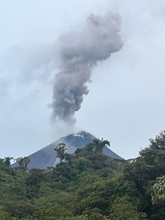
Guatemala , Santiaguito :
Atmospheric conditions: Clear skies
Wind: Northeast
Rainfall: 0 mm
Activity
The Santiaguito Volcanological Observatory reports favorable conditions for observing the dome.
Weak white degassing fumaroles are observed 250 meters above the Caliente dome, along with weak to moderate explosions, occurring at a rate of 1 to 2 per hour, projecting columns of gas and ash up to 800 meters in altitude.
These columns are drifting southwest under the influence of the wind. Incandescence may be visible on the dome, as well as the detachment of incandescent rock blocks to the west, southwest, and south. Light ashfall is possible on Loma Linda, San Marcos Palajunoj, and surrounding areas, due to the wind direction. Because of the significant accumulation of rock material, the Caliente dome and the promontory overlooking the lava flow could collapse and generate long-range pyroclastic flows to the southwest, south, southeast, and northeast. Therefore, the recommendations of Special Bulletin BESAN-063-2025 must be followed.
Source : Insivumeh.
Photo : Conred.