November 26 , 2021.
Ecuador , Sangay :
Update on the internal and surface activity of the Sangay volcano
Abstract
Since May 6, 2019, the Sangay volcano has exhibited an eruptive activity cataloged as moderate to high, with almost continuous emissions of gas, ash, lava flows, pyroclastic flows and lahars. In recent weeks, the parameters of the internal activity of the volcano have shown an increase in the number of small explosions, as well as a slight inflationary trend on all sides of the volcano. On the other hand, the surface parameters show a continuous emission of lava flows (constant thermal anomalies) and slight changes in the morphology of the volcano. This type of activity is very common on the Sangay volcano, which maintains its internal and surface activity at levels considered high at the time of this report.
Since July 2021, Strombolian activity has started to dominate, which is confirmed by occasional visual sightings on sunny days.
Since 8:00 p.m. TL (local time) on November 17, there has been an increase in the number of explosions on the Sangay volcano, reaching an average of 2 per minute. The vast majority of these explosions are small, as evidenced by both the seismic signal (Fig. 3), which in some cases does not exceed the sound level of the station, and the acoustic signals of the explosions (less than 10 Pascals). This activity persists until the early hours of November 23.
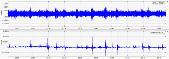
Graph 3. Seismic recording of November 17 with 20 minutes duration of the infrasound sensor of the SAGA station, located about 6 km from the crater of the volcano. You can see 20 pulses that exceed 2000 units.
Deformation
For the deformation analysis, Synthetic Aperture Radar (InSAR) image processing of the Sentinel-1 satellite of the European Space Agency (ESA) was performed using ISCE and Mintpy software. Figure 4 is a speed map from January 5, 2020 to November 13, 2021, using the SBAS (Small Baseline) method.
Data analysis and interpretation
In the period of time studied in the satellite line of sight (LOS), the zones represented in yellow – orange – red (Fig. 4) record the movements of the southwest, north and northwest flanks of the volcano at a speed of up to 5 cm / year. The displacement is considered a positive deformation or swelling, which is observed around the volcano, on the average flanks of the building in the Southwest, North and East areas.
While in the outer part of the building (celestial colors – green) they present an area with very little deformation, with a negative tendency or deflation at deformation rates between 0 and -5 cm / year in the period of time . The area that records the greatest negative deformation is located to the northeast (blue point), outside the volcanic building.
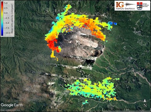
Fig. 4.: Deformation rate map obtained by InSAR, based on Sentinel-1 images of the descending orbit of the Sangay volcano, between January 5, 2020 and November 13, 2021.
Morphological changes in the southeast ravine of the Sangay volcano
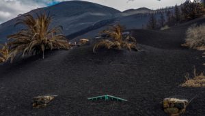
During the current eruptive period of the Sangay volcano (May 2019 – present), morphological changes have been evident. The main change is associated with the continuous erosion of the south-eastern flank, which has given rise to the formation of a large ravine through which is channeled the pyroclastic material emitted by the volcano (i.e. lava and pyroclastic currents). During the last overflight in June 2020 (Fig. 10), the maximum width of this ravine was quantified at around 390 ± 10 meters.
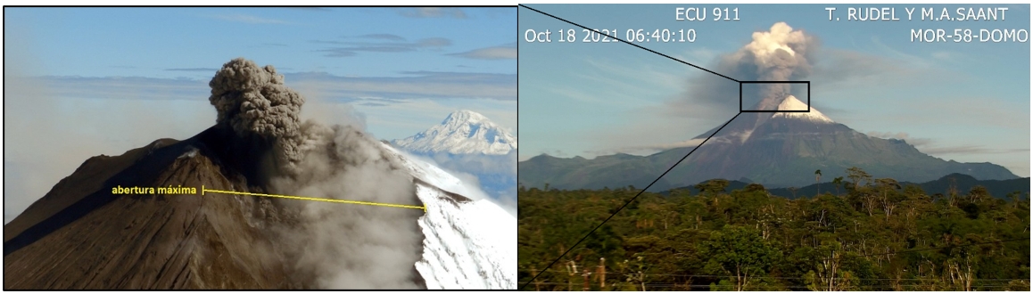
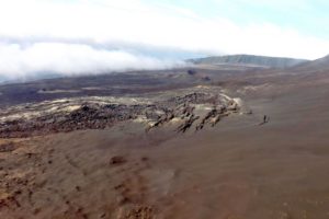
Figure 10. Left: photo taken during the flyover on June 24, 2020. In yellow we see the southeast ravine and its maximum opening at the top. In addition, a small explosion can be observed, very characteristic of the continuous activity of the volcano since May 2019. Right: photo taken by ECU911 on October 18, 2021.
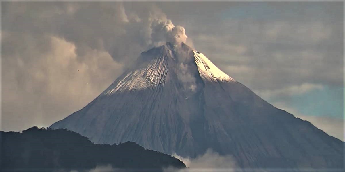
According to satellite images, it was possible to quantify the growth of the ravine. The last satellite image obtained corresponds to October 13, 2021 (Fig. 11). In this, we observe that the erosion continues, but it is not as aggressive as in the period from August 2019 to March 2020. In addition, the processing of the X band of the Terrasar satellite, made it possible to quantify the The maximum opening of the ravine in October 2021 with a value of 650 ± 50 m, which compared to March 2021 (600 ± 40 m) remained relatively stable. These morphological changes depend on the activity levels of the volcano (for example, the rate of emission of volcanic material), as well as other external erosive agents (for example, rain, wind and the action of gravity on it. -same). Currently, erosion in the Southeast Ravine is less, and on the contrary, it seems to be starting to fill with the material that is currently being emitted non-explosively and slowly since July of this year.
Most likely scenario: Eruptive activity continues, with possible paroxysms, light or heavy ash emissions and potential remobilization of debris in the Southeast Ravine.
The eruptive activity could continue to alternate phases of higher eruptive activity (emissions of ash columns of more than 2 km in height) and phases of lower activity (ash columns of less than 2 km in height). ). This scenario involves the continuous or sporadic emission of lava flows, mainly in the Southeast Ravine, with the subsequent collapses of the lava front, which, in turn, produce pyroclastic flows that descend through the sources of the river. Volcano (very few reach the confluence with the Upano river).
In this scenario, the main phenomena that can affect the population are: (1) light to heavy ash fall due to explosive activity, and the remobilization of previously deposited material. The transport of ash clouds is directed by the direction and speed of the wind, which is generally directed west and northwest, with possible variations north and southeast of the volcano. (2) the generation of debris flows (lahars) in the Volcán and Upano rivers, associated with the removal of volcanic material deposited by the effect of heavy rains, typical of this region. Based on the data available to us to date, this scenario is the most likely in the short term and represents the typical activity of at least the last 100 years of activity of the Sangay volcano.
Source : IGEPN.
Read the full article : https://www.igepn.edu.ec/servicios/noticias/1902-informe-volcanico-especial-sangay-2021-n-002
Photos : IGEPN , ecu911.
Spain / La Palma , Cumbre Vieja :
November 25, 2021 09:00 UTC. Eruptive activity continues on La Palma.
Since the last declaration, a total of 26 earthquakes have been located in the volcanic reactivation in the Cumbre Vieja region, of which 4 were felt by the population.
The maximum recorded magnitude is 3.9 (mbLg) corresponding to today’s earthquake at 7:53 UTC, with a depth of 11 km and intensity IV (EMS92).
In the period considered, 7 earthquakes were located at a depth of about 30 km, the rest of the hypocenters of the period are located at a shallower depth, around 12 km.
The amplitude of the volcanic tremor signal continues at lower average levels.
The network of permanent GNSS stations on the island does not show a clear trend in the deformation of the stations closest to the eruptive centers.
In the rest of the stations, the slight deflation possibly linked to the deep seismicity has stabilized, except in LP01 which continues to record it.
Yesterday at 12:50 UTC, due to the increase in the height of the eruptive column, the IGN issued a new VONA (Volcano Observatory Notice for Aviation) message communicating that said height was 4800 m above the level of the sea.
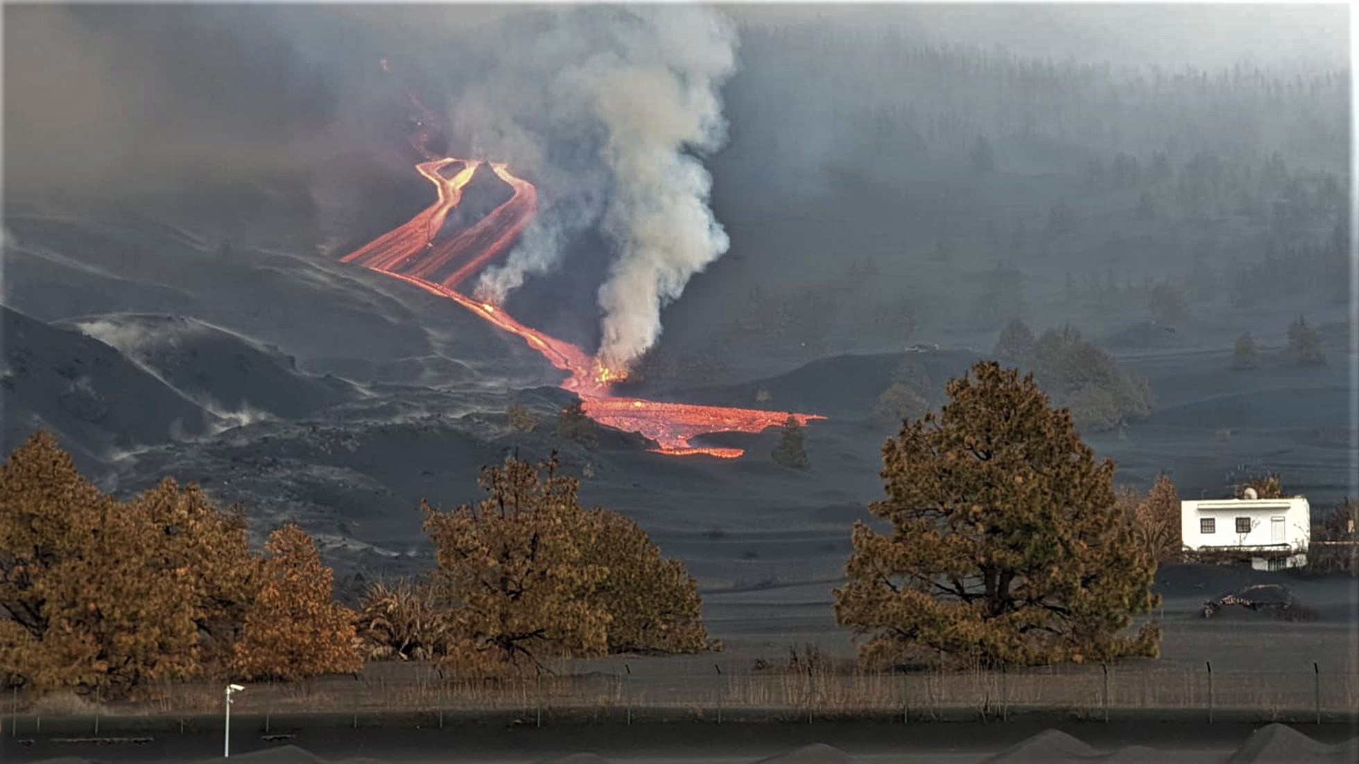
The volcano of La Palma recorded a rebound in activity on Thursday after several days of « energy loss », according to the definition of volcanologists at the National Geographic Institute. The volcanic cone added at least four overflows during the early hours of Thursday, which increased the flow rate. « This is a specific fact that occurs in all eruptive processes, » National Geographic Institute (IGN) volcanologist Rubén López explained on his Twitter account. IGN sources reported that they were studying the opening of a new emission point and verified the creation of a new lava flow, probably on the Southern Front.

A new lava outlet opened south of the main cone of La Palma volcano early Thursday evening, as reported by the Canary Islands Volcanological Institute (Involcan). Throughout the day, the eruption saw an increase in activity after several days of « loss of energy. » The volcanic cone added at least four overflows between the early hours of Thursday and the early hours of Friday, which increased the flow rate. As a result, a new lava tongue has formed which crosses new territory and which worries technicians because these are urbanized areas. This new flow has already covered the cemetery of Las Manchas. The heavy rains that fell in the east of the island in the early hours of Thursday led the State Meteorological Agency (Aemet) to issue a yellow warning which will be extended to the rest of the island during this Friday. , and constitutes an additional complication in the fight against the consequences caused by the eruption of the volcano.
Carmen López, head of volcanic monitoring at the National Geographic Institute, confirmed the formation of a new lava flow. “There is an increase in the emission rate with lava channel branches and overflows affecting the same area as yesterday, surrounding the northeast area of Todoque Mountain. At around 9:00 a.m., an episode of sudden increase in lava emission was observed at the main effusive emission point above the volcanic cone. At around 11:00 am, in some of the more easterly emission points, there was the emission of a new lava flow that spreads southwest to cover new territory, ”López said.

The ash cloud is expected to remain the same until Saturday, when easterly winds will be a favorable scenario for the operation of the airport. Seismicity continues at intermediate depths at low levels. That at depths greater than 20 kilometers has decreased. The biggest earthquake of the last day was of magnitude 3.9 at 7:53 am 11 kilometers deep.
Source : IGN es , El Pais .
Photos : IGN , Felixcapotes.
Vidéo : Involcan .
Carte : Volcanes y Ciencia Hoy
Italy , Stromboli :
PRESS RELEASE ON THE ACTIVITY OF STROMBOLI, November 25, 2021, 09:33 (08:33 UTC).
The National Institute of Geophysics and Volcanology, Osservatorio Etneo, announces that the monitoring networks recorded a variation in the monitored parameters at 09:32 (08:32 UTC).
In particular, a thermal anomaly is observed from the surveillance cameras.
25 November 2021, 09:58 (08:58 UTC).
The National Institute of Geophysics and Volcanology, Osservatorio Etneo, announces that from ~ 07: 00 UTC from surveillance cameras a modest lava overflow is observed from the northern area of the terrace of the Stromboli crater which remains for the moment confined to the summit, at an altitude of about 750 meters above sea level. The front of the lava flow causes the rolling of materials along the Sciara del Fuoco. There are no specific variations regarding explosive activity.
From a seismic point of view, there are no particular variations compared to the last 24 hours.
Inclinometer and GPS stations do not record significant changes.

12:40 (11:40 UTC): Through the analysis of the data recorded by the surveillance cameras, it is observed that the lava overflow continues from the northern area of the terrace of the Stromboli crater. For now, the lava flow remains limited in the upper part of the Sciara del Fuoco and the lava blocks break off from the front and roll along the Sciara del Fuoco to the coast. Ordinary Strombolian activity persists in the North and Center-South crater areas.
From the seismic point of view, the volcanic tremor remains at average levels with weak oscillations.
Regarding the deformations of the ground during the last hours, no significant change in the signals was evidenced.

20:43 (19:43 UTC): From surveillance cameras, it is observed that the overflow of lava from the northern area of the terrace of the Stromboli crater still seems to be fed. The front of the lava flow, which is in the upper part of the Sciara del Fuoco, breaks and causes the rolling of boulders along the Sciara del Fuoco. Finally, an ordinary Strombolian activity persists both in the areas of the North and Center-South crater; from the start of the overflow phenomenon there was a decrease in the intensity and frequency of the explosions compared to what was observed during the week.
The volcanic tremor did not show significant changes while maintaining the amplitude values in the mean.
There are no significant changes in tilt and GPS signals
Further updates will be communicated shortly.
Source : INGV.
Photos : INGV , Rosaria Cincotta (archive).
Iceland , Grímsvötn :
Icesheet in Grímsvötn subsiding. 24.11.2021
Updated 24.11 at 16:30
The Scientific Advisory Board for the Civil Defense met today to discuss changes measured at Grímsvötn. GPS measurements are showing that the icesheet has started subsiding which indicates that a flood from Grímsvötn is likely starting.
The icesheet has now subsided about 60 cm in the last few days and the speed of subsidence has increased in the past 24 hours. These measurements indicate that it is most likely that water has started to leave from Grímsvötn lake and that Gígjukvísl will flood.
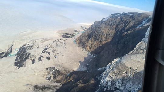
Based on observations of past floods, it is anticipated that flood water will be exiting the glacier edge in the next 48 hours and the flood will peak 4-8 days after that. At this moment no increase in electrical conductivity has been measured in Gígjukvísl which is the clearest sign that Grímsvötn flood waters have exited from under the glacier. IMO also has gas monitors along Gígjukvísl which will indicate if flood water has reached those points in the river.
The maximum discharge anticipated from this flood is calculated to be around 5000 m3/s. This size of flood will most likley not affect the infastructure in the area such as roads or bridges. These forecasts are uncertain at this early stage.
There are past examples of Grímsvötn eruptions starting following a flood. The loss of the water from Grímsvötn lake reduces the pressure on top of the volcano and this can allow an eruption to begin. This happened in 2004, and before that in 1934 and in 1922. In 2004 the eruption started three days after the first observations were made of flood onset. There were a series of earthquakes in the days preceeding the eruption. No such earthquakes have been measured at this point in time.
Updated 25.11 at 9:15
The icescheet has continued to subside evenly throughout the night. IMO´s GPS instruments show that is has sunk about 25 cm since 10:00 yesterday. There are no signs of increased water level, electrical conductivity or gas in Gígjukvísl at this time.
IMO continues to monitor Grímsvötn closely and will keep updating this news as things develop.
Source : Vedur is
Photo : IMO.
Dominica , Boiling Lake :
Observations made by a team of UWI-SRC scientists accompanied by staff of Forestry, Wildlife & Parks Division, and local volunteer volcanologist with the ODM on a field trip to Boiling Lake, Dominica on 22/11/21 indicate that water levels have increased since a decline in activity was reported on 18 November. The Lake is now approximately 2m below its normal level. Water temperatures are within the normal range at ~ 87°C.
There was a small, fresh landslide observed near the outlet of the Lake. Based on scientific knowledge of how the Lake behaves, these fluctuations occur when there vents beneath the lake are blocked. This limits the flow of gas and water into the Lake and when vents are unblocked the flow resumes. Water levels may therefore fluctuate before returning to normal.

During these episodes harmful gases such as Carbon Dioxide, can be released and small steam explosions may also occur. People should, therefore, avoid visiting the immediate area at the Boiling Lake until the activity has subsided.
The UWI-SRC and Dominica’s Office of Disaster Management (ODM) with support from the Forestry, Wildlife & Parks Division, are continuing to monitor the situation and will provide updates.
Source : UWI / Centre de recherche sismique .
Photo : UWI / ODM