December 9 , 2025.
Hawaii , Kilauea :
HAWAIIAN VOLCANO OBSERVATORY DAILY UPDATE , U.S. Geological Survey
Monday, December 8, 2025, 8:56 AM HST (Monday, December 8, 2025, 18:56 UTC)
19°25’16 » N 155°17’13 » W,
Summit Elevation 4091 ft (1247 m)
Current Volcano Alert Level: WATCH
Current Aviation Color Code: ORANGE
Activity Summary:
Episode 38 ended December 6 at 8:52 p.m. HST after 12.1 hours of sustained fountains and eruptive activity. Moderate glow was observed in the flow field and from cracks near the north vent overnight. Glow from the north and south vents became weak intermittent overnight. The onset of another episode is at least 2 to 3 weeks away.
Summit Observations:
Steady glow continued overnight from the crack adjacent to the north vent and intermittent glow from the south vent. Incandescent spots were visible on the creeping spatter fed flows on the south of the south vent. The largest flow could be seen still creeping on timelapse movies this morning. There was at least one incandescent rockfall from the V3 camera hill perched on the south wall of Halemaʻumaʻu.
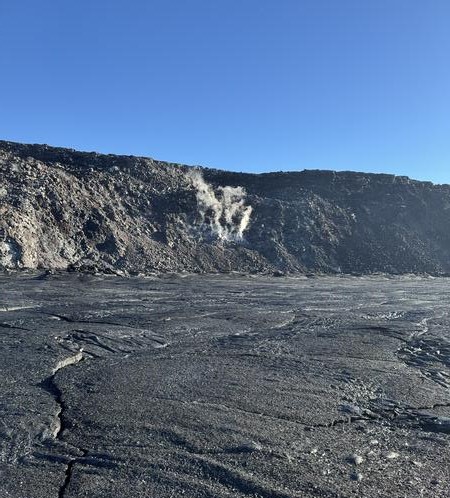
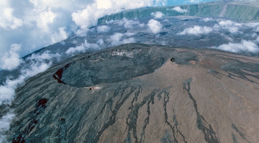
The USGS Hawaiian Volcano Observatory often gets asked how long it will take the lava flows to fill in Halemaʻumaʻu crater and spill onto the upper caldera floor of Kīlauea. This photo, taken from the floor of the crater, shows the lava flows from episode 37 (November 25) where they contact the north wall of the crater, which rises several hundred feet above. On average, lava flows at the base of Halemaʻumaʻu have an elevation of 3219 feet (981 meters) above sea level (as of November 25, after episode 37), while the northeastern part of Kaluapele (Kīlauea summit caldera) above it is at an elevation of about 3500 feet (1067 meters) above sea level. This means that an addition 300 feet (91 meters) of lava will need to fill the crater before lava flows spill onto the upper caldera floor.
Since the end of episode 38, Kilauea has inflated 6.5 microradians as recorded on the UWD tiltmeter with 3.5 microradians of that gained in the past 24 hours. The UWD tiltmeter also recorded the teleseism from the Magnitude 7.6 earthquake in Japan at about 4:30 a.m. HST.
Volcanic gas emissions have greatly decreased with the end of the eruption and are back in the normal range of 1200 to 1500 tonnes per day of SO2.
Rift Zone Observations:
Rates of seismicity and ground deformation remain very low in the East Rift Zone and Southwest Rift Zone. SO2 emissions from the East Rift Zone remain below the detection limit.
Source : HVP
Photo : USGS / K. Mulliken.
La Réunion Island , Piton de la Fournaise :
Press release from the Paris Institute of Earth Physics / Piton de la Fournaise Volcanological Observatory, December 8, 2025 – 7:20 PM local time – 3:20 PM UTC
Seismic activity has returned over the past 24 hours to a level comparable to that observed before the eruption of December 5, 2025, namely 1 to 3 earthquakes per hour.
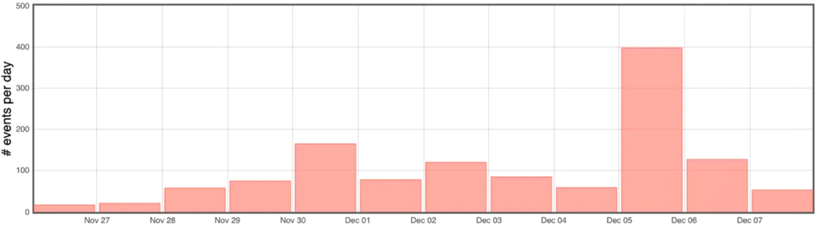
Histogram showing the number of shallow volcano-tectonic earthquakes per day recorded since November 26, 2025 (© OVPF-IPGP).
At this stage, further intrusion can now be ruled out, and the intrusion can be considered definitively halted. Any further magma injection from the reservoir will be accompanied by a seismic crisis.
Nevertheless, the continued seismicity and slow inflation of the summit area indicate that the pressurization of the shallow magma reservoir is ongoing.
This pressurization process of the shallow reservoir can last from several days to several weeks before the reservoir roof ruptures, resulting in magma injection towards the surface and potentially an eruption, but it can also cease without leading to an eruption in the short term.
Source : direction de l’OVPF-IPGP.
Photos : OVPF-IPGP , Clicanoo.
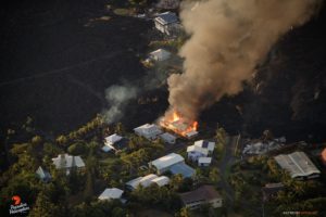
Colombia , Puracé – Los Coconucos volcanic chain :
Popayán, December 8, 2025, 8:50 a.m.
Regarding the monitoring of activity in the Los Coconucos volcanic chain, the Colombian Geological Survey (SGC), an agency under the Ministry of Mines and Energy, reports the following:
Since the publication of yesterday’s extraordinary bulletin and up to the date of this announcement, earthquakes related to fluid movements within the volcanic edifice have continued to be recorded. These include long-period (LP) earthquakes, tremor pulses (TR), and continuous tremor. This seismicity has been located primarily beneath the Puracé volcano crater and is linked to the internal dynamics of gases and their emission into the atmosphere. In addition, low-magnitude seismic signals, associated with rock fracturing, were recorded under the eastern flank of the volcano, less than one kilometer from the crater and at depths between one and three kilometers.
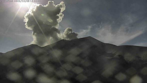
Recording from the Mina camera, located 2.2 km north of the Puracé volcano. Gas and ash column recorded at 8:00 a.m. on December 8, 2025, reaching a height of 700 meters above the summit of the Puracé volcano.
Some of these seismic signals were accompanied by ash emissions that dispersed mainly eastward, following the wind direction. The eruption that occurred this morning at 8:00 a.m. is noteworthy, reaching a height of 700 meters above the summit of the volcano. In total, four (4) ash emissions were recorded at the Puracé volcano crater, triggering alerts from the Civil Aviation Authority. Significant sulfur dioxide (SO₂) emissions continue to be detected by satellite, dispersing mainly to the northeast within a 150 km radius of the volcano. Similarly, a temperature increase is still being observed in the crater area, possibly linked to the emission of hot gases from inside the volcano. As long as the orange alert remains in effect, temporary fluctuations in volcanic activity are possible.
The volcanic activity alert level remains at ORANGE: volcano showing significant changes in monitored parameters.
Source et photo : SGC.
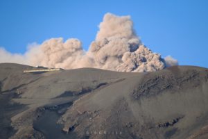
Indonesia , Lewotobi Laki-Laki :
SPECIAL REPORT ON THE CHANGE IN ACTIVITY LEVEL OF MOUNT LEWOTOBI LAKI-LAKI, FROM LEVEL IV (AWAS) TO LEVEL III (SIAGA), December 8, 2025, 3:00 PM WITA.
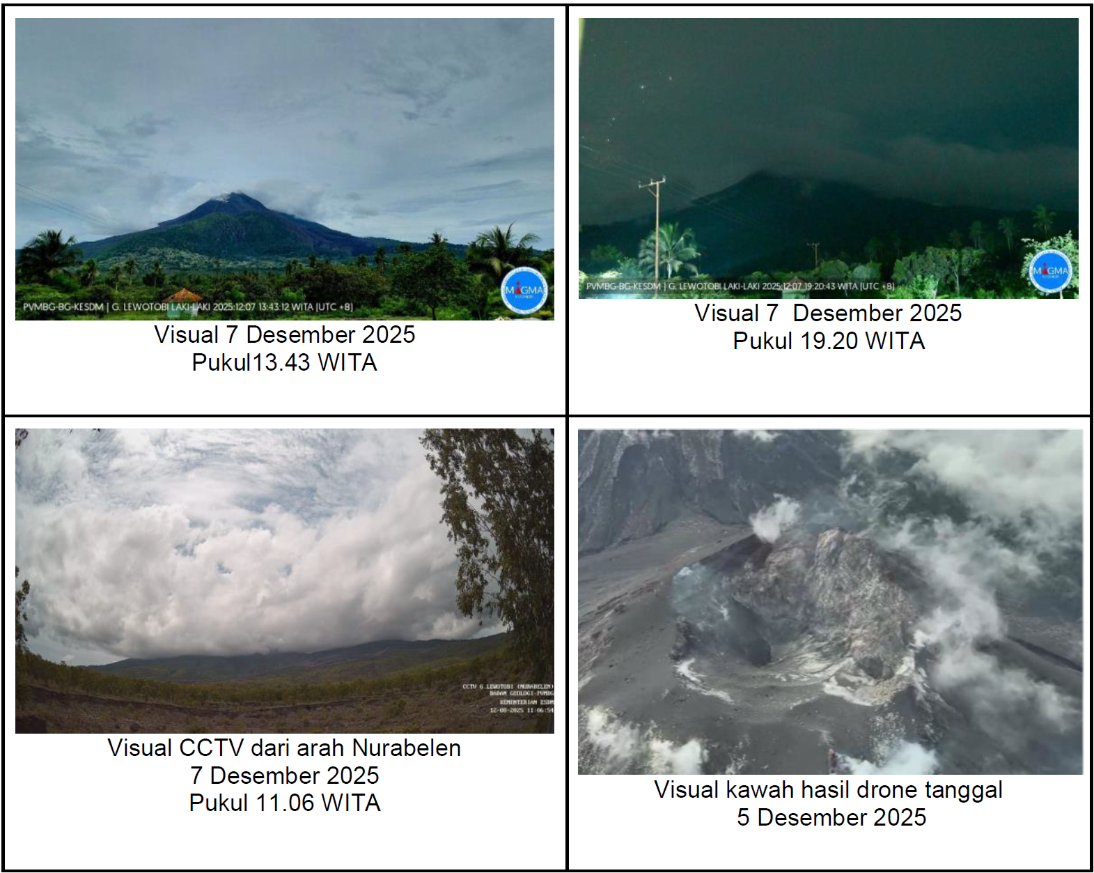
Visual monitoring shows that the volcano is clearly visible until it becomes shrouded in fog. White smoke of low to moderate intensity is emanating from the main crater and rising approximately 50 to 108 meters above the summit.
Seismic data collected on December 7 and 8, 2025, up to 12:00 WITA, reported one emission earthquake, 27 non-harmonic tremors, 7 low-frequency earthquakes, one deep volcanic earthquake, 2 local tectonic earthquakes, 12 distant tectonic earthquakes, and 4 flood/lahar tremors.
From December 1 to 7, 2025, volcanic activity at Mount Lewotobi showed a marked decrease. Visual data recorded a decline in the intensity of surface activity, while the continued fluctuations in avalanche earthquakes more likely reflect the process of adjusting materials on the slope toward stabilization. A slight increase in emission earthquakes was observed, but this indicates the release of gas pressure from the surface layers, rather than an escalation toward an eruption.
Seismic data confirm this decrease in activity. Non-harmonic tremors decreased significantly, indicating that the previously substantial magma supply is now filling shallow fractures at a slower rate. While harmonic tremors and low-frequency earthquakes did increase, this activity reflects deep fluid movement, not a strong migration of magma toward the surface. The absence of recorded shallow volcanic earthquakes also confirms the absence of significant pressure in the surface zone, pressure which usually triggers eruptions.

Deep volcanic seismic activity has decreased considerably over the past two weeks, although no energy release has occurred over the past three weeks. This contrasts with previous trends, which typically follow a sudden surge in magma that triggers an eruption. This indicates both a blockage of the conduit and a decrease in magma supply. Tectonic activity, both local and distant, remains fluctuating but does not appear to have significantly influenced the increase in volcanic activity. Deformation data from tiltmeters and GNSS show a downward trend from October to early December 2025, suggesting the absence of new magma pressure within the volcano.
Overall, the parameters—visual, seismic, and deformation—indicate that Mount Lewotobi is currently experiencing a period of subsidence. No tangible signs of a new magma input likely to trigger a major eruption in the near future have been observed. Nevertheless, increased vigilance and close monitoring of potential lava flows during the rainy season remain essential.
Based on these visual and instrumental analyses, the activity level of Mount Lewotobi Laki-laki has been downgraded from AWAS (Level IV) to SIAGA (Level III).
Source et photos : PVMBG.
Chile , Puyehue / Cordon Caulle :
Seismology
The seismic activity of the period was characterized by the recording of:
472 VT-type seismic events, associated with rock fracturing (volcano-tectonics). The most powerful earthquake, with a local magnitude (ML) of 2.4, was located 2.1 km north-northeast and at a depth of 2.6 km relative to the 2011 eruptive center.
5 LP-type seismic events, associated with fluid dynamics within the volcanic system (long period). The amplitude of the largest earthquake, measured by the reduced displacement parameter (DR), was 4 cm².
Fluid Geochemistry
No anomalies were observed in sulfur dioxide (SO₂) emissions into the atmosphere near the volcanic complex, according to data published by the Tropospheric Monitoring Instrument (TROPOMI) and the Sulfur Dioxide Group of the Ozone Monitoring Instrument (OMI).
Geodesy
Geodetic activity during the period was characterized by:
– Variations in the length of the line (distance between GNSS stations) indicate stability of the monitoring line, with the elongation rate decreasing from approximately 1.5 cm/year to 0.3 cm/month.
– High amplitude rates in the vertical components of the GNSS stations, although lower than those of the previous period, were still observed in the graben area (northwest of the 2011 eruptive center), reaching 0.95 cm/month.
– Interferometric analysis of Sentinel-1A images, taken between February 9, 2024 and November 24, 2025, shows constant swelling in the graben sector, indicating an uplift of approximately 16 cm over the past 21 months.
Therefore, we can conclude that deformation (swelling) in the graben area is continuing, albeit at a slower rate than in previous periods.
Satellite Thermal Anomalies
During the study period, low-power thermal anomalies were recorded at the laccolith, northeast of the 2011 eruption epicenter. These anomalies reached a maximum Volcanic Radiation Power (VRP) of 2 MW on November 5 and 25, according to data processed by the VIIRS750 and VIIRS375 sensors of the MIROVA platform (Mid-Infrared Volcanic Activity Observation).
Sentinel-2-L2A and Landsat 8-9 satellite images did not detect any significant radiance anomalies within the volcanic complex.
Surveillance Cameras
Images from fixed cameras installed near the volcanic complex have not recorded any degassing feathers or variations related to surface activity.
Satellite Geomorphological Analysis
Analysis of PlanetScope Scene and Sentinel-2-L2A satellite images has not revealed any morphological changes related to volcanic activity.
Activity has remained low, suggesting stability of the volcanic complex. The volcanic technical alert level remains at the following:
GREEN TECHNICAL ALERT: Active volcano with stable behavior – No immediate risk
Source : Sernageomin
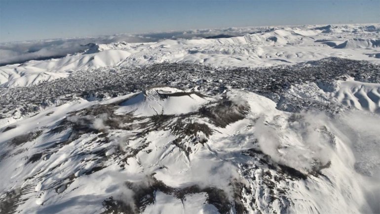
Photo : lmneuquen.