December 2 , 2025.
Hawaii , Kilauea :
HAWAIIAN VOLCANO OBSERVATORY DAILY UPDATE , U.S. Geological Survey
Monday, December 1, 2025, 9:48 AM HST (Monday, December 1, 2025, 19:48 UTC)
19°25’16 » N 155°17’13 » W,
Summit Elevation 4091 ft (1247 m)
Current Volcano Alert Level: WATCH
Current Aviation Color Code: ORANGE
Activity Summary:
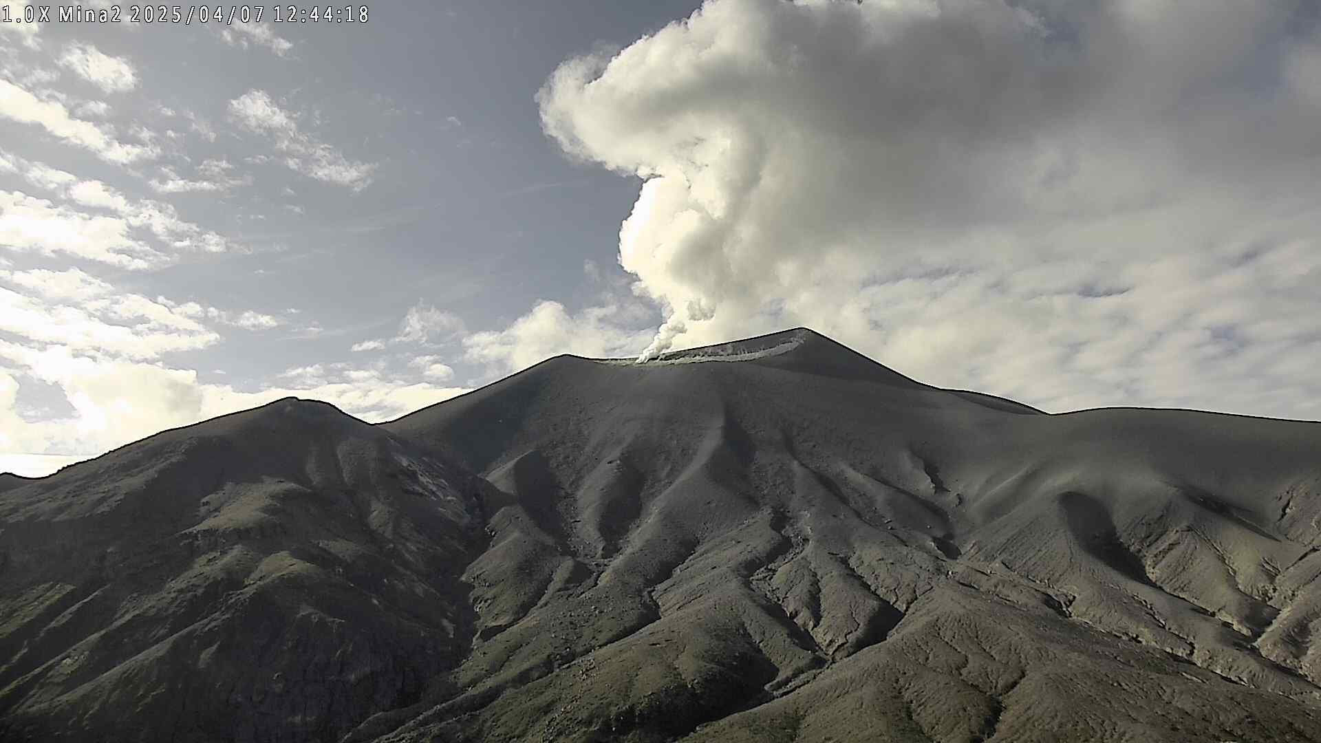
Eruptive activity is paused. Summit inflation has stalled over the past day. However, the recent inflation of the summit and glow from the vents indicate that another fountaining episode is likely between December 5 and 10, based on ground deformation models. These dates may be updated if summit inflation remains stalled.

Summit Observations:
Eruptive activity is paused following the end of episode 37 lava fountaining on Tuesday, November 25. Overnight moderate glow was observed from the south vent, and minor glow from the north vent, along with occasional tremor spikes suggestive of gas pistoning at depth within the vents.
As of this morning, about 9.5 microradians of inflationary tilt have been recorded by UWD since the end of episode 37, however, the tiltmeter has been flat since yesterday morning, indicating that summit inflation has stalled. Seismic tremor is low.
Gas emissions continue from the vent area, with a white outgassing plume rising above the crater this morning. Sulfur dioxide (SO2) gas emissions are typically between 1,200 and 1,500 tonnes per day during eruptive pauses between lava fountaining.
Rift Zone Observations:
Rates of seismicity and ground deformation remain very low in the East Rift Zone and Southwest Rift Zone. SO2 emissions from the East Rift Zone remain below the detection limit.
Source et photo : USGS.
United – States , Yellowstone :
YELLOWSTONE VOLCANO OBSERVATORY MONTHLY UPDATE , U.S. Geological Survey
Monday, December 1, 2025, 1:30 PM MST (Monday, December 1, 2025, 20:30 UTC)
44°25’48 » N 110°40’12 » W,
Summit Elevation 9203 ft (2805 m)
Current Volcano Alert Level: NORMAL
Current Aviation Color Code: GREEN
Summary
Yellowstone Caldera activity remains at background levels, with 251 located earthquakes in November (largest = M3.2). Deformation measurements indicate no significant changes in surface displacement patterns since the summer.
Recent Work and News
At least two small eruptions occurred at Black Diamond Pool in Biscuit Basin, site of a hydrothermal explosion in 2024. The eruptions were captured by camera views and infrasound (acoustic) monitoring on November 22 and 29. Minor eruptions of Steamboat Geyser in Norris Geyser Basin remain sporadic, indicating that a major eruption is unlikely anytime soon. There have only been 2 major eruptions of the during 2025, and the period of frequent activity that started in 2018 has probably ended.
Seismicity
During November 2025, the University of Utah Seismograph Stations, responsible for the operation and analysis of the Yellowstone Seismic Network, located 251 earthquakes in the Yellowstone National Park region. The largest event of the month was a minor earthquake of magnitude 3.2 located about 14 miles south-southwest of Mammoth Hot Springs in Yellowstone National Park on November 9 at 5:00 p.m. MST.
November seismicity in Yellowstone was marked by three swarms:
1. An area of ongoing seismicity that began in late September continued through November, adding 70 earthquakes to the sequence approximately 14 miles south-southwest of Mammoth Hot Springs in Yellowstone National Park. The largest November earthquake (described above) is in this sequence.
2. A swarm of 105 earthquakes occurred approximately 16 miles west-northwest of Lake in Yellowstone National Park during November 2–30. The largest earthquake in the sequence was a magnitude 2.5 on November 5 at 7:25 p.m. MST.
3. A swarm of 11 earthquakes took place approximately 13 miles northeast of West Yellowstone, Montana, during November 26–27. The largest earthquake in the sequence was a magnitude 2.0 on November 27 at 2:45 a.m. MST.
Earthquake activity in Yellowstone is slightly above background levels.
Ground Deformation
Continuous GPS stations in Yellowstone Caldera recorded little net deformation over the past month, suggesting that the seasonal summertime pause in subsidence or transition to slight uplift may not be over just yet. There has also been no net deformation in the area of Norris Geyser Basin since mid September. Many GPS stations in the region showed spurious signals at the end of November due to winter weather conditions.
Source et photo : YVO
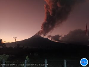
Indonesia , Semeru :
Mount Semeru erupted on Monday, December 1, 2025, at 7:44 AM Western Indonesian Time. An ash column was observed approximately 600 meters above the summit (at an altitude of about 4,276 meters). This column, white to gray in color and of moderate intensity, was drifting southward. At the time of writing, the eruption was still ongoing.

VOLCANO OBSERVATORY NOTICE FOR AVIATION – VONA
Issued : 20251201/0044Z
Volcano : Semeru (263300)
Current Aviation Colour Code : ORANGE
Previous Aviation Colour Code : orange
Source : Semeru Volcano Observatory
Notice Number : 2025SMR3393
Volcano Location : S 08 deg 06 min 29 sec E 112 deg 55 min 12 sec
Area : East java, Indonesia
Summit Elevation : 11763 FT (3676 M)
Volcanic Activity Summary :
Eruption with volcanic ash cloud at 00h44 UTC (07h44 local).
Volcanic Cloud Height :
Best estimate of ash-cloud top is around 13683 FT (4276 M) above sea level or 1920 FT (600 M) above summit. May be higher than what can be observed clearly. Source of height data: ground observer.
Other Volcanic Cloud Information :
Ash cloud moving to south. Volcanic ash is observed to be white to gray. The intensity of volcanic ash is observed to be medium.
Remarks :
Eruption recorded on seismogram with maximum amplitude 22 mm and maximum duration 115 second.
Source et photo : PVMBG.
Colombia , Puracé – Chaîne volcanique Los Coconucos :
Popayán, December 1, 2025, 9:00 AM
Regarding the monitoring of activity in the Los Coconucos volcanic chain, the Colombian Geological Survey (SGC), an agency under the Ministry of Mines and Energy, reports the following:
Since the publication of yesterday’s extraordinary bulletin and up to the date of this announcement, seismic signals related to fluid movements, including tremors (TR) and long-period (LP) earthquakes, have been recorded beneath the Puracé volcano crater and are associated with the continuous emission of volcanic gases into the atmosphere. Some of these signals were accompanied by small ash emissions, the dispersal of which was primarily influenced by variations in wind patterns.
The observed gas and ash plumes reached heights exceeding 700 m, but it is impossible to calculate their total height using the camera network installed in the volcano’s area of influence due to adverse weather conditions. During the period covered by this bulletin, four alerts were issued to civil aviation authorities, including yesterday’s alert at 9:23 p.m., corresponding to a volcanic tremor signal with a plume exceeding 700 m above the summit of Mount Puracé and dispersing eastward. To date, no reports of ashfall have been received from communities located near the volcano.
While the orange alert remains in effect, temporary fluctuations in volcanic activity are possible; in other words, activity may decrease at times compared to previous days or weeks, without necessarily indicating that the volcano has returned to a stable level of activity. For a return to more stable activity (yellow alert), a reasonable time is needed to assess all monitored parameters and determine trends that may indicate reliable stability.
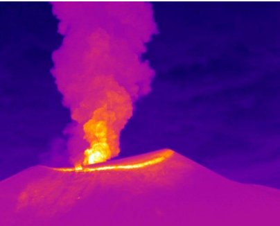
Recording from the Mina infrared camera, located 2.2 km north of the Puracé volcano. Gas and ash column recorded at 9:26 PM on November 30, 2025, with a minimum height estimated at 700 m above the summit of the Puracé volcano.
Given this information, the Colombian Geological Survey (SGC) recommends staying away from the crater and surrounding areas, closely monitoring the situation through special bulletins and other information published on its official channels, and following the instructions of local and departmental authorities and the National Unit for Disaster Risk Management (UNGRD).
The volcanic alert level remains at orange: volcano exhibiting significant variations in monitored parameters.
Source et photo : SGC
Costa Rica , Rincon de la Vieja :
Latitude: 10.83°N
Longitude: 85.34°W
Altitude: 1916 m
Current Activity Level: Alert
One small eruption and two exhalations were recorded this week. The largest occurred on November 25 at 1:10 a.m. Neither generated lahars. Sporadic pulses of short tremors are observed, with variations in amplitude, frequency, and duration. These short tremors are generally associated with eruptions. An increase in volcano-tectonic earthquakes is observed both near and far from the crater, with distal earthquakes being predominant. The occurrence of long-period and helical earthquakes continues. The number of long-period earthquakes is stable and shows a downward trend. A slight decrease in the frequency of long-period helical signals was observed this week.
Geodetic observations show subsidence of the volcanic massif, more pronounced at the summit. This week, DOAS stations recorded an increase in SO2 flux (506 ± 319 t/d) compared to the previous week (224 ± 137 t/d). The last detection of SO₂ in the atmosphere by satellite measurement, linked to the activity of Rincón de la Vieja, dates back to September 7.
The Santuarium hot spring, located 4 km north of the active Rincón crater, recently recorded a temperature of 33.3 °C, a pH of 3.80, and an SO₄²⁻/F⁻ ratio of 46 on October 29, 2025. It is important to note, regarding the geochemistry of Santuarium, that the average values of these parameters, measured by OVSICORI-UNA between August 1989 and October 2025 (32.5 °C, pH = 3.96, and SO₄²⁻/F⁻ ratio = 38.5), are close to the specific values measured in October 2025. Therefore, the geochemistry of the Santuarium hot spring has remained stable over the long term, with fluctuations primarily linked to exogenous factors (precipitation patterns).
Source : Ovsicori
Photo : Raul Mora / RSN / UCR